
Freudenstadt
| coat of arms | Germany map | |
|---|---|---|

|
Coordinates: 48 ° 28 ' N , 8 ° 25' E |
|
| Basic data | ||
| State : | Baden-Wuerttemberg | |
| Administrative region : | Karlsruhe | |
| County : | Freudenstadt | |
| Height : | 732 m above sea level NHN | |
| Area : | 87.58 km 2 | |
| Residents: | 23,635 (Dec. 31, 2019) | |
| Population density : | 270 inhabitants per km 2 | |
| Postal code : | 72250 | |
| Primaries : | 07441, 07442, 07443 | |
| License plate : | FDS, HCH , HOR, WOL | |
| Community key : | 08 2 37 028 | |
City administration address : |
Marktplatz 1 72250 Freudenstadt |
|
| Website : | ||
| Lord Mayor : | Julian Osswald ( CDU ) | |
| Location of the city of Freudenstadt in the Freudenstadt district | ||
  |
||


Freudenstadt is a large district town with 23,635 inhabitants (December 31, 2019) in the administrative district of Karlsruhe in Baden-Württemberg and the seat of the district of Freudenstadt . Freudenstadt is a recognized climatic and Kneipp health resort as well as a traditionally popular vacation spot. For the surrounding communities it forms a middle center in the area of the regional center Pforzheim . There is an agreed administrative community with the municipalities of Bad Rippoldsau-Schapbach and Seewald .
The city was founded in 1599 by Duke Friedrich I of Württemberg . The city fire of 1632, the large population losses in the Thirty Years' War and the extensive destruction of the inner city in the Second World War caused sharp cuts in urban development .
geography


location
Freudenstadt is located in the north-eastern Black Forest . It is located 66 kilometers (as the crow flies) southwest of Stuttgart and 61 kilometers south of Karlsruhe on a high plateau on the eastern edge of the Northern Black Forest at an altitude of 591 to 968 meters in the Northern Black Forest region . The high plateau lies on the edge of a gently sloping incline to the east. This is the catchment area of the Glatt , which then flows into the Neckar . Immediately to the west of the city center, the terrain drops steeply to the deeply cut valley of the Forbach , which flows to the Murg . The Kinzig rises six kilometers to the south, in the climatic health resort Loßburg , and flows into the Rhine at Kehl. The largely forest-covered western urban area rises to the top of the pass at Kniebis and from there to a height of 968 meters at the Alexanderschanze . The river Wolf rises south of the Kniebis district .
Neighboring communities
The following cities and municipalities border the city of Freudenstadt in a clockwise direction , starting in the north: Baiersbronn , Seewald , Grömbach , Pfalzgrafenweiler , Dornstetten , Glatten , Loßburg and Bad Rippoldsau-Schapbach (all districts of Freudenstadt ).
geology
The city is located in an overburden of Trias , which is located on an older basic mountain base. The predominant red sandstone deposits were disturbed in the course of the Tertiary by the Freudenstädter Graben , a twelve kilometer long and seven kilometer wide ditch with faults of up to 140 meters jump height. As in the neighboring Gäu to the east, the bottom of the trench consists of shell limestone. Especially at the edges of the ditch, for example in the Christophstal not far from today's city center, hydrothermal solutions have formed quartz - barite - passages .
A first, albeit weak, reference to historical mining in the Freudenstädter Revier is contained in a document from 1267. Further references from the Middle Ages are missing. The main phase of mining was in the period 16-18. Century. As is the rule in the Württemberg Black Forest, this also encountered great economic difficulties and was often interrupted. Above all, silver, copper and iron ores were mined. The limonite , which occurs in abundance near the surface, was mined for iron extraction and arsenic-rich pale ore was mined for silver and later also copper . The pale ores of the districts in the overburden have an increased bismuth content . The dismantling led to the first settlement of the Christophstal around 30 years before Freudenstadt was founded.
In 2008, the State Office for Geology, Raw Materials and Mining identified a “considerable” barite potential when drilling compared to other German dike areas . A trial dismantling is currently taking place at the Dorothea investigation tunnel near the valley road in Forbachtal.
City structure
The urban area of Freudenstadt is divided into the core town of Freudenstadt with Christophstal and Zwieselberg (together 16,159 inhabitants) and the districts of Dietersweiler and Lauterbad (2256 inhabitants), Grüntal and Frutenhof (1027 inhabitants), Igelsberg (254 inhabitants), Kniebis (947 inhabitants), Musbach (761 inhabitants) and Wittlensweiler (2186 inhabitants). The districts, in turn, are subdivided into villages, hamlets, farms and houses.
The districts are officially named in the form of “Freudenstadt, district ...” With the exception of Kniebis, the districts are formerly independent communities. In Freudenstadt, the false choice of suburbs has been introduced, that is, the urban area is divided into six residential districts in accordance with the Baden-Württemberg municipal code . The core city and the Igelsberg district are combined into one residential district, the remaining residential districts are identical to the districts. In the districts there are localities within the meaning of the Baden-Württemberg municipal code with their own local council and a local mayor as its chairman. There are administrative offices of the mayor's office in the localities .
Outbound , now-defunct villages and castles are the castle Hofstätten and the settlement castle hill in the Black Forest in the district Dietersweiler, Schöllkopf , one in the Thirty Years' War burnt down homestead, the settlements and isolated farms Wolf House in the district of Springvale, Slunwag in the district Igelsberg and Gallus hut and Hilpert Höfle in the Musbach district.
Spatial planning
Freudenstadt is a middle center within the Northern Black Forest region , in which Pforzheim is designated as a regional center . The towns and communities of Alpirsbach , Bad Rippoldsau-Schapbach , Baiersbronn , Dornstetten , Glatten , Grömbach , Loßburg , Pfalzgrafenweiler , Schopfloch , Seewald , Waldachtal and Wörnersberg belong to the middle center Freudenstadt .
climate
Already at the beginning of the 20th century there were regular measurements of the amount of rain, the duration of sunshine and other climatic values. In 1925 an advertisement said: "The largest average number of annual sunny days in Germany is in the city of Freudenstadt in Württemberg with 64.2 days (determination by the Prussian Meteorological Institute)".
The annual average temperature between 1990 and 2007 was 7.9 ° C. The highest average maximum temperature was found in August at 21.2 ° C, the lowest average minimum temperature in January at −2.2 ° C. Similarly, the highest and lowest daily average temperatures are distributed. The annual amount of precipitation measured between 1961 and 1990 is above average for Germany at 1,681.4 millimeters due to the city's location on the edge of the mountains. Quite constant values were recorded over the year, with the maximum of 189.9 millimeters being recorded in December. A similar picture emerges for the rainy days with a fairly homogeneous distribution of 15.2 days in June and July and 19.7 days in December. In the year there were an average of 205.6 rainy days. With the average daily hours of sunshine between 1990 and 2007, Freudenstadt achieved a high value of 4.6, which is probably due to the fact that it was largely free of fog. Most hours of sunshine were recorded in June (7.1 hours), the lowest in December with 1.8 hours. Weather data for Freudenstadt is collected from the control room of the German Weather Service on the elevated Kienberg . The company Meteomedia maintains weather stations on the market square and in Freudenstadt-Langenwald.
|
Monthly average temperatures and precipitation for Freudenstadt (Kienberg, 797 m above sea level)
Source:
|
|||||||||||||||||||||||||||||||||||||||||||||||||||||||||||||||||||||||||||||||||||||||||||||||||||||||||||||||||||||||||||||||||||||||||||||||||||||||||||||||||||||||||||||||||||||||||||||||||||||||||||||||||||||||||||||||||||||||||||||||||||||||||||||||
history
Later districts and mining in St. Christophstal


Today's Grüntal-Frutenhof district was first mentioned in a document in 1100 as Grindelen . The Frutenhof homestead, on the other hand, was only mentioned in writing in 1470. In 1583 Grüntal got its own parish. The existence of Igelsberg is secured as Illigsberg around the year 1230, when the Count Palatine Rudolf von Tübingen became a fief of the diocese of Strasbourg . Since 1381 Igelsberg belonged to the Benedictines - Klosterreichenbach and only came in 1595 to Württemberg.
In today's Kniebis there was a chapel of a Herrenalber monk around 1250 , which was converted into a Franciscan monastery in 1278 , which came to Württemberg in 1320. In order to protect himself against possible attacks by the Habsburg bishop of Strasbourg, Count Eberhard , who defected from the Habsburgs under Frederick the Fair to become Emperor Ludwig the Bavarian, built entrenchments on the Kniebis. The Musbach district, namely the present-day Untermusbach, found its way into documents as Muosbach in 1274 and was part of Württemberg from the start. Today's Untermusbach came to the Reichenbach Monastery from the Count Palatine of Tübingen in 1291. It was not until 1595 that it became part of Württemberg. Dietersweiler was first mentioned in 1347 as Dietrichsweiler . Together with the Wittlensweiler district, which already existed as Witelineswilare at the beginning of the 12th century , it was sold by the Lords of Lichtenfels to the Lords of Neuneck . Wittlensweiler went to Württemberg in 1473, Dietersweiler followed in 1511.
From 1520 to 1534, under Austrian rule, ore was mined near the former Schöllkopf homestead. In 1544 the monastery on the Kniebis was dissolved. Many small mines were built, the tunnels of which led horizontally into the mountain, including the "St. Christoph Erbstollen" named after Duke Christoph or his patron saint around 1560, whose name also refers to the valley section and the settlement that arose shortly afterwards. passed over. The steep slopes of the Christophstal favored the construction of tunnels, vertical shafts remained significantly behind in number and importance. But pits were not only dug in the Christophstal. The Charlottengrube was built near Lauterbad, the Georgsstollen and the “Schweitzer Treu” mine were built on the Kienberg. Mining was also carried out in the later districts: In Wittlensweiler, a mine was operated in Pfarrgasse between 1812 and 1824 ("Friedrich- und Wilhelmina-Fundgrub in Kirchgaß"), which mined heavy spar and brown iron.
The miners were given special privileges as early as 1536. In 1598, 87 tons of ore were mined, each ton containing up to 1,800 grams of silver and 140 kilograms of copper. The silver melt was heated with charcoal from the forests in the area. In 1603, 94 kilograms of silver were extracted. This is how the so-called Christophstaler emerged . Later mining focused on copper and iron.
On January 23, 1572, Duke Ludwig ordered the construction of a steel works. His successor Friedrich I ensured the establishment of further processing companies in view of the extensive self-sufficiency of raw materials in the duchy. In 1595, master builder Heinrich Schickhardt planned an iron forge, which would later become the upper large hammer. 1606–1610 a brass factory with kilns and forge was added. In 1616 the upper wire line was set up, in 1621 the lower one. A copper hammer, a pan hammer, and another large hammer, the later Wilhelm hammer, were created. A second smelter was set up between the copper hammer and the (lower) pan hammer. There was also a bell foundry in a place unknown today. Between 1622 and 1628 a mint was operated in the Christophstal , in which coins from the Kipper and Wipper times and later regular coins were minted.
urban planning
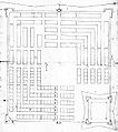
.jpg)
As a representative of early absolutism, Duke Friedrich I pursued an active power and economic policy. The promotion of mining in Christophstal and the settlement of Protestant religious refugees were supposed to secure the income of the sovereign in the mercantilist sense. The existing state fortresses were expanded. On the western flank, near the strategically important Kniebis Pass, a new fortified residence with Freudenstadt was supposed to secure further planned territorial acquisitions in the west as a bridge to the possessions on the west bank of the Rhine. In 1595 the Duke bought Besigheim and Mundelsheim of Baden. In the same year he enforced his claims against Reichenbach by force. His further aim was to acquire the diocese of Strasbourg . In 1604 he obtained the Oberkirch pledge from this diocese for at least thirty years . Friedrich commissioned his master builder Heinrich Schickhardt around 1598 to investigate the area around today's Freudenstadt. Looking back, Schickhardt reports in 1632 in the summary of his life's work ("inventory"):
" Since it was still a forest, I had my first eyesight, had the soil explored quite deeply in many underside places, but found few guots, which because of my underthonigkhait I thought it was not necessary to build a statute there [...] "
Nevertheless, the duke insisted on building the city. Schickhardt's square floor plan for Freudenstadt probably goes back to drawings by Albrecht Dürer in his fortress theory . Schickhardt designed Freudenstadt at the behest of Friedrich I on the drawing board . First, he presented the duke with what is known as the building block plan, in which several houses are laid out in rows or in rectangles, some with an inner courtyard. The massive fortress with the castle was planned in this first plan in a corner of the complex, the market square in the center of the city was planned to be relatively small. Schickhardt's second draft is a further development of the building block plan. There are already clear beginnings of the rows of houses that were realized later. The castle in the then usual construction was again embedded in the fortress walls in a corner of the complex. In fact, Freudenstadt was then built according to the three-line plan , with the castle and fortress now planned in the center of the city being built later. This decision allowed the city to expand flexibly until a constant number of inhabitants was reached. In the three-line plan, the castle was planned to be centered on the market square and rotated 45 ° to the geometric city. The planned massive construction of the fortress was withdrawn and looks more like a city wall, which suggests that the duke was no longer interested in the military function of his city at this point. Nevertheless, a plan by Schickhardt is known which expanded the three-line plan to include a mighty fortress. However, it is not known whether this was more a "gimmick" or real planning. The center is surrounded on the plan by three rows of houses that are reminiscent of a mill board . Even the names of the first residents, mainly craftsmen, who wanted to benefit from the construction of the new city, are registered. These comments are likely to come from Elias Gunzenhäuser, the local site manager.

First draft ("building block plan")
Second draft (building block plan with clear elements of the line plans)

Third, final draft ("three-line plan")

Draft for a three-line plan expanded to include a fortress

"Gable house" in the typical half-timbered style with "arcades"

Arrangement of the "gabled houses" on the market square

Draft for the expansion of the city in 1604 ("five-line plan")

Sketch of the planned fortification around 1612


City foundation
March 22, 1599, when the first houses and streets of Schickhardt were marked out in the presence of the Duke, is considered to be the founding date of the city. The houses on the market square had roof gables facing the square and were therefore called "gabled houses". They were typical half-timbered houses . A frame made of beams set up by the carpenter was filled with masonry and lightly plastered, while the beams, some of which remained visible, were painted dark. Today there are no more houses like this in the city center. In Dornstetten , which is not far away , this type of construction is still visible in the historic town center.
On May 1, 1601, the foundation stone was laid for the town church, which was probably designed by Elias Gunzenhäuser and was built on the market square as an angular church . From 1602 the department store was built in the north-west corner - also by Gunzenhäuser - and the town hall in the north-east corner in the 1660s, both also as angular buildings. On May 6, 1601, the "City above Christophstal" was first mentioned in a document as "Freudenstadt". How this name came about is not clear. Then on November 3rd, a tender was issued that specifically addressed those willing to settle, who were promised a building site, wood and fields. In this way, mainly Protestant religious refugees from the Austrian crown lands of Styria , Carinthia and Carniola , who were affected by the Habsburg Counter-Reformation , were directed to the young city. Since many refugees from Carniola only spoke Slovene , a Slovene pastor soon also preached. In 1603 the young city received a coat of arms and the first mayor , two years later its district . For this purpose, parts of the Dornstetter Waldgedings and the neighboring municipality of Baiersbronn were separated. Freudenstadt became the seat of a small office .
Since the population developed well, Duke Friedrich I ordered the expansion of the city complex. Schickhardt then created the five-line plan . Two additional rows of houses, together with the three existing approximately 2,500 residents, should provide living space. In 1608 Duke Friedrich I of Württemberg died. Since the previous parcels of the now four- row town were not yet fully developed at this point in time, the citizens asked his son and successor, Johann Friedrich von Württemberg , to give up at least the extension of a fifth row of houses; the request was granted. After Duke Friedrich's death, the plans for the palace in "Friedrichs Stadt" were no longer taken into account. The free area in the center thus remained a huge square, which is now considered the 'largest built-up marketplace ' in Germany (see below: City relationship, including to Heide with the 'largest undeveloped marketplace' in Germany). In addition, the city had no city wall for a long time. There were always plans for this (for example Schickhardt's plan from 1612, see above); in some cases work was started, but it was not actually completed.
In 1619 the mayor of Freudenstadt asked Duke Johann Friedrich in vain for a city wall. The city was too poor to finance a fortification itself, so a wooden fence was built around the city in the following years. This fence is clearly recognizable on the Merian engraving from 1643. The first incorporation into the young city took place in 1616 with the hamlet of St. Christophstal.
Years of misery and revival

Only a few years after it was founded, when Freudenstadt is said to have had almost 3,000 inhabitants, the plague broke out in 1610/11; it is said to have carried away 800 people, and another 900 emigrated as a result. Animal diseases and poor harvests made the situation worse. In 1632 a fire broke out in the Zum Güldenen Barben inn on the lower market square, which quickly spread due to the arrangement of the half-timbered houses in rows of houses. Heinrich Schickhardt notes the extent of the damage:
“ On May 24th in the year 1632 an extremely low heat broke out in Fredenstatt, [3 people died and 144 houses burned down. The fire broke out in the inn at the Güldenen Barben, which was the first house ever in this city. A ruling has been made that to build the burned down houses, they need 8 scrapers of oak and fir timber: 18,577 logs, boards 44,125 and slats 44,350.] "
After the lost battle of Nördlingen in the Thirty Years' War , buildings were again set on fire by imperial - Habsburg troops and the few remaining inhabitants were almost completely murdered and looted. The population in those days is likely to have been in the lower double-digit range. The plague broke out again in 1635 and again destroyed almost all life. Freudenstadt remained largely deserted for years. Even in 1652, almost twenty years after the tragic events, only about 300 citizens are recorded.
Fortress
The course of the Thirty Years War prompted Duke Eberhard III. to revisit urban development and fortification plans. Eberhard III. was considered to be very fond of the Freudenstadt people, he helped the population in many ways. In order for the residents to stay in the city, they were promised six years tax exemption. New citizens did not have to pay taxes for twelve years. There were cheaper building sites, the timber was given away. For the first time after the long war, the offices were filled again. The Latin school, a corner building behind the town church, was also reopened. Life began to flourish again in Freudenstadt.
In 1667, Duke Eberhard III. Finally, according to the ideas of the engineer d'Avila, start building a huge fortress. Matthias Weiß (1636–1707) was in charge of construction, supported by Georg Ludwig Stäbenhaber, who later became known as a cartographer . It was built until 1674. The fortress now covered an area twice as large as the inhabited city. It consisted of eight bastions with curtains (connecting walls ) and four city gates. Due to the steep slope towards the Christophstal, the three western bastions were much smaller than the other five bastions.
City gates
The Royal Statistical-Topographical Bureau describes the four “massive, very solid, vault-like” city gates built in 1858 in more detail. The Stuttgart gate in the east was decorated with "cannon and mortar barrels carved out of stone" and bore the ducal inscription EHZW 1668 (for Eberhard Herzog zu Württemberg) as well as the Württemberg and Dettingen coats of arms. It also housed higher district court prisons. The Strasbourg Gate in the south was “less ornate” and received the same coat of arms and the inscription 1678. Above the archway there was a rented apartment and a prison for the Oberamt and the Oberamtsgericht. The Murgthal-Thor in the west comprised the apartment of the senior clerk and two prisons of the senior clerk Freudenstadt. The inscriptions read EHZW 1631 on the outside and FCHZW 1681 on the inside. This corresponds to the initials of Friedrich Carl , the guardian of Duke Eberhard Ludwig . The Hirschkopf-Thor in the north, inscribed with the year 1622, was the oldest city gate. There the apartment of the High Court Clerk and three prisons of the High Court were housed.
Fortress plan

Except for the citadel shown on the left on the Kienberg - it was not built - the plan corresponds to the state of the fortress when the construction work was completed in 1674.
Decay of the fortress
In 1674 - the fortress was not yet completely finished - Duke Eberhard III died. ; construction was stopped immediately. His successor, Duke Wilhelm Ludwig , had Lieutenant Colonel Andreas Kieser draw up an appraisal of the fortress. This report only contains arguments against the fortress; this made it easy for Duke Wilhelm Ludwig to end the unpopular, expensive project.
The population took advantage of the government's lack of interest in the fortress and bought building materials from the fortress walls for decades. The hewn stones were found in private buildings, ditches and walls became gardens and pastures for the small cattle. The city took this into account and leased individual parts of the fortress to the citizens. The agricultural use and later the overbuilding changed the appearance of the fortress.
In 1820 it was planned to convert the remains of the Freudenstadt Fortress into a federal fortress. The Federal Assembly then decided to build federal fortresses in Ulm and Rastatt . From 1870 the city gates were sold for demolition and the fortress was finally left to decay. In 1880 only the fortifications in the area of today's city station and east of it were well preserved.

Wall Church of Peace

Wall Church of Peace

Coat of arms of Duke Eberhard III. (left) and that of his second wife Maria Dorothea Sophia von Oettingen (right)

Pillar from the Loßburger Tor


Today there are only very few remains of the fortress, e.g. B .:
- Between Blaicherstrasse and Musbacher Strasse, behind the Friedenskirche, there is a short, fairly well-preserved part of the “eastern bulwark”, it is still around 5 m high today.
- In the vicinity of the city station, on the corner of Dammstrasse and Wallstrasse, the remains of a wall can still be seen.
- A coat of arms stone with a grimace is the only remnant of the earlier Loßburger Tor (demolished in 1865) is set into the wall of the Kurhaus. On the left it shows the coat of arms of Duke Eberhardt (Württemberg stag bars, diamonds from Teck, Reichssturmfahne and the barbs from Mömpelgard ), on the right the coat of arms of his wife, Maria Dorothea Sofie, née Countess von Öttingen .
- In the Stuttgarter Straße, at the entrance to the former tax office, there are 2 pillars with decorative stones and peepholes from the Loßburger Tor.
Fortification walls were built on the Kniebis from 1674 to 1675 for the imperial war against Louis XIV , the Sun King . Duke Karl Alexander had this expanded to Fort Alexander , now commonly known as Alexanderschanze . It was the scene of hostilities between Austrians and French during the coalition wars from 1799 to 1801 . The Kniebis monastery building also fell victim to a fire.
From the garrison town to the Oberamt and health resort
In 1721 the Gut Lauterbad, which was founded by Christoph Wilhelm Dietrich and named after it, was one of the first buildings in the Lauterbad hamlet, which is now part of the Dietersweiler district .
In 1737 Freudenstadt became the location of a small garrison. In 1759, the Freudenstadt office was elevated to a higher office . In 1784 mining was completely stopped with the closure of the Dorothea tunnel in the Christophstal. The Oberamt Freudenstadt was one of the smallest offices in Old Wuerttemberg . In 1807, one year after the founding of the Kingdom of Württemberg and the associated upheavals in the administrative structure , the Freudenstadt district increased significantly in size. In 1833 the urban area was enlarged by around 2,300 hectares of the former forest estate. In 1837 a “sick ward” opened with four beds. Freudenstadt was increasingly becoming a city of handicrafts, which was facilitated by the connection to the route network of the Württemberg railway with the Gäubahn in 1879. In 1864 the Freudenstadt city gates were torn down. In 1876, Hartranft, the then city school, announced the intention to make Freudenstadt a health resort with its pure air . The project succeeded, and towards the end of the 19th century a steadily growing health resort began. The most famous hotels of the time included the Hotel Rappen, the Hotel Waldlust owned by the Luz family of hoteliers and the Kurhaus Palmenwald owned by the Stuttgart entrepreneur Paul Lechler . In total there were around 20 hotels in the small town around 1930, five of which were of the highest category. Freudenstadt was known worldwide as a health resort and attracted guests such as the English King George V , the Swedish Queen, John D. Rockefeller , Mark Twain and the Sultan of Selangor .
The district hospital in Herrenfelderstrasse was opened in 1888 . Two city doctors and two deaconesses took up their duties. The city became a popular vacation spot for big city dwellers. In 1899, on the occasion of the 300th anniversary of the city, an observation tower was opened on Freudenstadt's local mountain, the Kienberg, and named Herzog-Friedrich-Thurm (after Duke Friedrich I).
City church and market square before the city was destroyed around 1900

Interior of the Black Forest Hotel Waldlust around 1900

The Hotel Palmenwald bears witness to its past greatness as a glamorous health resort


Role in the “Third Reich” and World War II
In 1938 the Oberamt became the Freudenstadt district . During the Second World War , a command center of the Wehrmacht for the defense of the western front was built on Kniebis , which is almost 1,000 meters high , not far from the Alexanderschanze : the Tannenberg leader's headquarters (near the boundary of the municipality of Baiersbronn). In the area, especially on the Schliffkopf and the Hornisgrinde, heavy flak positions with the associated supply and accommodation buildings were built as part of the LVZ West (Air Defense Zone West) . Many wounded were treated in the Freudenstadt hospital. Hitler's week-long visit to Tannenberg and Freudenstadt in 1940 (after the French campaign) on the occasion of the inauguration of the headquarters was presented as propaganda in weekly news reports. Freudenstadt and the surrounding area in France thus became a symbol of the Nazi regime and the French defeat, which in 1945 was to play an important role.
Destruction in World War II
On April 16, 1945, just a few weeks before the end of the war, the city was unexpectedly attacked by troops of the 1st French Army under General de Lattre , which resulted in extensive destruction through bombs and artillery shelling. Freudenstadt was the junction of the French advance in the direction of Stuttgart and the Upper Rhine, while the Americans advanced eastwards in the Rhine-Main area. Four hours before the French marched into Freudenstadt, the Wehrmacht blew up one of the three half-timbered viaducts of the Eutingen railway in the Gäu – Freudenstadt , as the railway was not supposed to fall into the hands of the enemy. The French army report names a department of the SS (according to German sources a dozen so-called werewolves ) who had set up a barrier in front of the city. Freudenstadt came, with interruptions, under artillery fire for about 16 hours. No resident dared to approach the French troops to surrender the city; conversely, they expected considerable military resistance. Since the main aqueduct had been destroyed by US air strikes and the main fire engines had been destroyed by artillery fire, the fire could spread almost unhindered. Slurry was partly used for extinguishing. A handover did not take place until the French troops had advanced to the town hall. There were a few dozen civil casualties; Around 600 buildings, 95 percent of the entire city center, were directly or indirectly destroyed in the night of April 16-17, leaving 1,400 families homeless. When the French troops marched in and in the following three days, there were numerous violent attacks by Moroccan units. According to the doctor Renate Lutz, more than 600 raped women had been treated with her alone. According to reports from contemporary witnesses, the civilian population also received the answer to reproaches: it was war, Freudenstadt had to burn for three days .
Many of the buildings that had been spared were then claimed by the French occupation . Numerous families lived in poorly roofed cellars. Overall, the average living space per inhabitant was reduced to less than eight square meters. The need was great and clearing up the rubble was slow at first.

Destroyed buildings in Kaufhausstrasse

Remains of the town church

.jpg)
The "miracle of Freudenstadt"

“ The new city map is based on the historical and natural occurrences and develops the old plan [Schickhardts] with modern means. Of course, this has made it a new plan. But he takes into account the tradition that has become cherished, especially in that he not only maintains the large market square, but also the arcades that are famous throughout Germany and are unique. The city will get a new face and a new atmosphere after the old is irretrievably lost to us. But it is not just a new development, but a further development. "
A long discussion about the reconstruction of the city started (aerial photo see beginning of article). For this purpose, models by local architects and renowned urban planners of the time were examined. The aim was to find a balanced mix between tradition and modernity. The living space should be adapted to the changed lifestyle during the reconstruction. As early as 1945, a large number of different plans were submitted by Paul Heim, Hermann Gabler, Adolf Abel , Paul Schmitthenner and others.
In some concepts, the downsizing of the marketplace, which was perceived as oversized, was intended. The reconstruction on the market square without the eaves or gable was also questionable. The "burned down" demanded that their houses be rebuilt on the old parcel boundaries. On the other hand, increasing traffic and modern urban planning had to be taken into account. Carlo Schmid , among others, acted as mediator in the conflicts . In the end, the traditional minority around Ludwig Schweizer and his teacher Schmitthenner prevailed against the otherwise prevailing modernist opinion. Both were representatives of the design language of the Stuttgart school with its homeland security architecture . Schweizer was appointed city architect. Together with the city administration under Mayor Hermann Saam , a detailed and uniformly planned reconstruction concept was created. Freudenstadt emerged again as a planned city within just five years .
The rapid reconstruction was facilitated by the fact that Freudenstadt, along with Friedrichshafen in Württemberg-Hohenzollern, was the only city with such severe damage and therefore received generous support. The type and extent of the holistic Freudenstadt reconstruction as well as the enormous civic commitment associated with it brought the city a lot of attention and recognition. In particular, voices from the GDR praised the use of “national traditions” as exemplary, whereas the local KPD was the only party in the city council to vote against traditional reconstruction with gabled houses in 1949. In connection with the finally successful reconstruction, there is also talk of the “Miracle of Freudenstadt”. Today it is still considered a total work of art , which (like only a few other cities) expresses the zeitgeist of the 1950s. In order to maintain the uniform appearance, a very strict design statute for the city center still applies to this day .
Recent history


Württemberg-Hohenzollern became part of the state of Baden-Württemberg in 1952. The IX. International Mayors' Congress of the IBU in 1958 in Freudenstadt initiated a turning point in Franco-German relations at the municipal level and led to a large number of town twinning . In 1961, Freudenstadt entered into a partnership with the city of Courbevoie in the greater Paris area. During the district reform on January 1, 1973 , the Freudenstadt district was given its current size, while Freudenstadt remained the official seat of the enlarged district. This also became part of the newly founded Northern Black Forest region , which was then assigned to the newly circumscribed Karlsruhe administrative district . The former Württemberg Freudenstadt was now administered from the former Baden capital Karlsruhe.
In 1965, the district council decided to build a new Freudenstadt hospital in the Zehnmorgen area in the northern part of the city. The construction was completed in 1976. The renovated building of the old hospital has been the seat of the district office since 1977. In the 1980s, many Freudenstadt residents opposed the plans of the federal and state governments to ban the rampant traffic on the east-west axis Strasbourg- Freudenstadt-Tübingen with the help of a tunnel from the city center and thus pave new paths for urban development. Retailers in particular feared a drop in sales due to the reduced through traffic. The citizens' protest was successful, but is now considered to be the biggest mistake made in the post-war era. In 1983 the municipal indoor swimming pool Panoramabad was opened. Also in the 1980s, the existing Kurhaus was expanded to include a congress center (see Kurhaus and Congress Center Freudenstadt , it was inaugurated in 1989). In 1986 the number of inhabitants exceeded the limit of 20,000. At the request of the city, the Baden-Württemberg state government granted Freudenstadt the name of a major district town with effect from January 1, 1988 . In 1989 a spacious underground car park was built under the upper market square, so that the market square was largely car-free and declared a pedestrian zone.
A pageant took place on the occasion of the 400th anniversary of the city in 1999. The conversion of the lower market square into a city park was completed with fifty illuminated fountains and a newly discovered former mine in the immediate vicinity of today's specialist medical center was opened to the public as a visitor mine . In 2003 Freudenstadt was connected to the Karlsruhe light rail network with the S31 and S41 lines . The yellow vehicles gave day tourism a powerful impetus and have been shaping the cityscape ever since. In October 2008, the four-lane expansion of Stuttgarter Strasse ( the B 28 in town) began as the city's main artery.
Urban development
Incorporations
Shortly after the city was founded, Christophstal, which originally belonged to Dornstetten, was incorporated. It was not until 1926 that the next incorporation followed with Zwieselberg (previously the municipality of Reinerzau). The most drastic change was brought about by the regional reform of the state of Baden-Württemberg in the 1970s, according to which Igelsberg was incorporated on July 1, 1971, and Grüntal (with Frutenhof) on January 1, 1972 . On January 1, 1975, Dietersweiler (with Lauterbad), Untermusbach (with Obermusbach) and Wittlensweiler followed, as well as the parts of the hamlet Kniebis that previously belonged to Baiersbronn and Bad Rippoldsau , which was already predominantly part of Freudenstadt.
Population development


After it was founded in 1599, the city's population grew to between 2,000 and 3,000 by the beginning of 1610, making it part of the Swabian cities. After the plague, a city fire, famines and the Thirty Years War, hardly any people lived in the village in 1652. It took over 200 years for the city to recover in terms of population. In 1849 a population census determined 5,154 inhabitants, around 1930 the ten thousand mark was exceeded, which since then has only been undercut in the war years 1939–1945. In 1970, 14,375 citizens were registered with their main residence in Freudenstadt. As a result of the regional reform of Baden-Württemberg in the early 1970s, the number of residents increased to 19,454 as a result of incorporations. In 1986 the 20,000 population threshold was exceeded. Since 1995 the population has remained fairly constant at just under 24,000.
| date | Residents | date | Residents | date | Residents | date | Residents | |||
|---|---|---|---|---|---|---|---|---|---|---|
| 1603 | 255 (citizens) | Dec. 1, 1880¹ | 6,026 | 1946 | 9,634 | May 27, 1987¹ | 21,090 | |||
| 1609 | about 2,000 | Dec. 1, 1890¹ | 6,271 | 13 Sep 1950¹ | 10,689 | Dec. 31, 1990 | 22,935 | |||
| 1676 | 1,057 | Dec. 1, 1900¹ | 7,076 | Jun 6, 1961¹ | 14,213 | Dec. 31, 1995 | 23,809 | |||
| 1744 | 1,461 | Dec. 1, 1910¹ | 8,456 | May 27, 1970¹ | 14,375 | Dec 31, 2000 | 23,557 | |||
| 1803 | 2,270 | Jun 16, 1925¹ | 9,785 | Dec. 31, 1975 | 19,454 | Dec 31, 2005 | 23,910 | |||
| 1849 | 5,154 | Jun 16, 1933¹ | 10,575 | Dec. 31, 1980 | 19,348 | Dec 31, 2010 | 23,551 | |||
| Dec. 1, 1871 | 5,145 | May 17, 1939¹ | 10,999 | Dec. 31, 1986 | 20,058 | Dec 31, 2015 | 22,579 | |||
| December 31, 2016 | 22,796 |
politics
Local council
The local elections on May 26, 2019 led to the following result:
| Party / list | Seats | Share of votes |
|---|---|---|
| Christian Democratic Union of Germany | 8th | 25.2% |
| Social Democratic Party of Germany | 5 | 17.7% |
| Free Democratic Party | 2 | 5.5% |
| Free Voters Association | 9 | 31.0% |
| Citizen Action | 6th | 20.7% |
| total | 30th | 100% * |
| Turnout: 49.8% | ||
* after eliminating the rounding inaccuracies
mayor
The city of Freudenstadt was already administered according to the Württemberg model after it was founded, that is, there was a magistrate with several mayors , who were initially called Stadtschultheiß (the designation mayor was introduced in Württemberg in 1930). Since the elevation to the major district town in 1988, the mayor has held the title of mayor .
On April 13, 2008, Julian Osswald (CDU) from Erolzheim , former director of the Donau-Iller regional association , was elected the new mayor with 82.48 percent of the votes in the first ballot. He had two opponents. He was sworn in on July 2, 2008. On April 24, 2016, he was confirmed in office with no opposing candidates with 92.7% of the votes.
Former mayors of Freudenstadt are:
|
|
coat of arms
Blazon : “In red under a golden shield head, inside a black stag pole, a golden“ F ”, accompanied by two pole-wise, turned away silver fish (barbel).“ The city flag has the colors red and white.
The coat of arms has been used since 1603. The stag bar symbolizes the Duchy of Württemberg, the barbs are taken from the coat of arms of the County of Mömpelgard , which at that time belonged to Württemberg, the "F" refers to the city's founder, Duke Friedrich I of Württemberg. The current blazon of the coat of arms - originally it had a completely red field color - was probably not determined until around 1926. The city flag was awarded in 1950 by the State Ministry of Württemberg-Hohenzollern .
City relationships

The partnership with the French Courbevoie was at the beginning of the expansion of the Franco-German town twinning in the early 1960s and has been intensively pursued since 1961. There are regular student exchanges as well as cultural and local political visits.
In addition, Freudenstadt maintains three city friendships.
- The friendship with Männedorf in Switzerland has existed since 1959.
- The friendship with Heide in Schleswig-Holstein has existed since 1989. It is based on the fact that Heide also claims to have the largest marketplace in Germany. The cities have now agreed that both marketplaces are the same size, with Heide having the largest undeveloped marketplace and Freudenstadt the largest developed marketplace in Germany.
- Another city friendship has existed since 1990 with Schöneck in the Saxon Vogtland.
Some Freudenstadt schools and associations maintain a lively exchange with the Polish partner district of Tomaszów Lubelski . There is also a regular student exchange with the Foreign Language High School in Lovech , Bulgaria .
Culture and social life
Social
Among other things, the following networked social institutions are present in the city: The EIGEN-SINN children's and youth workshop is intended to promote and develop the personal, social and school skills of children and young people in social group work so that they can develop new and own strategies for action and conflict resolution ultimately being able to develop your own sustainable life strategy. The Erlacher height , the other in six counties in Baden-Württemberg is represented, is committed to ensuring that people are respected in social distress and respected and social exclusion is reduced. The Diakonie advocates for the poor, the marginalized and socially disadvantaged. The multi-generation house Familien-Zentrum-Freudenstadt e. V. provides “social space” in which people, v. a. Mothers and the elderly can see themselves (again) as part of a community. In the Freudenstadt Children's and Youth Center (KiJuz) , open child and youth work is offered to primary school children and young people. Furthermore, the Catholic Young Community (KjG) Freudenstadt offers campaigns in the field of child and youth work. The Frauenhilfe Freudenstadt operates a counseling center for women who are affected by violence or fear of violence and urgently seek help.
dialect
Freudenstadt lies on the language border between the Swabian and Alemannic dialects. Within the spatial structure of the Swabian dialect, the city is located in the Freudenstadt area , which extends from Alpirsbach via Freudenstadt to the Altensteiger area. The Baiersbronn area borders in the west, the Upper Enz area in the north and the Upper Neckar area in the east . In the south joins the Upper Rhine Manish. As in the entire Swabian region, the use of the dialect is still very much alive. The dialect is usually spoken and accepted both in leisure time and at work, in public offices and in schools. However, the trend, especially in the city center and among younger people, is towards a kind of regiolect , a high-level language characterized by dialect.
Religions
Protestant church

The monastery Kniebis had since 1535 unused convent church that was burned down in 1799 by the French. As a result of its founding in Württemberg, Freudenstadt was for a long time an almost entirely Protestant city with a so-called Winkelhakenkirche (see below under sights ) that was adapted to the new town plan . Initially, the young community belonged to the deanery or church district of Herrenberg within the Evangelical Church in Württemberg . In 1672 Freudenstadt became the seat of its own deanery (→ Freudenstadt Church District ), which encompasses the entire Freudenstadt area. At first there was only the Protestant town parish, in 1960 the Martinskirche was added to it. Both churches and the Kniebis parish form the Freudenstadt parish. There are also Protestant churches and parishes in the other parts of the city. In 1901, a parish of its own was set up in Dietersweiler, which was initially a subsidiary of Glatten. The church there is of Gothic origin and was rebuilt in 1745. Grüntal was initially a subsidiary of Dornstetten, but became its own parish as early as 1583. The parish church with its Romanesque tower was built by Heinrich Schickhardt in 1592 and renovated in 1871. In Igelsberg there is a Protestant church in the walled cemetery. The municipality of Untermusbach is a branch municipality of Grüntal. Wittlensweiler has been a parish since 1899. The old church was renewed in 1968.
In the 19th century a Christian community emerged in Freudenstadt, which later referred to itself as the Old Pietist Community . Its members are called Apis and belong to the Evangelical Church of Württemberg.

Catholic Church
In the 19th century, more and more Catholics moved to Freudenstadt. In 1859 they founded their own parish. Your Church of Christ's Transfiguration ( called Taborkirche ) is a new building from 1931. The parish of Christ's Transfiguration in Freudenstadt is also responsible for the Catholics of the surrounding area and, together with the Catholic parish of Alpirsbach, forms a pastoral care unit within the Freudenstadt dean's office of the Rottenburg-Stuttgart diocese .

Free Churches
Free churches are also two parishes and parts of the Sozialwerk Süd (including the Hohenfreudenstadt Clinic) of the Evangelical Methodist Church , the people's mission of determined Christians , the Salvation Army , the Seventh-day Adventists , the Christ Church belonging to the Mülheimer Verband , the Vineyard- Congregation and the Crossroads International Church, which belongs to the Congregation of God Germany . A free Christian community has given itself the name GOTOP.
Further
The New Apostolic Church , which belongs to the Tübingen Apostle Area, is also represented by three congregations. These are located in Freudenstadt and in the districts of Dietersweiler and Wittlensweiler.
A Jewish community could never really establish itself. Around 1870 there were only two Jewish people living in the city, in 1910 there were 13. It was more likely that spa guests of Jewish faith came to kosher hotels, such as the Villa Germania, which opened in 1907, or the Hotel Teuchelwald, which opened in 1911 . The few local Jews joined the nearest Jewish community in Horb.
The Turkish-Islamic Cultural Association e. V. maintains the Fatih mosque. There is also a building for religious ceremonies for Alevis .
Tourist Attractions
Marketplace

Freudenstadt is best known for the largest built-up market square in Germany, which should actually be a castle (see section on history). It is considered the symbol of the city and is around 4.5 hectares in size and almost square with the dimensions 219 × 216 m. The surrounding porticos , called arcades , are characteristic. Three ornamental fountains on the market square survived the Second World War unscathed. The market was rebuilt in the homeland security style in 1950 after being destroyed in World War II .
City Church

The Protestant town church is on the southern corner of the square . Its floor plan is L-shaped, the pulpit is at an angle between the two wings. This Winkelkirche is one of two such churches in Germany that were planned as such due to local conditions - the second is St. Concordia , in Ruhla . In the 19th century, the sexes were separated when going to church: women and men sat in different naves without the possibility of eye contact. Only the pastor could see from the altar into both ships, which are still called the women's ship and the men 's ship today. The most important furnishing element is the lectern from 1150, which presumably comes from the Hirsau monastery . The town church was planned and built by Elias Gunzenhäuser from 1601 until his death in 1606 , then continued by Heinrich Schickhardt until 1608 . The innovative roof construction ( suspended truss roof structure with two flat, lightly made of wood, now plastered, ribbed vaults suspended from it) comes from Elias Gunzenhäuser. Each nave is closed with a church tower, the bell tower and the clock tower. Oberbaurat Karl von Sauter led a complete renovation of the church from 1887 to 1899 with still colorful and lavish furnishings, partly in the neo-Gothic style . The town church was badly destroyed in the Second World War in 1945. The works of art of European standing (unique evangelist lectern made of willow wood from 1150 from the Hirsau monastery, Romanesque baptismal font, crucifix) could be saved and brought back later. The reconstruction according to the old plans was done by Paul Heim junior until 1950. (1905–1988) together with building officer Köber. 1978–2008 there were various interior renovations and redesigns. The neo-Gothic stained glass by Christian W. Anemüller (1885) and Waldhausen & Ellenbeck (1897) were not replaced by new stained glass after 1945, except for a round window (1950) under the organ gallery.
town hall
At the opposite northern corner of the market square is the town hall, which houses parts of the city administration and offers two viewing platforms . In the center of the square is the town house , which houses the local history museum with the departments of folklore, town history, handicrafts and tourism as well as the town library. A memorial column next to it commemorates the reconstruction of the city after its destruction in the World War. With reference to the financing of the reconstruction, the monument is popularly known as Hypothekenvenus .
Friedrichsturm

The Friedrichsturm is a 25 m high observation tower built on the Kienberg in 1899 on the occasion of the 300th anniversary of the city . It was planned by the Black Forest Association and the Beautification Association and, when it was inaugurated, was named the Duke Friedrich Tower in honor of the city's founder .
additional
The Freudenstadt visitor mine is a cultural and historical attraction .
The Black Forest High Road , part of the B 500 , is the oldest holiday route in Germany and connects Freudenstadt with hiking and skiing areas in the northern Black Forest and the city of Baden-Baden . Freudenstadt is located on Deutsche Alleenstrasse , which leads from Rügen to Konstanz . The Black Forest long-distance hiking trails Mittelweg and Ostweg run through the city.
leisure
Thanks to its central location and its tourist character, Freudenstadt has an unusually large number of leisure activities compared to cities of similar size. A golf club has existed since 1929 . The facility is one of the oldest in Germany.
The Panoramabad in the northern part of the city with a wellness area and a “sauna area” is known beyond the district . The pool can also be reached by tram ( Schulzentrum-Panoramabad stop ). For team sports there are three gyms, a stadium and several ball sports fields in the city center. There are several tennis courts on the Schierenberg. There is also a riding club in the northern part of the city. A football school is located near the stadium facilities. The largest sports club is TSV Freudenstadt . Numerous well-developed and signposted hiking trails are available for hiking and Nordic walking. If there is enough snow, there are cross-country trails or the ski lift on the Stokinger slope in the Lauterbad district. The winter sports options in the higher district of Kniebis are even better.
The city has two cinemas. The Subiaco in the Kurhaus is non-commercial and geared towards alternative films. The Central at the District Court covers current cinema films. Numerous pubs in Loßburger and Straßburger Strasse, on the market square and at the city train station provide entertainment in the evenings. The Freudenstadt pub night is popular . There is a nightclub outside the center near the main train station.
Regular events
The parades of the Freudenstadt fool's guild, especially the large carnival parade, which takes place the day after the torchlight parade , attracts thousands of rabbits and spectators to the city. In March and October, the ZAEN (Central Association of Doctors for Naturopathic Treatment and Regulatory Medicine ) organizes the ZAEN Congress in the congress center. With its seminars, the event is a forum for further training and the exchange of experiences. The opening concert of the Black Forest Music Festival traditionally takes place in the town church from the end of April to the beginning of May . The series of events lasts until August and is also hosted in parts of the city.


On a weekend at the beginning of July, the city festival turns the entire market square into the scene of a folk festival that culminates in a large fireworks display on Saturday evening. Since 2002, local associations have been entertaining the audience musically and artistically against the backdrop of the Freudenstadt fountains at the fountain magic on Unteren Marktplatz in mid-July . The Africa Festival , which usually lasts several days , usually takes place in the last week of July on the Upper Market Square. The performances range from dance and music performances to artistry, cinema, ball games, workshops, exhibitions and bazaars to church services.
The Freudenstädter Sommertheater , an open-air performance that changes annually by local amateur actors, is extremely popular in July and August . The audience follows the actors to various natural stages in the urban area. For tennis fans, the Black Forest Open was a fixture in the ATP calendar, which was held annually from 1999 to 2009 parallel to the US Open . Players like Magnus Norman , Gustavo Kuerten and Marat Safin were already fighting for world ranking points on Schierenberg .
From spring to autumn, changing events take place on the market square. On the first weekend in October, the handicraft market of the Freudenstadt Trade and Industry Association (HGV) takes place on the Upper Market Square parallel to a Sunday shopping. The end of the year is sealed by the ten-day Freudenstadt Christmas market organized by the HGV at the end of November . Numerous craft shops and retailers offer their goods in a village of around 100 huts. The appearance of the tower blowers on the town hall tower is one of the highlights of the market.
Economy and Infrastructure
economy
The service sector accounted for 54.2% of value added in 2006 , and the manufacturing sector for 45.0%. The Agriculture played only a small role with 0.8%. The city has an above-average amount of purchasing power in the Northern Black Forest region . In 2005 the total income per inhabitant was 25,785 euros, the untied income amounted to 16,730 euros, 4% above the national average. In 2007 the city had an in-commuter surplus of 1,653. In 1993 there were 205 shops in Freudenstadt. In 2007, 2,832 guest beds were available in the city area. The number of overnight stays was 339,292.
The manufacturing industry is largely located in the industrial areas. Particularly noteworthy are Gebr. Schmid GmbH + Co. (photovoltaics, circuit boards, flat screens), Robert Bürkle GmbH (machines for surface finishing), Georg Oest Mineralölwerk GmbH & Co. KG (mineral oil works, petrol stations, mechanical engineering) and Hermann Wein GmbH & Co. KG ( Black Forest ham ). The Kreissparkasse Freudenstadt is one of the largest employers. The former largest employer in the city, Schlott Gruppe AG (print products), had to file for bankruptcy in 2011. The Freudenstadt company was shut down and almost all employees were dismissed.
Road traffic
Due to its central location in the Black Forest, four federal highways lead through Freudenstadt.
The B 28 ( Kehl - Ulm ) and B 462 ( Rastatt - Rottweil ) meet at the market square ; In addition, the B 500 ( Baden-Baden –Freudenstadt), which runs congruently with the B 28 towards the end, ends here . These streets then lead in a west-east direction on a common route through the urban area.
Since 1985, the B 294 ( Bretten - Gundelfingen ) running in north-south direction has passed Freudenstadt eastwards as a bypass.
After the final failure of the plans for the Black Forest motorway A 84 at the beginning of the 1980s, other solutions had to be planned in order to counteract the high traffic volume, which is now gradually entering the implementation phase. This includes the four-lane expansion of the B 28 in the core city with the start of construction at the end of 2008 as well as underpassing the city center in a V-shaped tunnel (urgent requirement in the federal transport route plan ).
bus and train


In 1879, the city received a connection to rail traffic through the construction of the Gäubahn, which ran from Stuttgart via Herrenberg and Eutingen im Gäu to Freudenstadt . Since its continuation into the valley of the Kinzig was already planned at that time (and was carried out in 1886), the main station was built in the southeast of the city, relatively far from the center. In 1901 the Württemberg part of the Murg Valley Railway to Klosterreichenbach was built. The city train station, 60 meters higher, was built north of the center, a unit train station of type IIIb. A continuous connection to Rastatt (Baden) was established in 1928. Freudenstadt is therefore the starting point for three railway lines.
The Murg Valley Railway is used by the Karlsruhe Stadtbahn . The lines S8 and S81 of the Albtal-Verkehrs-Gesellschaft (AVG) connect Freudenstadt via Rastatt with Karlsruhe . The S8 runs every hour to Karlsruhe city center and the accelerated S81 line runs every two hours to Karlsruhe main station . The stations within Freudenstadt are the main train station , the city train station and the school center-Panoramabad and industrial area stops . All of them are served by light rail vehicles every half hour during the day. The S8 runs until the early hours of the morning.
The state capital Stuttgart is reached via the Eutingen im Gäu – Schiltach railway and further via the Stuttgart – Horb railway . Both are also known as the Gäubahn . There is an hourly cycle with densities in school traffic. The S8 coming from Karlsruhe runs every two hours on the line that has been electrified since 2006 to Eutingen; there is a connection to the Regional Express (RE) Stuttgart – Singen. In between there is a direct connection to Stuttgart Central Station with the RE from Freudenstadt . As on the Murgtalbahn, the S8 runs here until early in the morning.
Trains run by Südwestdeutsche Landesverkehrs-AG (SWEG) run in the direction of Kinzigtal and connect Freudenstadt with Offenburg via Alpirsbach , Schiltach and Hausach every hour .
Long-distance traffic has not existed in Freudenstadt since the turn of the millennium. In Hausach, Horb, Karlsruhe, Offenburg and Rastatt you can change to Intercity (IC) or Intercity-Express (ICE).
The central bus station (ZOB) with more than 40 bus routes is one of the main transport hubs in the Black Forest together with the directly adjacent city train station with the S81 and S8 tram lines. City buses drive to destinations in the core city. Most of the municipalities in the district can be reached without changing trains or via the Horb junction. Tourist destinations such as the Mummelsee and the Schliffkopf are also approached, and there are seasonal offers such as ski buses . There are public transport connections to cities in the neighboring districts, such as Oberndorf , Wolfach , Altensteig or Dornhan ; but many bus routes, especially those in smaller communities, do not have a tight timetable. On the nights on Saturdays and Sundays and holidays traveling overnight bus supply are overnight express , in addition to the nightly rail transport.
The association tariff of the Verkehrs-Gemeinschaft Landkreis Freudenstadt (VGF) and the RegioX ticket offer of the Karlsruhe Transport Association (KVV) apply throughout the district .
Media and telecommunications
As regional daily newspapers , both the Schwarzwälder Bote and the Neckar Chronik of the Südwest Presse report on what is happening on site. Free weekly newspapers are the WOM of the Schwarzwälder-Bote-Mediengesellschaft and the Anzeiger . There is also the radio station Freies Radio Freudenstadt (FRF).
The Hotel Palmenwald and various objects such as the town hall are filming locations for the ARD television series Der Schwarzwaldhof , which has been broadcast since 2008.
Courts, authorities and institutions
Freudenstadt is the seat of the local court , which belongs to the districts of the Rottweil Regional Court and the Stuttgart Higher Regional Court . The city is the seat of the district office of the district of the same name and houses most of its administrative authorities. There is also a tax office .
The city is the seat of the church district Freudenstadt of the Evangelical Church in Württemberg . The Protestant school dean for the church districts of Freudenstadt and Sulz am Neckar is based in Freudenstadt, but the Roman Catholic dean's office in Freudenstadt is in Horb am Neckar . The Northern Black Forest Chamber of Commerce and Industry maintains an office in the Freudenstadt-Wittlensweiler industrial area.
education
The schools sponsored by the city are, on the one hand, the Kepler Gymnasium and the Kepler Hauptschule , both of which are located in a building complex north of the center and not far from the sports facilities. To the southeast in the direction of the main station is the Falken Realschule , not far from it is the Hartranft Elementary School , an open all-day school with a branch in the Kniebis district. The Theodor Gerhard Elementary School with an integrated Werkrealschule as the second elementary school in the city center is located opposite the Kepler schools mentioned above . The districts of Dietersweiler and Wittlensweiler each have their own primary school.
The schools sponsored by the district include the Eduard-Spranger-Schule , a commercial school with an economics grammar school, the Heinrich Schickhardt school as a commercial-technical school with a technical grammar school and the Luise Büchner school as a home economics school with a nutritional grammar school. All three schools are housed in a building complex in the northeast of the center near the main cemetery and have their own S-Bahn station. The Christophorus School , a special needs school, is located to the north near the building yard.
The lower school supervisory authority for elementary, secondary, (work) secondary and special schools in Freudenstadt has been the Rastatt State Education Authority since January 1, 2009 . The schools initially subject to the regional council of Karlsruhe.
In Freudenstadt, two private schools are located in the north-west of the Protestant vocational school for child care Oberlinhaus and the free Waldorf school not far from the main train station .
After the city was unable to continue its youth music school in 2005 for financial reasons, a sponsoring association was formed from music teachers from the Kepler grammar school, church musicians from the two large churches and other committed citizens, who founded the Freudenstadt Region Music and Art School in 2006 . V. brought into being. Her work has meanwhile been awarded numerous prizes at Jugend musiziert and other competitions.
In the city there is also a state seminar for didactics and teacher training (elementary, industrial and secondary schools). The Eduard von Hallberger Institute offers prospective foreign students at German-speaking universities language and study preparation courses. Freudenstadt is also the seat of the University Institute for Psychology and Pastoral Care (IPS) of the Gustav Siewerth Academy . The European Theological Seminary (ETS) in the Kniebis district offers opportunities to study theology.
Personalities
sons and daughters of the town
- Johannes Ettwein (1721–1802), Bishop of the Moravian Brethren in Pennsylvania
- Johann Gottfried Küstner (1803–1864), lithographer
- Julius Schmidlin (1811–1881), Oberamtmann of Württemberg
- Ferdinand Thrän (1811–1870), master builder at Ulm Minster
- Heinrich Stahl (1834–1906), Oberamtmann of Württemberg
- Heinrich Georgii (1842–1926), classical philologist and high school teacher
- Emil Noellner (1847–?), Architect and decorative painter in Breslau
- Max Bauder (1877 - after 1935), architect
- Wilhelm Baessler (1878–1975), hotelier and politician (CDU)
- Theodor Bauder (1888–1945), civil engineer and SA leader
- Theo-Helmut “Theobald” Lieb (1889–1981), Lieutenant General in World War II
- Otto Steurer (1893–1959), doctor, professor and rector of the University of Rostock
- Friedrich Eberhardt (1895–1971), painter, graphic artist and craftsman
- David Fahrner (1895–1962), sculptor and draftsman
- Gerhard Pfahler (1897–1976), psychologist and educationalist, involved in the “racial psychology” of National Socialism
- Albert Schmierer (1899–1974), Reich pharmacist
- Paul Kollsman (1900-1982), inventor
- Kurt Walter Merz (1900–1967), chemist and pharmacologist
- Helmut Kunz (1910–1976), dentist, NSDAP member and member of the Waffen SS
- Gustav Memminger (1913–1991) National Socialist functionary, entrepreneur
- Friedrich Stock (1913–1978), Member of the Bundestag and parliamentary group leader of the Baden-Württemberg FDP / DVP
- Rolf E. Straub (1920–2011), professor of painting technology at the State Academy of Fine Arts in Stuttgart
- Franz Lazi (1922–1998), industrial and advertising photographer and documentary filmmaker
- Gerhard Hertel (1924–2007), tax officer, local politician and local history researcher
- Eugen Mahler (1927–2019), internist, artist and professor emeritus at the University of Kassel for psychoanalysis and group dynamics
- Arno Votteler (1929–2020), industrial designer
- Hans-Martin Gauger (* 1935), Romance scholar, linguist and author
- Karl-August Schaal (1935-2017), politician (The Republicans)
- Hermann Wagner (* 1941), medic
- Günter Mahler (1945–2016), physicist
- Gerhard Walter (* 1949), legal scholar
- Klaus Fischer (* 1950), entrepreneur
- Ludwig Duncker (* 1951) educational scientist and university professor
- Michael Schultz (* 1951), gallery owner
- Hartmut Volle (* 1953), actor
- Johannes Schweikle (* 1960), journalist and author
- Michael Volle (* 1960), opera singer (baritone)
- Christine Walde (* 1960), classical philologist
- Hardy Hermann (* 1961), professional dancer, dance trainer and dance sports official
- Jörg Frey (* 1962), Protestant New Testament scholar
- Birgit Bergmann (* 1963), politician (FDP), Member of the Bundestag
- Klaus N. Frick (* 1963), editor-in-chief of the science fiction series Perry Rhodan
- Carl Finkbeiner (* 1964), cameraman
- Manfred Bischoff (* 1968), civil engineer
- Roland Braun (* 1972), Nordic combined athlete
- Henriette Gärtner (* 1975), pianist
- Dunja Dogmani (* 1977), actress, dubbing and radio play speaker and director
- Robert Marijanović (* 1980), darts player
- Jens Kaufmann (* 1984), Nordic combined athlete
- Petra Lammert (* 1984), athlete in the shot put discipline
- Simone Hirth (* 1985), writer
- Benjamin Huber (* 1985), soccer goalkeeper
- Marcel Schuon (* 1985), football player
- Sebastian Schwarz (* 1985), volleyball player
- Selene Kapsaski (* 1986), German-English writer, film director and producer, actress and camerawoman
- Andreas Günter (* 1988), Nordic combined athlete
- Andrea Rothfuß (* 1989), ski racer
- Rahel Kapsaski (* 1991), German-English actress, film producer and model
- Sinan Tekerci (* 1993), football player
Other personalities
- Friedrich I (born August 19, 1557 in Mömpelgard; † January 29, 1608 in Stuttgart), founder of Freudenstadt
- Heinrich Schickhardt (born February 5, 1558 in Herrenberg, † January 14, 1635 in Stuttgart), builder of Freudenstadt
- Eberhard Gmelin (born May 1, 1751 in Tübingen; † March 3, 1809 in Heilbronn), founder of Heilbronn hypnosis
- Karl Burger (born December 26, 1883 in Stuttgart, † October 3, 1959 in Freudenstadt), German national soccer player
- Georg Lindemann (born March 8, 1884 in Osterburg (Altmark), † September 25, 1963 in Freudenstadt), Colonel General in World War II
- Wolfgang Kohlrausch (born December 20, 1888 in Hanover, † August 7, 1980 in Freudenstadt), founder of German physiotherapy and head of the Hohenfreudenstadt sanatorium
- Hans Rommel (born January 4, 1890 in Hausen ob Urspring; † May 24, 1979 in Freudenstadt), senior teacher, city archivist and founder of the "Freudenstädter Heimatblätter"
- Martin Haug (born December 14, 1895 in Calw; † March 28, 1983 in Freudenstadt), regional bishop of the Evangelical Church in Württemberg
- Hanns Vogts (born December 2, 1900 in Mönchengladbach; † June 20, 1976 in Freudenstadt), writer
- Klaus Mehnert (born October 10, 1906 in Moscow; † January 2, 1984 in Freudenstadt), political journalist, publicist and author
- Ludwig Schweizer (born December 8, 1910 in Schramberg; † June 10, 1989 in Freudenstadt), architect, town planning officer
- Margret Hofheinz-Döring (* May 20, 1910 in Mainz; † June 18, 1994 in Bad Boll), painter, apartment in Freudenstadt from 1953 to 1974
- Friedrich Schlott (born June 10, 1914 in Kirchbach; † December 21, 1997 in Freudenstadt), entrepreneur, patron and benefactor of the city
- Joseph Abileah (originally Wilhelm Niswiszki) (1915–1994), Israeli violinist and peace activist, first convicted Israeli conscientious objector in 1948, died in Freudenstadt
- Wolfgang Altendorf (born March 23, 1921 in Mainz, † January 18, 2007 in Freudenstadt), writer, publisher and painter
- Werner J. Egli (born April 5, 1943 in Lucerne), Swiss writer
- Wolfgang Tzschupke (born February 5, 1945 in Wurzen), German forest scientist, councilor
- Costa Cordalis (born May 1, 1944 in Elatia, Greece; † July 2, 2019 in Mallorca), German-speaking pop singer; lived in the Kniebis district
- Jürgen Klopp (born June 16, 1967 in Stuttgart), German soccer player and coach, graduated from the Eduard Spranger School in Freudenstadt
- Kevin Kurányi (born March 2, 1982 in Rio de Janeiro), German soccer player; completed his school education at the Kepler secondary school from 1997
Literature (sorted alphabetically)
- Wolfgang Altendorf, Gerhard Hertel: Freudenstadt. Dt./Engl./Franz . 1991, ISBN 3-88366-165-1 .
- Jan Ilas Bartusch: The Freudenstädter Taufstein and the Bietenhausen Tympanum - Two early stone carvings of the Alpirsbacher monastery hut , in: (Ed.) Hohenzollerischer Geschichtsverein e. V .: Journal for Hohenzollern regional history , 51./52. Volume, Sigmaringen 2015/2016.
- Hans-Günther Burkhardt: Cityscape and Feeling of Home - the Reconstruction of Freudenstadt 1945–1954 . Christians, Hamburg 1988, ISBN 3-7672-1005-3 .
- Erich Keyser: Württemberg city book . Kohlhammer, Stuttgart 1961.
- Ruth Schima, Gerhard Hertel, Karl H. Glocker: Freudenstadt to get to know. Interesting facts about the spa town and the surrounding area . Ullstein Quadriga, Berlin 1991, ISBN 3-88366-160-0 .
- Adolf J. Schmid : The Kniebis and his Catholic Church St.Josef . Schillinger Verlag, Freiburg 1999, ISBN 3-89155-243-2 .
- City Archives Freudenstadt: Freudenstadt - Chronicle 1599–1999 . Braun Verlag, Karlsruhe 1999, ISBN 3-7650-8219-8 .
Web links
Individual evidence
- ↑ Baden-Württemberg State Statistical Office - Population by nationality and gender on December 31, 2019 (CSV file) ( help on this ).
- ↑ Baden-Württemberg State Statistical Office - Population by nationality and gender on December 31, 2019 (CSV file) ( help on this ).
- ↑ a b c The Freudenstadt-Dornstetten-Schönegrund mining area. mineralienatlas.de, accessed on February 1, 2009 .
- ↑ Exploration of deposits by drilling in 2008. Basic data for a sustainable raw material supply. (PDF; 1.4 MB) Freiburg Regional Council. State Office for Geology, Raw Materials and Mining, accessed on November 16, 2014 .
- ↑ As of September 30, 2008 Facts and figures. (PDF) City of Freudenstadt, p. 14 , accessed on March 4, 2014 (7.8 MB).
- ^ Karlsruhe district . In: The state of Baden-Württemberg. Official description by districts and municipalities . tape V. . Kohlhammer, Stuttgart 1976, ISBN 3-17-002542-2 , p. 623-629 .
- ^ Main statute of the city of Freudenstadt. (PDF) City of Freudenstadt, accessed on March 4, 2014 (81.9 KB).
- ^ Advertisement on Freudenstadt . In: Vossische Zeitung , July 8, 1925, evening edition, p. 14.
- ↑ Districts - Grüntal. City of Freudenstadt, accessed on March 4, 2014 .
- ↑ Districts - Igelsberg. City of Freudenstadt, accessed on March 4, 2014 .
- ↑ a b c Districts - Kniebis. City of Freudenstadt, accessed on March 4, 2014 .
- ^ City districts - Musbach. City of Freudenstadt, accessed on March 4, 2014 .
- ^ City districts - Wittlensweiler. City of Freudenstadt, accessed on March 4, 2014 .
- ^ City districts - Dietersweiler. City of Freudenstadt, accessed on March 4, 2014 .
- ↑ "... Christophs-Thal, which has to thank the name and origin of Duke Christophen zu Würtenberg as a blessed memory." Christian Friedrich Sattler: Historical description of the Duchy of Würtemberg. Volume 2, Stoll and Mäntler, Stuttgart / Eßlingen 1752, p. 224 f. = Cap. XLVIII, § 5.
- ↑ Kurt F. Kunzmann: The mining and the minerals of the Freudenstadt district. In: Freudenstadt Contributions. 8/1992.
- ↑ Statistisch-Topographisches Bureau Württemberg: Friedrich I. In: W. Nitzschke (Ed.): The Kingdom of Württemberg: A description of land, people and state . 1863, p. 848 .
- ↑ Albert Raff: The importance of Christophstal for the Württemberg coin history. In: Freudenstadt Contributions. 9/1999.
- ↑ Dieter Stievermann: Friedrich I. In: Sönke Lorenz … In cooperation with Christoph Eberlein… and the Institute for Historical Regional Studies and Historical Auxiliary Sciences at the Eberhard Karls University of Tübingen (ed.): Das Haus Württemberg - a biographical lexicon . Kohlhammer, Stuttgart / Berlin / Cologne 1997, ISBN 3-17-013605-4 , pp. 139-142 .
- ^ A b Heinrich Schickhardt: Inventory . Built in 1632, Stätt von Newem. ( State education server Baden-Württemberg ( Memento from July 19, 2011 in the Internet Archive ) [PDF; accessed on March 4, 2014]). Inventory ( memento from July 19, 2011 in the Internet Archive )
- ↑ Albrecht Dürer: Several underricht, to fortify the Stett, castle, and spots. Nuremberg 1527. A plan of the Aztec city Tenochtitlán may have provided the basis for the corresponding drawing . In: Hanno-Walter Kruft: History of the architectural theory. From antiquity to the present. CH Beck, Munich 2004, ISBN 3-406-34903-X , p. 124 .
- ↑ Although it is often claimed that the church was built by Schickhardt, the few historical sources speak against it; see Christoph Seeger: “It doesn't always have to be Schickhardt!” On the importance of Heinrich Schickhardt for church building in Württemberg at the beginning of the 17th century. In: Robert Kretzschmar (Ed.): New research on Heinrich Schickhardt (= publications of the commission for historical regional studies in Baden-Württemberg, B 151). Kohlhammer, Stuttgart 2002, pp. 111-143.
- ^ Heinrich Schickhardt and the founding of Freudenstadt. (No longer available online.) State education server Baden-Württemberg, archived from the original on July 19, 2011 ; Retrieved February 1, 2009 . Info: The archive link was inserted automatically and has not yet been checked. Please check the original and archive link according to the instructions and then remove this notice.
- ^ On the history of the Freudenstadt District Office before 1807. Baden-Württemberg State Archives, accessed on September 17, 2008 .
- ↑ a b Freudenstädter Heimatblätter, local history contributions to the "Black Forest Messenger", Volume XXIII No. 11, November 1992.
- ↑ a b Freudenstadt contributions to the historical regional studies between Neckar, Murg and Kinzig, fortress Freudenstadt, Walter Kull, publisher. Heimat- und Museumsverein für Stadt und Kreis Freudenstadt, 1985.
- ^ Royal statistical-topographical bureau: Description of the Oberamt Freudenstadt . Published by Karl Aue in Stuttgart, 1858.
- ^ Post administrator Ernst Luz: Guide through Freudenstadt and the surrounding area . 1881, p. 16 .
- ^ History. Hospitals Landkreis Freudenstadt gGmbH, archived from the original on July 26, 2011 ; Retrieved October 20, 2013 .
- ↑ Photo of the inscription on the Friedrichsturm, on commons.wikimedia.org.
- ^ F. Wein: The West Air Defense Zone . Explorate Verlag, 2010, ISBN 978-3-937779-25-6 .
- ↑ a b c Generallandesarchiv Karlsruhe: The German southwest at zero hour. Collapse and a new beginning in 1945 in documents and pictures. Harschdruck, Karlsruhe 1975.
- ↑ The history of today's Freudenstadt district Grüntal-Frutenhof .
- ↑ a b Hans Rommel: Ten years ago 16./17. April 1945 - How it came to the destruction of Freudenstadt. In: Freudenstädter Heimatblätter. Supplement 1. Oskar Kaupert, Freudenstadt 1955, p. 56.
- ↑ Raimund Weible: The miracle of Freudenstadt. Haller Tagblatt , July 26, 2008, archived from the original on February 12, 2009 ; accessed on March 4, 2014 .
- ↑ Volker Kopp: Busy. French occupation policy in Germany . be.bra-Verlag, Berlin 2005.
- ↑ Annette Bruhns: The war against women . In: Spiegel Special . No. 2 , 2005, The Eastern Campaign, p. 84 .
- ↑ Margarete Dörr : "Those who have not lived through time ..." Women's experiences in the Second World War and in the years after . Campus Verlag, 1998, ISBN 3-593-36095-0 , pp. 575 .
- ↑ Federal Ministry for Expellees, Refugees and War Victims: Documents of German War Damage . 1960, p. 181 .
- ↑ Ludwig Schweizer: The old and the new city . In: Der Grenzer (newspaper) . 1950.
- ↑ a b c Werner Durth , Niels Gutschow : Dreams in ruins . Friedr. Vieweg and Son Verlag, 1988, ISBN 3-528-08706-4 .
- ↑ The time after the war: Cities under construction in the Google book search
- ↑ Design statutes for the inner city of Freudenstadt. (PDF) City of Freudenstadt, accessed on February 3, 2009 (734 KB).
- ↑ International Mayors' Congress of the IBU, 12. – 13. May 1958 in Freudenstadt . In: International Mayor Union (Ed.): 10 Years International Mayor Union - For Franco-German Understanding and European Cooperation . tape IX , 1958.
- ^ Antonia Stock: Town twinning and intercultural encounters - selected German cities and their partners abroad . Ed .: University of Hildesheim. 2005 (Master's thesis).
- ↑ Four-lane expansion of Stuttgarter Straße. In: Black Forest Messenger. October 30, 2008, archived from the original on February 12, 2009 ; Retrieved October 20, 2013 .
- ^ Federal Statistical Office (ed.): Historical municipality register for the Federal Republic of Germany. Name, border and key number changes in municipalities, counties and administrative districts from May 27th, 1970 to December 31st, 1982 . W. Kohlhammer, Stuttgart / Mainz 1983, ISBN 3-17-003263-1 , p. 528 .
- ^ Federal Statistical Office (ed.): Historical municipality register for the Federal Republic of Germany. Name, border and key number changes in municipalities, counties and administrative districts from May 27th, 1970 to December 31st, 1982 . W. Kohlhammer, Stuttgart / Mainz 1983, ISBN 3-17-003263-1 , p. 492 .
- ↑ Baden-Württemberg State Statistical Office: Results of the 2019 municipal council elections - City of Freudenstadt and City of Freudenstadt: Preliminary final results of the 2019 municipal council elections , accessed on April 6, 2020.
- ↑ City information. City of Freudenstadt, accessed on March 4, 2014 .
- ^ Freudenstadt (district town) - Jewish history. Working group for research into the history of the Jews in southern Germany and the neighboring region, accessed on February 1, 2009 .
- ↑ Hans Huth: The restoration of the fountain on the market square in Freudenstadt. In: Preservation of monuments in Baden-Württemberg. 5th year 1976, issue 3, pp. 90–93 (PDF) ( Memento from March 8, 2014 in the Internet Archive )
- ↑ Christoph Seeger: "It doesn't always have to be Schickhardt!" On the importance of Heinrich Schickhardt for church building in Württemberg at the beginning of the 17th century. In: Robert Kretzschmar (Ed.): New research on Heinrich Schickhardt (= publications of the commission for historical regional studies in Baden-Württemberg, B 151). Stuttgart 2002, pp. 111-143. He convincingly proves that Heinricht Schickhardt only completed the almost finished building.
- ↑ Due to ignorance of the aforementioned literature by Seeger, he is unfortunately still ascribed the building of the church, for example in: Jeffrey Chipps Smith: The Architecture of Faith: Lutheran and Jesuit Churches in Germany in the Early Seventieth Century ; in: Jan Harasimowicz (Hrsg.): Protestant church building of the early modern times in Europe. Basics and new research concepts ; Regensburg 2015, pp. 170–173.
- ↑ Freudenstadt (health resort)> Sights ( memento from November 19, 2015 in the Internet Archive ) on the website dooyoo.de .
- ^ Friedrichsturm Freudenstadt on the website badische-seiten.de .
- ↑ Photo of the information board next to the Friedrichsturm, on commons.wikimedia.org.
- ↑ portrait. Freudenstadt Golf Club, accessed on October 20, 2013 .
- ↑ Directions and location of the Black Forest Riding Club ( memento from 23 August 2010 in the Internet Archive ). Website of the Schwarzwälder Reiterverein Freudenstadt e. V. Accessed April 4, 2010.
- ↑ Structure and regional database. Baden-Württemberg State Statistical Office, accessed on February 1, 2009 .
- ↑ Road construction report 1985 (PDF; 4.5 MB).
- ^ Rainer Stein: The Württemberg standard station on branch lines . In: Eisenbahn-Journal Württemberg-Report . tape 1 , no. V / 96 . Merker, Fürstenfeldbruck 1996, ISBN 3-922404-96-0 , p. 80-83 .
- ↑ The ARD mixes up the classic series. In: The world . January 18, 2008, accessed October 20, 2013 .
- ↑ State Education Authority Rastatt .
- ↑ Flyer for the tenth anniversary of the music and art school , accessed on May 29, 2018.
- ↑ Biography of Eugen Mahler on eugen-mahler.de (as of September 17, 2018).
Remarks
- ↑ In 2006, two American ten-centner bombs were found during construction work on the main train station and defused. See page no longer available , search in web archives: Schwäbisches Tagblatt (accessed on February 5, 2009).
- ↑ Abel wrote to Schmitthenner: “I don't see why a Black Forest town needs a space almost as big as the Place de la Concorde in Paris,” see also Haller Tagblatt. Archived from the original on February 12, 2009 ; accessed on March 4, 2014 .
- ↑ This in turn goes back to architects from a working group founded by Albert Speer during the war , for details see Durth et al.
- ↑ Main theme of an exhibition on reconstruction from May 15, 2004 to September 19, 2004 in the town hall of Freudenstadt, page no longer available , search in web archives: further information from the city of Freudenstadt .
Dietersweiler with Lauterbad | Freudenstadt (core city) with Christophstal and Zwieselberg | Grüntal and Frutenhof | Igelsberg | Knee to | Musbach | Wittlensweiler

-03-Relief%2BInschrift.jpg)
-04-Infotafel.jpg)