
Kinzig (Rhine)
.png)

The Kinzig is a river in Baden-Württemberg that flows through the Middle Black Forest and the Upper Rhine Plain over a length of 93 km. With a water flow of almost 28 m³ / s, it is not only the largest of the rivers in the Black Forest that flow into the Rhine, but has also created the largest valley system in the mountains with its tributaries. In the past, the Kinzig valley was considered the border between the northern and southern Black Forest , and more rarely between the northern and central Black Forest. The name of the river, which is also regionally indicative of a terrain cut, is said to be of Celtic origin.
With the Murg , the Kinzig formed a common river system during the Würme Ice Age ( Kinzig-Murg River ).
Surname
In documents, the name Kinzig apparently refers to the river as well as its valley.
- 1099: ad Chinzechun; ad aliam Chinzichun
- 1128: flumen [river] Kinzicha , flumen Kynzichun, ad aliam Kynzicham
- 1539: Künz , Künzlin
- 1543: Küntzgen
- 1560: Kintzg
- 1560: whether the stöcken or Kintzgen
- 1561: obenn Kintzgen wyse
- 1579: Küntzg
- 1620: Kintzgen
- 1652: Oberkentzgenwüß
- 1654: Köntzig
- 1837: Kinzig
The derivation of the river name Kinzig (1099 ad Chinzechun , ad aliam Chinzichun ) is controversial after Adolf Bach and Bruno Boesch . Bach refers to the appellative use of the name. In northern Breisgau, ravine-like ravines in the loess are called Kinzigen , and in Upper Alsace and Graubünden the river name element Kinzig refers to a gorge character. According to Boesch, the Kinzgen, which are widespread in the loess-containing vineyards in the Kaiserstuhl and Breisgau, are hollow paths or gullies cut by water. However, things are a little more complicated with the Kinzig River. The word root has yet to be investigated. A derivation from the Celtic or pre-Celtic, Illyrian is common. It is noteworthy in this context that both the Black Forest and the Hessian Kinzigtal are prominently notched mountain passages that are favorable to traffic and that used to be important connecting axes.
Michel Buck lists the Kinzig under Kanzach without further derivation , which he traces back to the Indo-European root cudh (Sanskrit) = to purify, to purify. He refers to the related Latin. Candidus = white. Ludwig Traub explains the Kanzach from the Gallic place names with candos = pure, shiny, white. But he gives no explanation for Kinzig, nor does Hans Krahe and Walther Keinath . Otto Springer deduces a Celtic kent from the Indo-European group of words for Kinzig , which may have meant different types of rapid movements. Wilhelm Obermüller sees a derivation of coed or gwidd , gwindoiche = forest stream. Hans Bahlow interprets the name Kinzig from the Celtoliguric Centica ( Cinti ), which simply means water and a variant of cant , cent = swamp, reed, dirty, moderately water, terms that Bahlow uses for a large number of river names.
geography
River course

.jpg)
The Kinzig rises in the densely wooded northeast of the Middle Black Forest in the area of the municipality of Loßburg in the Freudenstadt district .
Your valley initially runs between red sandstone plateaus near the eastern edge of the mountains in a southerly direction. It leaves the Freudenstadt district a little south of Alpirsbach and touches the Rottweil district . The next largest part of their course is in the Ortenau district . In the town of Schiltach the Kinzig bends to the west. The slopes of the now more winding valley have a restless relief, especially in the lower parts, which are often characterized by meadows. At Hausach , when the Gutach valley flows into it, the valley becomes broad, rather straight and densely populated. It is sunk here more than 550 meters deep between Farrenkopf and Brandenkopf and is now bordered by variously structured, narrow mountain ridges. At Haslach the Kinzig bends to the northwest, then leaves the Black Forest after another 25 kilometers at Offenburg and finally flows into the Rhine at Kehl .
In its upper course, the Kinzig is a typical mountain river. Because of the risk of flooding, the Kinzig was forced into a bed with a double trapezoidal profile and high dykes in the broad middle and lower sections of the course . In the area of the double trapezoidal profile, renaturation has already been carried out in several places , e.g. B. below the Schutter mouth, in the area of the motorway bridge near Griesheim and at the Erlenbach mouth near Biberach.
- Pictures of the Kinzig
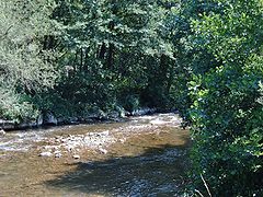
The Kinzig at Schenkenzell

Confluence of the Kinzig (left) and Schiltach (right) in the village of Schiltach

The straightened and expanded Kinzig near Hausach . Typical appearance from here to the mouth

Renatured bank area of the Kinzig near the Erlenbach estuary / Biberach
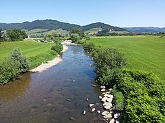
The Kinzig near Ortenberg , Großer Deich


Tributaries
In the Black Forest, many tributaries flow into the Kinzig, including several larger ones with lengths of 20-30 km, which mainly reach the Kinzig from north and south. 10 km or more in length (with indication of length and catchment area):
- Kleine Kinzig , from the right at the Schenkenzeller railway bridge, 20.2 km and 62.9 km²; longer and richer in water than the Kinzig at the confluence
- Schiltach , from the left in Schiltach , 29.5 km and 115.8 km²
- Wolf or Wolfach , from the right in Wolfach , 30.8 km and 129.6 km²
- Gutach , from the left at Gutach (Black Forest Railway) , 29.3 km and 161.5 km²; just before the Wolf, the most water-rich tributary of the Kinzig
- Mühlbach or Welschensteinacher Bach , from the left near Steinach , 10.5 km and 24.9 km²
- Erlenbach , from the right near Biberach , 18.9 km (together with the somewhat larger left Harmersbach of its two much longer upper reaches Harmersbach and Nordrach ) and 102.9 km²
- Schutter , from the left in the Upper Rhine Plain near Kehl , 56.8 km and 338.2 km²; by far the longest tributary, the Kinzig only reaches shortly before its mouth.
Places on the Kinzig
(in flow direction)
in the Freudenstadt district :
- Lossburg
- Alpirsbach- Ehlenbogen
- Alpirsbach
- Thigh cell
- Schiltach
- Schiltach fiefdom
in the Ortenau district :
- Wolfach- Kinzigtal
- Wolfach
- Wolfach- Kirnbach
- Hausach
- Fischerbach
- Haslach in the Kinzigtal
- Steinach
- Biberach (Baden)
- Gengenbach
- Berghaupten
- Ohlsbach
- Ortenberg (Baden)
- Offenburg
- Willstätt
- Throat
Flora and fauna
vegetation
The Kinzig valley has the deepest valley floor in the inner Black Forest. In the front Kinzig valley, the places are less than 200 meters above sea level. The climate in the Kinzig valley is therefore milder than in most other areas of the Black Forest. Fruit and wine are produced in the front Kinzig valley ; the vineyards of Gengenbach, Ortenberg and Ohlsbach are partly touched by the Baden Wine Route . The valley landscape around the Kinzig turns green much earlier in spring than the surrounding landscapes of the Black Forest.
Wildlife
Since 2002 attempts have been made to reintroduce salmon in the Kinzig by releasing young salmon and removing obstacles. At the beginning of 2005, salmon spawn was found again in a river in Baden-Württemberg for the first time in 50 years . In 2011 the salmon spawning game near Willstätt in the Kinzig was observed for several days. The following fish species can now be found again in the Kinzig:

- Atlantic salmon
- Rainbow trout
- Brown trout
- Barbel
- chub
- loach
- eel
- hazel
- minnow
- Brook trout
- Grayling
- roach
- Rudd
- cutter
- Brook lamprey
- Gudgeon
On the importance as a traffic and trade route
Rafting craft

The Kinzig was of great importance for rafting in earlier times . The earliest mention of this craft on the Kinzig comes from the year 1339 . The rafting towns of Wolfach and Schiltach had their own rafting companies that organized rafting up to the Rhine and on to Holland, the so-called shipships. They received the sole right to export wood from the respective sovereigns - a lucrative business that helped the cities to prosperity. Sebastian Münster writes in his Cosmographia universalis : "The people who live near the Kyntzig, especially around Wolfach, feed themselves with large Bawholz, which they float through the water of Kyntzig to Strasbourg into the Rhine and conquer a lot of Gelt every year" . Rafting experienced its heyday on the Kinzig in the 15th and 16th centuries and then again in the 18th century, when the demand for wood increased rapidly as the Netherlands and England began to build up their powerful war and merchant fleets. However, one could not keep up with the possibilities of the newly introduced railway, and so the last raft built for trade reasons drove on the Kinzig in 1896 . Even today, rafting festivals, rafting museums in Gengenbach , Wolfach and Schiltach, as well as numerous technical systems such as weirs, remind us of this time.

In Schiltach and Wolfach, rafting associations keep the memory of rafting alive and ensure that the technique of raft building is preserved for posterity.
The historic Roman road

The latitude, longitude and the favorable east-west course in the middle and lower valley make the Kinzig valley important for traffic management. So already talked Romans a road that ran through the valley: The Kinzigtalstraße is a Roman military road and was under the Roman Emperor Vespasian in the years 73 / 74 of Offenburg through the Kinzig Valley to simultaneously founded Roman Rottweil (Arae Flaviae) and on to Tuttlingen built. It was mainly intended to create a shorter strategic connection from Mainz to Augsburg, which until then had only run over the bend in the Rhine near Basel . During the Batavian revolt in 69/70 this detour had turned out to be a problem.
During the construction of this road several forts were built, next to Rottweil the camp in Offenburg-Rammersweier , Offenburg-Zunsweier, Castle Waldmössingen , Castle Sulz , Geislingen-Häsenbühl , and - as part of the Alblimes - the castles in Frittlingen , Castle Lautlingen and Castle Burladingen . The Burladingen camp was the only one of these facilities on Rhaetian territory, the other forts were Upper Germanic. The surprising discovery of the fort in Frittlingen in 1992 just a few kilometers south-east of Rottweil shows that the construction of the Kinzigtalstrasse was intensively secured with a dense network of military posts. The assumption that there was at least one other Roman fort in the Kinzig valley itself has thus acquired new plausibility. Until then, it was based only on the great distance between the castles in Offenburg and Waldmössingen, which suggested one or two other, previously undiscovered castles.
In Rottenburg , too , a Roman fort from the late 1st century is suspected, whether it was built as early as 73/74 or not until 98 AD is unknown.
Around the same time as the Kinzigtalstrasse was built, Roman forts east of the Rhine were built further north, for example in Frankfurt (?), Frankfurt-Heddernheim , Okarben , Groß-Gerau , Gernsheim (?), Ladenburg ( Lopodunum ), Heidelberg and Baden-Baden ( Aquae). It is so far unclear whether these are rather individual outposts or whether the border of the Roman Empire between approx. 73 and 98 AD generally ran along a clearly defined line east of the Rhine.
Presumably from the year 98 , today's southwest Germany up to the Odenwald and the Neckar became Roman. The connection Mainz-Augsburg was shortened further and the Kinzigtalstraße lost its national importance.
Traffic (today)
Today the federal highway 33 runs parallel to the Kinzig from Offenburg . In the upper valley it branches off and follows the Gutach towards Villingen-Schwenningen . From Hausach the federal road 294 leads along the upper Kinzig in the direction of Freudenstadt .
Most of the places and towns in the Kinzig Valley that are also of great tourist interest are now largely freed from through traffic through bypass roads and tunnels; the drive through the valley no longer stops thanks to the bypasses.
The railway also uses the valley's natural traffic axis. The Black Forest Railway runs from Offenburg to Hausach; there it bends into the Gutach Valley and then continues to Constance on Lake Constance . Through the upper Kinzigtal connects the Kinzig Valley Railway Hausach with joy city.
Castles, monasteries and palaces on the Kinzig
- Castles, monasteries and palaces
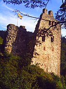
Schenkenburg near Schenkenzell

Wolfach Castle
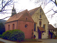
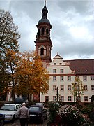
Monastery church and Loretto chapel of the Capuchin monastery in Haslach, February 2006

Hohengeroldseck ruins
Gengenbach Monastery

Ortenberg Castle in May 2008


- Alpirsbach Abbey , Alpirsbach
- Schenkenburg , Schenkenzell
- Schiltach Castle , Schiltach
- Willenburg , Schiltach
- Wolfach Castle , Wolfach
- Husen Castle , Hausach
- Capuchin monastery Haslach , Haslach
- Hohengeroldseck Castle , between Seelbach and Biberach (Baden)
- Gengenbach Monastery , Gengenbach
- Ortenberg Castle , Ortenberg (Baden)
See also
literature
- Emil Imm (Ed.): Land around Kinzig and Rench . Rombach, Freiburg 1974, ISBN 978-3-7930-0241-3
- Kurt Klein: Life on the River . 2nd Edition. Lehmann, Heidelberg 2002, ISBN 978-3-922663-75-1
- Alfred Stalf: Correction and entertainment of the Kinzig . In: The Ortenau. Journal of the Historical Association for Mittelbaden , 19. Offenburg, 1932, pp. 124–144. Freiburg historical holdings - digital, Freiburg University Library (Vol. 19/1932)
- Arnold Nauwerck: The salmon catch in the Kinzig . In: The Ortenau. Journal of the Historical Association for Middle Baden , 66. Offenburg, 1986, pp. 499-525. Freiburg historical holdings - digital, Freiburg University Library (Vol. 66/1986)
- Thomas Fleischhacker: The Kinzig before the expansion. Image of a wild river from historical maps . In: The Ortenau. Journal of the Historical Association for Mittelbaden , 90. Offenburg, 2010, pp. 283–288. Freiburg historical holdings - digital, Freiburg University Library (Vol. 90/2010)
Web links
- Gengenbach rafting museum
- People by the river - stories from the upper Kinzig valley
- Kinzigtal: Stories about the Kinzigtal
- The Kinzig path: a walk through the history of the river
- Portrait of the Black Forest Kinzig valley with a film on Fahr mal hin, SWR television
Individual evidence
- ↑ a b According to the State Institute for the Environment Baden-Württemberg (LUBW) ( information ), data and map service, digital terrain model of the online waterway map.
- ↑ According to the State Institute for the Environment Baden-Württemberg (LUBW) ( information ), data and map service, water network.
- ^ According to the State Institute for the Environment Baden-Württemberg (LUBW) ( information ), data and map service, aggregated areas 03.
- ^ German Hydrological Yearbook Rhine Region, Part I 2009 State Institute for Environment, Measurements and Nature Conservation Baden-Württemberg, p. 86, accessed on January 22, 2016 (PDF, German, 1.85 MB).
- ↑ a b Geoportal Baden-Wuerttemberg: LUBW service flowing waters - discharge parameters ( memento of the original from December 28, 2017 in the Internet Archive ) Info: The archive link was inserted automatically and has not yet been checked. Please check the original and archive link according to the instructions and then remove this notice. As of January 23, 2018
- ↑ Main State Archives Stuttgart (HStAS): A 470 U 1
- ↑ State Archives Sigmaringen (StAS) Dep. 39 HH / U 582
- ↑ Main State Archives Stuttgart (HStAS): A 470 Bü 73
- ↑ Main State Archives Stuttgart (HStAS): H 102/63, vol. 39, p. 3b
- ↑ Main State Archives Stuttgart (HStAS): H 102/2, Vol. 10, p. 19a
- ↑ Main State Archives Stuttgart (HStAS): H 102/2, Vol. 10, pp. 25b, 26a
- ↑ Main State Archives Stuttgart (HStAS): H 102/2, vol. 25, p. 108b
- ↑ Main State Archives Stuttgart (HStAS): H 102/63, Bd. 42, p. 4a
- ↑ Main State Archives Stuttgart (HStAS): H 102/63, Bd. 43, p. 3b
- ↑ Main State Archives Stuttgart (HStAS): H 102/63, Bd. 31, S, 42a
- ↑ Main State Archives Stuttgart (HStAS): H 102/63, Bd. 44 :, pp. 19a, 20b
- ↑ primary cadastre
- ^ A b Adolf Bach: German onomastics. Vol. II / 2, Heidelberg 1981, p. 438.
- ^ Bruno Boesch: Small writings on name research. Heidelberg 1981, p. 266.
- ^ Bruno Boesch: Small writings on name research. Heidelberg 1981, p. 280.
- ↑ Michael Richard Buck: Upper German field names book. Stuttgart 1880, p. 130.
- ↑ Ludwig Traub: Württemberg river names from prehistoric times in their meaning for the local early history. In: Württembergische Vierteljahrshefte für Landesgeschichte , XXXIV. Year, 1928, Stuttgart 1929, p. 16.
- ↑ Hans Krahe: Our oldest river names. Wiesbaden 1964.
- ^ Walther Keinath: Place and field names in Württemberg. Stuttgart 1951.
- ↑ Otto Springer: The river names of Württemberg and Baden. Stuttgart 1930, pp. 53, 60.
- ^ Wilhelm Obermüller: German Celtic Dictionary. 1872, reprint print, Vaduz 1993, vol. II, p. 178 f.
- ^ Hans Bahlow: Germany's geographical world of names. Frankfurt 1985, p. 263.