
Gutach (Kinzig)
| Expert | ||
_-_geo-en.hlipp.de_-_12735.jpg) The Gutach in Hornberg |
||
| Data | ||
| Water code | EN : 2344 | |
| location | Baden-Württemberg | |
| River system | Rhine | |
| Drain over | Kinzig → Rhine → North Sea | |
| source | 3½ km east-southeast the center of Schoenwald in the Black Forest Good forest 48 ° 5 '52 " N , 8 ° 14' 52" O |
|
| Source height | approx. 1001 m above sea level NN | |
| muzzle | east of the municipal boundary of Hausach from the left and south into the Kinzig coordinates: 48 ° 17 ′ 6 ″ N , 8 ° 11 ′ 51 ″ E 48 ° 17 ′ 6 ″ N , 8 ° 11 ′ 51 ″ E |
|
| Mouth height | approx. 244 m above sea level NN | |
| Height difference | approx. 757 m | |
| Bottom slope | approx. 26 ‰ | |
| length | 29.3 km | |
| Catchment area | 161.544 km² | |
| Discharge at the Gutach A Eo gauge : 146 km². Location: 5.35 km above the mouth |
NNQ (09/04/1991) MNQ 1981-2010 MQ 1981-2010 Mq 1981-2010 |
210 l / s 700 l / s 4.09 m³ / s 28 l / (s km²) |
| Discharge at the mouth of the A Eo : 161.5 km² |
MQ Mq |
4.45 m³ / s 27.6 l / (s km²) |
The Gutach is an approximately 29 kilometer long tributary of the Kinzig in the center of the Middle Black Forest in Baden-Württemberg .
Neighboring waters with the same name
Only a few kilometers southwest of the Gutach, the Wilde Gutach , also called Gutach alone , flows through the Simonswälder Valley and then into the Elz near Gutach im Breisgau . Another Bach Gutach of the same name flows from the Titisee into the Wutach Gorge .
Course and characteristics
The headwaters of the Gutach are located in the district of Schönwald , inserted between those of the two Danube source rivers Brigach (about 2.5 kilometers to the east) and Breg (about 6.5 kilometers to the west). Unlike this one, it does not drain south-east over the Danube into the Black Sea, but north over the Kinzig and the Rhine to the North Sea. The southern border of their catchment area is part of the European main watershed . Because of the deep erosion base of the nearby Rhine, its valley in the middle and lower reaches is steep and deeply cut into the partly plateau-like, partly hilly mountainous landscape.

Headwaters of the Gutach in the Hochmulden near Schönwald
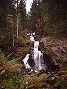
Waterfalls in the Triberg valley basin
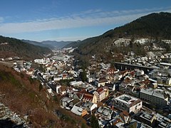
Lower Gutach Valley near Hornberg


From numerous source streams on the Schönwalder high plateau, the Gutach forms a powerful stream before it plunges 163 meters into the Triberg basin in ten larger steps . These Triberg waterfalls are among the ten highest in Germany. Then it flows through a winding narrow valley to Hornberg and then through a broader, almost straight valley with still steep slopes, only to flow into the Kinzig just above Hausach . She passes through Gutach and the Vogtsbauernhof open-air museum .
The Black Forest Railway and federal road 33 run through the Gutach valley . This makes the Gutach one of the most important traffic axes in the Black Forest. The economy of the Gutach valley is characterized by numerous larger wood processing companies and small-scale precision engineering. Even after the construction of the Black Forest Railway, tourism developed here early on.
The lowest section of the valley is known for its traditional costume with the eye-catching Bollenhut .
Tributaries
Water lengths and names according to LUBW-FG10, size of the catchment areas according to LUBW-GEZG. Selection.
Origin of the Gutach about 3.6 km east-southeast of the center of Schönwald in the Black Forest in the Gutenwald on the edge of a high-voltage aisle , a stone's throw southeast of a small pond.
- Tiefenbach , from the left towards the homonymous homestead, 1.5 km.
- Schönbächle , from the left in front of the Kienzlerhansenhof, 1.5 km and 1.2 km².
- Baslertalbach , from the left at Stampferhöfle, 1.6 km and 1.2 km².
- Inflow from the Straßwald , from the left east of Schönwald itself, 2.6 km and 2.5 km².
- Feeds a lake near Hölltal, 1.6 ha.
- Schwarzenbach , from left to the lake, 3.9 km and 6.9 km².
Transfer to the urban area of Triberg in the Black Forest .
- Plunge down the Triberg waterfalls .
- Mosenbach , from the right in Triberg an der Schulstrasse (verdolt), 3.3 km.
- Schonach , from the left in Triberg between Riffhaldenweg and Hauptstraße, 5.5 km and 10.0 km².
- Nussbach , from the right in Triberg on Bahnhofstrasse, 6.4 km and 15.9 km².
Short transfer to the area of the community of Schonach in the Black Forest
- Alpirsbach , from the left on the border of Schonach and Triberg again, 1.9 km.
Transfer back to Triberg city area
- Gremmelsbach , from the right in the Untertal district in front of the sewage treatment plant, 4.2 km and 9.0 km².
- Losbach , from the left below the sewage treatment plant, 1.9 km and 1.6 km².
- Hippensbach , from the left at the city limits to Hornberg , 1.1 km and 0.8 km².
Transfer to the urban area of Hornberg
- Obergießbach , from the left in the Hornberg district of Am Bach, 4.4 km and 7.3 km².
- Lindendobelbach , from the right in Am Bach, 0.6 km.
- Althornbergbach , from the right past the Hornberg-Niederwasser quarry, 2.1 km.
- Niedergießbach , from the left after the valley widening before the Niederwasser district, 6.2 km and 7.6 km².
- Frombach , from left to Niederwasser in front of the bath, 2.6 km and 2.7 km².
- Rubersbach , from the right opposite the sports field 0.9 km and 0.6 km².
- Immelsbach , from the right near Hans-Thoma-Strasse, 0.9 km and 0.8 km².
- Exit on the left side of the commercial canal at the southern mouth of the tunnel on federal highway 33 .
- Offenbach , from the left along Schloßstraße into the commercial canal , 3.7 km and 3.7 km².
- Return of the commercial canal after the main road bridge, 0.8 km.
- Reichenbach , from the right along Poststrasse, 8.3 km and 31.8 km².
Transfer to the municipality of Gutach (Black Forest Railway)
- Wonnenbach , from the left near Blumbach, 1.7 km and 1.5 km².
- Riesenbach , from the right across from Blumbach into a short Mühlkanal, 1.1 km.
- Ebersbach , from the right at Vor Ebersbach, 1.0 km and 1.0 km².
- Steinenbach , from the left opposite Steingrün, 4.3 km and 7.0 km².
- Bühlerbächle , from the right opposite Säge, 1.3 km.
- Sulzbach , from the left opposite the island, 3.4 km and 4.9 km².
- Ramsbach , from the right, 2.0 km.
- Herrenbach , from the left at Herrenbach, 1.6 km.
- Wellersbach , from the left at the electoral offices, 1.6 km.
- Saumerbach , from the left at the Saumerhöfen, 1.6 km and 0 km².
Mouth of Gutach from the left and south into the Kinzig at Breithauptshof the community Gutach (Schwarzwaldbahn) , just east of the municipal boundary of Hausach and its main settlement.
Localities
Places on the Gutach from the source to the mouth. Selection.
- Community of Schönwald in the Black Forest
- Auf'm Bühl (living space, left)
- City of Triberg in the Black Forest
- Triberg in the Black Forest (main town)
- Community of Schonach-Bach
- At the brook (living space)
- City of Triberg
- Gremmelsbach district , Am Bach (Zinken)
- City of Hornberg
- Low water (brook, left)
- Hornberg (main town)
-
Gutach (Black Forest Railway)
- Stone green (living space)
- Gutach (village)
- At the Mattenbauernhof (settlement, left)
Attractions
- Triberg waterfalls
- Black Forest Railway
- Vogtsbauernhof open-air museum
- Open-air theater in Hornberg ( Hornberger Schießen )
Individual evidence
- ↑ a b According to the contour line image on the background map of the LUBW-FG10.
- ↑ According to LUBW-FG10.
- ↑ Sum of the sub-catchment areas according to LUBW-GEZG (data type entries).
- ^ Flood forecast center , State Institute for the Environment Baden-Württemberg
- ↑ Gutach water level , increased by the area runoff (around 25 l / s km²) of the remaining catchment area (15.5 km²)
- ↑ After the polygon of the LUBW-FG10. On the background map, two half-kilometer watercourses from the forest come together at this point, which arise further uphill in the southeast.
Web links
- Geoportal Baden-Württemberg ( information ), especially with the partial maps / layers
- the State Institute for the Environment, Measurements and Nature Conservation Baden-Württemberg (LUBW)
- "LUBW-FG10": River 1: 10,000
- "LUBW-SG10": Standing water 1: 10,000
- "LUBW-GEZG": water catchment areas
- "LUBW-SCHUTZ": Various cards for the individual nature conservation categories
- of the State Office for Geology, Raw Materials and Mining of the State of Baden-Württemberg (LGRB)
- "LGRB-GTP": Geotope cadastre
- "LGRB-GÜK300": Geological overview map 1: 300,000