Sulzbächle (Kinzig)
| Sulzbächle | ||
|
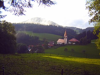
In the Sulzbächletal in St.Roman, in the background in the fog the Staufenkopf |
||
| Data | ||
| Water code | DE : 234314 | |
| location |
Baden-Württemberg
|
|
| River system | Rhine | |
| Drain over | Kinzig → Rhine → North Sea | |
| origin | Pond outlet east below the Staufenkopf 48 ° 20 ′ 15 ″ N , 8 ° 17 ′ 7 ″ E |
|
| Source height | approx. 688 m above sea level NN | |
| muzzle | to Wolfach -St. Roman in die Kinzig coordinates: 48 ° 17 ′ 29 " N , 8 ° 17 ′ 45" E 48 ° 17 ′ 29 " N , 8 ° 17 ′ 45" E |
|
| Mouth height | approx. 302 m above sea level NN | |
| Height difference | approx. 386 m | |
| Bottom slope | approx. 65 ‰ | |
| length | 5.9 km | |
| Catchment area | 7.51 km² | |
The Sulzbächle is a 6 km long brook in the central Black Forest in the area of the town of Wolfach in the Ortenau district of Baden-Württemberg , which flows from the right into the central Kinzig after a consistently southern course between the towns of Schiltach and Wolfach .
geography
course
The Sulzbächle rises near east below the Staufenkopf ( 849.2 m above sea level ) and near southwest below the Spitzkopf ( 829.8 m ) in the Wolfacher district Kinzigtal -St. Roman at about 688 m a small pond at Klausenhansenhof. After a short south-easterly run on a moderate gradient, the stream reaches the center of the mountain village of St. Roman, an idyllic Black Forest village surrounded by fir trees with lush hills and mountain meadows. There it turns permanently to the south and cuts its way more steeply. After the stream has passed the Graefenhof that soon follows, the forest stretches down to the valley floor for a long time.
Only a little before the Sulzbächle residential area about two thirds of the way down does the valley floor open up again. At the residential area the only larger tributary stream flows in from the left, the 1.5 km long Fischbach , which contributes about 1.1 km² to the catchment area. There are two more groups of houses in the Sulzbächle residential area in the Kerbtal, which remains open until the end, then the Sulzbächle flows under it and 5.9 km down from its origin at the St. Roman stop of the Kinzig Valley Railway from the right and north at about 302 m in the middle Kinzig on their westward stretching section between Schiltach and Wolfach.
Catchment area
It covers 7.5 km² and extends about 5.5 km from the summit of the Spitzkopf straight south to the mouth; across it does not reach a width of 2 km anywhere. Beyond the highest and short watershed in the north - the summit of the Staufenkopf is the highest point in the catchment area - short streams drain to the Wolf , which flows far down into the Kinzig. Behind the long eastern divide, the Heubach runs parallel to the upward Kinzig; the catchment area of Ippichenbach , on the other hand, adjoins the right watershed and, in the far north, Langenbach , which reaches the Kinzig between Sulzbächle and Wolf.
history
Sulzbächle in the lower section of the valley used to be an exclave , as was the nearby Konradshof, which formerly belonged to the village of Lehengericht , but was first transferred to Schiltach in 1874. This whole area was then given to the city of Wolfach in 1979. However, the residents continue to cultivate the customs of the feudal judges, so people still wear the feudal judges' costume here .
tourism
The Sulzbächle is a popular holiday and weekend destination because of the village of St. Roman with its gastronomy and scenic beauty. The Hansjakobweg I circular hiking trail leads through the upper valley and the village of St. Roman .
Individual evidence
- ↑ a b Height according to the contour line image on the background layer Topographic map of the online map server of the State Institute for the Environment, Measurements and Nature Conservation Baden-Württemberg (LUBW). See the → web links .
- ↑ a b Length according to the water network layer ( AWGN ) of the LUBW's online map server.
- ↑ Catchment area according to the basic catchment area (AWGN) layer of the LUBW's online map server.
- ↑ Catchment area measured on the background layer topographic map of the LUBW's online map server.
literature
- Topographic map 1: 25,000 Baden-Württemberg, as single sheet No. 7615 Wolfach and No. 7715 Hornberg
