
Alexanderschanze
| Alexanderschanze | |||
|---|---|---|---|
 Hotel Alexanderschanze |
|||
| Compass direction | west | east | |
| Pass height | 970.8 m above sea level NHN | ||
| state | Baden-Württemberg | ||
| Valley locations | Oppenau | Freudenstadt | |
| expansion | Pass road | ||
| Mountains | Black Forest | ||
| Map (Baden-Württemberg) | |||
|
|||
| Coordinates | 48 ° 28 '51 " N , 8 ° 16' 35" E | ||

Alexanderschanze is a pass (height 970.8 m above sea level ) on the federal road 28 near Freudenstadt in the northern Black Forest . At the same time there is the Alexanderschanze fortress and finally the Hotel Alexanderschanze.
Pass Alexanderschanze
The pass lies between Freudenstadt-Kniebis , Bad Peterstal-Griesbach , Oppenau and Baiersbronn and offers a connection between the Rhine plain near Strasbourg and the Neckar valley , which allows the Black Forest to be crossed in a west-east direction without further major valley crossings and pass climbs. To the north of today's modern Kniebis – Freudenstadt road, which runs largely in the Forbachtal, there are the signs “Alte Straße” and even “Römerstraße”. Even if there are no reliable sources according to which the Romans built this road, the use of the pass as a long-distance path in the early Middle Ages can be assumed to be safe, as the track tracks in the forest prove. In this context, track means the grooves that can still be seen in the rock today, which were left by the wooden wheels shod with steel bands.
Alexanderschanze fortress
According to Stälin , the Strasbourg bishop Johann von Dirpheim (bishop from 1306 to 1328) had fortifications built on Kniebis. In 1655 there were already jumps at this point. The location of this fortification is documented in detail for the first time on the map by Stäbenhaber from 1674.

The comment on the card “2. Schanz, repaired on November 9, 1674 “also proves that older systems must have been present. Stäbenhaber himself managed the construction work in 1674 and 1675. The 2. Schanz ”consisted of two simple rectangular jumps, according to Stäbenhaber. With them the path coming from Oppenau - refuge through the raised bog could be blocked.
From 1710 to 1712 the ski jump was rebuilt under the direction of Lieutenant Reichmann. He designed the plant completely new: two redoubts, right and left abatis , between the two redoubts, the road leads through, which could be additionally locked with a gate.
It was given the name Alexanderschanze in 1734 when Duke Karl Alexander von Württemberg had the existing entrenchments modernized in order to secure the strategically important crossing point on the Württemberg border. The engineer from Herbort directed the work.
In 1796 additional extensions were made by French troops. During the Second Coalition War from 1799 to 1801, the front between Austrian and French troops ran here at times .
The two jumps are shown in detail on a field map from the 19th century, including the trenches protruding far to the northwest and the trenches between the two jumps in the form of another similar jump.
State of the jumps

The ski jump north of the Alexanderschanze hotel is extremely well preserved.
Height of the trench bottom to the top of the whale 4–5 m, height of the interior to the top of the whale 2–3 m. The wall is interrupted at the northwest corner, i.e. in the direction of Oppenauer Steige. In the interior at the southeast corner, a large pile of rubble and earth indicates building remains. The ski jumping facility is easily accessible.
The ramparts of the opposite hill west of the hotel are lower (2 m, sometimes less) and damaged. The walls and interior are heavily overgrown and difficult to access.
There are few detectable traces of the previously existing trenches. Only at the ski jump opposite the hotel is a 20 m long section well preserved. It leads from the north corner towards NNW, i.e. towards refuge.
Hotel Alexanderschanze
The listed hiking hotel Alexanderschanze at the top of the pass goes back to a forester's house from 1868. This burned down in 1911 and was replaced by the building that still exists today. The hotel has been closed since January 1st, 2015.
Bunker from the Second World War near the Alexanderschanze
Shortly before 1940, new security systems were built as part of the western wall . The simultaneous expansion of the Black Forest High Road ( B 500 ) from Ruhestein also had military reasons. In the nearby Tannenberg headquarters , Adolf Hitler stayed for only one week in the summer of 1940.
After 1945 all bunkers in this area were blown up and the areas reforested. Today the spruce forest and the remaining soil monument form the 190 hectare Kniebis-Alexanderschanze nature reserve southeast of the Schliffkopf .

Detail of the map by Prelate Johann Mayer, Murrhardt, 1712

Postcard from the Alexanderschanze from 1899
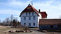
Hotel Alexanderschanze
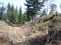
eastern redoubt, opposite the hotel

the less well-preserved western redoubt of the Alexanderschanze

.jpg)


Individual evidence
- ↑ Map services of the Federal Agency for Nature Conservation ( information )
- ↑ Topographic map No. 7515 Oppenau, from the State Surveying Office Baden-Württemberg, ISBN 978-3-89021-158-9 .
- ↑ Hiking map 1: 50,000 Bad Wildbad Freudenstadt, from the Land Surveying Office Baden-Württemberg, ISBN 3-89021-499-1 .
- Jump up ↑ magazine “Schöne Schwaben”, issue 7/2004, p. 24.
- ↑ Dieter Kapff and Reinhard Wolf : "Stone crosses, boundary stones, signposts ..." Theiss-Verlag, ISBN 3-8062-1460-3 , page 67.
- ↑ see photo by Thomas Horn http://www.ilya.it/chrono/dtpages/gleisedt.neu.html#HornGleisKniebis
- ^ Christoph Friedrich von Stälin: Württembergische Geschichte III, p. 95.
- ^ Manfred Eimer: History of the City of Freudenstadt , Verlag Oskar Kaupert, Freudenstadt, 1937, p. 153
- ^ Map by Georg Ludwig Stäbenhaber (also Stebenhaber) from 1674, source Landesarchiv Baden-Württemberg, Hauptstaatsarchiv Stuttgart [1] .
- ↑ Manfred Eimer: Zu Kniebis auf dem Walde, historical summary about the Kniebis and the Kniebis baths, Erwin Schmieder's printing and publishing house, Baiersbronn, 1954
- ^ Walter Kull: Freudenstädter contributions to the historical regional studies, volume "fortress Freudenstadt" p. 103., publisher: Heimat- und Museumsverein für Stadt und Kreis Freudenstadt eV, 1985
- ↑ Land map from 1837–1856.
See also
literature
- Manfred Eimer: Zu Kniebis auf dem Walde, historical summary about the Kniebis and the Kniebis baths, Erwin Schmieder's printing and publishing house, Baiersbronn, 1954
- A. Hiss: Der Kniebis and the Kniebisbäder today, Erwin Schmieder's printing and publishing house, Baiersbronn, 1954
- Map "Actual ground plan of the Freudenstadt forest with its curly marrow and boundary stones, made by Johann Mayer, Prelate of Murrhardt ann 1712" http://www.landesarchiv-bw.de/plink/?f=1-1391525
Web links
- Map of the historical entrenchment in August Meyer: Notes on the stretch of land between Lake Constance and Pfinz, thoughts on the fortification of the border between southern Germany and France . 1819. Digitized version of the Baden State Library .