
Knee to

The Kniebis is an elongated mountain ridge up to 971 meters high in the Black Forest and a village in the southern part of it. This scattered settlement is now part of Freudenstadt .
traffic
The Kniebis is on the Black Forest High Road , which comes as the B 28 from Freudenstadt and continues from the Alexanderschanze pass as the B 500 to Baden-Baden . The B 28 itself continues to Kehl and Strasbourg . The state road 96 leads south towards Hausach . The Kniebis is connected to the Freudenstadt bus service.
tourism
In winter there are numerous cross-country trails , u. a. also a floodlit / night trail that can be snow-covered, and several lifts in the village or in the immediate vicinity (Vogelskopf, Zuflucht , Kniebis ski lifts ); there is also a toboggan run and various winter hiking trails. In summer the Kniebis presents itself as a large mountain bike, Nordic walking and hiking area; there is also an outdoor forest swimming pool that was completely renovated only a few years ago. A nearby destination is the Lothar path on the Schwarzwaldhochstrasse (Bundesstrasse 500) in the direction of Schliffkopf . At the western end of the village is the Alexanderschanze , further north the Röschenschanze and the Schwedenschanze can be visited.
economy
The place lives mainly from tourism . As winter sports more are ski lifts (approximately 100 meters in altitude ), many kilometers of groomed trails and a toboggan run available. The so-called night trail in the Kniebis ski stadium (subject to a fee), an approx. 2 km long circuit in the immediate vicinity, is floodlit in appropriate weather conditions and can be completely covered with artificial snow.
climate
| The annual precipitation is 1886 mm. The precipitation is in the upper third of the measuring points of the German Weather Service , over 99% show lower values. The driest month is September; the greatest amount of precipitation occurs in January. In the wettest month, around 1.4 times more water falls to the ground than in the driest month. The seasonal fluctuations are in the upper third. In over 89% of all places, the monthly precipitation fluctuates less. |

education
Kniebis has a kindergarten and a primary school. The elementary school has another special structural feature: It is attached directly to the Protestant church.
In addition, the European Theological Seminar (ETS) is located in Kniebis , which offers study opportunities in the field of theology.
history
In the early modern times , the Kniebis was an important obstacle on the long-distance trade route Strasbourg - Ulm (so-called Oppenauer Steige) due to its incline from Oppenau up to the Kniebis Pass summit. This trade route (also Schwabenweg) was operated by the family of Zähringer at the time of the Staufer. Later he formed an important link between Württemberg and the Württemberg possessions in what is now France . During wartime, for example in the Thirty Years War , it was also used for troop movements.
After the rule of the Hohenstaufen dynasty around 1250, the border between the holdings of the Principality of Fürstenberg (which became part of the Grand Duchy of Baden in 1806 ) in the Kinzig Valley and the Middle Black Forest as well as the Duchy and later Kingdom of Württemberg ran on the Kniebis .

In 1267 the Kniebis Monastery was founded in Kniebis-Dorf (Kniebis in Württemberg) , which was dissolved as a result of the Reformation in 1534.
The pass over the Kniebis was very important as a trade route between the Rhine Valley and Württemberg early on, and in the Middle Ages it was also strategically important from a military perspective. Therefore, several fortifications were built in the area of Kniebis and the Black Forest High Road north of it.
- On the mountain top at the exit of the village, the so-called "Kleine Schanz" (also called "Alte Schanz") was built in 1632 between the boundary stones 52 and 53 on the road leading to the pass, so that one had control over the road. No reliably traceable remains are visible, only a notice board on the street opposite the new Kniebis Hut indicates this.
- About 1 km northwest of it on the Black Forest High Road (B500) is the Alexanderschanze . On Stäbenhaber's map from 1674, it is already referred to as “repaired”, so it is even older.

- Another 3 km further on the Black Forest High Road at the junction to Oppenau is the Schwedenschanze , it was first mentioned in 1593.
- In the immediate vicinity of the Schwedenschanze, the Röschenschanze named after him was finally built in 1794 by Major Rösch .
The Kleine Schanz (1), the Alexanderschanze (2) and the Schwedenschanze (3) are marked on the section of the map from Stäbenhaber.

From 1939 (start of construction) to 1945 (demolition by the German Wehrmacht), the Fuehrer's headquarters in Tannenberg was located on the mountain , which was also used as such by Adolf Hitler in 1940 for a short time. From July to the end of 1941 Gestapo prisoners from the labor education camp (AEL) Kniebis-Ruhestein worked on the construction of a section of the Black Forest High Road. Both locations belonged then as now to the municipality of Baiersbronn, since the newly delimited urban area of Freudenstadt only extends to the part in the south where there are residential buildings, including Alexanderschanze.
From ancient times the Kniebis consisted of three parts, the Baiersbronn part, the Freudenstadt part (both parts together formed the Württemberg Kniebis) and the Baden Kniebis, which belongs to Bad Rippoldsau . The border is still marked today by boundary stones on the Grenzweg . Due to the different political affiliations between the Württemberg and Baden Kniebis, an inner Alemannic dialect between Swabian and Upper Rhine Lower Alemannic has developed.
On January 1, 1975, the districts belonging to Baiersbronn and Bad Rippoldsau-Schapbach were reclassified to Freudenstadt.
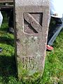
Baden side of a boundary stone on the Grenzweg

Württemberg side of a boundary stone on the Grenzweg


See also
Individual evidence
- ^ Map by Georg Ludwig Stäbenhaber (also Stebenhaber) from 1674, source Landesarchiv Baden-Württemberg, Hauptstaatsarchiv Stuttgart [1] .
- ↑ Ingrid Bauz, Sigrid Brüggemann, Roland Maier (eds.): The Secret State Police in Württemberg and Hohenzollern. Stuttgart 2013, pp. 148f., ISBN 3-89657-138-9 .
- ^ Federal Statistical Office (ed.): Historical municipality directory for the Federal Republic of Germany. Name, border and key number changes in municipalities, counties and administrative districts from May 27, 1970 to December 31, 1982 . W. Kohlhammer, Stuttgart / Mainz 1983, ISBN 3-17-003263-1 , p. 492 .
literature
- Louise Pichler, The Settlers in the Black Forest . Verlag Otto Risch, Stuttgart around 1890. ( Stories for the youth and the people , Volume 15, 2nd edition)
- Ralf Bernd Herden : The court of the Führer Headquarters (on the knee). In: Die Ortenau, 93rd annual volume 2013, pp. 443–452
- Ralf Bernd Herden: The “Führer Headquarters Tannenberg” on the Kniebis. In: Martin Ruch (Ed.): The Ortenau. Publications of the Historical Association for Central Baden. 82nd annual volume 2002, Bühl 2002, pp. 681–684.
- Adolf J. Schmid : The Kniebis and his Catholic Church St. Josef: 1899–1999 . Schillinger, Freiburg im Breisgau 1999, ISBN 3-89155-243-2 .
- Eugen von Philippovich : The state-supported emigration in the Grand Duchy of Baden in Archives for Social Legislation and Statistics - Quarterly journal for researching the social conditions of the states , Berlin 1892, Fifth Volume, Pages 27-69, in particular pages 33 ff. Digitized
Web links
- Kniebis.de - the Black Forest village
- Kniebis in the regional information system LEO-BW
- Wintersport In: nationalparkregion-schwarzwald.de , accessed on April 26, 2020.
Remarks
- ↑ Georg Ludwig Stäbenhaber was born in Hetzlinshofen in 1640. From 1668 he worked under master builder Weiß at the fortress in Freudenstadt as an assistant and inspector. His most important work, however, is the map of the Freudenstädter Forst from 1675. Because of the high accuracy of the representation, this map is a valuable historical document today.

Dietersweiler with Lauterbad | Freudenstadt (core city) with Christophstal and Zwieselberg | Grüntal and Frutenhof | Igelsberg | Knee to | Musbach | Wittlensweiler
Coordinates: 48 ° 29 ' N , 8 ° 18' E