
Seewald
| coat of arms | Germany map | |
|---|---|---|

|
Coordinates: 48 ° 35 ' N , 8 ° 27' E |
|
| Basic data | ||
| State : | Baden-Württemberg | |
| Administrative region : | Karlsruhe | |
| County : | Freudenstadt | |
| Height : | 800 m above sea level NHN | |
| Area : | 58.5 km 2 | |
| Residents: | 2134 (Dec. 31, 2018) | |
| Population density : | 36 inhabitants per km 2 | |
| Postal code : | 72297 | |
| Primaries : | 07447, 07448 | |
| License plate : | FDS, HCH , HOR, WOL | |
| Community key : | 08 2 37 073 | |
| Community structure: | 7 districts | |
| Address of the municipal administration: |
Wildbader Strasse 1 72297 Seewald |
|
| Website : | ||
| Mayor : | Gerhard Müller | |
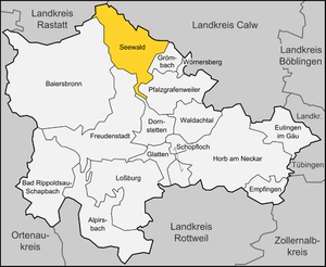
| Location of the municipality of Seewald in the Freudenstadt district | ||
  |
||

Seewald is a municipality in the Freudenstadt district in Baden-Württemberg . It belongs to the Northern Black Forest region .
geography
Geographical location
The Erzgrube district is located at the Nagoldtalsperre at around 550 m above sea level. NN . The highest district, Besenfeld, lies at 800 m above sea level. NN . Over 90% of the district is covered by forest areas. The Black Forest mountains in the municipality of Seewald rise up to 900 m above sea level. NN .
Waters
In the district Urnagold springs the Nagold , in the woods above broom box spring streams Cold, foliage and Poppel, which relate to the district Enzkloesterle to Enz combine.
Community structure
The municipality of Seewald consists of the seven districts Besenfeld (1115 inhabitants) with Urnagold (21 inhabitants) and Schorrental (west of Nagold, 24 inhabitants), Göttelfingen (445 inhabitants) with Schorrental (east of Nagold), Omersbach (north of Kropfbach) and Morgental, Hochdorf (154 inhabitants) and Omersbach (south of the Kropfbach), Erzgrube (166 inhabitants), Allmandle (53 inhabitants), Eisenbach (94 inhabitants) and Schernbach (124 inhabitants) with a total of 16 villages, hamlets, Zinken, farms and houses . (As of December 31, 2015) Seewald can therefore be clearly identified as a municipality with a large municipal area.
The spatial boundaries of the districts are those of the former communities or, in the case of Allmandle and Eisenbach, the built-up location of these places. In Seewald the false sub-town selection has been introduced, i. H. the electoral area in municipal council elections is divided into six residential districts in the sense of the Baden-Württemberg municipal code, which are identical to the districts with the exception that the districts Allmandle and Eisenbach are combined into one residential district.
Settlements that have passed and no longer exist today are Seehaus in the Besenfeld district and Glasehusen and Kropfmühle in the Göttelfingen district.

history
Besenfeld emerged as a clearing site in the High Middle Ages and belonged to the Count Palatine of Tübingen in the 13th century . Then the place came to the Counts of Eberstein , who sold the village in 1421 to the Counts of Württemberg . Until 1807 Besenfeld was under the Württemberg Office of Dornstetten.
Göttelfingen, also a result of clearing in the High Middle Ages, had become Baden in the late Middle Ages before it came to Württemberg through exchange in 1603. In 1778 a village fire destroyed the whole place. Until 1811, Göttelfingen belonged to the Altensteig office of Württemberg.
During the implementation of the new administrative structure in the Kingdom of Württemberg , which was created in 1806 , the four communities Besenfeld, Erzgrube, Göttelfingen and Hochdorf were gradually subordinated to the Freudenstadt District Office until 1812 . During the administrative reform during the Nazi era in Württemberg , the localities came to the Freudenstadt district in 1938. In 1945 the area became part of the French occupation zone and was thus assigned to the newly founded state of Württemberg-Hohenzollern in 1947 , which became part of the state of Baden-Württemberg in 1952.
Parish mergers
On December 1, 1971, Erzgrube, Göttelfingen and Hochdorf merged to form the new municipality of Seewald. Besenfeld merged with this on January 1, 1975 to form today's Seewald municipality.

Historical coat of arms from Erzgrube

Historical coat of arms of Göttelfingen
Historic coat of arms of Hochdorf

Historical coat of arms of Besenfeld


.png)

Religions
Seewald has been evangelical since the Reformation . Today there is one Protestant parish each in Besenfeld and Göttelfingen, which are combined to form the Seewald parish. In Besenfeld there is also an Evangelical Methodist and a New Apostolic congregation, while the local mission house of the Evangelical-regional church in Liebenzell is located in Göttelfingen . In Besenfeld the free church brothers' movement runs a leisure home. The nearest Roman Catholic church is in Baiersbronn .
The suburb of Göttelfingen became known nationwide after the local Protestant pastor announced on July 25, 2012 that he wanted to convert to the Roman Catholic Church and was therefore suspended from his pastoral service by the Evangelical Church in Württemberg on August 6, 2012. At about the same time, he published a book entitled, “Why Don't We Become Catholic? - Food for thought from an Evangelical Lutheran pastor. "
politics
Municipal council
The local election on June 13, 2004 resulted in the following distribution of seats:
| FWG | 83.6% | −16.4 | 13 seats | ± 0 |
| List of women | 16.4% | +16.4 | 2 seats | +2 |
In the following election on June 7, 2009, the women's list was able to increase its share of the vote. The distribution of seats and votes based on the election:
| United Seewald | 71.7% | −11.9 | 10 seats | −3 |
| List of women | 28.3% | +11.9 | 4 seats | +2 |
In the election on May 25, 2014, the women's list increased its share of the vote again. The current distribution of seats and votes:
| United Seewald | 63.9% | −7.8 | 10 seats | ± 0 |
| List of women | 36.1% | +7.8 | 5 seats | +1 |
The local elections on May 26, 2019 led to the following final result. The turnout was 63.1% (2014: 60.9%).
| United Seewald | 63.97% | 9 seats |
| List of women | 36.03% | 5 seats |
mayor
In 2007 Gerhard Müller was elected the new mayor from among five applicants. He was re-elected in 2015.
Party of faithful Christians
Seewald is a stronghold of the Biblical Christians Party (PBC), which received 5.0% of the second votes in the 2005 Bundestag election (national average: 0.2%), but only 1.1% in 2013 .
Economy and Infrastructure
traffic
Seewald is connected to the national road network by the federal road 294 ( Bretten - Freiburg im Breisgau ).
education
Seewald has its own primary school in the Besenfeld district. Attending secondary schools takes place in Freudenstadt . There is also a municipal kindergarten in Besenfeld , while there is a Protestant kindergarten in Göttelfingen .
Culture and sights
The district of Besenfeld is located on Mittelweg , a long-distance hiking route that leads past many sights. The entire community has a large network of cycling and hiking trails. Numerous kilometers of trails are groomed in winter. Besenfeld is connected to Kaltenbronn and Freudenstadt by a long-distance ski trail. Several snowshoe trails are also signposted, which can be used as Nordic walking routes in summer.

In addition, in the Erzgrube district, there is the Nagoldtalstausee , which attracts thousands of visitors, especially in the summer months, and is one of the biggest attractions in the Northern Black Forest. The lake dams the Nagold river, which rises in the Urnagold district, over a length of about three kilometers.
The church of St. John the Baptist in Urnagold was the parish responsible for Besenfeld, Göttelfingen and Hochdorf since the Middle Ages. In 1754, instead of the old fortified church, a new church interior was built on the Gothic tower. In the basement of the tower there is a hall spanned by a net vault, in which there is an old stone altar. In the 19th century, Protestant parishes of their own were established in Göttelfingen and Hochdorf, so that the church in Urnagold fell out of use, but was renovated in 1959. The enclosed source of the Nagold can be found not far from the church .
Since May 2008, the Seewald community has been operating a quiet grove, a forest cemetery for alternative forms of burial under trees and on forest meadows.
Personalities
- Ruth Braun (1919–2012), a volunteer woman (station mission, regional synod), was born in Besenfeld
- Marie Weitbrecht (1863–1945), writer and poet
Web links
Individual evidence
- ↑ State Statistical Office Baden-Württemberg - Population by nationality and gender on December 31, 2018 (CSV file) ( help on this ).
- ↑ "Seewald - Population Statistics"
-
↑ Sources for the section on community structure:
Das Land Baden-Württemberg. Official description by district and municipality. Volume V: Karlsruhe District Kohlhammer, Stuttgart 1976, ISBN 3-17-002542-2 . Pp. 631-633
- ↑ Main statute of the municipality of Seewald from October 6, 2003 ( Memento from February 2, 2014 in the Internet Archive ) (accessed on January 27, 2014)
- ^ Federal Statistical Office (ed.): Historical municipality directory for the Federal Republic of Germany. Name, border and key number changes in municipalities, counties and administrative districts from May 27, 1970 to December 31, 1982 . W. Kohlhammer, Stuttgart / Mainz 1983, ISBN 3-17-003263-1 , p. 528 .
- ^ Federal Statistical Office (ed.): Historical municipality directory for the Federal Republic of Germany. Name, border and key number changes in municipalities, counties and administrative districts from May 27, 1970 to December 31, 1982 . W. Kohlhammer, Stuttgart / Mainz 1983, ISBN 3-17-003263-1 , p. 493 .
- ^ Result of the 2019 municipal council elections at the State Statistical Office
- ↑ http://www.schwarzwaelder-bote.de/inhalt.seewald-gerhard-mueller-bleibt-buergermeister.842b391a-a2ec-411b-bdee-a9a72370f98b.html
- ↑ http://www.seewald.eu/fileadmin/Dateien/Dateien/Infobox/062-1_Zammlung_Erverbindungen_Bundestagswahl_2013-09-22.pdf
- ↑ Max Miller , Gerhard Taddey (Ed.): Handbook of the historical sites of Germany Vol. 6, Baden-Württemberg (= Kröner's pocket edition. Vol. 276). 2nd improved and expanded edition, Alfred Kröner Verlag, Stuttgart 1980, ISBN 3-520-27602-X , p. 830 f.
