
Enz
| Enz | ||
.png) |
||
| Data | ||
| Water code | EN : 2384 | |
| location |
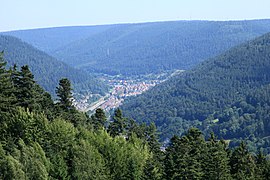
Black Forest
|
|
| River system | Rhine | |
| Drain over | Neckar → Rhine → North Sea | |
| source | Source of the Poppelbach, district Besenfeld 48 ° 36 ′ 33 ″ N , 8 ° 27 ′ 1 ″ E |
|
| Source height | approx. 822 m above sea level NN | |
| muzzle | near Besigheim in the Neckar Coordinates: 49 ° 0 '20 " N , 9 ° 8' 51" E 49 ° 0 '20 " N , 9 ° 8' 51" E |
|
| Mouth height | approx. 170 m above sea level NN | |
| Height difference | approx. 652 m | |
| Bottom slope | approx. 6.2 ‰ | |
| length | approx. 105 km (including the Poppelbach); over the flow path of the Nagold approx. 149 km | |
| Catchment area | 2,228.4 km² at the mouth | |
| Discharge at the Pforzheim A Eo gauge : 1479 km² Location: 56.6 km above the mouth |
NNQ (01/10/1934) MNQ 1933/2009 MQ 1933/2009 Mq 1933/2009 MHQ 1933/2009 HHQ (12/21/1993) |
2.33 m³ / s 5.21 m³ / s 17.4 m³ / s 11.8 l / (s km²) 165 m³ / s 532 m³ / s |
| Discharge at the Besigheim A Eo gauge : 2228 km² Location: 350 m above the mouth |
NNQ (1996) MNQ MQ Mq |
4.77 m³ / s 7.54 m³ / s 23.03 m³ / s 10.3 l / (s km²) |
| Left tributaries | Eyach , Schmiebach , Metter | |
| Right tributaries | Kleine Enz , Nagold , Strudelbach , Glems , Leudelsbach | |
| Big cities | Pforzheim | |
| Medium-sized cities | Mühlacker , Vaihingen , Bietigheim-Bissingen | |
| Small towns | Bad Wildbad , Neuenbürg , Besigheim | |
| Residents in the catchment area | 939000 | |
 The Enz in the nature reserve between Niefern and Mühlacker |
||
The Enz is the longest left tributary of the Neckar with the largest water flow of all. The Enzkreis in Baden-Württemberg is named after her.
geography

River system
The Enz flows through two large natural spaces ; in the upper half of its course it drains the eastern half of the northern Black Forest with its tributaries , then it flows through the south-west German Gaulandschaft , in it mostly the Neckar basin .
The Enz, including its main source creek Poppelbach, has a length of about 105 kilometers. However, its right tributary Nagold , which flows into it in Pforzheim when it exits the Black Forest, is unusually longer, namely almost twice as long as its own upper course up to there; the Nagold also carries twice as much water at the mouth. Thus, above Pforzheim, the Nagold is hydrographically the main strand of the Enz river system , which is calculated in this way then about 149 kilometers long and thus the third longest among the Neckar tributaries, after the systems of Kocher and Jagst .
Source rivers
The Enz does not have its name until the village of Calmbach , where the Große Enz and Kleine Enz merge. The Große Enz has two source rivers, about 5 km long, Poppelbach and Kaltenbach , which unite in Gompelscheuer . As with the source of the Danube in Donaueschingen , the start of the (Great) Enz by name is symbolized by the nearby Enzbrunnen and this is also marketed in a similarly misleading way. (See also: Enzklösterle # Enzquelle )
With regard to the amount of water and the size of the catchment area, the Poppelbach coming from the south is the main source river, the Kaltenbach coming from the west is slightly longer and has a higher source location. The Poppelbach rises south, only 1 km north of the Nagold spring at 822 m (district Besenfeld ); the Kaltenbach northwest, on the southern slope of the Schramberg at 907 m (district Forbach im Murgtal ).
Great Enz and upper reaches in the Black Forest
From the confluence of Poppelbach and Kaltenbach, the Große Enz initially flows through a narrow forest valley, which, after a small slope, opens into the much wider valley of the Rombach (Baden spelling) or Rohnbach (Württemberg spelling), which joins from the west. The valleys of Enz, Rombach / Rohnbach and other western tributaries of the upper reaches are characterized by glacier cirques from the last ice ages down to the valley floor . After the valley widening from Enzklösterle , the Enz valley narrows again to the confluence of the next valley shaped by glaciers, the Kegeltal at Sprollenhaus. Swiveling from the previous north-east direction to the north, the Große Enz flows through the mostly wooded red sandstone plateaus of the northern Black Forest in a steep valley. From the well-known altwürttembergischen resort Wildbad the valley is densely populated. On Calmbach, where the Kleine Enz empties, Höfe an der Enz and Neuenbürg follow . There the Enz surrounds a mountain spur with Neuenbürg Castle in a large loop. The Black Forest valley of the Enz, together with the valley of the Große Enz from Gompelscheuer, has a length of around 38 kilometers and ends with the entry into the Kraichgau near Birkenfeld above Pforzheim.
The Enztal in the Black Forest near Bad Wildbad

Große Enz in the spa gardens of Bad Wildbad
_01_ies.jpg)

Enztal in Gäu and Neckar basin
After emerging from the Black Forest, the Enz flows through the mussel limestone plates of the south-west German layered state until it flows into the Neckar Gauland . In terms of natural space , the Enztal between Birkenfeld and Enzberg is included in the Kraichgau continuing to the north , and below it to the Neckar basin that extends between Stuttgart and Heilbronn .
In Pforzheim , the only major city on the Enz, the Enz (mean discharge: 6.3 m³ / s) and Nagold (11.7 m³ / s) flow together. Between Lomersheim and Vaihingen, the now wide Enz meanders relatively strongly, the valley here has very steep impact slopes . There are two deserted loops in the valley between Bietigheim and Besigheim , Hirschberg and Brachberg are their surrounding mountains . To the northeast of Besigheim, in the municipality of Walheim , the Enz flows into the Neckar .

Overview of the tributaries
Larger tributaries from the union of Kleiner and Großer Enz in Calmbach. Tributary length from the source furthest from the mouth. Rounded to full kilometers or square kilometers.
- Große Enz , left main upper course, 27 km (with upper course Poppelbach) and 116 km².
- Kleine Enz , right upper course, 20 km and 88 km².
- Trout stream , from the right in Höfen an der Enz , 4 km and 7 km².
- Eyach , from the left between Höfen an der Enz and Neuenbürg, 18 km (with the upper course Brotenaubach ) and 53 km².
- Rotenbach , from the left in the hamlet of Rotenbach near Neuenbürg , 3 km and approx. 4 km².
- Großerelbach , from the right between Neuenbürg and Birkenfeld, 3 km and 15 km².
- Pfatschbach , from the right below Büchenbronn , just before Birkenfeld , 2 km and approx. 4 km².
- Tiefenbach , from the left in Pforzheim- Brötzingen , over 2 km and over 1 km². Inconsistent.
- Malschbach , from the left over the Mühlgraben , over 2 km and under 3 km².
- Nagold , from the right in Pforzheim, 91 km and 1,144 km².
- (Bach from the Mäuerachklinge ), from the right in the Pforzheimer district Mäuerach , 3 km and 4 km².
- Igelsbach , from the left between Pforzheim- Eutingen and Niefern, municipality of Niefern-Öschelbronn , 2 km and 13 km².
- Kirnbach , from the right in Niefern, 9 km and 25 km².
- Schlupfgraben , from the left in Mühlacker- Enzberg , 7 km and 13 km².
- Erlenbach , from the left in Mühlacker , 11 km and 31 km².
- Schmie , from the left near Vaihingen , 12 km and 47 km².
- Strudelbach , from the right at Vaihingen- Enzweihingen , 15 km and 55 km².
- Dürre Enz , from the left in Oberriexingen , up to 3 km and approx. 5 km². Inconsistent.
- Glems , from the right at Markgröningen - Unterriexingen , 47 km and 196 km².
- Leudelsbach , from the right between Unterriexingen and Bietigheim-Bissingen - Untermberg , 9 km (with the upper reaches Riedbach → Furtbach) and 23 km².
- Saubach , from the right in the Bissingen an der Enz district of Bietigheim-Bissingen, 3 km and 9 km².
- Wohbach , from the right at the boundary between Bissingen and the rest of the city of Bietigheim-Bissingen, approx. 4 km and approx. 4 km². Today mostly verdolt on the lower reaches, unstable on the upper reaches.
- Metter , from the left in Bietigheim, 28 km and 133 km².
- Steinbach , from the left in Besigheim , 10 km and 12 km².
Political geography

The Enz flows through the districts of Calw , Enzkreis, Pforzheim (city district) and Ludwigsburg . Some of the upper reaches of the side streams of the Große Enz and the upper reaches of the Kaltenbach are located in the Rastatt district .
Up to the great territorial upheavals around 1803 and 1806 , the course of the Enz was predominantly in old Württemberg territory, while smaller sections were in old Baden or in knighthood territory. Wildbad, Neuenbürg, Vaihingen, Bietigheim and Besigheim are administrative towns in old Württemberg. The current areas of the Rastatt district and the Enz around Pforzheim (districts Brötzingen, Pforzheim, Eutingen, Niefern) belonged to Baden. In Oberriexingen the rule was divided between the Imperial Knights and Württemberg.
Environment and economy
Flora and fauna
The lower section of the Enz, with its river bank structures typical of the floodplain, is an ideal habitat for many plant and animal species that are typical of rivers . Many of the oxbow lakes and alluvial forests are protected as biotopes, the Enz itself as well as sections of the valley such as the nature reserve near Vaihingen-Roßwag and the Leudelsbach estuary near Unterriexingen are part of the Europe-wide Natura 2000 protected area system .
Up to 10,000 larvae of mayflies and caddis flies , dragonflies , beetles, snails and mussels have been counted in the shallow water zones . Also Strömer , Barbe , nose and bullhead have their spawning grounds here.
From early summer, the Enz is heavily weed in places with flooding buttercups and thousand leaves .
Some rare and threatened species live all year round on the Enz, which is also an important passage station for many migratory birds. These include a. Kingfisher , sandpiper , goosander , gray wagtail , pond rail and dipper . Other guests and residents of the pollarded willows and woodland are white wagtail , yellow mockers , graycatchers , nightingales and orioles .
economy


In the Black Forest, rafting was important until the beginning of the 20th century . Just like the neighboring rivers Murg and Nagold, the Enz was used to transport tree trunks, but especially logs. At this hour Schwallungen (remember storage ponds , which for Holztrift were drained) as the Poppel- and Kaltenbachsee at Gompelscheuer. In the Black Forest Enz Valley, timber and tourism dominate the economy today .
Agriculture has a certain importance in the shell limestone area of the river . In steep terraced vineyards of Enztal suspension is viticulture operated.
Industry and services are concentrated in Pforzheim (jewelry, precious metals, watches, trade, administration), but can also be found in smaller towns in the Stuttgart catchment area (especially Bietigheim-Bissingen).
Since the 5th century BC Chr. ( Early La Tène ) is operated to mining iron ore in Enztal, the visitor mine pit Frischglück shows an example of the individual stations.
water sports
The upper reaches of the Enz are mainly used by white water canoes. The most famous section is the demanding Kurpark route in Bad Wildbad. Water sports are restricted in some sections of the lower reaches to protect the ecosystem:
- Enzkreis: traffic lights at the Mühlhausen weir : do not drive on the Mühlhausen loop when the light is red
- District of Ludwigsburg: Entering the banks and landing only at the marked entry and exit points. No stepping on the gravel islands and gravel banks, no storage, barbecuing or making a fire in the bank area, except at marked and set up places
May 1 to September 30: Closure from Roßwag (river km 34.12) to Vaihingen Seemühle (km 29.94 )
Same time period, but to Sägmühle Bietigheim-Bissingen (km 13.16): if the level is below 65 cm (Vaihingen level), only a trained guide is allowed to enter, if the level is below 45 cm, it is prohibited
See also
literature
- Max Scheifele : When the forests went on a journey. Rafting in the Enz-Nagold area . G. Braun Verlag, Karlsruhe 1996, ISBN 3-7650-8164-7 .
References and comments
- ^ Friedrich Huttenlocher , Hansjörg Dongus : Geographical land survey: The natural spatial units on sheet 170 Stuttgart. Federal Institute for Regional Studies, Bad Godesberg 1949, revised 1967. → Online map (PDF; 4.0 MB)
- ↑ Josef Schmithüsen : Geographical land survey: The natural space units on sheet 161 Karlsruhe. Federal Institute for Regional Studies, Bad Godesberg 1952. → Online map (PDF; 5.1 MB)
- ↑ a b c Topographic map 1: 25,000
- ↑ Sub-processing area 45 Enz below Nagold to Neckar mouth
- ^ German Hydrological Yearbook Rhine Region, Part I 2009 State Institute for Environment, Measurements and Nature Conservation Baden-Württemberg, p. 121, accessed on January 22, 2016 (PDF, German, 1.85 MB).
- ↑ Baden-Württemberg flood center
- ↑ Karlsruhe Regional Council: TBG 45, Tab. A 7.2.1, Karlsruhe 2009
- ^ Topographic map of Baden-Württemberg, 1: 50,000.
- ↑ Friedrich Huttenlocher & Hansjörg Dongus, The natural space units on sheet 170 'Stuttgart', Bad Godesberg 1967 (series “Natural space structure of Germany”).
- ↑ Increases to the respective lowest level values calculated for the remaining catchment areas below by multiplication with the runoff donation of the catchment area between the levels Unterreichenbach (Nagold), Rotenbach (Eyach), Höfen (Enz), Pforzheim (Würm) and Pforzheim (Enz). The level values are here ( Memento of the original from January 12, 2014 in the Internet Archive ) Info: The archive link was automatically inserted and not yet checked. Please check the original and archive link according to the instructions and then remove this notice. (PDF; 1.1 MB) and available here . Differences are averaged.
- ^ Historical Atlas of Baden-Württemberg, Map VI / 13.
- ^ Ordinance of the Ludwigsburg district office regulating public use on the Enz in the Ludwigsburg district, dated April 25, 2006
Web links
- Flood forecast center with level data and a. to Enz
- Enztal cycle path
- Sub-processing area 45 Enz below Nagold to Neckar mouth
- Driving information on kajaktour.de