
Walheim
| coat of arms | Germany map | |
|---|---|---|

|
Coordinates: 49 ° 1 ' N , 9 ° 9' E |
|
| Basic data | ||
| State : | Baden-Württemberg | |
| Administrative region : | Stuttgart | |
| County : | Ludwigsburg | |
| Height : | 183 m above sea level NHN | |
| Area : | 6.14 km 2 | |
| Residents: | 3264 (December 31, 2018) | |
| Population density : | 532 inhabitants per km 2 | |
| Postal code : | 74399 | |
| Area code : | 07143 | |
| License plate : | LB, VAI | |
| Community key : | 08 1 18 074 | |
| LOCODE : | DE WLE | |
| Address of the municipal administration: |
Hauptstrasse 68 74399 Walheim |
|
| Website : | ||
| Mayoress : | Tatjana Scheerle | |
| Location of the municipality of Walheim in the Ludwigsburg district | ||
  |
||

Walheim is a municipality in the Ludwigsburg district in Baden-Württemberg with important viticulture . It belongs to the Stuttgart region (until 1992 the Middle Neckar region ) and the European metropolitan region of Stuttgart . Apart from the village of Walheim, no other places belong to the municipality of Walheim.
geography

Geographical location
The municipality of Walheim extends from the west bank of the Neckar River in the east to the left edge of the river heights in an amount ranging from about 170- 278 m above sea level. NN . On the southern edge, its largest tributary, the Enz, flows into the Neckar, through the municipality just below the significantly smaller Baumbach, which also comes from the west .
On the bank and on the flatter lower slope up to almost 250 m above sea level. NN lies the village of Walheim on both sides of the Baumbach, above which there are vineyards in the higher parts of the slope. The Aussiedlerhof group Wannengrabenhöfe has recently emerged on the plateau near the western boundary of the municipality.
Community structure
The village of Walheim is the only part of the municipality. In the area of the municipality there used to be the now defunct Dambach village .
Neighboring communities
Walheim is bordered in turn by the municipality of Kirchheim am Neckar in the north, the municipality of Gemmrigheim in the east, the town of Besigheim in the south, the municipality of Löchgau in the southwest and the town of Bönnigheim in the west , all of which also belong to the Ludwigsburg district.
climate
The annual mean temperature is 9.5 ° C and rainfall of 700 l / m². Due to the mild climate, there are naturally no conifers in the only approx. 90 hectare Walheimer Wald Hart south of the Baumbach, only mixed deciduous forests with a high proportion of oak.
Division of space

According to data from the State Statistical Office , as of 2014.
history
Already in the Younger Stone Age around 4000 to 2500 BC. The area around Walheim was inhabited. A female skeleton found in 1980 is dated to around 1500 BC. And thus belongs to the Bronze Age . From 450 BC Chr. Were Celtic defense and residential complexes erected.
Numerous traces of Roman times have been preserved in Walheim: the remains of two Roman forts from around 85 to 120 AD and an extensive civilian settlement are on the markings . An important trading center was located in the area where the town is today.
From 233 AD the middle Neckar valley was settled by the Alemanni . In 496 AD the area became Frankish .
Walheim was first mentioned in a document in 1071 AD. At this point in time, various monasteries owned the Walheimer Grund. In the 13th century Walheim was owned by the Margraves of Baden, in 1463 it became Palatinate and in 1504 it passed into the hands of Duke Ulrich von Württemberg . From 1520 Austria was in charge.
The Walheimers took part in the Peasant Wars under Jörg Ratgeb and Matern Feuerbacher in the spring of 1525. Four years later, the Margrave of Baden managed to buy the place back into his possession. From 1596, Walheim was the Württemberg municipality.
A large part of the population and the buildings fell victim to the Thirty Years' War . The biggest losses were probably in 1634, when the Swedes burned down a large part of the village after the Battle of Nördlingen . With 172 fatalities, Walheim lost a quarter of the population. Walheim also suffered from the effects of various wars in the 17th and 18th centuries.
Although the social conditions in the 19th century during the times of the Kingdom of Württemberg became more bearable with the liberation of the farmers , Walheim was plagued by epidemics, bad harvests and floods. The most devastating flood occurred on October 30, 1824. Many Walheimers left their homeland and sought their fortune by emigrating to the USA or the Balkans . Only towards the end of the 19th century did the living conditions improve in the course of industrialization .
Walheim belonged to the Oberamt Besigheim , with which it opened in 1938 in the Ludwigsburg district. The period of reconstruction after the Second World War created prosperity in the place. From 1980 to 1988 archaeological investigations took place, which gave information in particular about the Roman history of Walheim. The Roman House Museum also dates from this period.
In 1996 the Walheimer Verein Die Türmer entered the Guinness Book of Records by building the tallest free-standing lath tower in the world at 25.19 m.
Religions
Walheim has been evangelical since the Reformation was introduced in the 16th century . Supporters of the Catholic and the Evangelical Methodist Church are still spiritually cared for by the respective parishes in Besigheim .
All three denominations each have their own church buildings in the old town center, and there is also a Protestant parish hall.

Protestant church

Methodist Church


politics

mayor
- 1994-2005: Martin Gerlach
- 2005–2018: Albrecht Dautel
- since 2018: Tatjana Scheerle
Municipal council
The municipal council in Walheim has 12 members. The municipal council consists of the elected voluntary councilors and the mayor as chairwoman. The mayor is entitled to vote in the municipal council. The local elections on May 26, 2019 led to the following final result.
| Parties and constituencies |
% 2019 |
Seats 2019 |
% 2014 |
Seats 2014 |
||
| FW | Free electoral association | 54.0 | 6th | 74.6 | 9 | |
| OIL | Open list | 38.3 | 5 | 25.4 | 3 | |
| GfW | Together for Walheim | 7.7 | 1 | - | - | |
| total | 100.0 | 12 | 100.0 | 12 | ||
| voter turnout | 63.0% | 53.2% | ||||
badges and flags
The Walheim municipal coat of arms shows the golden capital letter W in gold on a red oblique left bar. The municipality flag is yellow-red. The coat of arms and flag were awarded on February 19, 1958.
Partnerships
Walheim since 1999 with the four municipalities Anetz , Pouillé-les-Côteaux , La Roche-Blanche and Saint-Herblondes the former administration federation "of Grées" in France ( Region Pays de la Loire , the Loire-Atlantique ) and with the Croatian community Friends of Barban .
Attractions
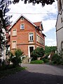
Walheim is on the Württemberger Weinstrasse , which leads past many sights. The town center is protected as a historical monument , which can be achieved when using the existing buildings. T. poses problems. The old school building in need of renovation, for example, was originally intended (as of July 2007) to be converted into a health center, but this would have resulted in parking problems. Ultimately, the decision was made to convert the building into a residential building, the first tenants of which moved in in spring 2013 after extensive renovation work.

Old school house from 1875
Schoolhouse from 1900


Roman House Museum
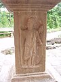
During development work for a new building area in the 1980s, a civil Roman settlement with around 30 buildings from the 2nd century AD was discovered and excavated on four hectares. In the center of this settlement, the ruins of an approximately 550 m² building in extraordinarily good preservation, which is interpreted as a trading house, were uncovered. It contained business and storage rooms, stables and living quarters of the dealer. In order to be able to preserve this important find on site, the new building area was redesigned and a shelter was built over the site. This is now accessible to visitors as the Roman House Museum. The museum is part of the Archaeological State Museum Baden-Württemberg .

Roman house with replica of the giant Jupiter column from Walheim

Jupiter giant column

Roman doorstep in front of the museum

View into the Roman house

Four gods stone of the Jupiter giant column, Hercules relief
Four god stone of the Jupiter giant column, Minerva relief

Four god stone of the Jupiter giant column, Juno relief

Column base (?)


Economy and Infrastructure

Walheim is a wine-growing place whose vineyards belong to the large Schalkstein site in the Württemberg lowlands of the Württemberg wine-growing region . In the vicinity of the village is the Walheim power plant , which was in operation until July 5, 2016 and has since been in cold reserve. The power plant should finally go offline at the end of March 2018.
traffic
In Walheim there is a train station on the Frankenbahn Stuttgart - Würzburg . There are connections with regional trains to Stuttgart, Heilbronn , Neckarsulm and Osterburken every 30 minutes (on weekends 30/60) . Individual Regional Express trains on the Stuttgart - Würzburg route also stop in Walheim early in the morning and late in the evening . Walheim is connected to the VVS .

The federal road 27 bypasses Walheim by means of a bypass ; the next motorway junction is the Mundelsheim junction on the A 81 .
Educational institutions
Walheim has only had one elementary school since 1971; secondary schools are located in Besigheim. The elementary school Walheim is affiliated with a primary school support class. She owns a school garden that has already received several awards. In cooperation with the municipality and the forestry office, a small arboretum has been built on the edge of the municipal forest since 2003 . Every first class plant a tree soon after starting school. The number of students is around 170.
In Walheim there are also two kindergartens that offer different care models.
Supply and disposal
The electricity and natural gas network in the municipality is operated by Netze BW GmbH (a company of EnBW Energie Baden-Württemberg AG). The municipality of Walheim obtains its drinking water exclusively from the Lake Constance water supply . The waste is taken from the Abfallverwertungsgesellschaft the district Ludwigsburg mbH (AVL), a 100% subsidiary of the district Ludwigsburg. AVL is commissioned to carry out the tasks of avoiding, recycling and disposing of waste on behalf of the Ludwigsburg district.
Personalities
Sons and daughters of the church
- Johannes Christoph Harpprecht (1560–1639), Professor of Law at the Eberhard Karls University of Tübingen
- Roland Bothner (* 1953), art historian, philosopher, writer, artist, wrote about his childhood and youth in Walheim in: Schwäbische Jugend. Also a way to philosophy.
People who work or have worked in Walheim
- Philipp Ludwig Hermann Röder (1755–1831), pastor in Walheim from 1811
Web links
Individual evidence
- ↑ State Statistical Office Baden-Württemberg - Population by nationality and gender on December 31, 2018 (CSV file) ( help on this ).
- ↑ State Statistical Office, area since 1988 according to actual use for Walheim.
- ↑ http://www.walheim.de/website/de/gemeinde/historie History of Walheim

Affalterbach | Asperg | Benningen am Neckar | Besigheim | Bietigheim-Bissingen | Bönnigheim | Ditzingen | Eberdingen | Erdmannhausen | Erligheim | Freiberg am Neckar | Freudental | Gemmrigheim | Gerlingen | Grossbottwar | Hemmingen | Hessigheim | Ingersheim | Kirchheim am Neckar | Korntal-Münchingen | Kornwestheim | Löchgau | Ludwigsburg | Marbach am Neckar | Markgröningen | Möglingen | Mundelsheim | Murr | Oberriexingen | Oberstenfeld | Pleidelsheim | Remseck am Neckar | Sachsenheim | Schwieberdingen | Sersheim | Steinheim an der Murr | Tamm | Vaihingen an der Enz | Walheim