
Schwieberdingen
| coat of arms | Germany map | |
|---|---|---|

|
Coordinates: 48 ° 53 ' N , 9 ° 5' E |
|
| Basic data | ||
| State : | Baden-Württemberg | |
| Administrative region : | Stuttgart | |
| County : | Ludwigsburg | |
| Height : | 274 m above sea level NHN | |
| Area : | 14.87 km 2 | |
| Residents: | 11,383 (Dec 31, 2018) | |
| Population density : | 766 inhabitants per km 2 | |
| Postcodes : | 71701, 71706 | |
| Area code : | 07150 | |
| License plate : | LB, VAI | |
| Community key : | 08 1 18 067 | |
| LOCODE : | DE SWI | |
| Address of the municipal administration: |
Schlosshof 1 71701 Schwieberdingen |
|
| Website : | ||
| Mayor : | Nico Lauxmann ( CDU ) | |
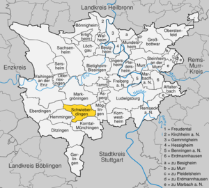
| Location of the community Schwieberdingen in the district of Ludwigsburg | ||
  |
||

Schwieberdingen is a municipality with around 11,000 inhabitants in the Ludwigsburg district . It is located around five kilometers from the district town of Ludwigsburg and ten kilometers from the Baden-Württemberg state capital Stuttgart . It belongs to the Stuttgart region (until 1992 the Middle Neckar region ) and the European metropolitan region of Stuttgart .
The place, possibly founded in the 3rd century, was first mentioned in a document in 1304. It was shaped above all by its location on the old trade and military route leading from Flanders to the Black Sea, on which today's B 10 runs.
After the Second World War, the community changed fundamentally. A modern industrial community emerged from the predominantly agricultural village through the settlement of large companies.
geography
Geographical location

Schwieberdingen is located in the southwestern Neckar basin , a loess-covered plateau in the center of Baden-Württemberg , cut by river valleys , and is located a little south of the 49th parallel.
The landscape around Schwieberdingen shows a great variety of soil forms, which can also be recognized by the field names with the endings -berg, -grund or -tal. The small river Glems flows through the village and has dug its way into the limestone of the otherwise slightly undulating terrain of the Lange Feld and the Strohgäus . In the Glemstal itself there are larger contiguous floodplains that are periodically flooded.
Around 35% of Schwieberdinger's land area consists of settlement and traffic areas, around 62% of agricultural land. The rest consists of forest and water areas.
The highest point in the district, the Katharinenlinde, is 351 m above sea level. NN, the lowest at the boundary in the lower Glemstal at 238 m above sea level. NN.
Neighboring communities
Five cities and municipalities border the municipality of Schwieberdingen. Starting clockwise in the north, these are Markgröningen , Möglingen , Korntal-Münchingen , Hemmingen and Eberdingen .
climate
Schwieberdingen is characterized by its mild climate, which is characterized by its location in the southwestern Neckar basin - shielded by the Black Forest in the west, the Swabian Alb in the south, the Swabian-Franconian Forest in the east and the Strom and Heuchelberg area in the northwest. In addition to the Upper Rhine Valley, the greater Stuttgart area - which Schwieberdingen belongs to - is one of the warmest areas in Germany. The warmest month is July with an average monthly temperature of 18.8 ° C, while January, the coldest month, has an average of 1.3 ° C. In addition to the mild temperatures, the long duration of sunshine, low precipitation and low wind speeds with a high frequency of calm are characteristic. The mean annual rainfall in Schwieberdingen is 679 mm. As usual in southern Germany, the main precipitation falls in summer, with June and August having the highest amounts of precipitation. The lack of precipitation in the region meant that an external water supply was necessary at an early stage, whereupon the Lake Constance water supply was built up from 1954.
Division of space

According to data from the State Statistical Office , as of 2014.
history
prehistory
The first verifiable traces of settlement in what is now the Schwieberdingen district have been around since the Neolithic . The extremely fertile soil and the ford across the Glems moved in as early as 5000 BC. First settlers. There are two settlements found by the Baden-Württemberg State Monuments Office . The older group - referred to in specialist circles as the Schwieberdinger group - dates from around 4300 to 4200 BC. Classify. The skeleton of a young woman called Mathilde , who was discovered in a stool grave, belongs to her . Lived. The second settlement dates back to the Michelsberg culture and is around 700 to 800 years younger than the Schwieberdinger group .
From 85 AD onwards, the Romans conquered the country from the Celts and left their traces, among other things, due to the construction of the Roman road leading through the later town and over the ford on the Glems . The old Roman road, which later shaped Schwieberdingen for centuries, was the most important road in the country and a main connection between the Rhine and the Danube at that time. It was mainly used for military purposes. For example, the Roman emperor Hadrian and his legions crossed the area between the years 117 and 138. In addition to the Roman road, the remains of Roman manors - which are reminiscent of the intensive agricultural use - and other archaeological finds show further traces of Roman settlement in the first centuries AD.
Alemannic and Frankish times
In the 3rd century, the Alamanni conquered the Roman territory as far as the Rhine. During this time, the present-day place was possibly founded around 260 AD under the name Suidbert-ingen , which can be traced back to the Alemannic clan leader Suidbert. After the victory of the Franks over the Alamanni around 500, the area that would later become the Schwieberdingen mark was on the tribal border between the Alamanni in the southeast and the Franks in the northwest. After Christianization, this border also became the diocese border between the Franconian diocese of Speyer and the Alemannic diocese of Constance. The location of Schwieberdingen at the intersection of the tribal border and the trunk road as well as the importance of the ford for this traffic route, which is so important from Flanders to the Black Sea and Italy, suggest that the village was founded for military reasons - to protect the ford.
Various archaeological finds on today's Schwieberdingen markings show that there were once several Alamannic settlements. Between 750 and 802 the village of Vöhingen, located in the eastern part of the district and abandoned in the 14th century, was first mentioned in a document. The desert has now been thoroughly archaeologically examined in 2005.
First written mention
The previously known first written mention of Schwieberdingen was in the Esslinger Urbar from 1304, in which two acres of arable land versus Swiebertingen are described. In the 14th century, the Counts of Württemberg began to expand their rule in the region. On October 18, 1321, Count Bürgin the Younger of Hohenberg-Nagold also sold the church set in Schwieberdingen to Count Eberhard the illustrious of Württemberg. In addition to the Counts of Württemberg, the Lords of Nippenburg , whose seat of the same name is a little south of the village and was first mentioned in documents in 1160, owned the village.
Troubled times from the 16th to the 19th century

In the 16th and 17th centuries, Schwieberdingen suffered badly from wars and diseases. The plague came over the place three times . In August 1584 alone, 88 people died of the disease. Soon afterwards, the severely decimated population was hit by new horrors. Just as peacetime had a favorable effect on the place that expanded along what would later be the Imperial, Trade and Army Roads through the passage of traders and merchants, so the armies that passed through in wartime also brought hardship and misery. The Thirty Years War thinned the population again. Schwieberdingen was of looting and arson ravaged. During this time there was not a single entry in the church register for nine years. According to an inscription in the sacristy, the place is said to have been completely deserted. Repeated incursions by French troops between 1688 and 1707 caused further devastation and economic damage. In 1707, when the French managed to cross the Rhine again under their leader, Marshal Villars , the French troops took up quarters in Schwieberdingen on June 4, 1707. After two days of negotiations, the Württemberg government bought the protection of the country for one million guilders, which was documented in the Schwieberdingen contract concluded there.
Shortly before the end of the 18th century, troops passed through the town again. The grave of the fallen Austrian officer Heinrich von Parzer in the cemetery testifies to the fighting between Austrian and French troops. Presumably the Austrian rear guard was supposed to secure the road and the Glemsübergang.
Not only wars took a heavy toll on the inhabitants of the municipality belonging to the Markgröningen district office. The rural population also became increasingly impoverished due to frequent bad harvests and the right to share inheritance . Famine and unemployment drove many residents to emigrate to Poland, Hungary and America in the 19th century.
When the new administrative structure was implemented in the Kingdom of Württemberg , which was founded in 1806 , Schwieberdingen was assigned to the Oberamt Ludwigsburg in 1807 .
From the German Empire to the Second World War
From the second half of the 19th century there were significant advances in technology in the place. The aqueduct was built in 1878. A post and telegraph station was also built. Around 1900 the main street through the village was paved and soon the first automobiles were driving along. In 1906 Schwieberdingen received a direct railway connection with the construction of the Strohgäubahn . In the same year the place was provided with electric light, whereby the previously used kerosene lamps had become obsolete.
In the First World War from 1914 to 1918 around 50 Schwieberdinger fell. The post-war period with inflation until 1923 as well as the Great Depression of 1929 and the rapid rise in unemployment affected the residents in the following years.
After the National Socialists came to power in 1933 and the Enabling Act was passed, the municipal council was brought into line. The mayor Eugen Herrmann remained in office. Organizations of the labor movement such as the Schwieberdingen workers' sports club were banned.
During the administrative reform in Württemberg during the Nazi era , Schwieberdingen became part of the new Ludwigsburg district in 1938 .
Due to the events of the Second World War from 1939 to 1945, a considerable number of Schwieberdingen citizens lost their lives. 71 residents fell, 20 were missing. Despite numerous air raids towards the end of the war, which were primarily aimed at the radio system stationed at the sports field, the site itself suffered only minor damage to the building. Only the Glemsbrücke, built in 1928, was blown up by the retreating Wehrmacht in the last days of the Second World War . On April 21, 1945, the 1st French Army marched in from the west, occupied the place and advanced towards Ludwigsburg and Stuttgart. A short time later, the Second World War ended after the surrender of the German Reich.
Younger story
Since the place had become part of the American occupation zone after the Second World War , it had belonged to the newly founded state of Württemberg-Baden since 1945 , which was incorporated into the current state of Baden-Württemberg in 1952.
After the end of the war, a large number of displaced persons and refugees moved to Schwieberdingen. The place changed significantly. The formerly rural village became a modern, commercially oriented community. Due to the economic upturn, more and more companies settled in Schwieberdingen. The largest and financially most important company has been Robert Bosch GmbH since 1963 . The population grew by leaps and bounds, so that the residential areas are slowly approaching the boundaries of the district. In 2004 the 10,000-inhabitant limit was exceeded. Today the community has around 11,000 inhabitants.

religion
The community Schwieberdingen was originally located on the border between the dioceses of Constance and Speyer formed by the Glems river . The place itself belonged to the diocese of Speyer. As in all of Württemberg, the Reformation was introduced in Schwieberdingen from 1534 . As a result, the place was predominantly Protestant for many centuries and the Schwieberdinger Georgskirche , built in the 14th century, became the evangelical church of the place.
After the Second World War , the first Catholics came to Schwieberdingen through the many expellees from the eastern regions . While only two percent of the population were Catholic in 1945, the number of Catholic parishioners increased to 369 by 1950, which corresponded to about 17 percent of the population. They initially accepted the offer of the Protestant community to celebrate their services in the Georgskirche, before the Catholic Church of St. Peter and Paul was consecrated on April 4, 1964.
In addition to the two large churches, there is also the New Apostolic Church in Schwieberdingen .
Districts
The Hardthof , located in the northwest of the Schwieberdinger district, forms a hamlet together with the Schönbühlhof . The founding of what was then Hart Hof by two families from Schwieberdingen in 1760 has been handed down as carved in stone. The neighboring Schönbühlhof, which was founded in 1770 by three families from Markgröningen, is a little younger.

A special feature is the joint management of the Hardthof and Schönbühlhof , as the boundary between Schwieberdingen and Markgröningen runs through the middle of the town with around 300 residents, sometimes even through a few houses .
Every eight years, all residents of the village of legal age elect a “lawyer” from among their number to represent and advocate. This lawyer, who was elected for life until 1991, represents the interests of the hamlet towards its two mother communities. In the "protocol book", which has existed since 1797, the lawyers in office write down the resolutions, agreements and problems of the place. In the previous municipal code, lawyers also had municipal law status. They were elected, had to hold meetings and were represented on the local council. There are no longer any lawyers officially in the current municipal code. On the Hardt- and Schönbühlhof, however, the function was retained outside of the legal basis.
Population development


The population figures described are based either on estimates, census results or official updates from the respective statistical offices (main residences only).
|
|
|
politics
Municipal council
The municipal council in Schwieberdingen has 18 members. The local elections on May 26, 2019 led to the following result. The municipal council consists of the elected voluntary councilors and the mayor as chairman. The mayor is entitled to vote in the municipal council.
| Parties and constituencies |
% 2019 |
Seats 2019 |
% 2014 |
Seats 2014 |
||
| FWV | Free voter association Schwieberdingen e. V. | 26.44 | 5 | 28.60 | 5 | |
| CDU | Christian Democratic Union of Germany | 18.97 | 3 | 20.98 | 4th | |
| GREEN | Alliance 90 / The Greens | 16.34 | 3 | 8.95 | 2 | |
| ABG | Active community of Schwieberdingen | 14.69 | 3 | 15.28 | 3 | |
| FDP | Free Democratic Party | 12.88 | 2 | 12.78 | 2 | |
| SPD | Social Democratic Party of Germany | 10.67 | 2 | 13.42 | 2 | |
| total | 100.0 | 18th | 100.0 | 18th | ||
| voter turnout | 61.46% | 52.23% | ||||
Mayor since 1875
- 1875–1892: Konrad Völlm ( mayor )
- 1893–1915: Karl Zoller ( Mayor )
- 1915–1919: Karl Schober (acting mayor)
- 1919–1941: Eugen Herrmann (Mayor)
- 1941–1945: Otto Surber (acting mayor)
- 1945–1948: Friedrich Rothacker (acting mayor)
- 1948–1981: Hermann Butzer (Mayor)
- 1981-2013: Gerd Spiegel, independent (mayor)
- since 2013: Nico Lauxmann, CDU (Mayor)
badges and flags
Blazon : "In blue, an eight-pointed gold star, surmounted by two ringless, facing gold wolf anchors ."
In the Oberamtsbeschreibung from 1859 it is described: "The local coat of arms consists of two crescent moons standing apart, between which there is a star."
This interpretation has been adopted for almost a century. Based on historical documents, it is now known that these are not crescent moons, but the crescent-shaped anchors of wolf fishing rods, which were hung in the branches with the actual double hooks attached. Wolf anchors such as double hooks, the wolf tang, used to be part of a hunter's equipment as fishing gear and, like other hunting and fishing utensils, were used as coat of arms symbols in the Middle Ages.
On December 4, 1980, the municipality was awarded a yellow-blue flag by the Ludwigsburg district office. However, the flag actually used by the municipality deviates from the color sequence and is blue-yellow.
Partnerships
The oldest Schwieberdingen partnership exists with the French city of Vaux-le-Pénil , which has around 10,800 inhabitants and is around 40 km south-east of Paris. In addition to size, there are other similarities between the two places: Vaux-le-Pénil also took on new forms after the Second World War due to enormous industrial growth and many residents commute daily from Vaux-le-Pénil to Paris, 40 km away. The foundation stone for the town twinning was laid in the 1980s through contacts in the field of school, sport and also singing. The first visit of the Schwieberdingen municipal council to Vaux-le-Pénil took place in June 1990. In addition to the official contacts, partnerships at club level and numerous personal friendships have also emerged in recent years. In addition to the municipal administration, the contacts to France and the USA are looked after and coordinated by the Schwieberdingen city partnership .
Schwieberdingen also maintains friendly relationships across the Atlantic. From the first association contacts, which were made in 1987, a partnership developed between Schwieberdingen and Belvidere in Illinois in the USA .
After reunification, the first contacts to Großharthau in Saxony were made in 1991 . In addition to the communal partnership, the two volunteer fire brigades in particular maintain an intense friendship. The first marriage between a citizen from Schwieberdingen and a citizen from Großharthau was concluded in 2005.
Culture and sights
Museums

The local museum has been housed in the old rectory from the 16th century near the Georgskirche since March 1991 . After extensive renovation measures, the local history museum shows its holdings on rural and bourgeois everyday culture from 1870 to 1920 on three floors. The permanent furnishings include furniture, textiles and handicrafts of all kinds as well as a variety of kitchen utensils, glass and porcelain. There are also other exhibits on the subject of playing and learning .
On the top floor, a model of the location shows the small and manageable village at the beginning of the 19th century. Three important trades that used to be common in the area - carpenter , tailor and shoemaker - are shown in the Chamber of Crafts. They are complemented by a fully equipped forge in the museum courtyard.
The deep cellar carved out of the rock reminds of Schwieberdingen's past as a wine-growing community and the traditional lamb brewery.
.jpg)
music
As the oldest Schwieberdingen association, the Liederkranz was founded in 1840 , which in 1848 gave itself the name, still valid today, of the singing association of Schwieberdingen .
The Schwieberdingen music association , in which around 110 active musicians now play in three different bands , was founded in 1925. In the 1970s, the music association founded its own music school, which was transferred to today's Schwieberdingen music school in 1989 .
The Strohgäu Symphony Orchestra , based in Schwieberdingen , has existed since 1950. The orchestra consists of a permanent community of amateur musicians and is directed by Frédéric Tschumi. The orchestra traditionally plays two serenade concerts in spring and three symphony concerts in autumn. However, there are also various special concerts at home and abroad. The Strohgäu Symphony Orchestra has given concerts in Caen (France), Pamplona (Spain) and Coventry (England).
The Schwieberdingen music school was founded in 1989 by the community of Schwieberdingen and the clubs and associations that make music. At the beginning, the students of the Schwieberdingen music club, the Strohgäu-Sinfonieorchester Schwieberdingen, the evangelical trombone choir and existing private classes of early musical education and recorder training were taken over. With these approximately 180 students, classes began in October 1989. After a brief provisional management by the headmaster of the neighboring community, the music teacher Berthold Huss was appointed music school director. Since then he has been running this successful institution, which as a communal institution has become an indispensable part of public life. The music school has a wide range for children from 20 months and is also open to adults. It actively trains the next generation for the music-making clubs and associations and is constantly expanding its range to meet the increasing demand for contemporary musical and cultural leisure activities. The motto of the Schwieberdingen Music School is: "Music is (y) our first love!" The four goals can be summarized as: "Hobby - Leisure - Education - Care".
Buildings

The Nippenburg castle ruins are just outside in the south . The castle , built on a mountain spur surrounded by the Glems , was built by the Lords of Nippenburg and was first mentioned in a document in 1160. The castle complex, with all its foundation walls, is the only castle ruins from this period in the greater Stuttgart area .
The Georgskirche is located on the edge of the town center . The very well-preserved fortified church from the 14th century, surrounded by a mighty curtain wall , was given its current appearance in the years 1495 to 1498, when Ludwig von Nippenburg had the church expanded in the late Gothic style by the ducal builder Peter von Koblenz . The 43 m high church tower was initially built around 1515 with a pointed tower roof. The upper part of the tower was destroyed by a severe lightning strike in 1795. During the reconstruction, the church received its current spire.

The Schwieberdinger Schlössle opposite the Georgskirche is an old Nippenburg-Wallbrunnsch manor. In 1773 the ducal Württemberg Chamber of Commerce took over the building that King Friedrich I lived in as prince and at times during his reign. Today the Schlössle is owned by the municipality.
The moated castle is in the center of the village . After several renovations, the conversion of former houses into barns and stables and the filling of the moat , the building no longer has the appearance of a moated castle. Today the Schwieberdingen town hall is housed in the former moated castle.
At the edge of the built-up area, the B 10 crosses the Glems on a monumental viaduct. The Glemstalbrücke , built in 1962, spans the valley at a height of 38 meters and a length of 280 meters. The historic stump mill is located on the Glems .
In 1998 the community center Schwieberdingen was completed in the town center. This modern building houses the local library, the citizens' hall, club offices, the music school with secretariat and classrooms as well as rehearsal rooms for the local orchestras. It quickly developed into a cultural meeting place with a visitor frequency of around 55,000 people per year. The former Bruckmühle from the 15th century serves as a meeting place for citizens .
In 2004 the newly built Felsenberg Arena was inaugurated, in which the footballers of TSV Schwieberdingen have played their home games ever since.
Natural monuments

In addition to the nature reserves in the Glemstal, Münchinger Tal and around the Nippenburg, there are numerous natural monuments in the area . These include, for example, the Katharinenlinde , the Markt wetland or the poplar group at the Vöhinger Kirchle .
Sports
Schwieberdingen is home to nearly twenty sports clubs . The largest and most traditional in the municipality is TSV Schwieberdingen, founded in 1906 . The most successful and best-known teams of the TSV is that once in the Bundesliga playing fist shooting , as well as the 2007/08 in the Oberliga Baden-Wuerttemberg playing football . Other well-known sports clubs beyond the municipal boundaries include the Schwieberdingen tennis club , the Schwieberdingen ski guild or the Kawa club .

Sports enthusiasts in the community have a total of three halls at their disposal: the gymnasium and festival hall , the sports hall at the indoor pool and the Felsenberg hall . In addition to the football stadium, the sports facilities around the Felsenberg Arena offer various training grounds and a sports field with an athletics track. There are also athletics facilities in Herrenwiesenweg, opposite the secondary school. The Schwieberdingen indoor swimming pool offers a sports pool and a learning pool.

There are various cycling and hiking trails for individual leisure activities. The Glemsmühlen cycle path crosses Schwieberdingen on its 40 km long path from Glemseck to the confluence of the Glems in the Enz near Unterriexingen, as does the 30 km long Celtic cycle path from Hohenasperg to Ditzingen, which leads past various testimonies of Celtic culture .
In 1987 the fourth stage of the Tour de France passed through Schwieberdingen. The only 71 km long stage from Stuttgart to Pforzheim on July 5, 1987 won the Belgian Herman Frison .
The Nippenburg Castle golf course is just outside . The 18-hole championship course, designed by Germany's most successful athlete Bernhard Langer , hosted the German Open three times from 1995 to 1997 .
In February 2008, the Klafs Tennis Grand Prix, a tennis world ranking tournament, took place in the Schwieberdinger tennis hall.
Regular events
- Carnival : Every year the Gagerbach witches storm the Schwieberdingen town hall on "Schmotzige Thursday" and take over government affairs until Ash Wednesday.
- Whitsun weekend: Kawa festival
- July: Traditionally on the third weekend in July, the four-day music festival of the Musikverein takes place on the festival square at the train station.
- October: Every year for Thanksgiving, a mosaic of seeds, blossoms and fruits is laid in the Georgskirche and can be visited until the Sunday of the Church.
- November: Cherry Sunday and "Kirbemeedich"
- December: Annual concert of the Musikverein
- 2nd Sunday in Advent: Christmas market
Economy and Infrastructure
.jpg)
traffic
The B 10 , which runs through Schwieberdingen and which was a main connection between the Rhine and the Danube in Roman times, no longer crosses the center of the town after the bypass road was built in 1962, but is now north of its original location. It separates the industrial and residential areas. The next motorway junction on the A 81 is Stuttgart-Zuffenhausen about 3 km southeast of Schwieberdingen.
The Strohgäubahn runs regularly between Korntal and Heimerdingen (or individual trains continue to Weissach ) via Schwieberdingen station in the south of the village. Furthermore, the high-speed line Mannheim – Stuttgart (via Vaihingen an der Enz ) runs northeast of Schwieberdingen, but without a stop. In addition, Schwieberdingen has some local and regional bus connections that are part of the Stuttgart Transport and Tariff Association. At the moment the connection to the planned Ludwigsburg tram is under discussion.
Stuttgart International Airport is located in Leinfelden-Echterdingen, about 25 km away .
Industry and economy

Due to the location of Schwieberdingen - formerly called the village on the street - on the busy imperial and trade route and the armies, merchants and traders passing through, inns and craftsmen such as blacksmiths , wagons and saddlers had an important role in earlier times. In addition, Schwieberdingen was characterized by agriculture until the 1950s.
With the establishment of the lamb brewery in 1812, the first industrial company was established in Schwieberdingen. The Schwieberdinger Lamm-Bräu produced there was known far beyond the district's borders. By the 1970s, the number of employees rose to around 60 with 16,000 bottles filled per hour. In 1981 the medium-sized brewery company was sold to the large brewery Stuttgarter Hofbräu and had to cease operations.
Since the 1960s the industry and with it the number of jobs in Schwieberdingen has developed rapidly. The companies based in the municipality - mainly from the automotive supply industry and the forwarding trade - now employ a total of 7,740 people. Of the 4053 non-self-employed workers living in the village, only 942 are employed in Schwieberdingen themselves. The unemployment rate in 2005 was around five percent.
With around 6,300 employees, Robert Bosch GmbH, with its development center in the automotive technology division, which has been located in Schwieberdingen since 1968, is by far the largest employer in the municipality. Other well-known local companies are:

- Knorr-Bremse , Systems for Commercial Vehicles GmbH
- Haulage company Große-Vehne, Stuttgart
- Erwin Steinle, Internationale Spedition GmbH & Co. KG
On April 3, 2019, the municipality announced that the Porsche company would like to acquire a 15-hectare site in Schwieberdingen that was previously used for agriculture. A referendum was held on July 14, 2019 and 57 percent approved the new industrial park.
Public facilities
There are two old people's and nursing homes of the district's own Kleeblatt nursing homes .
education
The school system in Schwieberdingen goes back to the 16th century. In 1559 the old schoolhouse was built as the second elementary school in what is now the Ludwigsburg district. Even before the First World War, the building had become too small, so a new schoolhouse was built in 1914, which now houses the primary school on the mountain. In addition to the two primary schools and the secondary school, which are jointly managed as Hermann-Butzer-Schule , there is also the Schwieberdingen-Hemmingen Realschule (RSSH) on site . The next high schools are in Markgröningen and Korntal-Münchingen . Since 1989 there has also been the Schwieberdingen Music School , a registered association sponsored by the Schwieberdingen community, which is open to all residents (including the neighboring communities of Hemmingen , Markgröningen and Möglingen ).
In the field of adult education, there is the Schwieberdingen adult education center.
Supply and disposal
The electricity and gas network in the city is operated by EnBW Regional AG. The northern part of Schwieberdingen is supplied with external water from the Lake Constance water supply. For the drinking water in the southern part, water from the Lake Constance water supply and own water from the Herrenwiesen deep well are mixed. The water for the Hardthof and Schönbühlhof is obtained from the Strohgäu water supply. The waste is taken from the Abfallverwertungsgesellschaft the district Ludwigsburg mbH (AVL), a 100 percent subsidiary of the district Ludwigsburg. AVL is commissioned to carry out the tasks of avoiding, recycling and disposing of waste on behalf of the Ludwigsburg district.
Personalities
- Due to the good traffic situation, Friedrich I , who was crowned King of Württemberg in 1806, spent seven years frequently in the Schwieberdinger Schlössle opposite the Georgskirche, as he could quickly send and receive couriers with messages here.
- According to Aberlin Jörg , who is reminded of a coat of arms on the south wall of the church, Anton Pilgram and Peter von Koblenz played a key role in the construction of the Georgskirche in Schwieberdingen .
- In 1783 Friedrich Schiller stayed for a short time at the Schwieberdinger Gasthaus Zum Löwen , where Carl Maria von Weber and the Swabian pastor Johann Friedrich Flattich also frequented.
- During his time as coach of Bundesliga club VfB Stuttgart , national soccer player Matthias Sammer lived in Schwieberdingen from 2004 to 2005.
- The for TSV Schwieberdingen launching Helga Feyrer that a German long-distance record of women in Freiberg with 63,393 meters 2006 24-hour swimming has set.
- Grazia di Fresco, who became known as the singer Sha , grew up in Schwieberdingen.
- Manfred Bulling , regional president in Stuttgart from 1977 to 1989, lived in Schwieberdingen.
literature
- Susanne Arnold: Village dying ... Vöhingen and what remained of it . Landesdenkmalamt Baden-Württemberg, Stuttgart 1998, ISBN 3-927714-35-6 .
- Schwieberdingen community (publisher): Tour through the old town center of Schwieberdingen .
- Willi Müller: Schwieberdingen, the village on the road: outline of a local history . Ungeheuer & Ulmer, Ludwigsburg 1961.
- Erwin Sänze: Schwieberdingen: A lively community . Geiger-Verlag, Horb am Neckar 1999, ISBN 3-89570-615-9 .
- Helmut Theurer: The Nippenburg. Their history and their genders. 2nd supplemented edition. Leutrum von Ertingen, Schwieberdingen 1998.
- Helmut Theurer: Schwieberdingen and its residents in old pictures . Geiger-Verlag, Horb am Neckar 1989, ISBN 3-89264-356-3 .
Individual evidence
- ↑ State Statistical Office Baden-Württemberg - Population by nationality and gender on December 31, 2018 (CSV file) ( help on this ).
- ↑ State Statistical Office, area since 1988 according to actual use for Schwieberdingen.
- ↑ Election information for the municipal data center
- ↑ http://www.swp.de/bietigheim/lokales/landkreis_ludwigsburg/art1188795,2284943
- ↑ Rafael Binkowski: referendum in Schwieberdingen: Porsche is allowed to build its plant for the Taycan. In: Stuttgarter-Zeitung.de. July 14, 2019, accessed July 14, 2019 .
- ^ Franziska Nitsche: 40 years of swimming in Freiberg. In: Springboard festival edition for the jubilee 2015 edition 23. SV Freiberg, 2015, accessed on July 8, 2019 .
Web links
- Official homepage of the community of Schwieberdingen
- Schwieberdingen in the structural and regional database of the State Statistical Office
- Ortschronik von Schwieberdingen from 1950 ( Memento from July 6, 2007 in the Internet Archive )

Affalterbach | Asperg | Benningen am Neckar | Besigheim | Bietigheim-Bissingen | Bönnigheim | Ditzingen | Eberdingen | Erdmannhausen | Erligheim | Freiberg am Neckar | Freudental | Gemmrigheim | Gerlingen | Grossbottwar | Hemmingen | Hessigheim | Ingersheim | Kirchheim am Neckar | Korntal-Münchingen | Kornwestheim | Löchgau | Ludwigsburg | Marbach am Neckar | Markgröningen | Möglingen | Mundelsheim | Murr | Oberriexingen | Oberstenfeld | Pleidelsheim | Remseck am Neckar | Sachsenheim | Schwieberdingen | Sersheim | Steinheim an der Murr | Tamm | Vaihingen an der Enz | Walheim