
Possible
| coat of arms | Germany map | |
|---|---|---|

|
Coordinates: 48 ° 53 ' N , 9 ° 8' E |
|
| Basic data | ||
| State : | Baden-Württemberg | |
| Administrative region : | Stuttgart | |
| County : | Ludwigsburg | |
| Height : | 297 m above sea level NHN | |
| Area : | 9.93 km 2 | |
| Residents: | 11,361 (Dec. 31, 2018) | |
| Population density : | 1144 inhabitants per km 2 | |
| Postal code : | 71696 | |
| Area code : | 07141 | |
| License plate : | LB, VAI | |
| Community key : | 08 1 18 051 | |
| LOCODE : | DE MLN | |
| Address of the municipal administration: |
Rathausplatz 3 71696 Möglingen |
|
| Website : | ||
| Mayor : | Rebecca Schwaderer (independent) | |
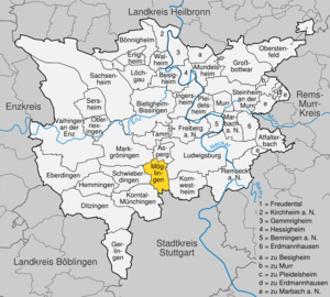
| Location of the community Möglingen in the Ludwigsburg district | ||
  |
||

Möglingen is a municipality in the Ludwigsburg district in Baden-Württemberg . It belongs to the Stuttgart region (until 1992 the Middle Neckar region ) and the European metropolitan region of Stuttgart . The municipality of Möglingen, which has a population of just over 11,000, has no other places.
geography
Geographical location
Möglingen is located between 277 and 309 meters above sea level in the immediate vicinity of the district town of Ludwigsburg on the fertile Langen Feld , which is part of the Strohgäu and the greater natural area of the Neckar Basin . The town center developed around the source of the eastern arm of the Leudelsbach , which joins the Furtbach to the northeast and the Upper Leudelsbach on the western edge of the marking and flows into the Enz at Remminger Knie .
Neighboring communities
Möglingen borders in the north on the city of Asperg , in the east on the district town of Ludwigsburg and its district of Pflugfelden , in the south-east on the city of Kornwestheim , in the south on the Stammheim district of the state capital Stuttgart , in the south-west on the city of Korntal-Münchingen , in the west Schwieberdingen and in the northwest to the city of Markgröningen .
Desolation
Between Moeglingen and Schwieberdingen the late Middle Ages was Outbound village Vöhingen , on Leudelsbach between Moeglingen and Markgröningen formerly Outbound settlement Maulbronn .
Division of space

According to data from the State Statistical Office , as of 2014.
history

Early history
Möglingen was first mentioned in 1275 in a document from the Diocese of Constance and in 1278 as "Meginingen" in a document from Count Ulrich von Asperg. At that time there was already a church in town.
In the 13th century Möglingen was largely in the hands of the Count Palatine of Tübingen- Asperg, who sold their remaining share to the House of Württemberg in 1308 . For the time being, however, the Margraves of Baden still retained some of the lordship's rights over individual goods . The Württemberg counts pledged the place several times, but redeemed it again.

In the Thirty Years' War , especially around 1634, "the number of citizens fell from 130 to 32, that of the mostly ashes of houses from 111 to 22". In the following wars of succession Möglingen was again badly damaged: In 1693 French troops destroyed 35 houses, including the town hall.
Mill and waterworks
The Möglinger Mill at Asperger Straße 18, which was documented for 1523, was operated by Conrad Müller at the time. The Lower Leudelsbach , which was called Mühlbach in 1561 and is now partly overturned , had its origins in the " bet " below the rectory. After a short walk through the village, the Furtbach coming from Pflugfelden flowed into the Leudelsbach from the right, which was then usually strong enough to drive the water wheel of the mill.
In the 17th century there was also a powder mill in Möglingen to supply the Hohenasperg fortress , which was destroyed in the Thirty Years' War - probably in 1634 during the siege of the fortress by imperial troops. 1662, Duke Eberhard III. von Württemberg build a powder mill instead on the much more water-bearing Glems near Markgröningen.
In 1727, the grain miller Caspar Siglin was expropriated at the behest of Duke Eberhard Ludwig in order to set up a water hoist instead of the mill to supply drinking water to the newly established residential city of Ludwigsburg . The water from several sources in the area was collected in a well and pumped to a water tower on the "Löscher". The duke owed due compensation and remuneration and thus plunged many of the affected people into misery. Ten years later, operations were stopped again due to insufficient pumping capacity, high operating costs and line damage. Sabotage is also said to have been involved.
The flour mill, which was rebuilt in 1743, also proved to be uneconomical because of the poor efficiency of the Leudelsbach, which is why it changed hands frequently and was shut down in 1904.
Administrative affiliation
Since the 14th century Möglingen belonged to the Württemberg office of Grüningen , from 1718 alternately to the Oberamt Gröningen, which was dissolved in 1807, and from 1762 to the Oberamt Ludwigsburg . This affiliation did not change with the implementation of the new administrative structure in the Kingdom of Württemberg, founded in 1806, and remained in place until 1934. In 1934 the Oberamt was renamed the Ludwigsburg district.
During the administrative reform during the Nazi era in Württemberg , the community came to the Ludwigsburg district in 1938 . Since the place had become part of the American occupation zone after the Second World War , it had belonged to the newly founded state of Württemberg-Baden since 1945 , which was incorporated into the current state of Baden-Württemberg in 1952.
Railway history
From 1916 to 1975 Möglingen had its own station on the railway line from Ludwigsburg to Markgröningen opened by the Württemberg State Railways , which was used for special trains until 2002 and has been closed since then.
Religions
The local church set came in the 15th century through the brotherhood in Stuttgart to the Stuttgart hospital , which remained the "grand tenor" and owner of the hospital yard and rectory until the 19th century.
With the introduction of the Reformation from 1535 by Duke Ulrich in Württemberg , Möglingen also became Protestant. The place is still predominantly evangelical today. There are also the Old Pietist Community and the Bessarabic Community , both of which cooperate closely with the regional church. But there is also a Roman Catholic community in the village, as well as an Evangelical Methodist one . The New Apostolic congregation was closed at the end of November 2007.
Population development
Before the Thirty Years War the small farming village had 130 inhabitants. In 1858 there were 1136 inhabitants. In particular through the development of the large Löscher residential area in the 1960s, the community experienced a surge in population due to immigration:
- 1618: 130 inhabitants
- 1858: 1,136 inhabitants
- 1955: 2,500 inhabitants
- 1991: 10,130 inhabitants
- 1995: 10,514 inhabitants
- 2005: 10,449 inhabitants
- 2010: 10,617 inhabitants
- 2015: 11,158 inhabitants
- 2017: 11,395 inhabitants

politics
Municipal council
The municipality council in Möglingen has 22 members. The local elections on May 26, 2019 led to the following result. The municipal council consists of the elected voluntary councilors and the mayor as chairwoman. The mayor is entitled to vote in the municipal council.
| Parties and constituencies |
% 2019 |
Seats 2019 |
% 2014 |
Seats 2014 |
||
| FWV | Free voter association Möglingen e. V. | 28.51 | 6th | 21.73 | 5 | |
| CDU | Christian Democratic Union of Germany / Voting Union | 24.01 | 5 | 32.28 | 7th | |
| Green list | Green list for people and the environment | 22.42 | 5 | 15.58 | 3 | |
| SPD | Social Democratic Party of Germany | 20.94 | 5 | 30.41 | 7th | |
| FDP | Free Democratic Party | 4.12 | 1 | 0 | 0 | |
| total | 100.0 | 22nd | 100.0 | 22nd | ||
| voter turnout | 58.39% | 47.73% | ||||
badges and flags
The municipal coat of arms shows a fallen silver hoe and a fallen silver spade crossed diagonally in blue , on the intersection occupied by an eight-spoke silver wheel . The municipality flag is white and blue. The municipality's coat of arms and flag were awarded on June 22, 1967.


Culture and sights
Buildings
- Pankratius Church (Gothic):
- The Möglingen Pankratius Church was evangelically assigned to the Stuttgart hospital after 1534 . During the renovation in 1970/72, frescoes from the 15th century were discovered and exposed again. The church has a Walcker organ that was installed in the sixties. (Geographical coordinates: 9 ° 7'38 "east longitude, 48 ° 53'05" north latitude)
- JUFO, youth forum:
- Erected by young people from Möglingen and by students from the University of Stuttgart under the direction of Siegfried Gaß.
- The Jufo is crowned by a rotatable sun eye that catches the sun in winter and stores it in the heaviness of the clay buildings and, in summer, rotated 180 degrees in a five-minute rhythm following the sun, shading the interior and reflecting solar energy into space.
- Saint Mary:
- Church with a cross that can be illuminated at night
Economy and Infrastructure


traffic
Möglingen is connected to the motorway network at the Ludwigsburg-Süd junction of federal motorway 81 , one kilometer from the town center . The connection to the neighboring towns is established by state and district roads.
Möglingen is located on the disused Ludwigsburg – Markgröningen railway line . A reactivation of the railway line, most recently as a tram route for the Stuttgart trams , has been repeatedly considered, but in the meantime (2014) the track structure is partially overgrown and the tracks on Bahnhofstrasse (across from Edeka ) have already been removed as they prevent traffic on the street disabled. At the moment they are looking for a use for the station building to save it from decay.
Public facilities
There is a retirement and nursing home of the district's own Kleeblatt nursing homes , the youth forum "JUfo" and a library that moved from the historic Zehntscheuer to the new Hanfbach School in 2018 .
education
The community has a primary and secondary school with a Werkrealschule and a special needs school in the Hanfbachstrasse school center, as well as another primary school. Secondary schools are located in Markgröningen and other surrounding cities. There are also three municipal, two Protestant and one Roman Catholic kindergartens, as well as a private kindergarten that works according to Waldorf education .
Supply and disposal
The electricity network in the community is operated by Syna GmbH, a subsidiary of Süwag Energie AG. Stadtwerke Ludwigsburg-Kornwestheim GmbH operates the gas network . The municipality of Möglingen receives all of its drinking water from the Lake Constance water supply .
In 1965 the water tower on the Lange Feld was built for 500,000 marks as a thin-walled shell construction with a hyperbolic shell made of reinforced concrete. The tower has a height of 30 m, a diameter at the base of 9.60 m, a minimum diameter of 7 m, a capacity of 400 m³ and a maximum diameter of 15.50 m. The architect was R. Kessler. Geographical coordinates: 9 ° 08'18 "east longitude, 48 ° 52'18" north latitude.
The Leudelsbach Group Sewage Treatment Association is responsible for wastewater disposal and purification. The Zweckverband has been operating a sewage treatment plant with a capacity of 35,000 EGW near Markgröningen since 1967 . As well as Möglingen, the association's members are the cities of Asperg , Ludwigsburg and Markgröningen . Asperg will take on 15.55 percent of the investment costs due from 2010, Ludwigsburg for the Pflugfelden district 16.3 percent, Möglingen 31.5 percent and Markgröningen 36.65 percent.
The waste is taken from the Abfallverwertungsgesellschaft the district Ludwigsburg mbH (AVL), a 100% subsidiary of the district Ludwigsburg. AVL is commissioned to carry out the tasks of avoiding, recycling and disposing of waste on behalf of the Ludwigsburg district.

Established businesses
The truck manufacturer Scania has a production site in Möglingen and the Württembergische Weingärtner-Zentralgenossenschaft eG (see also Württemberg (wine-growing region) ) is active on site. The USU Software AG has since its inception in 1977 headquartered in Möglingen. The VR-Bank Asperg-Markgröningen is based in Möglingen.
Personalities
Associated with Möglingen
- Edwin Kelm (* 1928), former chairman of the Bessarabian German Landsmannschaft , holder of the Federal Cross of Merit
sons and daughters of the town
- Johannes Hartlieb (around 1400–1468), universal scholar
- Otto Salzer (1874–1944), racing driver, third in the 1914 French Grand Prix (in a Mercedes)
literature
- Albrecht Gühring u. a .: Möglingen - gate to the Strohgäu . Ed .: Municipality of Möglingen. Stuttgart 2000, ISBN 3-923107-09-9
- Oscar Paret : Ludwigsburg and the land around the Asperg: A home book for the district of Ludwigsburg . Ludwigsburg 1934.
- Karl Eduard Paulus : Description of the Oberamt Ludwigsburg . Ed .: Königlich Statistisch-Topographisches Bureau. Stuttgart 1859. Reprint: Bissinger, Magstadt, 1975, ISBN 3-7644-0038-2 , Wikisource .
Web links
- Official website of the municipality
- Information about the history on the website of the Heimatverein Möglingen
Individual evidence
- ↑ State Statistical Office Baden-Württemberg - Population by nationality and gender on December 31, 2018 (CSV file) ( help on this ).
- ↑ State Statistical Office, area since 1988 according to actual use for Möglingen.
- ↑ See Württ. Urkundenbuch Volume VIII, No. 2832, pages 141–142 at WUB online .
- ↑ See Oberamtsbeschreibung Ludwigsburg, 1858, pp. 280 f., At Wikisource .
- ↑ a b See Oberamtsbeschreibung Ludwigsburg, 1858, p. 281, at Wikisource .
- ↑ For the location of the mill, see 48 ° 53 ′ 30.5 ″ N , 9 ° 7 ′ 33.5 ″ E
- ↑ Source: Stock book of the Grüningen office from 1523 (HStA Stuttgart)
- ↑ Source: Albert Kleemann (published in a supplement to the Ludwigsburger Kreiszeitung on December 24, 1968)
- ↑ Source: Hermann and Adolf Seybold (Heimatverein Möglingen 1979)
- ↑ See Oberamtsbeschreibung Ludwigsburg, 1858, p. 275, at Wikisource .
- ↑ [1] Election results at iteos
- ↑ New community school | Möglingen community - a place of well-being in the Stuttgart region. Retrieved April 18, 2019 .
- ↑ Database for structures and civil engineers
- ↑ Ludwigsburger Kreiszeitung: Leudelsbach sewage treatment plant - divers climb into the digestion tower. Edition July 24, 2012
- ↑ Source: Bylaws of the Leudelsbach Group Sewage Treatment Association ( Memento of the original from May 5, 2014 in the Internet Archive ) Info: The archive link was inserted automatically and has not yet been checked. Please check the original and archive link according to the instructions and then remove this notice.

Affalterbach | Asperg | Benningen am Neckar | Besigheim | Bietigheim-Bissingen | Bönnigheim | Ditzingen | Eberdingen | Erdmannhausen | Erligheim | Freiberg am Neckar | Freudental | Gemmrigheim | Gerlingen | Grossbottwar | Hemmingen | Hessigheim | Ingersheim | Kirchheim am Neckar | Korntal-Münchingen | Kornwestheim | Löchgau | Ludwigsburg | Marbach am Neckar | Markgröningen | Möglingen | Mundelsheim | Murr | Oberriexingen | Oberstenfeld | Pleidelsheim | Remseck am Neckar | Sachsenheim | Schwieberdingen | Sersheim | Steinheim an der Murr | Tamm | Vaihingen an der Enz | Walheim