
Remmigheim


Remmigheim , formerly Remichingen , later Remmingen , is a desolate settlement on the sliding slope of an Enz loop south of Untermberg , which today belongs to the town of Bietigheim-Bissingen in the Ludwigsburg district of Baden-Württemberg . After this place the knights named themselves " von Remchingen ".
geography
Settlement factors
The name Remmingen , which is popularly abolished and retained in field names , suggests an Alemannic foundation that has not yet been archaeologically proven. In contrast, the remains of plate graves found in the Lachenwiesen in 1891 document a Frankish settlement in the late Merovingian period (8th century). In the 19th century, according to the description of the Vaihingen office from 1856, the foundations of the former place were still visible, which Bissingen tradition referred to as the "city". Even if this designation seems unfounded, it can be seen as an indication that the former settlement opposite the mouth of the Leudelsbach into the Enz was more important than commonly assumed. The considerable water management interventions as well as the references to the local nobility, castle , church, pilgrim station, fair, raftsman toll and Enz bridge testify to this : all factors that, together with the favorable agricultural location between a loess-covered sliding slope and permanently irrigated meadows, provide the best conditions for prosperity and settlement development to found the city. The desertification is therefore hardly due to economic, but rather to political factors.
Name relics
Until the land consolidations in the 20th century, Remminger roads , each of which led to the former village, could be found on the markings of the northern neighboring towns of Sachsenheim , Untermberg and Bissingen . In Bissingen a Remminger Straße reminds of the place. The lower section of the Leudelsbachtal , which flows into the Enz Valley , is still called the Remminger Valley today , a “half” in the direction of Unterriexingen Remminger Förstle . The pond at the settlement site, protected as a natural monument, is called "Puddle near the former Remmigheim"
In addition, the mixed form "Remmighingen" used in the High Middle Ages gave its name to the ministerial family of Remchingen , for their Remchingen castle , built in the Pfinztal valley , and for the community of Remchingen , which was established in 1973 , an amalgamation of the Baden villages of Wilferdingen, Singen, Nöttingen and Darmsbach in the vicinity of Remchinger Castle .


history
Remmigheim local nobility
From the 11th to the 14th century a local ministerial family can be identified who wrote "von Remmincheim", 1160 "von Remichingin", 1258 "von Remchigen" and 1291 "von Remichain" and had "two crossed glaive sticks" in their coat of arms, that is, glazes with lilies instead of swords, as the draftsman of the coat of arms sketch below apparently assumed. The family mentioned in numerous documents was also wealthy outside Remmigheim, was related to the neighboring local nobility of Sachsenheim , von Riexingen , von Wihingen and the Bietigheim heirs of Venningen and served various feudal lords :
- 1089 appears in the Bempflingen contract "Sigeboto von Remmincheim" - apparently spatially assigned - after the Ministerial Marquard von Grüningen as a witness of Count Werner von Grüningen .
- In 1160, in a document from the Bishop of Speyer for the Maulbronn Monastery, two other ministerials , Heinrich and Wortwin “de Wihingin” ( Enzweihingen ), and some free men are listed as neighboring feudal people of Count Egino von Vaihingen : for example “ Adelbreth de Burfultingin ”( powder things ),“ Sigewart de Uraha ”( Aurich ),“ Wernher de Russewag ”( Roßwag ) and“ Cunrat de Nuzdorf ”( Nussdorf ).
- In 1259, Berthold "von Remichigen" and his alleged brother "Cunradus advocatus" (Vogt von Vaihingen an der Enz see 1271) sealed a certificate from Werner von Nöttingen and his daughters, presumably as son-in-law and future local lord of Nöttingen or lord of the castle according to his gender renamed Remchingen Castle near Wilferdingen . The seal shows two crossed lily wands with the inscription "SIGILLVM BERTOLDI DE REMICHIGEN".
- In 1271, in a document from Count Conrad von Vaihingen, the three brothers "Berhdoldus", "Cunradus" (Vogt) and "Swenegerus" are listed as "domini" "de Remichingen"; so no longer as ministerials, but as barons. Meanwhile Berthold could with his brothers as may Ganerben the property of Castle Remchingen in Pfinztal have come.
- In 1291 in Vaihingen a “Conradus de Remichain”, probably the aforementioned Vogt, testifies to a document from the Count of Vaihingen together with “Hermannus de Sahsenhain”, “Eberhardus de Tamme” and others.
- In 1317 the Grüninger Heilig-Geist-Spital sold to Berthold von "Remenkein", citizen of Vaihingen and probably a son of the late Vogts Konrad, Gülten vom Zehnten in Weihingen (Enzweihingen) as well as a vineyard and a field in Vaihingen.

The outlined coat of arms is said to come from the Remming local nobility, but corresponds to that of the Wihinger

Coat of arms of the Wihinger (Enzweihinger) local nobility in the Horrheim church
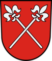
Remichingen coat of arms with crossed glazes (first documented in 1258)

Crest of the related Lords of Venningen that the Ganerben in Bietigheim included


Castle of the local nobility
A castle stable, popularly known as “ Schlössle ”, on the opposite steep slope of the Enz (location: ⊙ ) is believed to have come from this noble family. In addition to the course of the marking boundary, the choice of location also speaks for this, as from here one could not only see the Enz crossing, the village and the Flößergasse, but also the Enz upstream and downstream as well as the country roads parallel to the Enz and to Großsachsenheim. In addition, one had direct eye contact with the relatives' castles in Unterriexingen and over Untermberg .
Old paths and paths lead from the castle stable, which is still recognizable today, not only over a bridge to Remmigheim, but also straight to Bissingen, Brachheim (abandoned settlement with a castle near Tamm ) and Grüningen (today Markgröningen ) as well as to the Schluesselburg and Unterriexinger Castle .
Change of ownership
The departure of the local ministerial family could be related to the 14th century sales of goods by their economically troubled Vaihingen liege lord to the Counts of Oettingen and Württemberg . From 1356 the relics of the Vaihingen county, including the castle and town of Vaihingen, were almost completely in Württemberg hands. At that time, the new feudal lords gave the Remmigheim fief to the Lords of Sachsenheim .
The manor house of the former local aristocracy and the associated 47 hectare land holdings were preserved and are named in the warehouse records of the Großsachsenheim office in 1471 as the “former ancestral farm of the Lords of Sachsenheim ”. This designation suggests that the Counts of Württemberg chose the Lords of Sachsenheim to be the successors of the Remmigheim family as fiefs due to family reasons. Because of the political turmoil and devastation in the 16th century, the village could have been relocated to the manor seat of Altsachsenheim , which offers protection and refuge . The Landesdenkmalamt considers it likely that the Lords of Remmingen built the Altsachsenheim Castle and thus themselves initiated the relocation of the village.
Flößergasse with weir and mill
In February 1342 between Margrave Rudolf IV of Baden and Count Ulrich III. The contract concluded by Württemberg , which regulated the rafting between the Black Forest and Heilbronn , lists Remmigheim with a weir, "at which driving on the Floßgasse had to be paid for with four Heller ". This former weir next to the "Old Raftsman Canal", which still exists today, suggests that there was not only a toll station here, but also a Remminger mill.
Own church
Count Eberhard II of Württemberg enfeoffed a lord of Sachsenheim in 1364 with the patronage of "the Church of Bissingen and Remmigheim". It remains unclear whether this meant a common church or a separate church. In 1422, however, the Sachsenheim barons sold the Bissingen church to the Grüninger Heilig-Geist-Spital . And according to Leo BW , a Remmigheim church was first mentioned in a document in 1394. The last reference comes from May 1533, when Reinhart von Sachsenheim regulated the tenant law conditions for some goods lent in connection with the sacristan service at the Church of Sankt Jakob zu Remmigheim. According to Hoffmann , it also served as a pilgrimage church on the Way of St. James . There was also a fair at the parish fair. According to Hermann Luithle from the Bietigheim-Bissingen History Association, who tried to support his field research with archival materials, the church was in the “Brücklesäcker” area, where stones and relics of a fence were found in the 20th century, to which the field name “ Haagäcker ” refers.
In 1394, the lords of Sachsenheim held half of the church set as a Württemberg fief. The other half may already have belonged to the Grüninger Hospital.
Desolation
It is still in the dark when Remmigheim actually fell . In any case, income from “Remmigheim” is still booked in the hospital bills of the Grüninger Heilig-Geist-Spital from 1444/45. In 1468 the Lords of Sachsenheim awarded a “Höflein” to Remmigheim. And in the matriculation lists of the University of Tübingen there is a “Johannes Hipp de Remingshain” in 1498, “Joannes Sarctor Remingheimensis” in 1564 and a “Joannes Bisinger Remingsheimensis” in 1588, which are more likely to come from Remmingsheim near Rottenburg am Neckar . The latter could actually come from Remmigheim near Bissingen because of his family name, especially since he reappeared in 1597 as a deacon in the neighboring city of " Gröningen ". “Reynhardus Remmichinger von Remmichingen in the Diocese of Speyer ”, who matriculated in Heidelberg in 1495, was undoubtedly from Remmingen .
In Untermberg , on the other hand, it is assumed that at this time a change of location to Untermberg below the Altsachsenheim Castle had already taken place, as the name genesis of this neighboring town was linked to Remmingen unter dem Berg , first mentioned in 1444 . Over time, "Remmingen" should have dropped out of the place name. On the other hand, this choice of name for the second settlement site could also indicate that the original location was still inhabited for a while and the addition “under the mountain” served to differentiate the two locations. This thesis is supported by the fact that at least the church still existed in 1533. Late 16th century Remmigheim however, was finally disposed of what the 1575 by Heinrich Schweickher created map the "Grein Inger Beamptung" shows: the former Sachsenheimer territory that you temporarily transferred after the extinction of this generation (1561) Grüninger Office had included Remmigheim is no longer shown.
The Remmigheim marker fell to Untermberg. In 1682 the Burgstall and the hillside forest underneath (today Bannwald Rotenacker ) were known as "Gröninger Rauttenacker", however, owned by the city of Grüningen. Before 1831 (see Urflurkarte from 1831/32) these areas must finally have come to Untermberg.
According to Luithle, the names of the three Remminger Zelgen “See”, “Hälden” and “Wolfsbühl” remained in use after they were farmed from Untermberg. Except for the Remminger Weg corridor, this should also apply to most of the field names.

The "Türmle" - a relic from Remming's time?
It is possible, however, that not everything was lost in the course of the Remming desertification: the two-storey "Türmle" (tower tower), which is still within the Remming boundary, is located at the Untermberg herb garden settlement . Its nickname "Mäuseturm" is said to come from " Maut " ( right of escort ) on the nearby postal route , which led from Großsachsenheim over the Remmigheimer bridge and through the Remminger valley to Grüningen . The stone building on the arch of the door, built or renovated in 1574, probably served as an observation, security and signal post in the past . Accordingly, it must have been created during the time of Count Eberhard von Württemberg , who had the north-western border secured against the hostile Count Palatine Friedrich, or as early as the 14th century, when the Württembergians fought against the Sachsenheimers. In other words, in times when Remmigheim still existed and the Sachsenheim dominion did not yet belong to Württemberg. The desolation near the tower, which can still be seen today, points to other buildings that were probably initially used to accommodate and take care of the guards stationed here and possibly to change horses after the post office was introduced.
Additional information
swell
- Landesarchiv Baden-Württemberg - Landesarchiv BW online
- Württembergisches Urkundenbuch (WUB) - WUB online
literature
- Otto Bickel: Remchingen. History of its districts and the noble family of that name . Edited by the Mayor's Office in Remchingen. Remchingen 1993. 1012 p.
- Ludwig Friedrich Heyd : History of the former Oberamts-Stadt Markgröningen with special consideration for the general history of Württemberg, mostly based on unpublished sources . Stuttgart 1829, facsimile edition for the Heyd anniversary, Markgröningen 1992. 268 pp.
- Karl Heidinger: The Remminger Way . In: Die Mörin - series of publications by the Association for Local History Sachsenheim , No. 47/48, 2006, pp. 12-13.
- Gustav Hoffmann : Church saints in Württemberg (representations from the history of Württemberg, Volume 23). Stuttgart 1932.
- Markus Otto: The gentlemen of Wihingen and the relatives of the gentlemen from Remmigheim - lecture on February 22, 1991 . In: Südwestdeutsche Blätter für Familien- und Herappenkunde - 20. 1991/93. Pp. 89-91.
- Willi Müller: An extraordinary story of the brand: Untermberg alias "Sachsenheim vnderm Berg" alias "Remmickheim vnder dem Berg" . In Hie gut Württemberg 34, 1983, pp. 17-19.
- Karl Eduard Paulus : Description of the Oberamt Vaihingen . Edited by the Royal Topographical Bureau . Stuttgart 1856. Wikisource .
Remarks
- ↑ Composite of sheets NO XL / 2 + 3, NO XLI / 2 + 3 and NO XLII / 2 + 3 of the Urflurkarte from 1832 . Source: State Archives Ludwigsburg .
- ↑ Other medieval spellings were 1160 "Remichingin", 1258 "Remchigen", 1287 "Remenkein", 1291 "Remichain", 1296 "Remmenkein" and 1495 "Remmichingen". To this day, the -ingen and -heim -form have been preserved in linguistic usage. See regional history portal Leo BW
- ↑ Ingo Stork zu Untermberg / Remmigheim in Pre- and Early History in the District of Ludwigsburg , ed. from the district of Ludwigsburg, Ludwigsburg 1993, p. 161.
- ↑ Description of the Oberamt Vaihingen , p. 237f. ( P. 237 online , p. 238 online )
- ↑ Explanation of the term " Hilder" : Swabian term for a wooded slope.
- ↑ Location see 48 ° 55 '43.5 ″ N , 9 ° 4 ′ 47.5 ″ E
- ↑ See documentation of the castle renovation in the database of the Baden-Württemberg State Monuments Office .
- ↑ The crossed glaive rods are first documented for 1258 in a seal by Berthold from "Remichigen". See WUB Volume V., No. 1463, pp. 228-229 - WUB online .
- ↑ Source: Helmut Orth, On the trail of the former Remmigheim , in: Bietigheimer Zeitung of July 16, 1994.
- ↑ The search in WUB online yielded 30 hits.
- ↑ See Markus Otto, The Lords of Wihingen and the family members of Remmigheim - lecture on February 22, 1991 , in: Südwestdeutsche Blätter für Familien- und Wappenkunde 20, 1991/93, pp. 89–91.
- ^ The first verifiable feudal lord was Count Werner von Grüningen. This was probably followed by the Counts of Ingersheim and Calw and the Counts of Vaihingen as their successors. The Counts of Oettingen, von Eberstein and the Margraves of Baden can also be found.
- ↑ See Stefan Schipperges, Der Bempflinger contract of 1089/90 , Esslingen 1990, p. 113
- ↑ Source: HStA Stuttgart (A 502 U 9), text in WUB Volume II, No. 374, pp. 132-134 - WUB online .
- ↑ Source: WUB Volume V., No. 1513, pp. 281–282 WUB online
- ↑ Source: WUB Volume VII., No. 2187, p. 124 - WUB online
- ↑ Source: WUB Volume IX., No. 4143, pp. 474–475 - WUB online
- ↑ Source: HStA Stgt. A 602 No. 8887 = WR 8887 - Landesarchiv BW online
- ↑ 1258 first attested as the seal of Berthold's "de Remichigen". Source: WUB Volume V., No. 1463, pp. 228–229 - WUB online
- ↑ Location coordinates of the Remminger Schlössle castle stables : NS = 48.9261 EW = 9.0822
- ↑ Relics of a ramp at "Tammer Badplatz" and the field name "Brücklesäcker" are evidence of a bridge to the " Werth " and another over the "Altarm" to the place.
- ↑ In 1463 the brothers Hans and Conrad von Sachsenheim confer "on Hänßlin Buß von Bissingen a farm in Remmigheim as inheritance". Source: HStA Stgt. H 101/21, Volume 1, 3 (Sheet 242v / 326v) Landesarchiv BW online
- ↑ Source: HStA Stgt. H 101/21, Volume 1, 3 (Sheet 519v / 794v) - Landesarchiv BW online
- ↑ See documentation of the castle renovation in the database of the Baden-Württemberg State Monuments Office .
- ↑ Source: HStA Stgt. A 99 U 3 Landesarchiv BW online
- ↑ See Ludwig Friedrich Heyd , History of the former Oberamts-Stadt Markgröningen with special regard to the general history of Württemberg, mostly based on unpublished sources , Stuttgart 1829, p. 31, and Oberamtsbeschreibung Vaihingen, p. 238 Oberamtsbeschreibung Vaihingen .
- ↑ Ludwig Friedrich Heyd: History of the former Oberamts-Stadt Markgröningen with special consideration for the general history of Württemberg, mostly based on unpublished sources . Stuttgart 1829, facsimile edition for the Heyd anniversary, Markgröningen 1992, p. 31.
- ↑ See regional history portal Leo BW
- ↑ Source: HStA Stgt. A 397 U 6 Landesarchiv BW online
- ^ See Gustav Hoffmann : Church saints in Württemberg (representations from the history of Württemberg, Volume 23). Stuttgart 1932.
- ↑ See Helmut Orth, On the trail of the former Remmigheim , in: Bietigheimer Zeitung of July 16, 1994.
- ↑ Ludwig Friedrich Heyd: History of the former Oberamts-Stadt Markgröningen with special consideration for the general history of Württemberg, mostly based on unpublished sources . Stuttgart 1829, facsimile edition for the Heyd anniversary, Markgröningen 1992, p. 229.
- ^ Heinrich Hermelink : The registers of the University of Tübingen: 1477–1600 . Leipzig 1906, pp. 119, 419 and 659. Digitized
- ^ Gustav Toepke : The register of the University of Heidelberg from 1386 to 1662. Heidelberg 1884, p. 417 Heidelberger Matrikel online .
- ^ History of the village of Untermberg. (No longer available online.) Sympathy for Untermberg e. V., archived from the original on December 11, 2013 ; accessed on February 1, 2014 . Info: The archive link was inserted automatically and has not yet been checked. Please check the original and archive link according to the instructions and then remove this notice.
- ^ According to Ludwig Friedrich Heyd: History of the former Oberamts-Stadt Markgröningen with special consideration for the general history of Württemberg, mostly based on unpublished sources . Stuttgart 1829, facsimile edition for the Heyd anniversary, Markgröningen 1992, p. 31 f., But later the terms "Sachsenheim unterm Berg" and "Bissingen unterm Berg" were also used - depending on the perspective of the namesake.
- ↑ The map only shows locations within the official area. Source: HStA Stgt. N1 No. 70, Bl. 13 (fol. 11); see Fig. "Greininger Beamptung" and picture above.
- ↑ The contract of 1342 (see Ludwig Friedrich Heyd: History of the former Oberamts-Stadt Markgröningen with special consideration for the general history of Württemberg, mostly based on unprinted sources . Stuttgart 1829, facsimile edition for the Heyd anniversary, Markgröningen 1992, p. 31 f. , and OAB Vaihingen, p. 238) confirms that the Bissinger "Sägmühle" originally belonged to the Remmigheim branding.
- ↑ See Kiesersche forest map No. 159 (Gröningen) and 110 (Unterriexingen) from 1682/84, Composit at Wikimedia Commons
- ↑ See addendum by Hermann Luithle to the article by Helmut Orth, On the trail of the former Remmigheim , in: Bietigheimer Zeitung of July 16, 1994.
- ↑ See location description at LEO BW
- ↑ At that time, for example, the people of Württemberg had the moat built and also strengthened the fortifications of the Reichsburg Grüningen .
- ↑ Orth made similar assumptions. See Helmut Orth: Bissinger Steindenkmale , in: Ludwigsburger Geschichtsblätter , No. 36, 1984, pp. 85-113.
- ↑ See württ. Urflurkarte NO XLII, sheet 2, from 1832, source: State Archives Ludwigsburg (LABW) .
See also
- Burgstall Remminger Schlössle
- Ministerial family of the Lords of Remchingen
Web links
- Commons : Remmigheim - collection of pictures, videos and audio files
- Commons : Remchingen (noble family) - Collection of images, videos and audio files
- Regional history portal Leo BW
- History of the village of Untermberg
Coordinates: 48 ° 56 ' N , 9 ° 5' E