
Löchgau
| coat of arms | Germany map | |
|---|---|---|

|
Coordinates: 49 ° 0 ' N , 9 ° 6' E |
|
| Basic data | ||
| State : | Baden-Württemberg | |
| Administrative region : | Stuttgart | |
| County : | Ludwigsburg | |
| Height : | 260 m above sea level NHN | |
| Area : | 10.95 km 2 | |
| Residents: | 5608 (December 31, 2018) | |
| Population density : | 512 inhabitants per km 2 | |
| Postal code : | 74369 | |
| Area code : | 07143 | |
| License plate : | LB, VAI | |
| Community key : | 08 1 18 047 | |
| LOCODE : | DE LCA | |
| Address of the municipal administration: |
Hauptstrasse 49 74369 Löchgau |
|
| Website : | ||
| Mayor : | Robert Feil | |
| Location of the community of Löchgau in the Ludwigsburg district | ||
  |
||

Löchgau is a municipality in the Ludwigsburg district . It belongs to the Stuttgart region (until 1992 the Middle Neckar region ) and the European metropolitan region of Stuttgart .
geography
Geographical location
The municipality Löchgau is located in the southwestern Neckarbecken in part the natural area Metter plate in the relatively flat valley of the Enz ongoing Steinbach , the little leads to the municipal boundary in the eastern neighboring town.
Community structure
The community of Löchgau includes the village of Löchgau, the hamlet of Weißenhof and the Petershöfe homestead.
Neighboring communities
The municipality of Löchgau borders in turn on the municipalities of Freudental in the north-west, Erligheim in the north, the city of Bönnigheim in the north-northeast and the municipality of Walheim in the northeast, and further on to the cities of Besigheim in the southeast, Bietigheim-Bissingen in the south and Sachsenheim in the southwest. All neighboring communities are also in the Ludwigsburg district.


Division of space

According to data from the State Statistical Office , as of 2014.
history
timeline
The first documentary mention of Löchgau can be found in a forged deed of donation . It is documented that the Bishop of Speyer gave the Peterskirche von Löchgau to the Maulbronn Monastery in 1147 after he had previously bought it from a nobleman named Beringer who was resident in Löchgau. In 1244 the Maulbronn Monastery handed over the church in Löchgau to the Speyer Cathedral Monastery.
In 1484, the Electoral Palatinate quarter of Löchgau came into Württemberg ownership when it was exchanged for the Württemberg portion of Ingersheim . In 1506, Duke Ulrich von Württemberg acquired another quarter of the village from Konrad Schenk von Winterstetten in exchange for Freudental . In 1529, Margrave Philipp I of Baden bought his possessions in and around Besigheim back and received half of the village of Löchgau. Until 1595 Löchgau was half Baden, half Württemberg.
In 1530 the elliptical village wall with the moat in front of it and three gate towers were first mentioned in a document. In 1984 the remains of the wall were designated as a cultural monument.
In 1534 Löchgau became Protestant.
In 1579 the tithe barn was built by the Speyer Cathedral Monastery.
In 1595 Duke Friedrich I of Württemberg bought the second half of Löchgau together with the Baden offices of Mundelsheim and Besigheim from Margrave Ernst Friedrich von Baden-Durlach , so that Löchgau, which thus belonged to the Besigheim office, now came fully into the possession of Württemberg.
From the beginning of the 17th century at the latest , a cellar built from field stones , partly above ground, which once belonged to the Gasthaus Krone . The cellar is located outside the town walls opposite the Krone , on what will later be the area of the Gasthaus Sonne , west of the state road. Since the cellar was close to the Wette , a shallow crossing of the Steinbach, which was used as a ford or horse washing and watering place, it could not be set deep in the ground.
Initially, the Löchgau town hall was located in Brunnengasse, until a two-story half-timbered building was built in Hauptstraße in 1602.
In 1604 the parish barn was built, which, like the tithe barn, burned down due to a lightning strike in August 1686, but was rebuilt a year later.
The Thirty Years War lasted from 1618 to 1648 , during which 110 families died out in Löchgau.
From 1650 Löchgau belonged exclusively to the Bietigheim office and had to pay all taxes there.
The hamlet of Weißenhof, two kilometers south of Löchgau, came into being in 1739 when two brothers from Löchgau, Jakob and Hans-Jörg Weiß, built their farm on the ruins of a former Roman estate. On November 3, 1799, French troops threatened the city of Ludwigsburg near Löchgau, but were repulsed by Austrian troops.
In 1802 a bridge was built over the Steinbach at the Wette and the two western gates demolished. The large betting area next to the Gasthof Sonne and below the wine press, which was first mentioned in documents in 1407, was used as a wine trading point. The bet could well Deicheln the town lying west by a Brunnenstube be supplied.
In 1806 the old Württemberg town of Löchgau became part of the newly founded Kingdom of Württemberg .
In 1810, Löchgau came to the Oberamt Besigheim in accordance with the new administrative structure of Württemberg .
From 1816 to 1817, many people from Löchgau emigrated because of a famine that occurred in the year without a summer .
In 1819 the Gasthaus Sonne was built outside the village wall, opposite the Bietigheimer Tor . The important trade route between Stuttgart and Frankfurt separated the village from the new inn, which served as a hostel for travelers. A barn was built on the cellar that once belonged to the Krone , and the Sun Festival Hall was built on another cellar in 1926 . Both cellars can now be visited as part of a cellar tour.
In 1820 the Besigheimer Tor , the eastern end of the village, was removed. Around 1850 the population rose to the number before the Thirty Years War. In 1851 tithing was abolished.
The nail factory was founded in 1875 .
With the district reform in Württemberg during the Nazi era , the place became part of the Ludwigsburg district in 1938 .
In 1945 the place became part of the American zone of occupation and thus belonged to the newly founded state of Württemberg-Baden , which was incorporated into the current state of Baden-Württemberg in 1952.
In 1970 the bridges leading over the Steinbach in the center of the village were removed, the small gardens in the direction of the Bach were removed and the Steinbach was largely ruined. Part of the town wall also had to give way in favor of the busy Besigheimer Straße.
In 1999, the southern bypass road was built and the Besigheimer Strasse was traffic-calmed.
In August 2011 all the buildings of the Gasthaus Sonne were removed, so that point 2 of the historical village tour no longer exists. Only the two cellars from the 17th and 20th centuries and an outer wall running north along the Steinbach remained from the entire courtyard. The two cellars were provided with a new roof or a porch and maintained. They were demolished in 2016 in favor of a Norma .
Population development
The population figures according to the respective territorial status are estimates, census results (¹) or official updates from the State Statistical Office of Baden-Württemberg ( main residences only ).
|
|
|
politics

Municipal council
The local council in Löchgau has 14 members. The local elections on May 26, 2019 led to the following final result. The municipal council consists of the elected voluntary councilors and the mayor as chairman. The mayor is entitled to vote in the municipal council.
| Parties and constituencies | % 2019 |
Seats 2019 |
% 2014 |
Seats 2014 |
||
|---|---|---|---|---|---|---|
| FW | Free voters Löchgau | 40.62 | 6th | 35.0 | 5 | |
| CDU | Christian Democratic Union of Germany | 36.33 | 5 | 39.8 | 6th | |
| SPD | Social Democratic Party of Germany | 23.05 | 3 | 25.2 | 3 | |
| total | 100 | 14th | 100 | 14th | ||
| voter turnout | 54.5% | 63.42% | ||||
badges and flags
The municipal coat of arms shows the golden capital letter L in blue, a six-pointed golden star at the top left. The municipality flag in the colors yellow-blue was awarded on March 12, 1980.
Culture and sights
Museums
The basis of the technology history museum "Nagelmuseum", which opened in 1998, goes back to the Röcker company's collection of 4,500 nail types . The company produced in Löchgau for almost a hundred years, from 1876 to 1974. Based on this collection, the working group Dorfbild Löchgau has set up a permanent exhibition on the history of the nail and compiled textual and visual evidence related to the nail issue. In addition, a collection of curiosities is shown. Since May 15, 2011, the nail museum has moved into new rooms in the historic courtyard at Oberen Straße 8.
Buildings

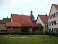
- The Peterskirche was mentioned as early as 1147. The oldest components of the church date from the 13th / 14th centuries. Century, the tower received its present shape in 1756/76. Richard Rensch built the modern organ in 1959.
- Next to the church is the Protestant parsonage , the vaulted cellar of which is dated to 1746 and behind which there is the tithe barn from 1576, to which the parish barn was added in 1604 .
- The historic center around the church is supplemented by the old schoolhouse , which was built in 1852 instead of the first schoolhouse from 1682 and functioned as a school until the 1950s. In its neighborhood there is still a historic house from 1614 with a striking newer arbor from the Art Nouveau period.
- The town hall was built in 1602 using truss technology. The market hall was once located on the ground floor of the building. In 1988 the building was expanded with an extension.
- The village wall was first mentioned in 1530 and is still partially preserved today. This massive fortification is a specialty, as usually only cities were walled, while villages were otherwise only surrounded by wooden fences or hedges.

Rectory from 1746

Tithe barn from 1576

Schoolhouse from 1852

Town house from 1614


- The old wine press was mentioned as early as 1407. The building, which was renovated in 1980, is now a restaurant
- The estate of Colonel Mösel was built around the 1600th The building's bay window was added in 1871 and the stable dates from 1886.
- The historic forge dates back to around 1800.
- The historic inns Krone and Sonne were located on the edge of the historic town center . The Gasthof Krone was built on the remains of the village wall and still houses a restaurant today. The Gasthof Sonne dates from 1819 and was demolished in August 2011 with the exception of the northern outer wall, a cellar built in 1926 from hewn stone, which was located under the sun room and a cellar made of field stones from the early 17th century. In 2015 these buildings will also be demolished in favor of a Norma branch .

Old wine press

Forge around 1800

Mösel manor
Bürgergarten


Sculptures

Löchgau is rich in fountains and sculptures, most of which come from the local artist Karl-Henning Seemann : a crucifixion group on the west gable of St. Peter's Church, the town hall fountain and the sculpture "The Wine Scandal" on the town hall square, the "Lörracher Reiter" and the sculpture " Reinecke Fuchs "at the exit to Besigheim as well as the staircase sculpture in the Bürgergarten and the" Hasenropferbrunnen ".

Crucifixion group in front of St. Peter's Church

Staircase sculpture in the Bürgergarten

Hasenropferbrunnen


Regular events
- Hasenropferfest
- Weißenhoffest
- Löchgau wine village around the market square
- Flight festival Löchgau
- Shopkeeper market - one market each in spring and autumn
Economy and Infrastructure
Löchgau is a wine-growing place whose vineyards belong to the large Schalkstein site in the Württemberg lowlands of the Württemberg wine-growing region .
traffic
There is a glider airfield in Löchgau.
Public facilities
There is a retirement and nursing home of the district's own shamrock nursing homes . The municipality of Löchgau runs the three kindergartens in Birkenweg, Lilienweg and Beethovenstraße, as well as the Hasennest children's home in Schulstraße.
Supply and disposal
The electricity and gas network in the community is operated by Netze BW GmbH. The drinking water is obtained from the Besigheim water supply group.
Personalities
Sons and daughters of the church
- Jakob Löffler (1582–1638), Württemberg Chancellor
- Johann Conrad Creiling (1673–1752), professor of mathematical sciences and natural philosophy in Tübingen, miracle doctor
- Heinrich Michael Edelmann (1806–1874), Württemberg's deputy war minister
- Wilhelm Bechtle (1906–1971), politician ( KPD , MdL Baden-Württemberg )
- Reinhold Bechtle (1907–1938), died in Welzheim concentration camp, Schneider, KPD member, resistance fighter against the Nazi dictatorship
Other personalities associated with the community
- Christoph Fahrner (1616–1688?), Mayor of Löchgau, Speyer cathedral monastery conductor, remedy manufacturer and chemist
- Gustav Hoffmann (1875–1952), Protestant pastor, historical researcher
- Karl-Henning Seemann (* 1934), visual artist, professor emeritus at the State Academy of Fine Arts in Stuttgart
- Jochen Rieger (* 1956), German musician, spent his childhood in Löchgau
- Peter Morscheck, part of the Morscheck & Burgmann duo (* 1960), German musician, has lived in Löchgau since 1994
literature
- Thomas Schulz (Ed.): Löchgau - Contributions to Local History , Ludwigsburg 2004
Web links
- Website of the municipality of Löchgau
- History of the village of Löchgau, Richard Karg, manuscript, 1952 (PDF, 508 kB)
Individual evidence
- ↑ State Statistical Office Baden-Württemberg - Population by nationality and gender on December 31, 2018 (CSV file) ( help on this ).
- ↑ Josef Schmithüsen : Geographical land survey: The natural space units on sheet 161 Karlsruhe. Federal Institute for Regional Studies, Bad Godesberg 1952. → Online map (PDF; 5.1 MB)
- ^ Friedrich Huttenlocher , Hansjörg Dongus : Geographical land survey: The natural spatial units on sheet 170 Stuttgart. Federal Institute for Regional Studies, Bad Godesberg 1949, revised 1967. → Online map (PDF; 4.0 MB)
- ^ The state of Baden-Württemberg. Official description by district and municipality. Volume III: Stuttgart District, Middle Neckar Regional Association. Kohlhammer, Stuttgart 1978, ISBN 3-17-004758-2 . Pp. 385-386
- ↑ State Statistical Office, area since 1988 according to actual use for Löchgau.
- ↑ Stat. Landesamt BW: Population development since 1871 ( page no longer available , search in web archives ) Info: The link was automatically marked as defective. Please check the link according to the instructions and then remove this notice.

Affalterbach | Asperg | Benningen am Neckar | Besigheim | Bietigheim-Bissingen | Bönnigheim | Ditzingen | Eberdingen | Erdmannhausen | Erligheim | Freiberg am Neckar | Freudental | Gemmrigheim | Gerlingen | Grossbottwar | Hemmingen | Hessigheim | Ingersheim | Kirchheim am Neckar | Korntal-Münchingen | Kornwestheim | Löchgau | Ludwigsburg | Marbach am Neckar | Markgröningen | Möglingen | Mundelsheim | Murr | Oberriexingen | Oberstenfeld | Pleidelsheim | Remseck am Neckar | Sachsenheim | Schwieberdingen | Sersheim | Steinheim an der Murr | Tamm | Vaihingen an der Enz | Walheim