
Erligheim
| coat of arms | Germany map | |
|---|---|---|

|
Coordinates: 49 ° 1 ' N , 9 ° 6' E |
|
| Basic data | ||
| State : | Baden-Württemberg | |
| Administrative region : | Stuttgart | |
| County : | Ludwigsburg | |
| Height : | 259 m above sea level NHN | |
| Area : | 6.19 km 2 | |
| Residents: | 2913 (Dec. 31, 2018) | |
| Population density : | 471 inhabitants per km 2 | |
| Postal code : | 74391 | |
| Area code : | 07143 | |
| License plate : | LB, VAI | |
| Community key : | 08 1 18 015 | |
| LOCODE : | DE EXM | |
| Address of the municipal administration: |
Rathausstrasse 7 74391 Erligheim |
|
| Website : | ||
| Mayor : | Rainer Schäuffele | |
| Location of the community Erligheim in the district of Ludwigsburg | ||
  |
||

Erligheim is a municipality in the Ludwigsburg district in Baden-Württemberg . It belongs to the Stuttgart region (until 1992 the Middle Neckar region ) and the European metropolitan region of Stuttgart . Apart from the village Erligheim, no other places belong to the community of Erligheim.
geography
Geographical location
Erligheim is located in front of the eastern foothills of the Stromberg in the western part of the Neckar basin in the flat valley basin of the left upper Ensbach of the Baumbach , which drains into the Neckar in a nearby municipality in the east . The district town of Ludwigsburg is in the southeast, the city of Heilbronn in the northeast, as the crow flies, about 16 km away.
Neighboring communities
Erligheim borders the city of Bönnigheim from the northwest, north to east, the municipality of Löchgau in the southeast and south, and the municipality of Freudental in the southwest . All three are also in the Ludwigsburg district.
Protected areas
Erligheim is in the natural park Stromberg-Heuchelberg and participates on the conservation area spur of the current mount to Boennigheim, Erligheim, Freudental, Lochgau and small axes home and Baumbachtal and at the FFH area Stromberg and Bird Sanctuary Stromberg . There are also three natural monuments in Erligheim.
Division of space

According to data from the State Statistical Office , as of 2014.
history
Erligheim was first mentioned in the Lorsch Codex in a document dated 793. In the High Middle Ages, the lords of Magenheim were the owners. 1388 began as in neighboring Boennigheim the Ganerbentum of place: The Lords of Sachsenheim , Neipperg , Liebenstein and Gemmingen were the joint owners of Erligheim. In 1785 Erligheim came to the Duchy of Württemberg , where it belonged to the Oberamt Besigheim . In 1822 Erligheim became an independent municipality, which came to the Ludwigsburg district when the Oberamt was dissolved in 1938 .
During the Second World War , French troops marched into Erligheim on April 8th. After the war Erligheim took in 155 refugees and displaced persons, mainly in the Aichert development area . Other new development areas are Hinter dem Dorf , Schmerbach , Rosenfeld , Ensbach , Blattwiesen , Kuhäcker and Winterrain II .
Population development
Population figures according to the respective area. The numbers are census results (¹) or official updates from the Baden-Württemberg State Statistical Office (only main residences ).
|
|

Religions
Erligheim has been predominantly evangelical since the introduction of the Reformation in the 16th century . The Johanneskirche in the center of the village shapes the village not only spiritually, but also architecturally. In addition to the evangelical community, there is also a free Christian community in the village. The few Catholic believers, however, are cared for by the Roman Catholic community in Bönnigheim .
politics

Municipal council
After the last local election on May 26, 2019 , the local council has twelve members. The turnout was 61.81%. The choice brought the following result:
| Free Erligheim voter community | 51.04%, | 6 seats | (2014: 7 seats) | |
| Erligheim citizens | 48.96%, | 6 seats | (2014: 5 seats) |
The mayor is the chairman of the municipal council. He is entitled to vote in the municipal council.
mayor
- 1954–1974: Werner Holzwarth
- 1974-2006: Albert Leibold
- since 2006: Rainer Schäuffele
badges and flags
The municipal coat of arms shows a rooted green alder in silver , the trunk is attached with a rising red moon with a face. The municipality flag is green and white. The coat of arms and flag were awarded to the municipality on April 8, 1980.
Partnerships
Erligheim has maintained a partnership relationship with Markersdorf in Upper Lusatia in Saxony since 2001, after constantly deepening contacts since 1990.
Culture and sights
Monuments

- In the center of the village is the Protestant St. John's Church , which has a portal with the year 1740 and a sundial on the outer facade.
- The old town hall next to the Johanneskirche was built in 1749 and was the seat of the municipal administration until 1989. The building, renovated in 1978, is now used for cultural purposes. The local library was also in the building before moving into a renovated half-timbered house in the neighborhood.
- The Vordere Kelter was built in 1772–73 as a Gemminger wine press by the gentlemen of Gemmingen in their quarter of the village right next to the church and used as a wine press until 1952 . Renovations took place in 1980 and 1999, and today the building is a town hall.
- The historic Gasthof Grüner Baum was once also a property of the Lords of Gemmingen.
- The old school house was built in 1850 by the estate owner Johann Friedrich Scheurlen, who donated it to the community in 1854. Today the building is used by the Free Christian Community of Erligheim as a parish hall.
- The current town hall is a modern, functional building from the late 20th century. There is a modern fountain in front of the building and a historic Mainz stone wheel in the building .

Local library

Front wine press

Town hall fountain
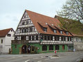
"Green Tree"


Viewpoints

From the wine pulpit on the Erligheimer Kirschberg, a panorama opens up from the Heuchelberg to the Schurwald when the weather is clear.
Economy and Infrastructure
Agriculture still plays an important role in Erligheim , more than 60% of the community area is used for agriculture. Wine is grown on more than 40 hectares, mainly the varieties Blauer Portugieser , Schwarzriesling and Lemberger . There are also around 30 hectares of fruit-growing areas. The Erligheim cherry blossom is known nationwide, around 1200 cherry trees on a contiguous area attract thousands of visitors when the weather is nice.
education
There is a kindergarten and a primary school in Erligheim . A secondary school and all secondary schools are located in Bönnigheim . The Erligheim students also attend secondary schools in the larger cities of Besigheim and Bietigheim-Bissingen .
Supply and disposal
The power grid in the community is operated by EnBW Regional AG. The gas network is operated by Stadtwerke Bietigheim-Bissingen GmbH. The drinking water is obtained from the Besigheim water supply group. The waste is taken from the Abfallverwertungsgesellschaft the district Ludwigsburg mbH (AVL), a 100% subsidiary of the district Ludwigsburg. AVL is commissioned to carry out the tasks of avoiding, recycling and disposing of waste on behalf of the Ludwigsburg district.
Individual evidence
- ↑ State Statistical Office Baden-Württemberg - Population by nationality and gender on December 31, 2018 (CSV file) ( help on this ).
- ↑ State Statistical Office, area since 1988 according to actual use for Erligheim.
- ↑ http://erligheim.de/index.php?id=309 History of Erligheim
- ↑ Population development in Baden-Württemberg from 1871 to 2012 ( page no longer available , search in web archives ) Info: The link was automatically marked as defective. Please check the link according to the instructions and then remove this notice.
Web links

Affalterbach | Asperg | Benningen am Neckar | Besigheim | Bietigheim-Bissingen | Bönnigheim | Ditzingen | Eberdingen | Erdmannhausen | Erligheim | Freiberg am Neckar | Freudental | Gemmrigheim | Gerlingen | Grossbottwar | Hemmingen | Hessigheim | Ingersheim | Kirchheim am Neckar | Korntal-Münchingen | Kornwestheim | Löchgau | Ludwigsburg | Marbach am Neckar | Markgröningen | Möglingen | Mundelsheim | Murr | Oberriexingen | Oberstenfeld | Pleidelsheim | Remseck am Neckar | Sachsenheim | Schwieberdingen | Sersheim | Steinheim an der Murr | Tamm | Vaihingen an der Enz | Walheim