
Stromberg (landscape)
| Stromberg | ||
|---|---|---|
 Stromberg main ridge with Hohenhaslach in the Kirbach valley and telecommunications tower Brackenheim 1 (on the horizon) from the south |
||
| Highest peak | Baiselsberg ( 477.3 m above sea level ) | |
| location | Enzkreis , districts of Karlsruhe , Heilbronn and Ludwigsburg , Baden-Württemberg , Germany | |
| part of | Southwest German step country | |
|
||
| Coordinates | 49 ° 0 ′ N , 8 ° 59 ′ E | |
| Type | Shift level | |
| rock | Keuper , reed sandstone , lower colored marl , upper colored marl , Stubensandstein | |
 The Stromberg west of the Neckar basin |
||

The Stromberg is up to 477.3 m above sea level. NHN high, wooded ridge in northern Baden-Württemberg .
geography
Geographical location
The Stromberg and the north of the river Zaber subsequent Heuchelberg each eponymous part of the 1980 founded the Stromberg-Heuchelberg , the third nature park in Baden-Wuerttemberg.
The Stromberg is mainly in the northwestern district of Ludwigsburg and the northeastern Enzkreis and with its northern foothills also in the districts of Heilbronn and Karlsruhe . It extends about halfway straight line between Pforzheim in southwestern and Heilbronn in the northeast, with its offshoots in the west to Knittlingen and east to Besigheim rich.
division
The Stromberg has an approximately triangular contour. The northern side borders the valley of the Zaber running east to the Neckar , the second is a west-southwest running line from Erligheim at its eastern tip to Mühlacker at the beginning of the eastern course of the lower Enz . From the nearby Ölbronn -Dürrn, the third runs north-northeast to Oberderdingen , which again lies at the intersection with an upward extension of the Zaber.
On the west side of the Stromberg, only short upper streams leave the landscape in a west to north-west direction, which then create larger bodies of water running to the Rhine in the foreland. This narrow western strip of the landscape, which drains along the Rhine, is therefore poorly structured. Most of the Stromberg, however, drains south-southeast to the central Neckar and its left tributaries. In this direction, three large valley axes have formed, which divide the low mountain range into clearly pronounced high ridges themselves:
The largest river in the Stromberg is the Metter , which, after its formation, still curves north of Diefenbach on its upper course and finds its south-south-east central and lower course between Maulbronn- Zaisersweiher and Illingen - Schützingen .
The Kirbach , which arises a little north of the Metter spring and already flows into the Metter outside the landscape in the eastern section of the river, runs almost parallel to this larger stretch of water in the north and is therefore more constant. It is also called Kirchbach or Kirrbach and in the upper reaches Krebsbach.
The shortest of the three landscape structures is the Schmie . It arises in the Maulbronn district of the same name and runs in an almost straight line east- south- east through Lienzingen and Illingen to Vaihingen , where it joins the Enz , which runs east to the Neckar , and which then also receives the Metter almost at the very end in the Neckar basin, before the Stromberg .
The Stromberg is divided into four mountain ranges by these valley axes.
The longest and northern main ridge of the Stromberg runs between Oberderdingen in the west-northwest and Erligheim in the east-southeast. This mountain range is bordered in the north by the valley landscape named after the Zaber , Zabergäu , in the south by the valley of the Kirbach. The Kraichbach rises from the Sternenfels , which is almost on the western end of the ridge, and gave its name to the Kraichgau landscape that adjoins it to the north-west and traversed it . The ridge itself reaches a first height maximum in its course northeast of Häfnerhaslach on the Schlierkopf ( 450.4 m ), further south of Güglingen- Eibensbach on the flat hilltop Scheiterhäule with 472.8 m, its highest point, next to the telecommunications tower Brackenheim 1 stands. Of the heights still following to the east , the largest is the Hohe Reute ( 440.3 m ) above Hohenhaslach .
The middle ridge of the Stromberg branches off from the main ridge to the southeast to the 379.9 m high Gleichenberg northwest of the village of Schützingen ( Illingen municipality ), after which it runs between Diefenbach in the west-northwest and Hohenhaslach (city of Sachsenheim ) in the south-southeast parallel to the main ridge and Kirbachtal in the North-northeast and the valley of the Metter in the south-southwest. Shortly before Hohenhaslach in the Kirbachtal, which is now moving southeast, it rises to the Baiselsberg, the highest point in the entire Stromberg, at 477.3 m . From here it drops off rapidly in the southeast to Sachsenheim.
The southern ridge of the Stromberg is bounded in the north-northeast by the valley of the Metter and in the south-southwest by that of the Schmie. It rises in the west-north-west near Knittlingen , reaches its first peak with the Scheuelberg ( 383.1 m ) south of Freudenstein (city of Knittlingen), which is followed south-south-west of Zaisersweiher (city of Maulbronn) by the Eichelberg ( 366.9 m ) and the Burgberg ( 396 m ) southwest of Schützingen (Illingen municipality). From the now very pronounced ridge, the Schreckstein rises 383.6 m southwest of Gündelbach (city of Vaihingen), it ends on the spur of the Eselsberg ( 392.4 m ), which is located northeast of Ensingen (city of Vaihingen ), which is the highest Elevation of this ridge at its east-southeast end.
Especially from a geological point of view, the Stromberg has a fourth, even southerly and shortest mountain range that extends on the right and south-east side of the Schmie between Ölbronn in the west-north-west and Mühlacker in the east-south-east. Its first elevations are the Ölbronner Eichelberg ( 370.8 m ) and Aschberg ( 333.2 m ), followed by the Sauberg ( 332.4 m ) northeast of Schönenberg and a last summit on the Hochberg ( 315.3 m ) northeast of Mühlacker.
Surveys
The mountains, elevations and their foothills in and on the edge of the Stromberg ridge include:
| Name and special features | location | Height above sea level | |
|---|---|---|---|
| Sorting column south-north | Sorting column west-east | ||
|
Baiselsberg Approx. 500 m south-southeast of the summit of the Baiselsberg monastery ruins Approx. 250 m east-northeast of the summit Burgstall from Burg Bromberg |
49.00380 ° N , 8.9884005 ° O 2.5 km west-northwest ofHohenhaslach |
8,988 | 477.3 m |
| Nameless mountain on the Scheiterhäule plateau with telecommunications tower Brackenheim 1 and nearby Blankenhorn castle ruins |
49.03500 ° N , 8.9960005 ° O 1.4 km south ofEibensbach |
8,996 | 472.8 m |
| Schlierkopf |
49.03245 ° N , 8.9330205 ° O 1.3 km northeast ofHäfnerhaslach |
8,933 | 450.4 m |
| High tail |
49.01192 ° N , 9.0210205 ° O 1.2 km north ofHohenhaslach |
9,022 | 440.3 m |
| Nameless highest point in the pepper forest |
49.02600 ° N , 9.0330005 ° O 1.5 km south ofCleebronn |
9,034 | 431 m |
| Rotenberg |
49.02170 ° N , 9.0409005 ° O 2.5 km south ofCleebronn, 2 km north-northwest ofFreudentaland 3 km northeast ofHohenhaslach.
|
9,041 | 420.9 m |
| Big pig head |
49.02133 ° N , 9.0247105 ° O Halfway about 200 m west of the racing path betweenCleebronnandHohenhaslach.
|
9,025 | 409.2 m |
| Teufelsberg |
49.00422 ° N , 9.0372405 ° O directly east ofHohenhaslach |
9,037 | 402.3 m |
| Castle Hill The mountain takes its name from an abandoned castle mentioned in 1152 . |
48.98641 ° N , 8.8864805 ° O 1.4 km southwest ofSchützingen |
8,885 | 396 m |
|
Michaelsberg with Michaelskirche and Capuchin monastery |
49.03821 ° N , 9.0448005 ° O directly southeast ofCleebronn |
9,046 | 394.7 m |
|
Eselsberg with castle stables and observation tower |
48.97468 ° N , 8.9594005 ° O just northeast ofEnsingen |
8,959 | 392.4 m |
| Scheuelberg |
49.02093 ° N , 8.8266605 ° O 1.5 km south ofFreudenstein |
8,830 | 383.1 m |
| Gleichenberg |
49.01110 ° N , 8.8872005 ° O 2km northwest ofSchützingen |
8,887 | 379.9 m |
| Mettenberg |
49.02014 ° N , 8.8779805 ° O 2 km east-southeast ofDiefenbach |
8,878 | 377.7 m |
| Schlossberg with observation tower. Highest point about 1 km further east, to approximately 410 m , at 49.046 ° N , 8.8659 ° O . There is a water reservoir for the Lake Constance water supply and a radio relay tower. |
49.04890 ° N , 8.8532005 ° O directly southeast ofSternenfels |
8,853 | 375.4 m |
| Gausberg |
48.99920 ° N , 8.9057705 ° O directly north-northeast ofSchützingen |
8,907 | 374.5 m |
| Eichelberg |
48.97649 ° N , 8.7633605 ° O directly southeast ofÖlbronn |
8,764 | 370.8 m |
| Endberg |
49.00741 ° N , 8.8986705 ° O 1.4 km north ofSchützingen |
8,901 | 367 m |
| Eichelberg |
48.99645 ° N , 8.8483705 ° O 1.3 km south-southwest ofZaisersweiher |
8,851 | 366.9 m |
| Sauberg with Sternschanze |
48.97018 ° N , 8.8293605 ° O just north ofSchoenberg |
8,830 | 332.4 m |
| Hochberg |
48.96064 ° N , 8.8783505 ° O directly east ofMühlacker |
8,879 | 315.3 m |
Localities
The localities in and on the Stromberg include:
|
Protected areas
The Stromberg surrounding the same name, in 2007 reported and approximately 10,300 hectares of large European bird sanctuary (SPA) " Stromberg ".
geology

The Stromberg belongs to the layered landscape between the Odenwald, Black Forest and Danube. It was created by reversing the relief from deposits of the Germanic basin . The base is formed by the shell limestone , which is visible in the surrounding gauze landscape. Above that follows a 40 m thick layer of Lettenkeuper , above it a more than 100 m thick layer of gypsum keuper ( Grabfeld formation ), above that a 30 m thick layer of reed sandstone , and above that a layer of lower and upper colored marls that is about twice as thick and at the top a 30-40 m thick layer of parlor sandstone .
The slopes of the Stromberg are relatively steep due to the strong erosion of the soft Keuper and marl layers, while the terrain on the Stubensandsteinplatte runs gently at the top of the ridge. The highest points on the wooded hills often hardly differ from their immediate surroundings.
The steep Keuper flanks on the south side of the hills offer very good conditions for viticulture. In addition, the colorful marls of the higher elevations are brought into the vineyards to further improve the physical properties of the soil: The crumbly disintegrating rock increases the soil's storage capacity for water and heat.
tourism
Since 1993, Kraichgau-Stromberg Tourismus e.V., which emerged from the Stromberg and Kraichgau tourist associations, has been taking care of it . V. around the tourist development of the region.
Worth seeing
The Stromberg offers a well-developed network of hiking and cycling trails. Some of the paths over the wooded plateaus follow old Celtic connecting roads. High-altitude trails on the slope edges of the plateaus offer, depending on the orientation, panoramic views over the lowlands south of the Stromberg to the Swabian Alb or over the valley landscapes of the Kirbachtal, the Mettertal or the Zabergäus.
Other attractions include:
- The Wolfsstein (approx. 390 m above sea level ) set up in the forest near Cleebronn in 1969 , which is a memorial stone to commemorate the slaughter of the last wolf in 1847.
- The observation tower on the Schlossberg near Sternenfels.
- The observation tower on the Eselsberg near Ensingen.
- The adventure park Tripsdrill , a leisure park including a wildlife paradise Tripsdrill near Cleebronn.
- The hamlet of Füllmenbacher Hof , near Diefenbach, and its view from the Füllmenbacher Hofberg to the Stuttgart television tower.
- Near Güglingen- Eibensbach, not far from the highest point of the mountain, the Brackenheim 1 telecommunications tower is located
- The Blankenhorn castle ruins are located about 800 m northeast of its summit .
- The excavation site of the Baiselsberg monastery ruins is located on the eastern slope of the Baiselsberg .
- To the south of Pfaffenhofen , just below the ridge, there is the White Quarry with a viewing platform in front of it. A large number of fossils from the Keuper period were found in the quarry at the beginning of the 20th century.

Wolfsstein from 1969 as a reminder of the killing of the last wolf in 1847
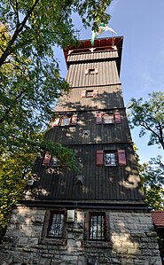
Lookout tower on Eselsberg near Ensingen
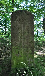
Boundary stone of the Maulbronn monastery on the castle hill above Illingen


Transport links
Approximately in the northwest-southeast direction in the section between Bretten and Vaihingen, the federal highway 35 leads through southern areas of the Stromberg or further south-east past its landscape. In Bretten, the federal road 293, which leads northeast to Eppingen , and the federal road 294, which runs south to Pforzheim, connect to this road. From these federal roads, numerous state and district roads branch off into the interior of the Stromberg.
In addition, the high-speed railway Mannheim – Stuttgart with several tunnels and bridges, the Kraichgaubahn ( Karlsruhe - Heilbronn ) in the northwest and Württembergische Westbahn ( Mühlacker - Bruchsal ) in the southwest run through the Stromberg or past it in a north-west-south-east direction . In the past, the Zabergäubahn ran from Lauffen am Neckar to Leonbronn , which is the western part of Zaberfeld in the transition area between Stromberg and Heuchelberg.
literature
- Dieter Buck: The big book from Stromberg-Heuchelberg. Nature, culture, history, places . 1st edition. Silberburg-Verlag, Tübingen 2006, ISBN 3-87407-704-7 .
- Karl Eduard Paulus : Description of the Oberamt Brackenheim. Edited by the Royal Statistical-Topographical Bureau . H. Lindemann, Stuttgart 1873, Wikisource
- Karl Eduard Paulus: Description of the Oberamt Vaihingen . Edited by the Royal Statistical-Topographical Bureau. Hallberger, Stuttgart 1856. Wikisource
Individual evidence
- ↑ Baden-Württemberg State Office for Geoinformation and State Development: Topographic Map 1: 25000. 6919 Güglingen. 7th edition, Stuttgart 2010, ISBN 978-3-89021-068-1 .
- ↑ Baden-Württemberg State Office for Geoinformation and State Development: Topographic Map 1: 25000. 6920 Brackenheim. 7th edition, Stuttgart 2010, ISBN 978-3-89021-069-8 .
- ↑ Map services ( Memento of the original from December 19, 2012 in the Internet Archive ) Info: The archive link has been inserted automatically and has not yet been checked. Please check the original and archive link according to the instructions and then remove this notice. of the BfN .