Baiselsberg
| Baiselsberg | ||
|---|---|---|
|
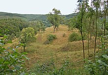
North roof with Bydgoszcz forest and castle stable |
||
| height | 477.3 m above sea level NHN | |
| location | Sachsenheim , Ludwigsburg district , Baden-Württemberg , Germany | |
| Mountains | Stromberg | |
| Coordinates | 49 ° 0 '14 " N , 8 ° 59' 18" E | |
|
|
||
|
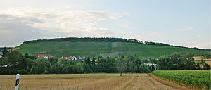
South roofing with vineyards over Horrheim |
||
|
Baiselsberg with Bromberg Castle, Mühle and Rennweg on the south-facing forest map No. 98 from 1684 |
||
The Baiselsberg in the Ludwigsburg district is part of the Stromberg-Heuchelberg Nature Park and is 477.3 m above sea level. NHN the highest point of the Stromberg .
geography
The north-eastern half of the ridge was once part of the markings of the villages of Ochsenbach and Hohenhaslach , and since the municipal reform it has been part of Sachsenheim . The southwest half belonged to the markings of Horrheim , today a district of Vaihingen an der Enz .
The plateau formed by the reversal of relief and its slopes from west to north to east are largely wooded and belong to the Great Fleckenwald and Bromberger Wald . The flatter sloping part of the eastern roof is called Hummelberg . On the steeply sloping southern slope above Horrheim, viticulture is carried out on land-adjusted sites. The elongated ridge of the Baiselsberg was carved out by the Kirbach in the north and by the Metter in the south. Further south-east of the spur of the Baiselsberg, the Kirbach near Sachsenheim , which comes from the north-west, flows into the west-east flowing Metter, which finally flows into the Enz in Bietigheim .
Historical relics
A hiking trail leads over the "summit", which is part of Sachsenheim, on which a sign indicates the "highest point in the Stromberg". It partly runs on a former Rennweg , which led from the southeastern foot of the Baiselsberg towards the Sternenfels . There are other historical relics around the summit:


On a spur of the northern slope encountered in Won Schlössle to the Postal of around 1200 by the noble free men of Bydgoszcz built and 1824 and to the ground worn Castle Bromberg . Down the slope, relics of the former Burgweiler Bromberg am Kirbach can still be guessed, of which only the Bromberg mill , first mentioned in the 12th century, has survived .
About 300 meters south of the Burgstall is the small settlement Kelterle in a north-east running blade , which was built in the 19th century on an apparently older settlement area, in between housed a children's home and today serves the judicial authorities.
About 500 meters south of the highest point, in a clearing belonging to Vaihingen, you can find the restored foundations of the Baiselsberg women's monastery , which was abandoned during the Reformation and then removed.
At the Heidenkopf above the south-west roofing, prehistoric wall relics made of extraordinarily large stones have been preserved, which probably escaped the usual secondary use due to their weight. Speculations that these are witnesses to a megalithic culture that is not yet known in southern Germany has been rejected by the Baden-Württemberg State Office for the Preservation of Monuments .
Web links
- Map of Baiselberg and the surrounding area on: State Agency for the Environment Baden-Württemberg (LUBW) ( information )
- Map of Baiselberg with hiking trails on: Geoportal Baden-Württemberg ( information )
- Image of the summit on flickr.com
Individual evidence
- ↑ Geoportal Baden-Württemberg ( information )
- ↑ See Kiesersche Forstkarte 98 and certificate in WUB online with the noble Ulrich de Branburc (Bromberg) as a witness.
- ^ Fritz Wullen: A forest monastery of the regulated Augustinians in the late Middle Ages. Archival research on the abandoned monastery on the Baiselsberg, Vaihingen-Horrheim, Ludwigsburg district , Historegio vol. 6, Remshalden 2005, 136 pages, ISBN 3-927981-80-X . (including all documents in the original text with translation).


