
Hohenhaslach
|
Hohenhaslach
City of Sachsenheim
|
|
|---|---|
 |
|
| Height : | 233 m |
| Residents : | 2200 (Jan. 1, 2010) |
| Incorporation : | 1st January 1973 |
| Postal code : | 74343 |
| Area code : | 07147 |
Hohenhaslach is a formerly independent wine village in Stromberg , which has belonged to the city of Sachsenheim in the Baden-Württemberg district of Ludwigsburg since 1973 .
geography


Location and structure
Hohenhaslach is located northwest of Ludwigsburg on the southern slope of the Stromberg . The higher situated district is on a mountain spur above the Kirbachtal . The district located in the valley floor was originally an independent church village called Niederhaslach. Mittelhaslach, a third district, lies between Hohen- and Niederhaslach at the foot of the slope.
Neighboring communities
The markings of the following settlements border the former district of Hohenhaslach (clockwise): Bönnigheim , Freudental , Löchgau , the former monastery Rechentshofen and Kleinsachsenheim , Sersheim , Horrheim , Gündelbach , Ochsenbach and Spielberg (all districts of Ludwigsburg ). The related name Häfnerhaslach is located west of Ochsenbach.
At the Bromberger Höfe south of the road to Ochsenbach was the lost castle hamlet Bromberg , from which the Bromberger mill has been preserved.
history
- middle Ages
The Haslahe settlement in the valley was mentioned as early as 800 in the documents of the Lorsch monastery . From 1283 sources for Hohenhaslach are also documented on the mountain. The district of Mittelhaslach was not created until the 19th century; however, a mill in the area of the later district is documented as early as 1317.
In the High Middle Ages Hohenhaslach belonged to the Lords of Eselsberg , who fortified the place. In 1241, Belrein von Eselsberg donated the Cistercian convent Rechentshofen two kilometers southeast of the village. In the same year Hohenhaslach came into possession of the Counts of Vaihingen through marriage . A century later, in 1356, Heinrich von Vaihingen, the last Count of Vaihingen, sold his entire property, including Hohenhaslach, to the House of Württemberg . In the handover documents the place was referred to as a city. The transition to Württemberg was accompanied by a loss of importance; however, the market rights were retained. Until the Reformation , the Hohenhaslach parish belonged to the Vaihingen regional chapter in the Archdiaconate Trinity of the Diocese of Speyer .
In 1304, another women's monastery was founded on the Baiselsberg two kilometers west of the village. This monastery was dissolved in 1550 and then fell into disrepair. The Rechentshofen monastery was also dissolved in the course of the Reformation in 1556 and then initially served as a ducal hunting lodge. Today it is an agricultural estate.
- Modern times
Only a handful of local families survived the Thirty Years War . At the end of the 17th century, the War of the Palatinate Succession again led to high population losses. It wasn't until 1809 that the place recovered. Towards the end of the 19th century, the Kelterle estate was built on the northeastern roof of the Baiselsberg .
The focus on viticulture brought prosperity to the place in the Middle Ages. In the 19th and 20th centuries, however, the one-sided focus on viticulture and the phylloxera crisis meant that the community was ultimately one of the poorest in Vaihingen . After 1945 the cultivation methods were improved, resistant grape varieties were used and the terraces were transformed into slopes so that mechanical processes could be used. Already at the beginning of the 20th century the local winemakers founded a wine cooperative in order to be less dependent on the fluctuating wine prices. In 1969 the Hohenhaslacher and the Bönnigheim winegrowers' cooperative merged to create the Strombergkellerei .
|
|
The coat of arms of Hohenhaslach shows three black stag poles lying on top of each other in a split shield in front in gold, in the back in gold on a green mountain an upright sitting red hare. On February 15, 1956 Hohenhaslach received a flag in the colors red and yellow. |
After Hohenhaslach became part of Württemberg, it belonged to the Vaihingen Office , which became Oberamt in 1758, and finally to the Vaihingen district . With the municipal reform in 1973 Hohenhaslach was incorporated into the city of Sachsenheim on January 1, 1973 and has been part of the Ludwigsburg district ever since.
Attractions

Natural sights
Due to its exposed location on the Stromberg, Hohenhaslach offers a very good view over the Ludwigsburg Unterland to Hohenasperg and to Ludwigsburg itself. On days with good visibility you can see as far as the Swabian Alb . The place is a popular starting point for hikes on the Stromberg or in the Kirbachtal.
Historic Buildings
The parish church of St. George was built around 1230. In 1566 and 1792 the ship was enlarged, and in 1811 the wooden tower spire was renewed. The choir is painted with early Gothic frescoes that were exposed during a church renovation in 1957. They show a Christmas cycle, an Easter cycle and various prophets. In the depiction of the flight into Egypt, Joseph carries a wine barrel. On the north wall frescoes show the conversion of Saul to the apostle Paul and the namesake of the church, the dragon slayer Georg. They date from around 1570.

Parish Church of St. George
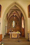
Choir of the parish church


There are three rectories in the immediate vicinity of the church. The oldest was originally the armory, i.e. armory, of the fortified place. In 1605 the building was rebuilt and served as a parsonage from that year until 1775. It is the birthplace of Eberhard David Hauber . The large half-timbered house opposite the armory, built in 1710, served as a parsonage from 1775–1897. Finally, in 1897, the new rectory with its stepped gable was built, directly opposite the west portal of the church on the slope terrace.
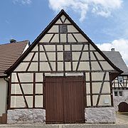
Armory
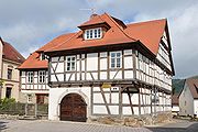
Old rectory, built in 1710

New rectory from 1897


The place also has several other historic half-timbered houses, for example the Gasthaus Ochsen and the clerk's house in the street An der Steige as well as the house in the Küferstraße 16.
Along the slope terrace facing the valley you can still find isolated sections of the old city wall.
Garden railway system

One of the largest garden railways in Germany exists in Hohenhaslach. In this privately owned facility, visitors can put the trains into operation by inserting coins.
Personalities
- Eberhard David Hauber (1695–1765), theologian and geographer.
- Ferdinand Schnaidt (1840–1910), bank director, member of the state and Reichstag.
- Franz Hopf, pastor in Hohenhaslach from 1844 to 1850, fought for democratic conditions.
literature
- Karl Eduard Paulus : Description of the Oberamt Vaihingen . Issued by the Royal Bureau of Statistics and Topography. Hallberger, Stuttgart 1856. Wikisource .
- Peter Schaller (Red.): Hohenhaslach, a wine town. History and stories from 1200 years of village life . City of Sachsenheim (ed.), Sachsenheim 2000.
Individual evidence
- ↑ Source: Württ. Urflurkarte, layer NW XLVII, sheet 2, from 1832, Landesarchiv BW
- ^ Federal Statistical Office (ed.): Historical municipality directory for the Federal Republic of Germany. Name, border and key number changes in municipalities, counties and administrative districts from May 27, 1970 to December 31, 1982 . W. Kohlhammer, Stuttgart / Mainz 1983, ISBN 3-17-003263-1 , p. 453 .
- ^ StA Ludwigsburg, D 39, Bü 79, Landesarchiv BW .
Web links
- Hohenhaslach website near the city of Sachsenheim