
Knittlingen
| coat of arms | Germany map | |
|---|---|---|

|
Coordinates: 49 ° 1 ′ N , 8 ° 45 ′ E |
|
| Basic data | ||
| State : | Baden-Württemberg | |
| Administrative region : | Karlsruhe | |
| County : | Enzkreis | |
| Height : | 196 m above sea level NHN | |
| Area : | 26.33 km 2 | |
| Residents: | 8048 (December 31, 2018) | |
| Population density : | 306 inhabitants per km 2 | |
| Postal code : | 75438 | |
| Area code : | 07043 | |
| License plate : | PF | |
| Community key : | 08 2 36 033 | |
| LOCODE : | DE 78D | |
City administration address : |
Marktstrasse 19 75438 Knittlingen |
|
| Website : | ||
| Mayor : | Heinz-Peter Hopp | |
| Location of the city of Knittlingen in the Enzkreis | ||
  |
||

Knittlingen is a town in the Enzkreis in Baden-Württemberg , about 20 kilometers north of Pforzheim and 30 kilometers east of Karlsruhe on the edge of the Kraichgau in the Stromberg recreation area . It belongs to the Northern Black Forest region .
geography
Geographical location
Knittlingen lies at the transition from the Kraichgau to the Stromberg .
Neighboring communities are from north to south: Oberderdingen , Bretten (both districts of Karlsruhe ), Neulingen , Ölbronn-Dürrn , Maulbronn and Sternenfels (all of them Enzkreis ).
City structure
The city of Knittlingen consists of the three districts Stadt Knittlingen, Freudenstein-Hohenklingen and Kleinvillars . The districts are spatially identical to the earlier municipalities with corresponding names, their official name is in the form "Knittlingen, ...". The city districts also form residential districts within the meaning of the Baden-Württemberg municipal code . In the Freudenstein-Hohenklingen district, a locality has been set up in the sense of the Baden-Württemberg municipal code with its own local council and mayor as its chairman.
The Freudenstein-Hohenklingen district includes the villages of Freudenstein and Hohenklingen, which have both grown together. The village of Kleinvillars is part of the Kleinvillars district. The town of Knittlingen, the Büschlehof farm and the houses Pflegemühle and Störrmühle belong to the Knittlingen district. The deserts Weisach, Oberhofen and Altenhofen are located in the Knittlingen district .
history

The place, founded in Franconian times, is mentioned in a document for the year 843 as "Cnudelingen". From the possession of various sacred and secular rulers, including the Margraviate of Baden , the crystallized Monastery Maulbronn finally out as the sole owner.
In 1188 an allodium (dt .: own property) in Cnudilingen is mentioned in a contract between Emperor Friedrich I Barbarossa and King Alfons VIII of Castile , in which the marriage of Friedrich's son Konrad with Alfons daughter Berengaria was agreed. This own property, which is believed to be in Knittlingen, was part of the bride's morning gift along with 29 other Hohenstaufen goods . However, this marriage was never put into practice.
In 1490, the Roman-German King and later Emperor Maximilian I set up Europe's first regular postal route between Innsbruck and the Netherlands . Knittlingen is occupied as a post office in 1495 and 1499. Abandoned as a post office in 1499, it became a station again in 1563 and replaced Diedelsheim near Bretten . The postal connection brought a lot of life to the small town.
Knittlingen was completely destroyed in 1360, 1632 and 1692 and otherwise suffered a lot from sieges, fires and looting. Count Palatine Philipp moved from here on May 10, 1534 with his troops to Lauffen and moved into camp in the Wiesental and Seugbergen mountains there. In 1632, during the Thirty Years' War , Knittlingen was burned down by the troops of the Imperial General Ernesto Montecuccoli . The important trade route from Frankfurt am Main via Speyer to Cannstatt ran through the middle of Knittlingen.

Knittlingen belonged to the Maulbronn monastery and thus to Württemberg since the beginning of the 16th century . Knittlingen was officially granted town charter in 1840. From 1806, the year the Kingdom of Württemberg was founded , Knittlingen - like its two districts - belonged to the Maulbronn District Office and from 1938 to 1972 to the Vaihingen district . In 1945 the city fell into the American zone of occupation and thus belonged to the newly founded state of Württemberg-Baden , which was incorporated into the current state of Baden-Württemberg in 1952. In 1973 the district reform took place in Baden-Württemberg , when the old Württemberg town of Knittlingen joined the newly established Enzkreis in the Karlsruhe administrative district .
Spatial development of the municipal area
Today's town was re-formed on August 9, 1975 by the merger of the town of Knittlingen and the municipality of Freudenstein. As early as February 15, 1972, the previously independent community of Kleinvillars was incorporated into Knittlingen. Großvillars , which partly belonged to Knittlingen, came completely to the municipality of Oberderdingen on January 1, 1973 .
Religions
Christianity
The religious life in Knittlingen is very diverse. In addition to three responsible for the various districts
- Protestant congregations and one
- Roman Catholic Parish Holy Spirit are also the
- Methodist Church and the
- New Apostolic Church (this with two congregations) represented.
- Parish of Knittlingen
A church is mentioned for the first time as early as 1148. In 1422 it was called St. George's Church. It was outside the city and was probably early parish church for Knittlingen, Diefenbach and Freudenstein as well as for Maulbronn. In 1289 it was incorporated into Maulbronn Monastery. After the church was destroyed, it was demolished in the 18th century. In the center of the town there was a chapel which was dedicated to Our Lady, John the Baptist and John the Evangelist. After the Reformation it became the main Protestant church in the city. The nave and the tower are from the 13th century, the choir is late Gothic.
- Parish Freudenstein
The parish of Freudenstein (around 1,000) comprises the districts of Freudenstein and Hohenklingen of the city of Knittlingen. The church of St. Gallus (so from 1601) was a feudal fief of the Weißenburg family. The current church was built in 1753. There is a late Gothic branch church in the Hohenklingen district.
- Parish of Kleinvillars
The parish of Kleinvillars comprises the Kleinvillars district of the city of Knittlingen. The place is a Waldensian settlement that emerged from 1699 on the suburbs of the city of Knittlingen and the community of Ölbronn. A church was only built in 1737. Politically, Kleinvillars formed a municipality with the neighboring Großvillars until 1826, when it became an independent municipality. The initially Reformed parish of Kleinvillars was incorporated into the Württemberg regional church at the beginning of the 19th century. Since 1876 the place has been looked after by the neighboring parish of Ölbronn.
Denomination statistics
According to the 2011 census , almost half of the population belonged to the Protestant churches; In 2011, 48.5% of the population were Protestant , 19.3% Roman Catholic and 32.2% were non-denominational , belonged to another religious community or did not provide any information. The number of Protestants and Catholics has fallen since then. Currently (as of December 31, 2019), 3,419 (42.1%) of the population are Protestant, 1,449 (17.8%) Roman Catholic and 3,251 (40.1%) are non-denominational or belong to another religious community.
Population development
- 1500: 2000 inhabitants (approximate information)
- 1961: 4930 inhabitants, 921 of them in Freudenstein and 277 in Kleinvillars
- 1970: 5988 inhabitants, 1367 of them in Freudenstein and 273 in Kleinvillars
- 1991: 6777 inhabitants
- 1995: 7248 inhabitants
- 2005: 7614 inhabitants
- 2010: 7617 inhabitants
- 2015: 7903 inhabitants
politics

Municipal council
The local elections on May 26, 2019 in Knittlingen led to the following preliminary final result. The municipal council consists of the elected voluntary councilors and the mayor as chairman. The mayor is entitled to vote in the municipal council.
| Parties and constituencies |
% 2019 |
Seats 2019 |
% 2014 |
Seats 2014 |
||
| CDU | Christian Democratic Union of Germany | 39.89 | 7th | 42.56 | 8th | |
| SPD | Social Democratic Party of Germany | 27.20 | 5 | 27.8 | 5 | |
| ALK | Alternative list Knittlingen | 27.69 | 5 | 21.6 | 4th | |
| PWV | Independent voters' association | 2.90 | 1 | 8.1 | 1 | |
| KA | Knittlingen active | 2.31 | 0 | - | - | |
| total | 100.0 | 18th | 100.0 | 18th | ||
| voter turnout | 58.44% | 40.1% | ||||
mayor
Since 1997: Heinz-Peter Hopp
coat of arms
The blazon of the coat of arms reads: "In silver a golden abbot's staff, fastened with two diagonally crossed black wrinkles."
Partnerships
Knittlingen has had partnerships with since June 11, 2010
- Benaoján ( Andalusia ) Spain
- Montejaque (Andalusia) Spain
Economy and Infrastructure
Knittlingen is a wine-growing place in the Reichshalde location. A large commercial area on the B 35, exit Knittlingen-Mitte, is under development.
Knittlingen is the service center for the north-west Enzkreis. There are numerous doctors, dentists, pharmacies, banks and insurance agencies there. There are also numerous shops and discounters in town.
The most important traffic connection is the federal highway 35 ( Illingen - Germersheim ), part of the formerly planned federal highway 80 .
There are also the following additional transport connections:
- B293 Heilbronn - Pfinztal in Bretten (towards Pfinztal) and in Oberderdingen (towards Heilbronn).
- B294 Bretten - Freiburg im Breisgau in Neulingen .
Motorway connection
A 8 Pforzheim -Nord (heading east), (approx. 12 km)
A 5 Bruchsal (north and west), (approx. 20 km)
A 5 Karlsruhe -Nord (towards the south), (approx. 20 km)
train
The Knittlingen-Kleinvillars train stop is located in the Kleinvillars district . It is located on the Württemberg Westbahn and is served by the RB 17, formerly S9 of the Karlsruhe Stadtbahn .
A railway line should also run through Knittlingen itself. This was even prepared until 1920, but then never completed. Prepared embankments and embankments are evidence of the Bretten-Kürnbach route. In addition, there is a station building in Knittlingen that a train never reached.
Knittlingen belongs to the transport association Pforzheim-Enzkreis (VPE); KVV tickets are also valid from and into the KVV area.
education
Knittlingen is the school center for the north-western Enzkreis . With the Dr. Johannes Faust School there is a primary , secondary and secondary school . Students from Maulbronn , Ölbronn-Dürrn , Sternenfels , Neulingen , Ötisheim , Kieselbronn and even from Oberderdingen visit the Knittlinger school center. There is another elementary school in the Freudenstein district. There are also five kindergartens (two parish, two Protestant and one Roman Catholic kindergarten ).
Culture and sights
Museums
Today there is an extensive Faust archive and a Faust museum in Knittlingen .
Buildings
- Faust Museum (Old Town Hall)
- Stone house
- St. Leonhard's Church
- church Square
Stone house

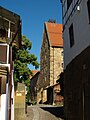
Half-timbered houses on Marktstrasse


Events
- The Fauststadtfest takes place every two years in the historic Marktstrasse .
- On August 11, 2007 the Germany tour drove through Knittlingen . There was also an intermediate time taken there.
Personalities
According to unsecured sources, Knittlingen is the birthplace of the wandering magician, alchemist and fortune teller Dr. Johann Georg Faust .
The successful hit band Die Flippers was founded in Knittlingen . Knittlingen is the residence of Bernd Hengst, the band's former singer and bassist.
sons and daughters of the town
- Johann Georg Faust (around 1480 – around 1541), wandering faith healer , alchemist , magician , astrologer and fortune teller
- Stephan Gerlach (1546–1612), Protestant theologian and preacher
- Ludwig Waaser (1804–1883), lawyer and member of the Württemberg state parliament
- Friedrich Winker (1883–1942), politician (SPD), member of the state parliament from 1919 to 1933
- Eduard Leuze (1906–1973), FDP and DVP politician, Member of the Bundestag , Member of the Bundestag ( Baden-Württemberg ), Baden-Württemberg Minister of Economics
- Adolf Steinhofer (1908–1990), chemist, Chairman of the Board of Management of BASF AG
- Klaus Brodbeck (* 1956), Mayor and District Administrator
- Michael Krauss (* 1983), fistball player
- Sebastian Kienle (* 1984), triathlete (Triathlon Ironman European and World Champion)
Other personalities associated with the city
- Bernd Hengst (born 1947, former member of the music band Die Flippers ), lives in Knittlingen
- Manfred Durban (born 1942, died 2016, former member of the music band Die Flippers ), lived and died in Knittlingen
Individual evidence
- ↑ State Statistical Office Baden-Württemberg - Population by nationality and gender on December 31, 2018 (CSV file) ( help on this ).
- ↑ Main statute of the city of Knittlingen from December 15, 1980, last changed on October 18, 1995 ( page no longer available , search in web archives ) Info: The link was automatically marked as defective. Please check the link according to the instructions and then remove this notice.
- ^ The state of Baden-Württemberg. Official description by district and municipality. Volume V: Karlsruhe District Kohlhammer, Stuttgart 1976, ISBN 3-17-002542-2 . Pp. 543-545
- ^ Peter Koblank: Treaty of Seligenstadt 1188 on stauferstelen.net. Retrieved April 19, 2017.
- ^ Federal Statistical Office (ed.): Historical municipality directory for the Federal Republic of Germany. Name, border and key number changes in municipalities, counties and administrative districts from May 27, 1970 to December 31, 1982 . W. Kohlhammer, Stuttgart / Mainz 1983, ISBN 3-17-003263-1 , p. 491 .
- ^ Federal Statistical Office (ed.): Historical municipality directory for the Federal Republic of Germany. Name, border and key number changes in municipalities, counties and administrative districts from May 27, 1970 to December 31, 1982 . W. Kohlhammer, Stuttgart / Mainz 1983, ISBN 3-17-003263-1 , p. 458 .
- ^ City of Knittlingen Religion , 2011 census
- ↑ [City of Knittlingen data facts], accessed on April 13, 2020
- ↑ History of the Zabergäubahn. In: Zabergäubahn.de. Retrieved December 6, 2019 .
- ↑ Hans-Ulrich Stoldt: Der Mogeldoktor on Spiegel Online from September 29, 2009 [1] .
Web links
- Official website
- Faust Museum
- Shell limestone quarry Störrmühle near Knittlingen
- Weissacher Tal nature reserve

Birkenfeld | Eisingen | Angel Brand | Friolzheim | Heimsheim | Illingen | Ispringen | Kämpfelbach | Pressing | Kieselbronn | Knittlingen | Königsbach stone | Maulbronn | Mönsheim | Mühlacker | Neuenbürg | Neuhausen | Newbies | Niefern-Öschelbronn | Ölbronn-Dürrn | Ötisheim | Remchingen | Star Rock | Straubenhardt | Tiefenbronn | Wiernsheim | Wimsheim | Wurmberg