Hypocritical mountain
| Hypocritical mountain | ||
|---|---|---|
|
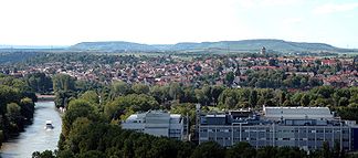
View over Heilbronn- Böckingen to the Heuchelberg in the background |
||
| Highest peak | nameless highest point of the Heuchelberg landfill ( 353 m above sea level ) | |
| location | Heilbronn district , Baden-Württemberg , Germany | |
| part of | Southwest German step country | |
|
|
||
| Coordinates | 49 ° 7 ' N , 9 ° 1' E | |
| Type | Shift level | |
| rock | Keuper , reed sandstone | |
|
The Heuchelberg northwest of the Neckar basin |
||
The Heuchelberg is about 15 km long and up to 353 m above sea level. NHN high ridge a few kilometers southwest of Heilbronn in the Heilbronn district in Baden-Württemberg ( Germany ).
Geographical location
The Heuchelberg and the south of the river Zaber subsequent Stromberg each eponymous part of the 1980 founded the Stromberg-Heuchelberg , the third nature park in Baden-Wuerttemberg.
The Heuchelberg extends in the western part of the Heilbronn district between Leingarten in the northeast and Zaberfeld in the southwest. It is located in the areas of these cities and municipalities (starting clockwise in the northeast): Leingarten, Nordheim , Brackenheim , Güglingen , Pfaffenhofen and Zaberfeld (in the southwest) and Eppingen (only with the Kleingartach district ), Schwaigern and finally Leingarten again.
Landscape image
Like the Stromberg , the Heuchelberg is a Keuper island created by a relief reversal in a loess setting. Its highest elevation is a heaped summit on the Heuchelberg landfill ( 353 m above sea level ), with which an abandoned missile position of the US armed forces was grounded. The highest natural elevation is Heidelberg ( 335.9 m above sea level ) east of the town of Neipperg, which belongs to the city of Brackenheim .
Due to the weathering and erosion of the reed sandstone , the ceiling of the Heuchelberg shows a plateau (on average around 300 m above sea level ) with sharply formed slope edges that tapers towards the east. In the north, the Ottilienberg ( 313.6 m above sea level ) with its ring wall forms an oval high plateau. The ridge and the northern slopes of the Heuchelberg are predominantly forested, the southern slopes are mostly used for viticulture .
mountains
The mountains, elevations or their foothills of the Heuchelberg ridge include - sorted by height in meters above sea level (NHN):
- nameless highest point of the Heuchelberg landfill ( 353 m ), between Stetten and Haberschlacht
- Heidelberg ( 336.7 m ), between Neipperg and Nordhausen
- Hill at the Wolfsgrube ( 335.7 m ), between Stetten and Haberschlacht
- Eichbühl ( 333.7 m ), between Neipperg and Stetten
- Ottilienberg ( 314.1 m ), between Eppingen and Kleingartach ; with ring wall
- Spitzenberg ( 277.5 m ), in Zaberfeld ; with transmission towers and the former Burghalde castle
Worth seeing
The sights of the Heuchelberg include (viewed in northeast-southwest direction): At the northeast end of the ridge, between Leingarten in the northeast and Nordheim in the southeast, the Heuchelberger Warte observation tower ( 315.2 m above sea level ) is visible from afar . The Frankenschanze ring wall system ( 239.5 m above sea level ) spreads out around 300 m north of the observation tower . To the south-west of Leingarten and south-south-west of Schwaigern is the former Fliehburg Harchenburg (also called Old Castle ; 297.8 m above sea level ) in the border area between the two communities . The Rotenbrunnen castle complex (approx. 315 m ) is located around 900 m west-southwest of the Eichbühl between Neipperg and Stetten , and is reminiscent of the nearby Rote Brunnen with its spring. Between Eppingen and Kleingartach there is a ring wall on Ottilienberg and the former castle complex Burghalde on Spitzenberg in Zaberfeld .
Individual evidence
- ^ Keuper "island" Stromberg . In: Stromberg-Heuchelberg Nature Park . Stromberg-Heuchelberg Nature Park eV. Archived from the original on April 24, 2014. Info: The archive link was inserted automatically and has not yet been checked. Please check the original and archive link according to the instructions and then remove this notice. Retrieved April 24, 2014.
- ^ A b Herbert Kaletta: 35,000 trees and a new peak . In: Heilbronn voice from April 11, 2011 . ( http://www.stimme.de/heilbronn/nachrichten/region/sonstige-35-000-Baeume-und-ein-neuer-Gipfel;art16305,2109404 at Stimme.de [accessed on November 9, 2012]).
- ↑ Map services of the Federal Agency for Nature Conservation ( information )


