
Haberschlacht
|
Haberschlacht
City of Brackenheim
|
|
|---|---|
 |
|
| Height : | 228 m |
| Area : | 2.74 km² |
| Residents : | 505 (2009) |
| Population density : | 184 inhabitants / km² |
| Incorporation : | February 29, 1972 |
Haberschlacht is a village in Baden-Württemberg that has belonged to Brackenheim since 1972 .
geography
Haberschlacht is around 230 m above sea level on the southern edge of the Heuchelberg .
history


The origin of Haberschlacht is largely unknown. It is assumed that Haberschlacht was founded in the course of the intensification of viticulture in the Neckarland, probably in the 11th century. The place was first mentioned in a document in 1229. The lords of Magenheim and the Brackenheim city nobility appeared as early landowners in the 13th century, and later the House of Württemberg , the Teutonic Order and the University of Tübingen also received property in Haberschlacht. The sole local ruler was the Duke of Württemberg , to whom the residents of the village were serfs , and who also owned the local wine press , in which the citizens were obliged to press . At the head of the community stood a mayor appointed by the duke . Haberschlacht has always been a vineyard village. The inventory book of 1400 shows around 10 acres of meadows, 31 acres of fields and 60 acres of vineyards. In 1472 an independent parish was established under the Württemberg feudal community for around 40 citizens and their families.
From the late Middle Ages until well into the 19th century, Haberschlacht was a street village : all the houses were located along the village street, in the center only the Kirchgasse branched off to the church and the rectory. The village street was bordered at both ends of the village by a gate that was locked at night, the place was enclosed by a hedge ("ban fence") and a ditch.
In the Peasants' War on the night after Easter Sunday, April 16, 1525, “almost the entire community of Haberschlacht” is said to have been among the rebels who burned the Teutonic Order Castle in neighboring Stockheim . In the 17th century, Haberschlacht suffered from the effects of the Thirty Years' War and the plague . After the Battle of Nördlingen in 1634, Austrian soldiers marauded the area around Brackenheim. Most of the inhabitants of Haberschlacht are said to have fled into the protective Brackenheim city walls, where the plague claimed around 1,600 deaths between 1635 and 1638. The population of Haberschlacht is said to have shrunk to around a fifth of the pre-war level (50 to 60 people from around 300) by the end of the Thirty Years' War. In 1652, 177 of 198 acres of vineyards lay fallow. Due to immigrants, especially Swiss from the Zurich and Bern area, the population rose again to 140 by 1684. In the subsequent War of the Palatinate Succession from 1688, the place was repeatedly visited by French troops, so that by 1694 only 10 citizens were still alive in Haberschlacht. In the War of the Spanish Succession from 1701, war contributions were demanded from Haberschlacht, and troops were billeted again until 1734.

In the 18th and 19th centuries there was reports of great poverty in Haberschlacht. The community itself was indebted after the past war destruction and war contributions. Already in 1712 there was a community property of 720 guilders and a debt of 1,705 guilders. In 1719 a hailstorm devastated the harvest, and in 1725 several people died from starvation. Neither the poverty of the community nor the poverty of the citizens changed in the following century and a half. A report from 1791 describes that 50 out of 80 citizens lacked the necessary clothes “to cover their nakedness”, in 1845 a dean wrote: “The community lives in extreme poverty and begging.” The population grew from around 150 people around 1700 to around 770 people in 1855, afterwards the population fell by half again through emigration and rural exodus.
Haberschlacht had belonged to the old Württemberg office of Brackenheim for centuries . When the new administrative structure was implemented in the Kingdom of Württemberg , which had existed since 1806 , the place remained assigned to the now Oberamt Brackenheim .
In 1837 the old wine press was torn down and a new one built, which also housed the school and town hall under its roof, in 1885 a water pipe for the public wells was laid and a loan association was founded.
In 1903, by the Rev. Edward Wörner with 18 winegrowers, a tenants association in 1905 with 24 wine producers a wine cooperative was founded. The cooperative improved the economic situation of the place immensely. It was registered on November 16, 1905 at the then Württemberg local court in Brackenheim. Due to the scarcity of the First World War, the income from viticulture increased twelve-fold from 1913 to 1917, so that after the 1917 vintage had been marketed, wine growers and the municipal treasury were cleared of debt for the first time in centuries. In 1908 the road to Niederhofen was built, and in 1911 the electrification of the place began. In 1930 the water supply network was relocated and a short-term power post line from Lauffen to Stockheim was set up that touched Haberschlacht. From 1937 to 1938 the new wine press was built in the center of the village by the cooperative.
During the administrative reform during the Nazi era in Württemberg , Haberschlacht came to the Heilbronn district in 1938 .
In 1933 there were 362 inhabitants, in 1939 there were 332. Haberschlacht survived the Second World War undamaged. On April 6, 1945, the place was occupied without a fight by French troops who advanced with tanks from the direction of Niederhofen. Since the place had become part of the American zone of occupation , it belonged to the newly founded state of Württemberg-Baden since 1945 , which in 1952 became part of the current state of Baden-Württemberg. At the end of 1945 Haberschlacht had 394 inhabitants. The population had risen for a short time, in particular due to the quarters of refugees, then stagnated from 1960 to the 1970s at around 350 people.
In 1968 the local sewerage system was laid and the land consolidation, which lasted in three stages until 1979, began. The through-town and the district road to Niederhofen were expanded in 1972, the district roads to Stockheim, Brackenheim and Stetten followed in 1979. Viticulture still shapes the place today.
In 1951 the Brackenheim, Haberschlacht and Neipperg cooperatives merged to form the Brackenheim-Neipperg-Haberschlacht winegrowing cooperative based in Brackenheim. In 1971 the Raiffeisenbank Haberschlacht merged with the cooperative banks in the surrounding area to form Raiffeisen- und Volksbank Brackenheim. Haberschlacht joined the city of Brackenheim on February 29, 1972 as part of the municipal reform and is now the smallest district with around 500 inhabitants.
coat of arms
The coat of arms of Haberschlacht shows an oat plant , with which the coat of arms tries to represent the place name as a "speaking" coat of arms.
Attractions

- The Jakobuskirche has been documented in Haberschlacht since the Middle Ages and received its present form in 1795 through renovation and expansion. The tower dates from Roman times. The historic bells from 1725 and 1869 were melted down in the two world wars, but then replaced again after the wars. The bell was extended by a third bell in 1953.
- Rectory from 1617 with farm building from 1750
- Old wine press (1837) with town hall and school, since 1977 community center
- On the village square there is a historicizing fountain and the sculpture “Man in a Barrel” by Hermann Koziol (1997).
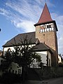
James Church
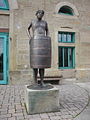
Man in the barrel

Village fountain


Personalities
- Georg Heinrich Seiferheld (1757–1818), inventor, natural scientist and non-fiction author
- Eduard Wörner (1866–1923), pastor, honorary citizen of Haberschlacht 1920 on the occasion of his 20th anniversary of service, namesake of Eduard-Wörner-Straße
literature
- Gerhard Aßfahl: Haberschlacht . In: Home book of the city of Brackenheim and its districts. Brackenheim 1980.
- City of Brackenheim (ed.): Haberschlacht. A wine village in Zabergäu , Brackenheim 2005.
Individual evidence
- ↑ Communications of the Württemberg Stat. State Office No. 4/5 of December 10, 1940: Results of the population and occupational census on May 17, 1939
- ^ Results of the population census and determination of residence on December 4, 1945 in northern Württemberg
- ^ Federal Statistical Office (ed.): Historical municipality directory for the Federal Republic of Germany. Name, border and key number changes in municipalities, counties and administrative districts from May 27, 1970 to December 31, 1982 . W. Kohlhammer, Stuttgart / Mainz 1983, ISBN 3-17-003263-1 , p. 451 .
