
Gemmrigheim
| coat of arms | Germany map | |
|---|---|---|

|
Coordinates: 49 ° 2 ' N , 9 ° 9' E |
|
| Basic data | ||
| State : | Baden-Württemberg | |
| Administrative region : | Stuttgart | |
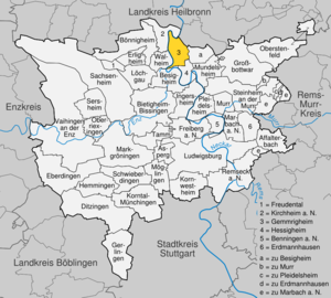
| County : | Ludwigsburg | |
| Height : | 182 m above sea level NHN | |
| Area : | 8.23 km 2 | |
| Residents: | 4351 (December 31, 2018) | |
| Population density : | 529 inhabitants per km 2 | |
| Postal code : | 74376 | |
| Area code : | 07143 | |
| License plate : | LB, VAI | |
| Community key : | 08 1 18 018 | |
| LOCODE : | DE RCD | |
| Address of the municipal administration: |
Ottmarsheimer Strasse 1 74376 Gemmrigheim |
|
| Website : | ||
| Mayor : | Jörg Frauhammer ( SPD ) | |
| Location of the community Gemmrigheim in the Ludwigsburg district | ||
  |
||


Gemmrigheim is a municipality in the Ludwigsburg district in Baden-Württemberg . It belongs to the Stuttgart region (until 1992 the Middle Neckar region ) and the European metropolitan region of Stuttgart .
geography
Geographical location
Gemmrigheim is 174 to 275 meters above sea level directly on the Neckar between the district towns of Ludwigsburg and Heilbronn .
Neighboring communities
The municipality borders in the northeast on Neckarwestheim in the district of Heilbronn , in the east and south on the city of Besigheim , in the southeast on the municipality Hessigheim and in the southwest on Walheim and in the west and north on Kirchheim am Neckar .
Community structure
Gemmrigheim includes the village of Gemmrigheim, the Heinzenberg, Liebensteiner Weg and Vogelsang farms and the Pumpwerk and Wasen houses.
Division of space

According to data from the State Statistical Office , as of 2014.
history
Early history
Various finds from different epochs in Gemmrigheim indicate an ancient settlement of the place. Gemmrigheim was in a document of the monastery Reichenbach of 22 September 1085 was first mentioned and belonged to Gaugrafschaft the counts of Calw-Vaihingen , of which the place in 1140 to the Count Palatine of Tübingen passed and of these about the Hofwart of Kirchheim until the 14th Century to the county of Württemberg , where he belonged to the office Lauffen . A first Württemberg mayor is documented in 1410.
Viticulture in the community has been guaranteed since the 12th century and shaped Gemmrigheim significantly. The place was affected several times in the Thirty Years War and the subsequent military conflicts.
19th and 20th centuries
In the course of the new administrative structure after the establishment of the Kingdom of Württemberg , Gemmrigheim came to the Oberamt Besigheim in 1808 . Industrialization began in Gemmrigheim in 1865, when an old Neckar mill was first expanded into a wood pulp factory and then a paper factory. As a result of the district reform during the Nazi era in Württemberg , Gemmrigheim was assigned to the Ludwigsburg district in 1938 when the Oberamt Besigheim was dissolved .
During the Second World War , the first Polish prisoners of war came to Gemmrigheim in 1939. Although enemy troops bombed the paper mill in an air raid, the village remained relatively unscathed. On April 9, 1945, the Wehrmacht blew up the Neckar Bridge between Gemmrigheim and Kirchheim to prevent the Allies from advancing. American soldiers occupied the place on the 20th of the same month and the war ended in Gemmrigheim. The place became part of the American zone of occupation and thus belonged to the newly founded state of Württemberg-Baden until 1952 . By the end of 1946, Gemmrigheim took in more than 500 displaced persons, mostly from the Sudetenland.
On November 11, 1950, the new Neckar Bridge was inaugurated. In the 1950s and 1960s the new development areas Hinterhof , Gassenweingärten , Unter der Hessigheimer Steige , Waldstrasse and Langer Forst as well as the residential areas on the Plappstein and Gräble were built . The redevelopment of the town center began in the 1980s, when the town thoroughfare was completed and the bypass road was inaugurated in 1981. In 1997 the Neusatz / Scheidwegle building area was developed.
Population development
Population figures according to the respective area. The numbers are census results (¹) or official updates from the Baden-Württemberg State Statistical Office (only main residences ).
|
|
Religions
Gemmrigheim has been predominantly evangelical since the Reformation . Today, in addition to the Protestant community, there is also a Roman Catholic parish again, and Jehovah's Witnesses are also represented in the village.
politics
Municipal council
Since the last local election on May 25, 2014 , the local council has 14 members. The turnout was 48.69%. The choice brought the following result:
| Political party | percent | change | Seats | change |
|---|---|---|---|---|
| CDU | 32.39% | +4.6 | 4th | ± 0 |
| Active Gemmrigheim | 28.92% | +28.9 | 4th | +4 |
| SPD | 20.19% | +0.8 | 3 | ± 0 |
| FWV | 18.51% | −9.5 | 3 | −1 |
Another member of the council and its chairman is the mayor.
mayor
Mayor of Gemmrigheim since World War II:
- 1945–1948: Christian Stolzenberger
- 1948–1954: Karl Girr
- 1954–1986: Helmut Klass
- 1986–1994: Günter Seitz
- 1994-2018: Monika Chef ( FDP / DVP )
- since 2018: Jörg Frauhammer (SPD)
For an overview of the historical municipal councils see the list of mayors of Gemmrigheim .
badges and flags
|
|
Blazon : "In silver on a green three-hill on a black pole, a green vine with five (3: 2) blue grapes."
The municipality flag is blue and white and was awarded on February 20, 1980. |
Partnerships
Gemmrigheim has had a partnership with Trigono in Greece since 2004 .
Buildings
The Protestant Johanneskirche was first mentioned in a document in 1231. In the upper floor of the tower there is a tower chapel with frescoes from around 1400. In the nave of the church, which was built in the 16th century, historical altar canopies and wall paintings have been preserved.

Johanneskirche

Long house gable of the Johanneskirche
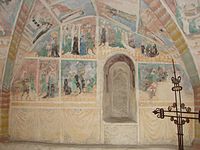
Frescoes in the tower chapel

Tower chapel, vaulted vault


Also worth seeing are the two medieval gates and the town center with some beautifully renovated old half-timbered houses , including the town hall. The old wine press from 1817/18 was converted into a school in 1949/50.

Besigheim Gate
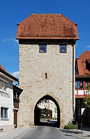
Ottmarsheim Gate
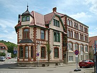
Historic building on Gartenstrasse

Half-timbered house in Hofgasse


Economy and Infrastructure

The historically most important company was the paper mill in Gemmrigheim, which dates back to the 1860s and belonged to the Steinbeis Group from 1971 to 2006 and was closed at the end of 2009. Most of the factory buildings were demolished in the summer of 2013.
A small part of the Neckarwestheim nuclear power plant is located in the Gemmrigheim area. As a result, a small part of the business tax of the operator EnBW also flows into the Gemmrigheim municipal treasury.
In addition to a large number of smaller companies, a number of industrial companies have settled in the industrial area established in the 1960s.

The agriculture still plays a role. In 2007 ten full-time businesses and 25 part-time businesses were counted. Of the approx. 400 hectares of usable agricultural area, more than 60 hectares are vineyards, which is almost eight percent of the municipal area. The preferred grape varieties are Trollinger and Black Riesling . The Gemmrigheimer sites belong to the large Schalkstein site in the Württembergisch Unterland area of the Württemberg wine-growing region .
Public facilities
There is a retirement and nursing home of the district's own shamrock nursing homes .

education
The community has a primary and secondary school with a Werkrealschule . The school center is a remarkable facility that emerged from an architectural competition in the mid-1960s. There are also four kindergartens. In addition to the school center, which was completely overhauled, expanded and refurbished at the end of the 1990s, the site has a community center with a library, a gym, the multi-purpose hall Wasenhalle, and in December 2002 inaugurated a new passive house-style kindergarten in the Neusatz development area .
Supply and disposal
The electricity and gas network in the community is operated by EnBW Regional AG. The drinking water is obtained from the Besigheim water supply group. The waste is taken from the Abfallverwertungsgesellschaft the district Ludwigsburg mbH (AVL), a 100% subsidiary of the district Ludwigsburg. AVL is commissioned to carry out the tasks of avoiding, recycling and disposing of waste on behalf of the Ludwigsburg district.
Sons and daughters of the church
- Carl Reuther (1846–1908), manufacturer and founder of VAG Armaturen
- Eugen Sigrist (1903-1942). executed communist resistance fighter against the Nazi regime
- Rainer Krause (* 1942), psychoanalyst and affect researcher, university professor
- rosalie , b. as Gudrun Müller (1953–2017), stage designer and painter
- Klaus Roth (* 1953), political scientist
- Axel Jüptner (1969–1998), football player
Honorary citizen
- Former Mayor Helmut Klass for more than 30 years of service as Mayor from 1954 to 1986, appointed on June 29, 1990.
literature
- Gemmrigheim community (ed.): Romans, vines and paper. Gemmrigheim in the past and present . 1997.
Individual evidence
- ↑ State Statistical Office Baden-Württemberg - Population by nationality and gender on December 31, 2018 (CSV file) ( help on this ).
- ^ The state of Baden-Württemberg. Official description by district and municipality. Volume III: Stuttgart District, Middle Neckar Regional Association. Kohlhammer, Stuttgart 1978, ISBN 3-17-004758-2 . Pp. 382-384
- ↑ State Statistical Office, area since 1988 according to actual use for Gemmrigheim.
- ↑ http://gemmrigheim.de/,Lde/start/gemmrigheim+im+ueberblick/Geschichte.html History of Gemmrigheim
- ↑ Population development in Baden-Württemberg from 1871 to 2012 ( Memento from September 2, 2014 in the web archive archive.today )
- ↑ http://www.wahlen.kdrs.de/AGS118018/118018g.htm
- ↑ The change in the proportion of votes compared to the previous municipal council election in 2009 is given in percentage points .
- ↑ The change in seats compared to the previous municipal council election in 2009 is given.
- ^ Free voters Stadtverband Gemmrigheim e. V.
- ^ Election result mayoral election in Gemmrigheim. Retrieved on July 26, 2018 (German).
- ↑ LEO-BW - Gemmrigheim
Web links

Affalterbach | Asperg | Benningen am Neckar | Besigheim | Bietigheim-Bissingen | Bönnigheim | Ditzingen | Eberdingen | Erdmannhausen | Erligheim | Freiberg am Neckar | Freudental | Gemmrigheim | Gerlingen | Grossbottwar | Hemmingen | Hessigheim | Ingersheim | Kirchheim am Neckar | Korntal-Münchingen | Kornwestheim | Löchgau | Ludwigsburg | Marbach am Neckar | Markgröningen | Möglingen | Mundelsheim | Murr | Oberriexingen | Oberstenfeld | Pleidelsheim | Remseck am Neckar | Sachsenheim | Schwieberdingen | Sersheim | Steinheim an der Murr | Tamm | Vaihingen an der Enz | Walheim