
Möglingen (Öhringen)
|
Possible
Large district town of Öhringen
Coordinates: 49 ° 14 '46 " N , 9 ° 25' 59" E
|
|
|---|---|
| Height : | 182 (168-290) m |
| Area : | 3.56 km² |
| Residents : | 260 (2012) |
| Population density : | 73 inhabitants / km² |
| Incorporation : | December 31, 1972 |
| Postal code : | 74613 |
| Area code : | 07948 |
 town hall
|
|
Möglingen is a village in Hohenlohe that has belonged to Öhringen ( Baden-Württemberg ) since the end of 1972 . Today the place has 260 inhabitants.
geography
Möglingen is located in the northwest of Öhringen on the right bank of the Kocher . The place extends from the Kocher on an uphill slope about 500 meters to the northwest. Baumerlenbach , with which Möglingen forms a common parish, is located on the opposite, southern bank of the Kocher . A few kilometers to the east lies Ohrnberg , west of Möglingen, and Hardthausen am Kocher .
history
The place was first mentioned in a document in 788 and was then part of the Brettachgau. Around 1400 the place was a Würzburg fief of the Lords of Adelsheim , although Hohenlohe also had rights to the place. In 1454 the lords of Berlichingen acquired the Würzburg fiefdom of the Adelsheimers and in the following years also brought all sovereign rights into their hands. As a result, the place belonged to the knight canton of Odenwald . When the imperial knighthood areas were mediated, Möglingen came to Württemberg in 1803 . Before 1824 the place was raised to an independent mayor's office.
In terms of church, Möglingen has always been a subsidiary of Baumerlenbach , the reformation of the place was carried out by the Lords of Berlichingen. Until the Second World War, the place was almost entirely Protestant, before the influx of displaced people also led a large number of Catholics to Möglingen.
On December 31, 1972 Möglingen was incorporated into Öhringen.
Attractions
- The Evangelical Church was originally a tower choir and still has remains of Romanesque and Gothic architecture. The nave was essentially erected in 1759 instead of a previous structure, as indicated by an inscription on the north portal. After war damage in 1945, the church was restored in 1948/49.
- The former train station and the design of the surrounding square are reminiscent of the Untere Kochertalbahn Bad Friedrichshall - Ohrnberg , which operated via Möglingen from 1913 to 1993 as a private railway of the Württembergische Eisenbahn-Gesellschaft (WEG). In 2008 a cycle path was opened on the route.
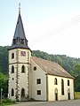
Protestant church

Portal of the Evangelical Church

old trainstation


Personalities
- Kurt Weinmann (1922–2007), chemist and entrepreneur in the chemical industry, born in Möglingen
literature
- City of Öhringen (editor): Öhringen. City and pen. Öhringen, Sigmaringen 1988, pp. 497-506.
- Jürgen Hermann Rauser: Ohrntaler Heimatbuch . XI. Volume: Öhringer book . Weinsberg 1982.
Web links
- Website Öhringen, Stadtteile , Möglingen
- LEO-BW, discover regional studies online , Möglingen
Individual evidence
- ^ Website of the city of Öhringen (accessed on September 29, 2012)
- ↑ Minst, Karl Josef [transl.]: Lorscher Codex (Volume 1), Certificate 13, June 7, 788 - Reg. 1792. In: Heidelberger historical stocks - digital. Heidelberg University Library, p. 69 , accessed on January 19, 2018 .
- ^ Federal Statistical Office (ed.): Historical municipality directory for the Federal Republic of Germany. Name, border and key number changes in municipalities, counties and administrative districts from May 27, 1970 to December 31, 1982 . W. Kohlhammer, Stuttgart / Mainz 1983, ISBN 3-17-003263-1 , p. 455 .
- ↑ Bettina Henke: Where trains once rolled, people now cycle . In: Heilbronner Voice of March 29, 2008 . ( at Stimme.de ).