
Glems (river)
| Glems | ||
 Glemsbrunnen |
||
| Data | ||
| Water code | DE : 23846 | |
| location |
Schönbuch and Glemswald
|
|
| River system | Rhine | |
| Drain over | Enz → Neckar → Rhine | |
| origin | in Glemswald ( Stuttgart ) 48 ° 45 ′ 58 ″ N , 9 ° 5 ′ 52 ″ E |
|
| Source height | 440 m above sea level NHN | |
| muzzle | near Unterriexingen in the Enz coordinates: 48 ° 56 '26 " N , 9 ° 3' 12" E 48 ° 56 '26 " N , 9 ° 3' 12" E |
|
| Mouth height | 188 m above sea level NHN | |
| Height difference | 252 m | |
| Bottom slope | 5.4 ‰ | |
| length | 47 km | |
| Catchment area | 195.5 km² | |
| Outflow at the Talhausen gauge |
NNQ (1991) MNQ MQ |
260 l / s 430 l / s 990 l / s |
 Mouth of the Glems (from left) into the Enz near Unterriexingen |
||
The Glems is a right tributary of the Enz in Baden-Württemberg . It rises in the Rotwildpark nature reserve near Stuttgart , which is part of the Glemswald in the west of Stuttgart . It flows through the districts of Böblingen and Ludwigsburg , divides the Strohgäu and flows into the Enz at Unterriexingen . Its length is 47 km; its catchment area covers 196 km².
Surname
The name could come from ancient times and derived from the Indo-European word * glom (a) / * glem (a) to * Glamis (i) a , which means the name would mean "the muddy one".
geography
course
The headwaters of the Glems are located in the Glemswald, in the southern German Keuperbergland , at an altitude of around 460 m above sea level. NHN . There is a valley formation here and an intermittent water-bearing course. The so-called Glemsbrunnen lies further down the valley towards the south-southeast, namely at the southern end of the Glemswiese clearing at an altitude of around 435 m . Another 300 m further down the valley, the young body of water flows as a small forest stream through the approximately 12 a-large Glemsweiher and then flows into the Pfaffensee - one of Stuttgart's park lakes . This lake was created in 1566 by damming the Glems as a water reservoir, it extends to the west. This is followed by the New Lake below , which continuously releases water into the water through a bottom outlet. When this lake is filled up after persistent rainfall, the New Lake also releases water from the stream via an overflow. After crossing under Magstadter Straße, the Glems re- emerges on the smaller ice lakes . This is also where the Katzenbach flows from the south, which noticeably contributes to the water flow of the Glems on the upper reaches.
The Glems then follows the so-called Mahdental in a westerly direction . After about 500 m it leaves the Stuttgart urban area at the small settlement Glemstal and after a 4 km run changes to the district of Leonberg and thus to the district of Böblingen . South of Leonberg, the comparatively narrow Mahdental valley below the Glemseck castle ruins opens up into a wide plain. After another five kilometers, on which it finally crosses the city of Leonberg in the south between the center of the Leonberg district of Eltingen and the Hertich industrial area, it then flows around the low Schopflochberg (natural monument and bird sanctuary) at an altitude of around 350 m and suddenly changes between the Leonberg districts of Silberberg and Gartenstadt from the west to the northeast. This 130 ° bend is called the Glemsknie. From Höfingen the Glems has dug itself deep and winding into the Upper Muschelkalk, creating steep valley slopes in the process. After entering the Ludwigsburg district, the Glems crosses the Ditzingen , Hemmingen , Korntal-Münchingen , Schwieberdingen and Markgröningen markings , dividing the Strohgäu into a western and an eastern plateau.
In Ditzingen, where the Glems is partially twisted, it changes its direction again and now moves northwards. Despite the shell limestone , the valley is initially quite flat and wide. It is only towards Schwieberdingen, for example from the mountain spur with the ruins of the Nippenburg , that the valley becomes significantly narrower again and partly also bears hillside forest again.
Striking steep slopes can then be found on Markgröninger Markung, where rock faces and steep limestone grasslands are in several places to the right of the Glems. On some sun-exposed slopes, steep-slope viticulture is still practiced, especially on the Mühlberg and Talhäuser Berg. Many of the once numerous vineyards are, however, left to decay. In Won cooling Bronnen between the lower mill and the paper mill and Won watching houses between the group sewage treatment plant and the Talhausen Hohberg the Glems are two left or right deserted villages . The hamlet of Talhausen , which fell desolate in the Thirty Years' War , was repopulated in the 18th century. The remains of lying right above Talhausens Schlüsselburg were eliminated in the 1960s completely. Unterriexingen , which has belonged to Markgröningen since 1973 , once divided the Glems into a Württemberg and a local part.
From Talhausen the Glemstal for large-scale one conservation area Enztal between the Leinfelder yard and Bietigheim-Bissingen and is largely as a FFH area 's security. To the north of Unterriexingen, the Glems finally flows into the Enz at an altitude of 188 m .

Höfingen left over the Glemstal

Nippenburg ruins near Schwieberdingen

Vineyards on the Markgröninger Mühlberg, on the right the Glems

Lower course of the Glems above Talhausen

Mountain spur of the Schluesselburg from the south


.jpg)
.jpg)

Tributaries
![]() Map with all coordinates: OSM | WikiMap
Map with all coordinates: OSM | WikiMap
- Bernhardsbach , from the right after passing through the Bärensee in the Neuer See (see Stuttgart Parkseen ) ⊙ , 3.7 km and 4.0 km²
- Bandtälesbach , from the left to the new lake ⊙ , 5.8 km on the longest flowing stretch Steinbach - Katzenbach - Bandtälesbach and 12.0 km²
- Inflow from the exchange blade , from the right to the Gerlinger Wohnplatz Glemstal ⊙ , 0.9 km
- Inlet from the Spitzklinge , from the right in front of the Leonberger Wohnplatz Mahdental ⊙ , 0.8 km
- Hedersbach , from left to Mahdental ⊙ , 1.3 km
- Krummbach from the Krummbachtal , from the right immediately afterwards and before the residential area Glemseck ⊙ , 3.7 km and 4.3 km²
- Elendbach , from the left at Glemseck ⊙ , 0.8 km
- Rohrbach , from left to Glemseck ⊙ , 2.0 km
- Scharrhaldenbach , from the left at the Leonberg junction of the A 8 ⊙ , 1.7 km
- Mühlgraben , from the right near the Ramtel district of Leonberg ⊙ , 1.4 km
- Mollenbach , from the left across from the Eltingen district of Leonberg ⊙ , with the longest upper course Tiefenbach 2.0 km
- Wasserbach , from the left into the Glemsknie opposite the Schopflochberg near Leonberg ⊙ , 4.5 km with the upper reaches of the Eisengriffgraben and 14.5 km²
- Lohlenbach , from the left at the roundabout of the Gartenstadt residential area in the Leonberger core city ⊙ , 2.3 km and 3.0 km²
- Fockenbach , from the left into the Mühlkanal to the Scheffelmühle ⊙ , 3.3 km and 6.2 km²
- Tilghäuslesgraben , from the right opposite the east end of the Höfingen district of Leonberg ⊙ , 0.7 km
- Lindenbach , on the Unterlauf Lachengraben , from the right in Ditzingen ⊙ , 10.6 km and 28.6 km²
- Raunsgraben , from the left on the northern edge of Ditzingen at the transformer station ⊙ , 3.9 km and 4.3 km²
- Döbach , from the left below-opposite the Glemsmühle from Korntal-Münchingen ⊙ , 5.1 km with the longer right upper course Aischbach and 16.7 km²
- Gaichelgraben , from the left in its Mühlkanal at the Hagmühle von Hemmingen ⊙ , 4.5 km and 6.5 km²
- Wannengraben , from the left near the Schwieberdinger Stumpenmühle ⊙ , 1.9 km and 1.3 km²
- Rauschelbach , from the right in southern Schwieberdingen ⊙ , 4.8 km and 16.1 km². The significantly poorer catchment area on the right upper reaches of the Aischbach is a little longer than the upper reaches of the river
- Klingengraben , from the left from the Eichholzer Klinge at the Raisershaus near Markgröningen ⊙ , 5.1 km with the upper reaches of the Wiesengraben and 8.2 km²
- Wettebrunnen (verdolt), from the right from the blade of the Vaihinger Steige ⊙ , approx. 0.7 km. Spring intake at the Wetteplatz in Markgröningen.
- Kühler Bronnen , from the right from the blade south of the “Sankt Johännser” at Markgröningen ⊙ , approx. 0.7 km. Source on the northwestern edge of the city.
Places on the Glems
Places on the banks of the Glems from the source to the mouth, with communal and district affiliation:
- District-free Stuttgart
- (uninhabited)
-
Ludwigsburg district
- City of Gerlingen
- Glemstal (living space, left)
- City of Gerlingen
-
District of Boeblingen
- City of Leonberg
- Mahdental (living space , right)
- Glemseck (living space)
- Behind Ehrenberg (living space, right slope)
- Ramtel (district, right)
- Eltingen (district)
- Leonberg (central district, right)
- Garden City (district, left)
- Felsensägmühle (living space , right)
- Scheffelmühle (living space, left)
- Höfingen (village, left slope)
- Tilghäuslesmühle (living space , left)
- Glaunhalde (living space , left)
- City of Leonberg
- Ludwigsburg district
- City of Ditzingen
- Tonmühle (living space , left)
- Oberes Glemstal (living space, left)
- Mount of Olives (living space)
- Zechlesmühle (living space , left)
- Ditzingen (central district)
- Maurenerberg (living space , right slope)
- Ferbermühle (living space , left)
- Talmühle (living space, left)
- City of Korntal-Münchingen
- Glemsmühle (settlement area, right)
- Hemmingen municipality
- Sägmühle (living space, left)
- Hagmühle
- City of Ditzingen
- municipality Schwieberdingen
- Schwieberdingen (village, mostly on the right)
- Neumühle (living space, left)
- City of Markgröningen
- Raisershaus (living space , left)
- Obere Mühle (living space, right)
- Markgröningen (central district, right slope)
- Bruckmühle (living space, left)
- Unteres Schafhaus (living space, on the left slope above the Bruckmühle)
- Spitalmühle (living space, right)
- Lower mill (living space, left)
- Paper mill (settlement area, right)
- Talhausen (hamlet, left)
- Unterriexingen (village)
Floods

In the 20th century, severe flooding occurred at regular intervals on the Glems. As in countless other central European rivers, attempts were therefore made in the 1960s to ban these floods by regulating the water. It soon became apparent that the rotations and straightening that had been carried out did not solve the flood problem, but severely impaired the aesthetic and ecological value of the water. In the catchment area of the Glems there is very little forest, but a lot of intensively used, often drained agricultural area. A very large part of the catchment area is also sealed .
On July 4, 2010, a thunderstorm quickly fell between 70 and 100 mm. In Ditzingen, the sewage treatment plant was flooded, presumably with untreated sewage reaching the Glems. In Schwieberdingen alone, where the water stood one and a half meters high on the street, at least 200 households were affected. At the Talhausen gauge , the Glems reached a discharge of around 49 cubic meters per second. A discharge of 42 m³ / s corresponds to a statistically hundred-year flood. There had been similarly strong floods almost to the day exactly one year before, on July 3, 2009.
traffic
Bridges over the Glems
In the Glemstal there have always been virtually no traffic axes, which makes it so valuable for local recreation and nature conservation. The more deeply cut valley is crossed by roads and rails:
- At Schwieberdingen, Bundesstraße 10 crosses the Glems on the Glemstal Viaduct , a 280-meter-long arched bridge.
- A few kilometers further, near Markgröningen, the 348 meter long Glemstalbrücke of the high-speed railway line Mannheim – Stuttgart crosses the Glems.
- In Markgröningen and Unterriexingen there are still historical arch bridges made of shell limestone.

New Glemsbrücke of the Strohgäubahn

Glemstal viaduct of the B10 near Schwieberdingen
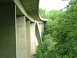
Construction detail of the Glemstal Viaduct

Glemstalbrücke of the Schnellbahn at Markgröningen
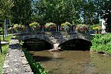
Unterriexinger Glemsbrücke

.jpg)


Strohgäubahn
On its section between Münchingen and Hemmingen, the Strohgäubahn follows the Glems for a while. When planning the route, the naturally given contours in the landscape were followed, thus avoiding complex bridge constructions by leading the route over side valleys from the villages on both sides to the Glemstal valley and connecting it along the valley channel.
history

The middle section of the Glems formed the tribal border between Franconia and Alemanni from 496 to 746 . Around 750 the Franconian caretaker Karlmann had the rulership area of Glemsgau, which largely coincides with the Strohgäu , set up on both sides of the Glems and occupied with a count .
The former Franconian-Alemannic mark still separated the two Catholic dioceses of Speyer and Konstanz until the Reformation , which is why a Speyer and a Konstanz church were once built in Ditzingen on both sides of the Glems. The local churches to the left of the Glems as well as Eltingen, Leonberg and the departed Beisheim were all part of the Grüningen regional chapter of the Speyr “ Archidiakonats Trinitatis ”, which was converted into a Protestant church district under the direction of the Markgröningen superintendent after the Reformation .
The fish-rich section at "Canstatt", a lost hamlet near the upper mill , which Count Eberhard im Bart had transferred to the Grüninger Vogt Conrad Lyher and which the Vogt Philipp Volland later claimed as the son of Elisabeth Lyher, was a point of contention in 1514 as a former commons Poor Konrad .
.jpg)
Glemsmühlen
The glems was lined with numerous mills . In addition to flour mills were temporarily Bark Mill , fulling mills , oil mills , hemp rubbing , Sägmühlen , a hammer mill , a paper mill and a powder mill powered by water. The signposted Glemsmühlen cycle path leads 40 kilometers through the valley. At 19 touched mills, boards provide information about history and the once very important miller's trade.
Attractions
Sights of the places along the Glems and abandoned settlements can be found in the list of places in the Strohgäu .
literature
- Herbert Fauser, Karl-Jürgen Bunnenberg, Karl Feucht (eds.): Hiking guide Heckengäu, Strohgäu, Glemswald. Verlag Theiss, Stuttgart 1999, ISBN 3-8062-0871-9 .
- Stefan Kriz: The Strohgäu - a regional sketch . In: Volume 2 of the series Durch die Stadtbrille - history and stories about Markgröningen. Edited by Working group for historical research and monument preservation in Markgröningen. Markgröningen 1986, pp. 13-22.
- Ulrich Kröner: The Glemstal through the ages. Landscape development and change along the Glems. Diploma thesis at the Geographical Institute of the University of Stuttgart, October 2000.
- Millers, mills, hydropower . Volume 5 of the series Durch die Stadtbrille - history and stories about Markgröningen , ed. v. Working group for historical research and monument preservation in Markgröningen. Markgröningen 1995.
References and comments
- ^ Friedrich Huttenlocher , Hansjörg Dongus : Geographical land survey: The natural spatial units on sheet 170 Stuttgart. Federal Institute for Regional Studies, Bad Godesberg 1949, revised 1967. → Online map (PDF; 4.0 MB)
- ↑ Length according to the water network layer (AWGN) on: Landesanstalt für Umwelt Baden-Württemberg (LUBW) ( information ).
- ↑ Catchment area after the layer aggregated areas 05 ( AWGN ) on: Landesanstalt für Umwelt Baden-Württemberg (LUBW) ( information ).
- ↑ Flood forecast center Baden-Württemberg
- ↑ a b Ulrich Kröner: The Glemstal in the course of time. Landscape development and change along the Glems. Diploma thesis at the Geographical Institute of the University of Stuttgart, October 2000.
- ↑ deserted villages cooling Bronnen and Talhausen on the Aussfeldkarte of 1752 (detail)
- ↑ Deserted peep houses on the Urflurkarte from 1830 (excerpt)
- ↑ 1832 still with an open source catchment at the Wette in the original town center ( ⊙ ), open course from the Upper Sheep House and additionally fed from the city moat and the pond on Schäferweg. See Urflurkarte (1832) .
- ↑ Flood on the Glems , 2016 by lahrensmuehle.de
- ↑ Thunderstorm: streets flooded , July 4, 2010, Stuttgarter Nachrichten (StN)
- ↑ Talhausen / Glems gauge: Hydrological parameters
- ↑ Torrential rains flood streets, gardens and cellars - fire brigade and THW on a large scale , Sunday, July 4th, 2010, NonstopNews
- ↑ See map of the Landkapitels Grüningen around 1500 and map of the Protestant church district after 1736
- ^ Hermann Römer : Markgröningen in the context of regional history I. Prehistory and the Middle Ages. Markgröningen 1933, pp. 190ff and 285
Web links
- Map of the course and catchment area of the Glems on: State Institute for the Environment Baden-Württemberg (LUBW) ( information )
- Water report 2003, published by the City of Stuttgart, Office for Environmental Protection (PDF file (2.5 MB), Chapter 4.2.7: The Glems)
- Level data for the Glems near Talhausen
- Flood on the Glems