Raunsgraben
| Raunsgraben | ||
|
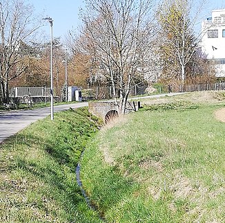
The Raunsgraben east of Hirschlanden |
||
| Data | ||
| Water code | DE : 2384672 | |
| location |
Neckar and Tauber-Gäuplatten
|
|
| River system | Rhine | |
| Drain over | Glems → Enz → Neckar → Rhine → North Sea | |
| source | southwest of Ditzingen - Hirschlanden 48 ° 49 ′ 58 ″ N , 9 ° 0 ′ 52 ″ E |
|
| Source height | approx. 370 m above sea level NHN | |
| muzzle | on the northern edge of Ditzingen in the Glems coordinates: 48 ° 50 '2 " N , 9 ° 3' 50" E 48 ° 50 '2 " N , 9 ° 3' 50" E |
|
| Mouth height | approx. 290 m above sea level NHN | |
| Height difference | approx. 80 m | |
| Bottom slope | approx. 21 ‰ | |
| length | 3.9 km | |
| Catchment area | 4.263 km² | |
The Raunsgraben is an almost 4 km long left tributary of the Glems on the mark of the city of Ditzingen .
course
The Raunsgraben has its origins in a pond west of the Hirschlanden district of the city of Ditzingen, crosses under the state roads L 1136 and L 1177 and runs almost straight in an easterly direction along the southern outskirts of Hirschlanden and through the industrial area "Lange Äcker" over the Ditzinger Feldmark , before it flows into the Glems at the substation on the northern outskirts of Ditzingen. The course in and near Hirschlanden is twisted .
nature
To the west of the spring pool is the 0.26 ares large biotope field wood with pond at the Aussiedlerhof Holzheim with field wood and reed bed . On plants grows there u. a. the common hazel , the common Pfaffenkäppchen , the common ash , the bird cherry , the dog rose , the black elder and the woolly snowball .
Remarks
- ↑ a b topographic map
- ↑ Length according to the water network layer (AWGN) of the LUBW's online map server .
- ↑ Catchment area after the layer aggregated areas 05 ( AWGN ) of the online map server of the LUBW .
- ↑ Field trees with a pond at the Aussiedlerhof Holzheim
