Talhausen
|
Talhausen
City of Markgröningen
Coordinates: 48 ° 54 '57 " N , 9 ° 3' 49" E
|
|
|---|---|
| Height : | 260 m above sea level NN |
| Residents : | 100 (2010) |
| Postal code : | 71706 |
| Area code : | 07145 |
|
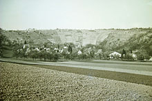
Talhausen seen from the Schluesselberg
|
|
Talhausen an der Glems is a district of Markgröningen in Baden-Württemberg . The hamlet below the former Schlüsselburg fell in desolation during the Thirty Years' War and was repopulated from 1770.
geography

The hamlet of Talhausen, which has around 100 inhabitants, is located on a loess- covered sliding slope to the left of the Glems , whose valley, cut deep into the shell limestone , divides the Strohgäu and borders the Lange Feld in the west. The location is around two kilometers northwest of Markgröningen and just under three kilometers south of the Unterriexingen district , to which, however, only a largely unpaved dirt road leads. Because the idyllic Glems section between Talhausen and Unterriexingen is under special protection according to the Fauna-Flora-Habitat-EU Directive . The heather on the steep slope of the opposite Schlüsselberg is kept open through sheep grazing as part of nature conservation. Various rare plants can be found on this poor, dry site, including light-loving orchids and silver thistles.
Only a few of the once numerous steep-slope vineyards on the Sonnenberg, the Schlüsselberg and the Talhäuser Berg are still cultivated. Most were left to their own devices and are now forested. Some are partly used as a weekend property.
history
Dark Middle Ages
When and by whom the hamlet of Talhausen was founded is in the dark. In 1304 he was first mentioned in a document as "Dalhusen" in the land register of the Katharinenspital in Esslingen. In 1340 vineyards were listed that the Grüninger pleban Conradus owned "in villa Talenhusen".
The place name Talhausen allows conclusions to be drawn about a foundation in the High Middle Ages and a relationship to houses above the valley. In any case, the so-called Sankt-Johanns-Kapelle, which could have been surrounded by a small settlement in the Middle Ages, was located south of the castle stables of the former Schlüsselburg and a little lower. As a former commons, their potential settlement area is still owned by the city today. Several ravine relics leading from here to Talhausen suggest that this (from Markgröning's point of view) front counterpart to the Hinteren Steige (north of the castle) was once busy with traffic. It is therefore reasonable to assume that a heavily frequented road from Markgröningen used to lead past the Schluesselburg and through Talhausen on towards Burg Dauseck and Enzweihingen or down the Glems to Unterriexingen . Perhaps temporarily also the trunk road that was diverted via Grüningen around 1500 and is now called "B10".
Before Unterriexingen, to the right of the Glems, there was once a small settlement called the peep houses . When will they existed and when they came off , is not known.
Founding of the Schlüsselbergers?
In 1322, the noble free Konrad II von Schlüsselberg was enfeoffed by King Ludwig the Bavarian with the Reichssturmfahnlehen including the castle and town of Grüningen for his military services . Because of his name Konrad von Schlüsselbergstraße is often the preferred above Talhausens and with the 1380 mentioned "exterior castle" Grüningens equated Schlüsselburg attributed. Why the wealthy Schlüsselberger, who lives in Franconian Switzerland, should have built or acquired an additional castle near Grüningen without a male heir, however, does not seem to be clear. Especially since he gave the Grüninger fiefdom back to Count Ulrich III under pressure from Emperor Ludwig of Bavaria in 1336 . von Württemberg resigned and apparently invested the sales proceeds in his town of Schlüsselfeld, founded in 1336 (in the Bamberg district ).
A castle of the knights of Rietpur?
More probable is the thesis that the castle was built much earlier and belonged to a noble knight family. Possibly it was the Rietpurer (also called by Rieppurg or Rüppurg ), which can be proven several times in the area . Because in 1399 Anna von Klingenberg sold the 30 acre area of the then still independent town of Talhausen, which was formerly part of Rietpur (i.e. belonged) and which the Counts of Württemberg did not yet own, to Count Eberhard the Milden . The noble families of Rietpur (g) and those of Klingenberg are said to have originally been from Weißburg, then Eberstein and Baden ministerials . Since Count Hartmann III. von Grüningen was married to a daughter of the noble Count family von Eberstein , the Rietpur came into the Markgröningen environment through this connection. Or about the gentlemen von Roßwag , possibly related to the Ebersteiners , with whom they shared the Baden village of Spessart .
In files of the Grüningen office from 1424, Talhausen is listed as an independent place alongside Schwieberdingen and Tamm .
Departure in the Thirty Years War
When the stubborn Grüninger citizens had to personally swear eternal loyalty to their Wuerttemberg sovereign in 1396, "those of Dalnhusen" were also listed in their "Urfehde-Brief", who were already subjects of Wuerttemberg: The first of the Cuntzlers, Ruff Strowelin, the Güß, Haintz Strölin, Hainrich Blaufus, Kunzlins Do [c] hterman, Der Holzappel, Haintz Schauf, Cuntzlin Rudger and Haintz Vogel. Ten heads of household suggest around 70 Württemberg residents, whose community was apparently administered from Grüningen . Nothing is known about the number of Klingenberg subjects. From an interest rate register from 1424 it can be seen that the hamlet, which had been completely Württemberg since 1399 , had a mayor , although only seven citizens had to pay taxes for six houses. The Sankt-Johanns-Kapelle near the Schluesselburg was still occupied by a chaplain.

In 1665 Talhausen no longer appears in the land register. It is therefore assumed that Talhausen was ravaged by marauding soldiers during the Thirty Years' War and fell desolately . Residents fleeing behind the walls of Markgröningen found no permanent protection here either, because the city on its own had nothing to oppose the imperial troops. Due to their attacks, famine and plague, the city lost a large part of its inhabitants.

Second settlement phase
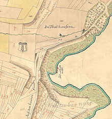
In the "Aussfeldkarte" from 1752, which was taken to recultivate the mostly neglected parts of the land west of the Glems, Talhausen is still listed as a desert . From 1770 Talhausen and Aichholzhof were resettled and the Schönbühlhof was founded . In 1831, the Royal Württemberg Court and State Manual counted 32 residents in Talhausen. At that time the hamlet consisted of only five farms on the mountain path. The route structure on the Urflurkarte from 1832 testifies to what was once a greater expansion along the Glems. The connection to Markgröningen via the front path still runs in a ravine, of which relics have been preserved in the heather south of the Schluesselburg.
In the description of the Oberamt Ludwigsburg from 1859, the “hamlet of Thalhausen” located “half an hour northwest of Markgröningen on a moderately sloping foothill on the left slopes of the valley against the Glems” is briefly described: “The not unfriendly place hidden behind fruit trees receives its drinking water from two never-ending pump wells. The generally hard-working, incidentally only moderately well-off residents deal exclusively with agriculture, which is somewhat difficult to operate as most of the goods are located on the hill and in some cases quite far away from the village. ”However, this did not take into account that currently in Talhausen a water-powered hammer forge and five minutes upstream a paper mill , previously a powder mill , operated.
Contemporary history
In April 1945 the Leudelsbach bridges on the Tammer and Asperger Straße and all Glemsbrücken on the way to Talhausen were blown up at the behest of the Nazis. On the heights to the right of the Glems the Volkssturm was supposed to take up position to stop the approaching French troops. On April 21, 1945, however, the French marched unhindered into Markgröningen and withdrew on July 14, 1945 to leave the field to the Americans.
Forced laborers who had not yet returned home from Poland and Russia undertook raids in the vicinity of Markgröningen, for example in Talhausen and the Spitalmühle , on the Aichholzhof and in Haus Frank. On the night of November 10th, they attacked the hospital mill, drove the residents to be found into the cellar and shot them to the head.
The Spitalmühle, which was destroyed in the Thirty Years' War and rebuilt in 1680, has been in the same family since 1817. It is the only mill in Markgröningen that survived in its original form as a grain mill into the 21st century.
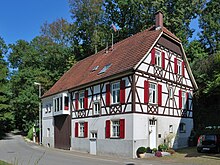
In 1840, master blacksmith David Heller built a water-powered hammer forge in Talhausen. It was located on an 80 meter long canal branched off to the right of the Glems and was first propelled by one, later by two undershot water wheels. Around 1880 Johann Keuerleber set up a machine and tool factory here. It had a five-meter-high and 1.21-meter-wide, medium-sized cellular wheel, which was replaced by a Francis turbine in 1908. At the beginning of industrialization, the factory produced drilling machines, then also cart spindles for handcarts and metal loops for telegraph poles. The products were transported to the Markgröningen train station by handcart. In 1958 the production facility was given up and the company moved to Markgröningen. The Mühlkanal was later filled in and the weir was removed.
In 1969 the paper mill above Talhausen , which had been in existence since 1788 and burnt down twice, was closed, in 1971 the Mühlkanal was filled and the factory building demolished. Two houses have been preserved.
In 1980 the waste water treatment association group sewage treatment plant Talhausen built the sewage treatment plant below Talhausen. The municipalities of Schwieberdingen , Hochdorf an der Enz (Eberdingen), Hemmingen , Korntal-Münchingen (for Münchingen) and Markgröningen belong to this association . The financing was divided according to the residents connected in each case.
The Weilerfest Talhausen was carried out in the 1980s by a number of dedicated valley houses. On February 11, 2001, there was a fire in the house on Bergweg 17. In 2007 the fire station, which had been out of service since the late 1970s, was torn down.
Flood
On July 4, 2010, a thunderstorm quickly fell between 70 and 100 mm. In Ditzingen, the sewage treatment plant was flooded, with untreated sewage entering the Glems. In Schwieberdingen, where the water stood one and a half meters high on the street, at least 200 households were damaged. In Talhausen the tide increased dramatically: At the Talhausen gauge, the Glems reached a discharge of around 49 cubic meters per second. A discharge of 42 m³ / s corresponds to a statistically hundred-year flood. There had been similar floods almost to the day before, on July 3, 2009. The damaged Talhausen sewage treatment plant was then provided with flood protection structures.
literature
- Heyd, Ludwig Friedrich : History of the former Oberamts-Stadt Markgröningen with special consideration for the general history of Württemberg . Stuttgart, at FC Löflund und Sohn, 1829. Facsimile edition for the Heyd anniversary 1992, ed. v. Working group on historical research, heritage and monument preservation in Markgröningen.
- Markgröningen - people and their city. Comprehensive presentation of the city's recent history in approx. 60 individual articles . Volume 6 of the series "Durch die Stadtbrille", ed. v. Working group on historical research, heritage and monument preservation in Markgröningen. Markgröningen 2000
- Miller, Max et al. Gerhard Taddey : Baden-Württemberg. Handbook of the historical sites of Germany. Vol. 6. Stuttgart 1965, 1980
- Millers, mills, hydropower . Volume 5 of the series "Durch die Stadtbrille", ed. v. Working group on historical research, heritage and monument preservation in Markgröningen. Markgröningen 1995
- Römer, Hermann : Markgröningen in the context of regional history I. Prehistory and the Middle Ages. Markgröningen 1933
- Schulz, Thomas: Mill Atlas Baden-Württemberg, Vol. 3: The mills in the Ludwigsburg district . Remshalden-Buoch 1999
Remarks
- ↑ Source: LABW, Main State Archives Stuttgart, A 602, WR 8786, LABW online .
- ^ The Ministerial Rudolf Kamrer and his wife Anna von Klingenberg left on September 5, 1399 Count Eberhard III. their wine and grain tithes at Tamm and their share at Talhausen in exchange for a personal thing. Source: LABW, HStA Stuttgart, A 602, No. 8746 = WR 8746 LABW online .
- ↑ Source: LABW, HStA Stgt., H 101/38 Secular Stock Books, Volume 1: OA Markgröningen / 1424-1817 LABW online .
- ^ Ludwig Friedrich Heyd : History of the former Oberamts-Stadt Markgröningen with special regard to the general history of Württemberg , Stuttgart 1829, p. 33ff.
- ↑ In 1751 the neglected "Aussfeld" west of the Glems was measured for recultivation and recorded in the Aussfeld map from 1752. See outfield map .
- ↑ See outfield map from 1752
- ↑ Source: Royal Wuerttemberg Court and State Manual ( Memento of the original from November 11, 2013 in the Internet Archive ) Info: The archive link was automatically inserted and not yet checked. Please check the original and archive link according to the instructions and then remove this notice.
- ↑ Source: Urflurkarte, map sheet NO XXXIX.1, as of 1832, digitized LABW online .
- ^ Karl Eduard Paulus : Description of the Oberamt Ludwigsburg . Ed .: Königlich Statistisch-Topographisches Bureau. Stuttgart 1859. Reprint: Bissinger, Magstadt, 1975, ISBN 3-7644-0038-2 , Wikisource .
- ^ Haus Frank: country house on Unterriexinger Strasse on the outskirts of Markgröningen.
- ↑ Hilde Fendrich: The Americans are coming . In: Markgröningen - People and their City , Volume 6 of the series “Through the City Glasses”, ed. v. Working group on historical research, heritage and monument preservation in Markgröningen. Markgröningen 2000, p. 355ff.


