
Dauseck Castle
| Dauseck Castle | |
|---|---|
![Relics of Dauseck Castle and the Old Vaihinger Weg on the Urflurkarte from 1832 [1]](https://de.wikipedia.org/wiki/Datei:Dauseck_UFK_1832_Ausschnitt_markiert.jpg) Relics of Dauseck Castle and the Old Vaihinger Weg on the Urflurkarte from 1832 |
|
| Alternative name (s): | Tuseck Castle |
| Creation time : | 12./13. Century |
| Castle type : | Hilltop castle |
| Conservation status: | Burgstall |
| Standing position : | Ministeriale |
| Place: | Markgröningen - Unterriexingen |
| Geographical location | 48 ° 54 '55.9 " N , 9 ° 0' 54.4" E |
| Height: | 265 m above sea level NN |


The castle Dauseck even castle Tuseck called, is an Outbound hilltop castle on 265 m above sea level. NN over the Enztal . It was temporarily occupied by feudal people from the Counts of Vaihingen . Your castle stable is located southwest of Oberriexingen at the western end of the Unterriexingen mark , which today belongs to Markgröningen in the Ludwigsburg district of Baden-Württemberg .
Search for clues
Lords of the castle
Dauseck Castle was strategically placed on a mountain spur between the Enz Valley in the north and the "Alten Vaihinger Weg" in a blade southwest of the castle, which led on direct routes from the imperial city of Grüningen to Vaihingen an der Enz . The heavily frequented trunk road from Ulm to Speyer ran a little further to the southwest . It was named after the "Lords of Tuseck", who are said to have served as ministerials for the Counts of Württemberg and the Counts of Vaihingen . Count Konrad von Vaihingen is said to have taken the castle from Count Eberhard I of Württemberg in 1311 .
Little is known about the eponymous ministerial family of those von Tuseck . An indirect mention can be found in the description of the Oberamts Brackenheim : “In 1341 the nobleman Heinrich von Hausen, daughter of Siegfried von Tuseck , and his wife Elisabethe Gülten sold on the tithe here, which belonged to the nobleman Gunpolt von Tischingen , to Heinrich Brusse [ n] von Brackenheim. ”The Tusecks' successors as lords of the castle on the Dauseck could have been the Lords of Riexingen , their predecessors the Lords of Pulverdingen, whose ancestral seat is not yet known, but was placed here by Georg Gadner in 1590.
Location and Burgweiler
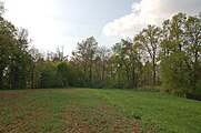
According to the local dictionary, the relics of the castle, which was demolished in 1570, were completely removed in 1789 when a vineyard was created. In fact, the forest map from 1682 (see excerpt) still shows the remains of a building. And on the Urflurkarte created between 1830 and 1832 (see excerpt above), traces and several stone piles of collapsed castle walls can still be seen. The size of the castle stable can also be seen on it.
The structure of the field also suggests a neighboring castle hamlet, which could have existed in 1590. Because here the already quite reliable cartographer Georg Gadner located the village " Bulvertingen " on his Leonberg forest map . After a deserted village , it would therefore be in his founding of the North to the south side of Lower powder Dinger wood been displaced. The settlement area of the castle and hamlet and at least parts of the associated markings fell to Unterriexingen after the desolation, which was presumably carried out during the Thirty Years War and was recorded on the forest map of 1682, and finally to Markgröningen in 1973 through incorporation.
An indication of the castle or a hamlet called Dauseck found in the files of the Oberamts Vaihingen: "Friedrich von Dürrmenz sold [on October 27, 1425] to Henry Meyer, citizens Oberriexingen, each 11 Zimri and an island rye and Haber Valid from Fields near Tuseck in Enzweihinger Mark for 11 fl . "In addition to the forest map from 1682 and the Urflurkarte from 1832, this location provides further evidence that the castle location is further west than the one often assumed on the Oberriexinger marker (coordinates of the wrong location: ⊙ ) .
It is difficult to confirm the clearly cartographically clear findings in the undergrowth of the actual castle stables, because no obvious remains of walls or moats are visible. The neck ditch , at least to be expected on the eastern flank, was apparently filled. On the south and west exposed slopes around the castle stables, however, there are still a number of rubble fans and isolated hewn stones; south of the castle stables there is also a well-preserved boundary stone with the old signets of Enzweihingen and Unterriexingen (see illustration below). Ultimate certainty about the structure and character of the castle could only be provided by an archaeological investigation.
It is possible that a manor house or another building was once placed at the wrong Dauseck location, now called “Schlossberg”, which was named “Ob der Hilder” in the Urflurkarte and was outside of the “Im Dauseck” area. However, the Baden-Württemberg State Monuments Office can rule out the foundations of a castle after a geophysicist carried out soil soundings in June 2014 and found no evidence of a castle during their evaluation. The geophysicist confirmed, however, that he could not use the necessary measuring devices (magnetometers) because there was electricity in the area of the Schlossberg and high levels of metal in the buildings that would interfere with the devices. A clear answer is therefore not possible.
Recent changes
During the Nazi era, two bunkers in the Neckar-Enz position were built in the south-west and north-west exposed slopes of the Bergsporn below the castle stables , which were blown up after the Second World War , but are still accessible (see illustration).
Where the “Alte Vaihinger Weg” from Grüningen to Vaihingen an der Enz used to run in the “Klinge” not far south of the castle , today the ICEs plunge into the Pulverdinger Tunnel on the Mannheim – Stuttgart high-speed line . The area south and west of the castle stables was partly filled with tunnel debris and re-modeled in the course of the railway construction.
Burgstall from the east at the end of the Unterriexinger mark

Slope around the Burgstall from the railway overpass in the west
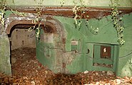
Bunker of the Neckar-Enz position on the slope below the castle stable


Eponymous
The "Theater Unter der Dauseck Oberriexingen Association", founded in 1993, was named after the castle. It emerged from the amateur drama group that had staged the play “So a Metzelsupp” in 1992 for the 1200th anniversary of Oberriexingen and has since brought several other plays to the stage.
In addition, the natural monument 25/49 “Dauseck plant site” was named after the former castle.
Remarks


- ↑ bold black line: Unterriexinger marking limit; blue line: old Vaihinger way. Source: Leo-BW online
- ↑ North-north section from the south-facing forest map 158 (Enzweihingen) by Andreas Kieser (1682) Leo-BW online
- ↑ See local lexicon Baden-Württemberg ( memento of the original from March 4, 2016 in the Internet Archive ) Info: The archive link was inserted automatically and has not yet been checked. Please check the original and archive link according to the instructions and then remove this notice. and Dieter Buck: The big book from Stromberg-Heuchelberg. Nature, culture, history, places . 1st edition. Silberburg-Verlag, Tübingen 2006, ISBN 3-87407-704-7 , p. 39 .
- ↑ See Karl Eduard Paulus : Description of the Oberamt Brackenheim. Edited by the Royal Statistical-Topographical Bureau. Stuttgart. 1873 - Wikisource . Source: Certificate in the HStA Stgt., A 602 No. 7414
- ↑ See location of “Bulvertingen” on the Gadner forest map of the Leonberger Forest from 1590 Landesarchiv BW, HStA Stgt., N 3 No. 1/7
- ↑ See local lexicon Baden-Württemberg ( memento of the original from March 4, 2016 in the Internet Archive ) Info: The archive link was inserted automatically and has not yet been checked. Please check the original and archive link according to the instructions and then remove this notice.
- ↑ See forest map 158 (Enzweihingen) by Andreas Kieser (1682) Leo-BW online and section to the north.
- ↑ See current location map including wrong location location of the Burgstall (OpenstreetMap)
- ↑ Source: HStA Stgt., A 602 No. 14268 - Landesarchiv BW online
- ↑ The wrong location on Oberriexinger "Schlossberg" is privately owned and cannot be visited.
- ↑ For data collection on site: Vaihinger Kreiszeitung from June 12, 2014 VKZ online
- ↑ Blade: South German name for a narrow cut in the terrain.
- ↑ See natural monument 25/49 "Dauseck plant location"
Web links
- Local lexicon of Baden-Württemberg
- Section from OAB Brackenheim in Wikisource
- Theater Unter der Dauseck Oberriexingen Association

Aldingen Castle | Altroßwag castle ruins | Altsachsenheim Castle | Old Beihingen Castle | Beihingen New Castle | Lower Besigheim Castle | Upper Besigheim Castle | Bietigheim Castle | Bönnigheim Castle | Ditzingen Castle | Favorite Castle | Freudental Castle | Geisingen Lower Castle | Lower Old Castle Geisingen | Upper Geisingen Castle | Großbottwar Castle | Großsachsenheim Palace | Grüningen Palace | Harteneck Castle | Hemmingen Castle | Heutingsheim Castle | Hochberg Castle | Hochdorf Castle (Eberdingen) | Hochdorf Castle (Remseck) | Hohenasperg fortress | Hoheneck Castle | Hohenstein Castle | Holderburg | Höpfigheim Castle | Kaltenstein Castle | Kleiningersheim Palace | Lichtenberg Castle | Ludwigsburg residential palace | Marbach Castle | Münchingen Castle | Monrepos lake castle | Nippenburg | Nussdorf Castle | Oßweil Castle | Remseck Castle | Riet Castle | Schaubeck Castle | Schöckingen Castle | Stadionsches Schloss | Stone house (Bönnigheim) | Unterriexingen Castle
Left: Burg Bietigheim | Bydgoszcz Castle | Dauseck Castle | Eselsberg Castle | Gründelbach Castle | Reichsburg Grüningen | Hohenscheid Castle | Shlisselburg | Steinheim Castle (Murr) | Neurosswag Castle | Remminger Schlössle | Richtenberg Castle | Rotenberg Castle Stable | Schwieberdingen moated castle | Vehingen Castle | Wunnenstein Castle