
Strohgäu


The Strohgäu (of Gaeu or from MHG göu for an area - and straw of cereals) is for Neckarbecken counting Gäulandschaft in Baden-Württemberg , which is also the lower Gaeu is called and the core zone is approximately the former Glemsgau corresponds.
geography
Location and demarcation
According to the division of the handbook of the natural spatial structure of Germany , the Strohgäu belongs to the main natural spatial unit of the Neckar and Tauber-Gäuplatten and is part of the Neckar basin , a loess-covered plateau in the center of the Württemberg lowlands, which is cut by river valleys . It is largely located in the Ludwigsburg district and touches the Stuttgart district near Mühlhausen , Zazenhausen , Zuffenhausen , Stammheim and Weilimdorf as well as the Böblingen district near Leonberg (Höfingen, Gebersheim and Eltingen) and Rutesheim . According to tradition, the Strohgäu is roughly bounded in the east by the Neckar valley and in the south by the Keuperhöhen around Stuttgart and Leonberg. In the west it borders on the Heckengäu, which starts from the Strudelbachtal , and in the north on the Enztal . Of the Strudelbach communities Eberdingen and Enzweihingen , only the former markings of Hochdorf an der Enz and Pulverdingen or the Leinfelder Hof in the east are included.
In the north-east and south-west, the boundaries of the traditional “cultural area” of Strohgäu are not clearly defined. Although there is no natural limit to the areas of Bietigheim to the right of the Enz and to the markings of Freiberg am Neckar , Ingersheim and Benningen am Neckar , these loess plains are usually not included and Ludwigsburg often only includes the former markings of Eglosheim and Pflugfelden - below Exclusion of the Hoheneck and Oßweil markings as well as Neckargröningen and Aldingen . In the south-west Höfingen and Gebersheim are undisputedly added, in the Leonberger core city, Eltingen and especially in Rutesheim again the opinions are divided (see map).
From a physical-geographical point of view, however, these and other places in the north all belong to the Strohgäu. The following natural spatial units of the Neckar Basin (No. 123) form its core zone:
- 123.13 Glems-Strudelbach plate
- 123.14 Long field
- 123.15 Southern edge of the Strohgäu
The northern edge zone includes:
- 123.16 Lower Enztal (only east of Strudelbach, see above)
- 123.17 Metter plate
- 123.18 Southern Stromberg foreland (controversial, is usually counted as part of the Stromberg )
Together with that part of the Heckengäus (north of the A 8 ), which the Handbook of the Natural Spatial Structure of Germany does not count among the Upper Gauens (or Black Forest edge plates - 150) ( cf.Heckengäu # Natural Systematics ), the Strohgäu thus forms the unit 123.1 Southwestern Neckar Basin.
Green Strohgäu
In February 1999, the municipalities of Asperg, Ditzingen, Gerlingen, Hemmingen, Korntal-Münchingen, Leonberg, Markgröningen, Möglingen, Schwieberdingen and the district of Ludwigsburg joined forces to form the “Grünes Strohgäu” working group, which is in dialogue with the Heilbronn-Ludwigsburg farmers' association for matters wants to use nature conservation, direct marketing and local recreation. The municipality of Eberdingen joined in October 2001.
So far, the 40 km long “ Glemsmühlenweg ” and the 30 km long “Keltenweg” have been established. With must awards, the must should be brought back on everyone's lips, direct marketing encouraged and demonstrated "how important orchards are for many animal and plant species". An amphibious tunnel was built near Hemmingen. Recently nothing more has been heard from the working group.
Geology and climate
From a geological, climatic and geomorphological point of view, the border areas shown lighter on the map should also be added as well as the loess areas on Lettenkeuper and Muschelkalk between Enztal and Stromberg , which merge to the north near Erligheim into Zabergäu . From a natural spatial point of view, this peripheral area includes the Nussdorf loess plate, the southern parts of the Vaihinger and Sersheim markings, of Sachsenheim only the former markings of Groß- and Kleinsachsenheim as well as Metterzimmer , Löchgau and parts of Besigheim .
The Strohgäus plateau lies at an average height of around 300 m and is largely covered by loess , which led to the formation of high -yielding black and parabrown soils . The loess layers are particularly thick on the Lange Feld and decrease towards the edge zones. Where there is Lettenkeuper underneath, the smaller rivers such as the Leudelsbach form valley basins; where the shell limestone is found, Strudelbach, Glems, Enz and Neckar have formed steep and winding valleys. As disturbers acts of the 356 meter high Hohenasperg , one by inverted relief arising witnesses mountain of surrounding Keuper Uplands .
The Strohgäu is climatically characterized by long hours of sunshine , high average temperatures and low rainfall . The drainage takes place via Strudelbach , Glems , Leudelsbach , Metter , Enz and Neckar . The Glems runs through the Strohgäu from south to north and divides it into a western and eastern area. The plain between the Glems and Neckar valleys, which is not cut by valleys, is also known as the long field . Together with Hecken-, Korn- and Zabergäu, it forms the Baden-Württemberg Gäu .

.jpg)
Old settlement country
Because of its very fertile loess soils and its favorable climate, the Lange Feld was used for arable farming as early as the Neolithic Age , almost completely cleared and called paradise on earth in the Middle Ages . The sun-exposed, steep valley slopes of Glems, Leudelsbach, Enz, Metter and Neckar, like the southern slope of Asperg, were cultivated for viticulture early on.
Until after the Alemannic conquest, scattered settlements prevailed for local cultivation. Due to political factors and epidemics, the settlement was subject to a progressive concentration process from the High Middle Ages, which resulted in numerous devastation .
From the early Middle Ages to the 18th century, the central location was the former imperial city and Württemberg official city of Grüningen (today Markgröningen ), whose administrative district at times largely coincided with the core area of the Strohgäu and the historical rulership of the Glemsgau and whose church district was first the western and then the eastern half covered. That is why the double-towered Bartholomew's Church in Grüningen was also called the “Strohgäu Cathedral” as the spiritual center in the Speyr rural chapter of Grüningen .
See also: List of places in the Strohgäu with districts and abandoned settlements
traffic
.jpg)
Trunk roads
The Strohgäu has always had good transport links. Here three important highways crossed, which had existed for long stretches since Roman times:
- Today's Bundesstraße 10 led from Flanders to the Black Sea and branched off to Italy near Augsburg, gained great importance as a trade route in the late Middle Ages and was one of the first postal routes in the 16th century.
- Today's federal road 27 ran as a south-north connection from Switzerland to Heilbronn and beyond.
- The third historic trunk road ran in the Remstal along the Limes and then led from Waiblingen via Markgröningen to Strasbourg .
More recently, today's federal highway 295 came from Calw via Leonberg to Stuttgart and, in the Third Reich , the two motorways A 8 and A 81 were added.
Railway lines

The Stuttgart-Ludwigsburg connection was established in the 19th century as one of the first railway lines in Württemberg . Later the construction of the Western Railway from Bietigheim to Mühlacker , the Black Forest Railway from Stuttgart via Ditzingen and Leonberg to Calw and the Schuster Railway from Kornwestheim to Cannstatt took place . In Kornwestheim, a major freight and marshalling yard with a container terminal and a loading station for car train traffic, which has now been closed, was built .
The Strohgäubahn , a single-track, standard-gauge private branch line , has been running from Korntal to Weissach since 1906 . It has a length of 22.3 km. In the course book is the route 790.7, the Transport and Tariff Association Stuttgart (VVS) regional train R61. The Frankenbahn ( Stuttgart - Würzburg ) and the S5 S-Bahn (Stuttgart- Bietigheim ) run partly on the same route. The Black Forest Railway (Württemberg) runs in the south .
The Ludwigsburg – Markgröningen railway has opened up the former capital of the Strohgäus since 1916 and was closed in 1975 for passenger traffic . Until 2003 there was still freight traffic and special trips on this route once a year for the Schäferlauf . Originally it was supposed to be linked to the " Vaihinger Stadtbahn " leading from Kleinglattbach via Vaihingen / Stadt to Enzweihingen . This branch line operated by the WEG was also closed in 2002.
The 9.3 km long Feuerbach municipal tram (SSF) was a regional tram in Württemberg that ran from Feuerbach via Weilimdorf to Gerlingen from 1926 to 1933 . After the takeover by the Stuttgart trams (SSB) on January 1, 1934, the line was integrated into their network. Today, the underground lines U6, U13 and U16 largely follow the former SSF route.
Today the new Mannheim – Stuttgart line cuts through the Strohgäu or Lange Feld. Some trains stop at Vaihingen (Enz) station, which was completed in 1991 . The places between Vaihingen and Bietigheim-Bissingen are connected to the Stadtbahn network of the Karlsruher Verkehrsverbund (KVV).
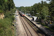
S-Bahn stop Höfingen
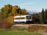
Strohgäubahn near Korntal

Disused train station in Markgröningen

ICE 3 at the Pulverdinger tunnel


In local public transport , the Strohgäu is connected to the Stuttgart Transport and Tariff Association (VVS) and to the Pforzheim-Enzkreis (VPE) transport association:
- U 6 Fasanenhof-Stuttgart-Feuerbach-Gerlingen
- U 16 Fellbach-Bad Cannstatt-Feuerbach-Giebel
- S 4 Stuttgart – Ludwigsburg-Freiberg- Marbach am Neckar - Backnang
- S 5 Stuttgart-Ludwigsburg- Bietigheim
- S 6 Stuttgart– Leonberg - Because of the city
- S 60 Stuttgart– Renningen - Böblingen
- R61 Korntal –Münchingen – Schwieberdingen – Hemmingen – Heimerdingen– Weissach ( Strohgäubahn )
- IC61 Nuremberg –Stuttgart- Karlsruhe with a stop in Vaihingen an der Enz


Economy and settlement
Because of its fertile soils ( parabroun earths from loess ) and the mild climate, the Strohgäu is known for its high-yielding agriculture , in particular for growing grain and sugar beet . Nevertheless, the number of farms has decreased dramatically over the past fifty years. On the one hand due to the structural change in agriculture, on the other hand due to the increasing competition for land in the Stuttgart metropolitan area. Because of the close proximity of a large sales market, many farmers have specialized in special crops or vegetable and fruit growing and numerous gardeners and tree nurseries have settled on the Lange Feld . The sharp increase in maize is also noticeable ; it is not only used for feeding cattle, but also increasingly for biogas plants . Wind turbines that can be seen from afar have been installed on the Green Heiner near Korntal-Münchingen and near Ingersheim .
Many companies have settled in the Strohgäu since the industrialization that began in the 19th century. At first the textile industry was strongly represented. In the meantime, this has been almost completely replaced - especially by mechanical engineers and automotive suppliers. The shortage of space and rising land prices in Stuttgart have prompted many companies to relocate production facilities or to relocate completely to the Strohgäu. Preferred locations were mainly in the vicinity of the motorways 81 and 8 as well as the highways 10 , 27 and 295 situated communities . In addition to industry, many city fugitives were also drawn to the Strohgäu, which led to a growing stream of commuters . The high frequency of traffic jams made the Stuttgart S-Bahn an important location factor, which also has a significant influence on the population development of the connected municipalities. Former “ official spots ” such as Ditzingen or Tamm have enjoyed rapid growth since the 1970s, while the former “Strohgäu capital” of Markgröningen without a rail connection is stagnating.
A number of companies, parties and other corporations have added the name "Strohgäu" to their names out of ties to the area.
Attractions
See also: List of places in the Strohgäu with abandoned settlements and sights
Castles and Palaces
- Hohenasperg fortress on the Asperg
- Leonberg Castle with the bitter orange garden
- Hemminger Castle (today town hall)
- Old and New Castle in Münchingen
- Residenzschloss Ludwigsburg and Schloss Favorite in Ludwigsburg
- Monrepos lake castle near Eglosheim
- Nippenburg Castle with castle ruins (1160) near Schwieberdingen
- Unterriexingen Castle and Palace
Castle ruins and abandoned castles
- Gone out Reichsburg and Residenzschloss Grüningen , today Helene-Lange-Gymnasium in Markgröningen
- Castle ruins near Hoheneck
- Burgstall Remminger Schlössle above the deserted Remmigheim in Rotenacker
- Altsachsenheim castle ruins above Untermberg
- Dischingen castle ruins and old Altdischingen castle near Weilimdorf


Churches and monasteries
The Strohgäu became Protestant in the 16th century; the medieval churches were adapted to the new denomination. Today they all belong to the Evangelical Church of Württemberg . The majority of the Catholics living here did not come to the Strohgäu until after the Second World War. The numerous other religious communities are also diverse, including the Methodist , New Apostolic and Free Churches .
- Michaelskirche in Asperg
- Peterskirche and Stadtkirche in Bietigheim
- Kilian's Church in Bissingen
- Constance (around 1470) and Speyer Church (1347) in Ditzingen
- Katharinenkirche in Eglosheim
- Petruskirche in Gerlingen (1275)
- St. Peter and Paul Church in Heimerdingen
- Laurentius Church in Hemmingen
- Michaelskirche in Hochdorf
- Wolfgang Church in Hoheneck
- Martinskirche in Kornwestheim
- City church in Leonberg
- City church (built 1718–26) and Dreieinigkeitskirche (built 1721–1727) on Ludwigsburg's market square
- Peace Church in Ludwigsburg
- Bartholomäus Church in Markgröningen (13th to 15th centuries)
- Heilig-Geist-Spital and Spitalkirche in Markgröningen (13th to 15th centuries)
- Pankratius Church in Möglingen
- Johanneskirche in Münchingen
- Parish church of St. Januarius in Oßweil
- St. Ulrich's Church in Pflugfelden (1903)
- George's Church in Schwieberdingen
- Johanneskirche in Stammheim
- Bartholomäuskirche in Tamm
- Frauenkirche and parish church in Unterriexingen
- Oswald Church in Weilimdorf (1472)

Glemsmühlen
The glems was lined with numerous mills . In addition to flour mills were temporarily Bark Mill , fulling mills , oil mills , hemp rubbing, Sägmühlen , a hammer mill , a paper mill and a powder mill powered by water. The signposted Glemsmühlen cycle path leads 40 kilometers through the valley. At 19 touched mills, boards provide information about history and the once very important miller's trade.
See also: List of Glemsmühlen

Museums
- Museum Hohenasperg - a German prison
- Fire Brigade Museum and Wine Museum in Asperg
- Farmhouse museum in Gebersheim
- Museum of Germans from Hungary in Gerlingen
- Hochdorf Celtic Museum
- Museum in the Wimpelinhof in Markgröningen
- Porsche Museum in Zuffenhausen
- School museum in Kornwestheim
In addition, there is a local, nature or local museum in many cities and communities.


Nature reserves
- NSG Favorite Park
- NSG Greutterwald
- NSG Leudelsbachtal north of Markgröningen
literature
- Horst Brunner: Explanations for sheet 7120 Stuttgart-NW of the geological map 1: 25,000 of Baden-Württemberg. Edited by Geological State Office Baden-Württemberg. 3. rework. Ed., Stuttgart 1992.
- Christoph Borcherdt and Klaus Kulinat: The middle Neckar area . In: Geographische Landeskunde von Baden-Württemberg (writings on political regional studies of Baden-Württemberg, Volume 8), 1st edition, p. 256 ff., Stuttgart 1983.
- Herbert Fauser, Theo Müller: Heckengäu, Strohgäu, Glemswald. Theiss, Stuttgart 1999, ISBN 3-8062-0871-9 (hiking guide).
- Heinz Fischer: Strohgäu, Langes Feld and Schmidener Feld, the Gäu landscapes on the southern edge of the Neckar basin . In: Reports on German regional studies , No. 27, 1961, pp. 37–62.
- Stefan Kriz: The Strohgäu - a regional sketch . In: Volume 2 of the series Durch die Stadtbrille , ed. v. Working Group on Historical Research and Monument Preservation Markgröningen, pp. 13–22, Markgröningen 1986.
- Oscar Paret : Ludwigsburg and the land around the Asperg: A home book for the district of Ludwigsburg . Ludwigsburg 1934.
- Karl Eduard Paulus u. a .: Description of the Oberamt Ludwigsburg . Ed .: Königlich Statistisch-Topographisches Bureau. Stuttgart 1859. Reprint: Bissinger, Magstadt, ISBN 3-7644-0038-2 .
- Eugen Schübelin: Through the Strohgäu. In: Blätter des Schwäbischer Albverein , No. 38, 1926, pp. 208–215.
References and comments
- ↑ See Handbook of the Natural Spatial Structure of Germany
- ↑ In the geographical standard work Süddeutschland by Robert Gradmann (Stuttgart 1931) it says in the section on the Neckarland: “Within Württemberg [...] scientific linguistic usage has been applying the popularly rather indefinite and variously used term Unterland to the Neckarland in our sense and contrasts it with the Black Forest, the Alb and Upper Swabia. "
- ↑ Stefan Kriz: Das Strohgäu - a regional history sketch , in: Volume 2 of the series Through the city glasses , ed. v. Working Group on Historical Research and Monument Preservation Markgröningen, pp. 13–22, Markgröningen 1986
- ^ A b Friedrich Huttenlocher, Hansjörg Dongus: Geographical land survey: The natural spatial units on sheet 170 Stuttgart. Federal Institute for Regional Studies, Bad Godesberg 1952, revised 1967. → Online map (PDF; 4.0 MB)
- ↑ Josef Schmithüsen : Geographical land survey: The natural space units on sheet 161 Karlsruhe. Federal Institute for Regional Studies, Bad Godesberg 1952. → Online map (PDF; 5.1 MB)
- ↑ Leaf Stuttgart: "123.17 Metter plate", Journal of Karlsruhe: "123.9 Metterplatte"
- ↑ The Keltenweg connects nine Celtic monuments and leads from Asperg (Kleinaspergle) via Möglingen, Schwieberdingen, Markgröningen, Hochdorf (Celtic museum and burial mound), Hemmingen, Schöckingen and Hirschlanden to Ditzingen.
- ↑ Source: District Office Ludwigsburg
- ↑ According to Hermann Römer , Markgröningen in the context of Landesgeschichte I., Urgeschichte und Mittelalter , Markgröningen 1933, p. 30, the Lange Feld was referred to as "paradise" in the tradition.
- ↑ Landkapitel Grüningen in the Archdiakonat Trinity of the Stiftsprobst near All Saints in the Diocese of Speyer ; after the Reformation, the seat of a superintendent for the Sprengel in Strohgäu.
- ↑ See Baden-Württemberg - Land of Special Cultures
Web links
- BfN landscape profile from Korngäu to Zabergäu (without differentiating between Korngäu and Strohgäu)
- Natural areas of Baden-Württemberg: Neckar and Tauber-Gäuplatten (LEL Schwäbisch Gmünd)
- Natural area profile Neckar Basin (123) - LUBW (PDF; 12.3 MB; information )
Coordinates: 48 ° 52 ′ 35 " N , 9 ° 1 ′ 46" E