
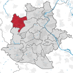
Weilimdorf
|
Weilimdorf City district of the state capital Stuttgart |
|||||||||||||||||||||||||||||||||||
|---|---|---|---|---|---|---|---|---|---|---|---|---|---|---|---|---|---|---|---|---|---|---|---|---|---|---|---|---|---|---|---|---|---|---|---|
| District coat of arms | City map | ||||||||||||||||||||||||||||||||||

|
  |
||||||||||||||||||||||||||||||||||
| List of districts of Stuttgart | |||||||||||||||||||||||||||||||||||
| Incorporation : | April 1, 1933 | ||||||||||||||||||||||||||||||||||
| Height : | 320 m above sea level NHN | ||||||||||||||||||||||||||||||||||
| Population density : | 2,530 inhabitants per km² | ||||||||||||||||||||||||||||||||||
| Postal code : | 70499 | ||||||||||||||||||||||||||||||||||
| Area code : | 0711 | ||||||||||||||||||||||||||||||||||
| Address of the district town hall: |
Löwen-Markt 1 70499 Stuttgart |
||||||||||||||||||||||||||||||||||
| Website: | www.stuttgart.de | ||||||||||||||||||||||||||||||||||
| District Head: | Ulrike Zich | ||||||||||||||||||||||||||||||||||
|
|||||||||||||||||||||||||||||||||||
| Transport links | |||||||||||||||||||||||||||||||||||
| Highway |
|
||||||||||||||||||||||||||||||||||
| Federal road |
|
||||||||||||||||||||||||||||||||||
| Train | S 6 S 60 | ||||||||||||||||||||||||||||||||||
| Light rail | U 6 U 16 | ||||||||||||||||||||||||||||||||||
| bus | 90, N3 | ||||||||||||||||||||||||||||||||||
| Source: Stuttgart data compass | |||||||||||||||||||||||||||||||||||
Coordinates: 48 ° 49 ' N , 9 ° 7' E


.jpg)

Weilimdorf (until 1955 Weil im Dorf ) is a district in the north-west of Stuttgart . It borders on the Stuttgart districts of Zuffenhausen , Feuerbach and Stuttgart-West and the cities of Gerlingen , Ditzingen and Korntal-Münchingen (all three districts of Ludwigsburg ).
geography
Weilimdorf is located at the southeast end of the Strohgau and northwest of downtown Stuttgart (exact location: 48 ° 49 ′ 1 ″ N, 9 ° 6 ′ 40 ″ E - Oswaldkirche). The city district covers an area of 1,258.5 hectares, of which 29.4% are built on, 12.3% are used by traffic structures, 3.9% are green spaces and playgrounds, 23.2% are forest and 28.7% % are used for agriculture. The forest is divided into the Pheasant Garden, the Maierwald and Lemberg, the Föhrichwald and the Solitude Forest . The highest elevations on Weilimdorfer markings are the Green Heiner at 395 m above sea level. NN , the Horn am Lemberg with 380 m above sea level. NN and in the Stammheimer Stellenrain near the "Old Castle" with 443 m above sea level. NN . The lowest point is the point at which the Lindenbach leaves the marker border in the direction of Ditzingen ( 296 m above sea level ). Other heights (all in meters above sea level ): Fasanengarten 338, Tachensee 312, Gehenbühl 332, Altes Schulhaus 311, Bergheim 349, Hausen 308 and Pfaffenäcker 332. Natural waters are the Tachensee , the Lindenbach (10 km), the Schnatzgraben / Rappach (5 km) and the Aischbächle (0.5 km). The Schnatzgraben feeds five small lakes in Bergheim and the Lindenbach feeds the artificially created Lindenbachsee on Goslarer Straße.
The Weilimdorfer mark over time
Over the years, the size of the Weilimdorf markings has changed again and again. At the beginning of the 18th century, 5817 acres (1817.81 ha) belonged to the municipality. After Korntal became independent with 939 acres (293.44 hectares), in 1848 there were still 4,878 acres. In 1861, when the sub-municipality Solitude was formed, the marking decreased by a further 905.75 acres (283.05 ha) and in 1926 still comprised 3958 acres (1248 ha). By exchanging space in the garments Gschnaid, Auf dem Haus, Lotterberg, in the Greuttern as well as in the area towards Solitude, the community gained some space again.
The area distribution in 1848 and 2002
|
|
Districts / coats of arms
coat of arms
The first crest of Weil in the village was just a simple W . Shortly before the First World War broke out, in 1912, the municipality designed a new coat of arms. Like today's coat of arms, it shows the church in the middle of the village in the upper field and a standard in the lower field, which is supposed to show the close affiliation to the Canons' Monastery in Sindelfingen , later to the University of Tübingen . The coat of arms of Weilimdorf got its present form only after the Second World War.
Districts
Bergheim, or more precisely the Bergheimer Hof, has always been on the Weilimdorfer brand and belonged to Weilimdorf. In 1304 the Berg (k) heimer Hof was first mentioned as the upper and lower court. The Nikolaikapelle was first mentioned in 1399 on the site of today's Bergheimer Hof. In 1434 the Bergheimer Hof was sold to Count Ludwig and Ulrich von Württemberg. In 1560 the Rothsche Scheuer was built on the foundations of the former Nikolaikapelle. The arched stones and arched windows ("collapsed 1714, repaired 1714") can still be seen today. In 1765 the Bergheimer Hof had 90 inhabitants. In 1790 the Bergheimer Hof came into the possession of Baron Gottlieb Friedrich von Naso, a former colonel hussar on the Solitude. In 1848/49 his grandson Dr. Friedrich Notter owner of the Bergheimer Hof. He was a member of the state parliament and from 1871 to 1874 a member of the German Reichstag. With him, the Bergheimer Hof became a "court of the muses", which Mörike, Freiligrath, Gerok and Schwab, among others, visited. His literary estate came to the Schillermuseum in Marbach. He died in 1884 in the so-called " Schlößle ", which he had built in 1830 by the builder of Wilhelma, Karl Ludwig Wilhelm von Zanth . It was completely destroyed in World War II. At this point the Villa Ellner was built, in which the Diakonie Stetten is today. From 1953, the rural settlement and the gable were built on. In 1954, the Rottenburg diocese began building to the east of Solitudestrasse, and to the west of Solitudestrasse, the evangelical aid agency on the grounds of the ducal court chamber. In 1960 the Engelberg School and the Weilimdorf Realschule were built. In 1971 the Stuttgart-Weilimdorf grammar school started in the pavilions, in 1975 the newly built grammar school was ready for occupancy and from 1988 it was named "Solitudegymnasium". In 1997 the Bergheim inn was demolished. Today there is a residential complex for the elderly at this point. In 2007, the Diakonie Stetten moved into their residential complex in the former Villa Ellner. The districts of Wolfbusch, Hausen and Giebel, which only emerged in the 20th century, are inextricably linked with the Weilimdorf district.
Previous affiliations

Until 1851, the Kornthaler Hof was also located in Weil im Dorfer Markung, before it became an independent place and offered the Evangelical Brethren a home. Today the former farm is part of the town of Korntal-Münchingen in the Ludwigsburg district . With the formation of the Solitude sub-community , the community of Weil had to give up 283 hectares in the village. In 1942 the Solitude finally came from the Leonberg district to the city of Stuttgart. It is now a district of Stuttgart-West .
history
The place name (Middle High German Wile , New High German Weil ) was expanded to differentiate it from other places in the area called Weil such as Weil der Stadt or Weil im Schönbuch with the addition of “im Glemsgau” or “the village”. Since place names are used much more often in the dative than in the nominative, for example “in Weil, the village”, the form Weil im Dorf, which is based on the dialect ( ze Wil 'em Dorf ) , has appeared since the 17th century .
From prehistory to the first documentary mention
The Weilimdorfer district was already settled in the Hallstatt period. These were probably Celts who farmed and raised cattle. On the Horn near Weilimdorf there was a Celtic fortress and in the Stellenrain high above the Lindental there are still clear signs of a ring wall . The Celts were ousted by the Suebi before the birth of Christ . The Romans then occupied the abandoned land and assigned it to the province of Upper Germany . Traces can still be found on the stone road on the eastern edge of the marking, which was once a Roman road, and in 1910 a Roman wall was excavated in the Blauäcker district. This could have come from a Roman estate and the name Weilimdorf could be derived from this estate: Weil = villa = country house. In 260, however, the Limes no longer held out and the Alemanni pushed the Roman occupiers back to the Rhine. The Alemanni and the Franks divided the Glemsgau after a battle in 496 . The lands to the left of the Glems became Franconian, those to the right of the Glems, and thus the Weilimdorf markings, remained Alemannic. The two churches to the left and right of the Glems (border dioceses of Speyer and Constance) still bear witness to this old separation. In 1075, the Hirsau Monastery received some of its goods from Count Adalbert von Calw , including some of "Weyl".
The Reformation
The first documentary mention of Weilimdorf comes from the year 1243. In it, “Weyl im Glemsgaw” with the church, Widdumhof and other goods is transferred to the Canon Monastery of Saint Martin in Sindelfingen. By a further decree, Sindelfingen was also awarded the Vogtrecht. In 1291 Count Götz von Böblingen attacked Weyl and stole 200 Malter grain. As a result, the community fortified its place, especially the church, Maierhof and Widdumhof, with walls and ditches. In 1336 Weilimdorf came to the Counts of Württemberg by purchase and was assigned to the Oberamt Leonberg. In 1472 the Oswald Church was built in its current form. When the first university in Württemberg was founded in Tübingen, the Oswald Church and the associated goods (including Maier- and Widdumhof) came to the University of Tübingen . Weilimdorf had this administered by a university administrator. Tübingen also had the right to appoint the pastor of Weilimdorf until 1914. Nothing has been handed down from the time of the Peasant Wars and the poor Conrad , but from the beginning Reformation in Württemberg: In a letter dated October 2, 1531, the University Chancellor noted that the residents of Weyl in Glemsgaw felt drawn to Lutheran teachings. In 1533 the university removed the last Catholic pastor of the parish from his office because he was suspected of spreading the Protestant faith. When the Protestant deaneries Leonberg and Cannstatt were formed in 1547, Weilimdorf came to the latter. The first Protestant pastor Samuel Isenmann also created the baptismal register. The Lutheran teaching was consolidated. The community also remained unaffected by the Counter Reformation .
16th century
In the second half of the 16th century, the place saw brisk construction activity. Since 1551 there was a school in Weilimdorf which initially only taught boys in winter. In Württemberg, Duke Christoph did not issue the first school regulations until 1559. In 1559 a new parsonage was built and in 1583 the cemetery was moved from the church to the place where the Seelach School is today. Duke Ludwig von Württemberg supported the construction with 60 guilders. In 1595 the parish renovated its church tower and installed the first clockwork. In the years from 1585 to 1597 the plague ravaged the town several times and killed 387 residents. Towards the end of the 16th century, Weilimdorf showed itself to be a wealthy village, which extended in a semicircle around the church and was fortified with fences, hedges, walls and ditches. In the chronicle of 1926, the Allmandgasse (today's Glemsgaustraße), the Bauerngasse (Ditzinger Straße) and the Gemeine Gasse (?) Are mentioned of the streets that led through the town.
17th century
At the beginning of the 17th century the plague broke out again over the community. 58 people died. In 1622, when the Bavarian General Tilly wanted to march into Württemberg, Duke Johann Friedrich called the people in the Leonberg and Vaihingen regional offices to arms. In the course of the Battle of Ölbronn , 500 people from Württemberg died, including seven from Weilimdorf. The passage of troops from Swedish, French and imperial Habsburg armies plunged the duchy and with it the upper offices and communities into poverty. Bad harvests (1626) and the plague also decimated the population of Weilimdorf. Between 1625 and 1632, 275 people again fell victim to the disease. After the Battle of Nördlingen in 1634, the imperial troops occupied the Protestant Württemberg and kept it occupied until 1638. The troops lived badly among the population and confiscated money and crops. The inhabitants fled into the woods for fear of billeting and further labor. Between 1635 and 1638 a total of 619 people died, including 60 of starvation. Towards the end of the Thirty Years' War , the Oberamt Leonberg raised a total of 52,919 guilders through billeting. After the end of the war in 1648, the community was in ruins and the fields and vineyards were uncultivated. The town regained its strength through good harvests in the following years. 1693: In order to free the French held in Württemberg, French soldiers took up positions between Oberriexingen and Gerlingen. They threatened to set fire to villages if the hostages were not released. Before the allotted time was up, Weilimdorf and Fellbach broke out. The church was also looted and the French took away both the town hall and church bells. In the following years, billeting, deliveries in kind and looting continued to be dominated. It continued during the War of the Spanish Succession (1701–1714).
The 18th century
In 1707 the French troops caused great damage (over 1,943 guilders ). The municipality compensated for this through the Württemberg countryside with 406 guilders and 31 cruisers. At the turn of the century, new local streets were built again: the “Krumme Gasse”, the “Schmale Gasse” (today Dachtlerstrasse) and the “Keimengäßle”, which is divided into the “Hirschgäßle” (Kimmichstrasse) and the “Webergäßle” (Spießgasse). In August 1710, Markus Hellwag came to Weilimdorf as the new university nurse. In 1716 he built the "Linde", a manorial house, outside the actual village on today's Ditzinger Straße. In 1718, Weilimdorf came through the construction of Ludwigsburg and the establishment of the Oberamt of the same name from the Oberamt Leonberg to the Oberamt Cannstatt . During the War of the Polish Succession , the War of the Austrian Succession and the Seven Years' War , the population repeatedly suffered from the marching through of the troops and billeting. Only in 1763 did calm return. However, the Weilimdorfer farmers drove Fronen for Duke Carl Eugen, who had the Solitude Castle built above the community in the period from 1763 to 1767, partly on its landmarks. As a result of the palace construction, a straight road was built between Solitude Palace via Weilimdorf, Korntal, Stammheim, Kornwestheim and Ludwigsburg. Today's Solitudestrasse served as the basis for the state survey of Württemberg in the mid-19th century. The Duke's construction work also affected the place. The first house on Solitudestrasse was the “Gasthaus zum Ritter Georg”, where horses were also parked to change. The old school building was also demolished and a new building was built for it for 1,500 guilders. On August 17, 1797, flames raged in the village. The tithe barn, some houses and barns burned down. Soldiers who were quartered during this period helped extinguish the fire and thus prevented the flames from spreading to the church. The tithe barn was rebuilt in 1798.
19th century
The fields were neglected due to the Napoleonic Wars and the associated troop movements, so that an emergency arose in 1816. In order to counteract this famine, the pastor and the mayor founded a charity in 1817. Through this 434 guilders and 17 kreuzers in kind were collected and given out to the needy. This was followed by further bottlenecks in the food supply due to hail damage in 1837, 1838 and a drought in 1847. As a result, the community's poor relief began again. Little is known of the revolution of 1848 . Some of the citizens were among the supporters of Friedrich Hecker, others were preparing to fight the revolutionists and the French. The 19th century brought a lot of relief for the residents. In 1818 serfdom was abolished, in 1836 the end of compulsory labor was announced and in 1849 money levies were introduced instead of tithing. So it happened that agriculture flourished again. In 1850 there were 596 cattle, 42 horses, 238 pigs, 79 goats and 84 colonies of bees in Weil in the village. In terms of buildings, there were 212 houses and 184 barns and other outbuildings. Some houses that were demolished by the Solitude were rebuilt in Weil im Dorf. Bergheimer Straße was also built in 1849. After the new years of failure from 1852 to 1854, 62 citizens emigrated. Another 24 followed. Through the relief towards the rulers, prosperity increased and much was renewed and built in the place. Due to the increased number of students, it was necessary to expand the school and set up another teaching post. In 1851 the place got a handicraft school for girls and in 1865 a school for small children. The population continued to grow, so that the cemetery needed more space and in 1869 had to be relocated to the "Hipplen" garb.
The 20th century
In 1929 Weil im Dorf, Oberamtsiertel Leonberg ( Württemberg ), and the neighboring city of Feuerbach , which belonged to the Oberamt Stuttgart-Amt , merged to form the new city of Feuerbach-Weil im Dorf, but the enlarged city was incorporated on May 1, 1933 Feuerbach-Weil in the village to Stuttgart. Then Feuerbach and Weil were run as districts in the village. During the Second World War, Weil was hit by heavy air raids in the village. Only nine months before the end of the war, the aerial warfare in July 1944 claimed the first eleven victims among the Weilimdorf civilian population. While the western front was drawing closer and the end of the war was in sight, there were another 16 victims in October 1944. On January 28, 1945, 353 British bombers attacked Stuttgart shortly before midnight. Weilimdorf was a focus of the attack. For Weilimdorf it was the heaviest night of bombing in the entire war, and it also claimed the most deaths. Most of the dead were women and children. In the old cemetery, the grave field "Fliegeropfer 1944–1945" commemorates the dead in the air war in Weilimdorf. 44 names are mentioned on the ten tombstones. In fact, there were many more victims. 103 people were victims of the bombing war in Weilimdorf, 44 of them were slave laborers. 241 Weilimdorfers lost their lives as soldiers on the battlefields of World War II .
In 1955 the spelling "Weilimdorf" was determined by the state government . When the city of Stuttgart was divided into boroughs in 1956, the Weilimdorf district with the Bergheim district developed between 1940 and 1955, the Giebel district developed from 1953, the Hausen district developed from 1948 and the Wolfbusch district built in 1932-1934 and 1950/51 Weilimdorf district united. When the Stuttgart districts were reorganized on January 1, 2001, another Weilimdorf-Nord district was separated from the Weilimdorf district. Since then, the Weilimdorf district has been divided into six districts .
population
The Weilimdorfer population development presented on the basis of various data. Regular censuses only started in 1786. Between 1350 and 1786, the population of Weilimdorf was between 400 and 900 inhabitants. After the end of the Thirty Years' War, Weil lost almost all of its population in the village. With the economic boom in the 19th century and the incorporation into Stuttgart, the community grew bigger and bigger. After the end of the World War and the creation of the newer residential areas Wolfbusch, Bergheim, Hausen and Giebel, the population continued to increase. For six years it has remained almost constant at 30,000.
|
|
|
Politics and administration
Weilimdorf has been part of the city of Stuttgart since 1933. Since then, the citizens no longer elect their own municipal council, but take part in the municipal council elections in Stuttgart. A mayor has also not been elected since then. At the head of the city district is therefore a district chairman appointed by the mayor. This is currently Ulrike Zich. The district head presides over the district advisory board.
Due to the number of inhabitants in the district, the Weilimdorf district advisory board has 16 full and as many deputy members. The following distribution of seats has been in effect since the last local elections in 2014:
- CDU: 5th
- B90 / The Greens: 3
- SPD: 2
- FDP: 1
- Free voters: 2
- SÖS / DIE LINKE: 2
- AfD: 1
In addition to the district advisory board, there is also a youth council in Weilimdorf , which is elected by young people between the ages of 14 and 18 and advocates their interests.
Weilimdorf is the seat of numerous institutions in the state capital: the district office with the citizens' office, social services, the registry office, the youth welfare office and other offices. The Weilimdorf district library of the Stuttgart City Library is also located in the district town hall . In the library a selection of around 30,000 books and 15,000 other media is made available to users.
The voluntary fire brigade Weilimdorf as a department of the FF Stuttgart is responsible for the fire protection of the city district together with the guard 4 of the professional fire brigade. In 2008 the department moved from the old magazine to its new domicile in the lower Glemsgaustraße.
In addition, there are two readiness lines of the German Red Cross in the city district: readiness numbers 12 (Weilimdorf) and 13 (gable). Through their voluntary work, they make a contribution to civil protection and disaster control, for example through the Giebel Rapid Response Group of the DRK Stuttgart.
Furthermore, Weilimdorf was the headquarters of the Weilimdorf police station of the Stuttgart police headquarters . In the course of the savings made by the Baden-Württemberg police and thus also by the Stuttgart police, the structure of the district in Stuttgart was changed in 2009. This also affected the Weilimdorf district, which, as the Weilimdorf police station, is now a branch of the police station 8 Kärntner Straße.
Responsible District Court for the District, the District Court Stuttgart-Bad Cannstatt in the District Court of Stuttgart in the Higher Regional Court of Stuttgart .
Weilimdorf is also the seat of the Royal Thai Honorary Consulate in Stuttgart.
Churches


Since 1549, when the first Protestant pastor took up his office, the Protestant church was dominant in Weilimdorf. Only with the arrival of ethnic Germans and other displaced persons as well as guest workers in early 1960 did the Catholic Church gain its current importance. From 1858 the members of the Evangelical Methodist Church also gathered , which from 1922 also owned a parish hall. The believers of the New Apostolic Church in Weilimdorf have been holding divine services since 1919 . The Church of Jesus Christ of Latter-day Saints ( Mormons ) has also had a meetinghouse on Deidesheimer Strasse since 1981 .
Protestant church
For a long time, the Oswald Church was the only church in town. Only after the Weilimdorfer district began to be settled in 1935 did new parishes and churches gradually emerge. These in turn merged to form the " Evangelical General Church Community Weilimdorf ". Today this consists of the parishes of Oswald, Dietrich-Bonhoeffer, Wolfbusch and Stephanus.
Oswald Church
The Oswaldkirche already existed at its current location as a church in simple wood construction from the 8th / 9th. Century. The listed Oswald Church in its current form was built around 1472. At that time, the nave was added to the tower, which was built between 1131 and 1181. The building was first documented in 1243 as a church in Weil im Glemsgau. The church designated Saint Oswald as the patron saint.
Today the community consists of two parishes. The Oswald church community maintains a kindergarten, a parish hall on Ludmannstrasse and the Greuttersaal, in which services are held. The kindergarten belonging to the Oswald community was demolished in July 2007 and replaced by a functional new building.
Wolfbusch Church
The Wolfbuschkirche was built together with the Wolfbuschsiedlung in 1938. During the Second World War , the church was badly damaged and could only be put back into operation after a renovation in 1947. In 1966 the Wolfbuschgemeinde separated from the Oswaldgemeinde and became independent.
Today it maintains a rectory, a parish hall on Gemsenweg and a kindergarten next to the church.
Stephanuskirche

The Stephanuskirche was established with the creation of the Giebel district. The first parish office has existed since 1956. The second was added a year later. But it wasn't until 1958 that the church itself was consecrated. The congregation is located in Giebelstrasse, on whose area the church, the parish hall, the kindergarten and the diakonia are located. The Jakobuskirche in Hausen also belongs to the Stephanus parish.
Dietrich Bonhoeffer Community Center
With the settlement of the "Pfaffenäcker" in 1979, a church was also necessary. The community center on Wormser Strasse consists of the church as well as the two parish offices, the kindergarten and the community hall.
Institutions of the general parish
A Diakoniestation has existed since 1904 , which merged in 2005 with the station of the parish from Feuerbach to form the new Diakoniestation Im Stuttgarter Norden gGmbH . The administration of the joint Diakoniestation was based in the Weilimdorf nursing home on Giebelstrasse in Weilimdorf. Since 2010 the Diakoniestation Im Stuttgarter Norden gGmbH belongs to the Diakoniestation Evangelischer Kirchenkreis Stuttgart , which in turn has been part of the new Diakoniestation Stuttgart since 2011 . However, the Weilimdorf care area continues to exist unchanged. The nursing sector is still supported today by the Evangelical Nursing Association. Furthermore maintains the Evangelical Church in Weilimdorf the Kirchenpflege in Ludmannstraße, the church registry office and the Waldheim in Lindental.
Catholic Church

Saint Theresa of the Child Jesus
In 1952 the parish began building its church on Rastatter Strasse, held the first service at Christmas 1952 and finally consecrated it on May 3, 1953. The community also includes a kindergarten, a nursing association and a community hall.
Since 1978 the congregation has participated in the carol-singing campaign of the Children's Mission.
Salvator
The church was built in 1956 and 1957. The corrugated roof of the nave is unique. In 1970 the church got another organ. The diocesan conservator Wolfgang Urban paid tribute to the Salvator parish church in 2008 . The Salvator community has a kindergarten and a parish hall in the immediate vicinity of the church as well as another kindergarten in Bergheim.
Economy and Infrastructure
economy
.jpg)
Weilimdorf is the second largest business location in the state capital. It currently has an area of 132 hectares. 20,000 people are employed in 259 companies in the industrial park. Well-known companies such as the M + W Group , Godel-Beton , Siemens , Porsche , Vector Informatik , the pharmaceutical wholesaler Andreae-Noris Zahn and the roof system manufacturer Paul Bauder are located in the industrial area. The streets of the industrial area were named after towns to the west of the state capital such as Rutesheim , Mönsheim or Friolzheim . Despite the extensive settlement of the Weilimdorfer Markung, there are still farms in their main occupation. The Bergheimer Hof, for example, is one of the few companies in Germany that produces premium milk.
traffic
Weilimdorf is close to the A 81 motorway ( Heilbronn –Stuttgart– Gottmadingen (near Singen )) and the Leonberg triangle , where it meets the A 8 ( Karlsruhe –Stuttgart– Ulm - Munich ). Furthermore, the B 295 (Stuttgart – Leonberg– Calw ) leads around the town. The Bergheimer Steige, which is closed to truck traffic, is also of importance as the shortest connection from Weilimdorf to Leonberg, to the Fildern and to Stuttgart Airport .
Weilimdorf has been connected to local public transport since 1926. Before that there was only the Reichsbahnhof Korntal-Weil in the village on the Black Forest Railway . The Feuerbach municipal tram then ran from the Reichsbahnhof Feuerbach via Weilimdorf to Gerlingen. With the incorporation of the city of Feuerbach-Weil in the village in 1933, it came into the possession of the Stuttgarter Straßenbahnen AG (SSB). In 1992 the route was converted to light rail operation with the start of the U6 line . In 1997, when line 13 was converted to light rail, the last GT4 went to Weilimdorf. With the growth of the industrial area, the city district on the Mittlerenpfad got its own S-Bahn stop on the S6 in December 1988 . This is listed in the Deutsche Bahn AG station category 4 as a highly frequented local transport stop . In addition, the bus route 90, operated by the private company Seitter on behalf of SSB, connects Korntal with Weilimdorf, the industrial area, train station, Hausen and Giebel. On weekends and before public holidays there is a connection to downtown Stuttgart with the N3 night bus.
- U 6 Gerlingen - Weilimdorf - main station - Degerloch - Möhringen - Fasanenhof
- U 16 Giebel - Weilimdorf - Bad Cannstatt - Fellbach (duringrush hour)
- S 6 Weil der Stadt - Leonberg - Weilimdorf - Zuffenhausen - Nordbahnhof - Hauptbahnhof - Schwabstrasse
- S 60 Schwabstraße - main station - north station - Zuffenhausen - Weilimdorf - Leonberg - Renningen - Böblingen
- 90 (Borkumstraße / Neuwirtshaussiedlung -) Korntal - Weilimdorf - industrial area - train station - Hausen - gable
- N3 night bus Schlossplatz - main station - Feuerbach - Weilimdorf - Gerlingen (Fri / Sat / Sun night)

Schools and youth
In Weilimdorf there are five primary schools, three secondary schools, one comprehensive school and one grammar school. The special needs school is also located in the Seelachschule. The Wolfbuschschule got a Werkrealschule in the 2012 school year, so that this type of school can now also be found in Weilimdorf.
Elementary and secondary schools
- Wolfbuschschule, Köstlinstraße 76-77 (Werkrealschule)
- Reisachschule, Maierwaldstraße 14
- Engelberg School, Engelbergstrasse 83
- Maria Montessori School, at the Pheasant Garden 9
- Rappach School, Sandbuckel 45
- Special school: Seelachschule, Glemsgaustraße 6
Realschule and grammar schools
- Comprehensive School (former Realschule) Weilimdorf, Engelbergstrasse 81
- Solitude-Gymnasium, Spechtweg 40
freetime and sports
Because it is part of a big city, Weilimdorf has an extensive range of cultural activities in the vicinity. The Stuttgart city center with its shopping and nightlife options is 20 minutes away by tram . In Weilimdorf itself there is a relatively large amount of green available for recreational activities. There are fitness trails in the pheasant garden. Otherwise the forest or a field can be reached in less than five minutes. The Green Heiner is popular with model airplane pilots. There are numerous large and small playgrounds for children. There are also four sports clubs in the village: the pure basketball club BBC Stuttgart, eV, TSV Weilimdorf e. V., SG Weilimdorf e. V., Spvgg gable.
media
In Weilimdorf the magazine In & um Weilimdorf appears weekly with the official announcements of the district town hall and other local news, the Stuttgarter Wochenblatt (local edition), the Weilimdorfer Anzeiger and as a supplement in the Stuttgarter Zeitung and the Stuttgarter Nachrichten the local section Nord-Rundschau . The website www.weilimdorf.de, which is maintained by the Aktiongemeinschaft Weilimdorf - at the foot of the Solitude, an association of local companies, also offers current news .
Culture and sights
- Weilimdorfer Heimatstube in the former rectory with exhibitions on the history of Weilimdorf
- Old town hall Weilimdorf from 1551
- Evangelical parish church St. Oswald - built in the 12th century, with valuable interior fittings
- Hunting pavilion in the pheasant garden between Hausen and Giebel
- Wind turbine Grüner Heiner
- Former Vogtei in Weilimdorf - built in 1716 as the Vogtei of the University of Tübingen
- Hasenbrünnele in the Lindental
- Ruins of Dischingen Castle
- Atonement cross at the entrance to the residential complex on Lindenbachsee
- Solitudestrasse as the basis of the national survey of 1820
The Solitudeallee, completed under Duke Carl Eugen in 1769, was not allowed to be used by the common people. - Wolfbuschschule
The Wolfbuschschule was opened for the first time on April 4, 1936. The old school building is a listed building. - Evangelical Church in Wolfbusch
- Salvatorkirche in the gable
On October 26, 1956 the foundation stone was laid and on November 20, 1957 the consecration by Bishop Carl Joseph Leiprecht. The church was dedicated to Salvator mundi , the “Savior of the World”. The new parish hall was inaugurated on January 23, 1988. - Greutterwald nature reserve
- Landscape protection areas in Weilimdorf
- Tachensee
- Memorial and memorial on the new cemetery at Köstlinstrasse 185 from 1969 by the sculptor Suse Müller-Diefenbach in memory of the dead in the world wars and the victims of the Nazi tyranny

Solitude Castle

The “Green Heiner” seen from afar from the Weilimdorf industrial area in autumn

The “Green Heiner” in autumn

Weilimdorf, part of the industrial area in the foreground, seen from the “Green Heiner”

Mountain sequoia trees in the Solitude Forest
Tachensee


Buildings
Oswald Church
→ Parish church St. Oswald (Weilimdorf)
.jpg)
.jpg)
Dischingen Castle
The sex of the noblemen of Dischingen is recorded in the camp books of the community of Weilimdorf. It appears in Weilimdorf between the 12th and 14th centuries. They lived in their hilltop castle above the Lindenbach in the garb of Stellenrain, southwest of Weilimdorf. In the 12th century the castle, which was probably made of wood, burned out. The castle was rebuilt in the same place, but made of stone. After another fire in 1311, Dischingen was finally given up. After looting in the 14th and 15th centuries and the excavation of a quarry near the castle, it fell into disrepair. Subsequently, the exact location of the ruins was not known for centuries . It was not until 1950 that the old robber's castle (popularly known as the nickname) was excavated and restored to its present state. Some old pottery shards were also found during the excavations. The remains provide information about what the fortress might have looked like:
- 20 meter high keep
- Residential building (basement entrance and steps still clearly visible today)
- 10 to 12 meter high shield wall between the keep and the residential building
- deep moat with ramparts and palisade structure
- northwest a bailey
400 m south of Dischingen Castle is another moat from the former Altdischingen Castle .
Hasenbrünnele
After some paths in the Lindental had to be rebuilt or paved, some of the sources of the Lindenbach were combined in a well. The sculptor Fritz von Graevenitz ( Solitude ) designed the motif with two rabbits in 1955, which adorns the source. However, the water quality of the well is not sufficient to classify the water as drinking water.
Hunting pavilion in the pheasant garden

In 1765, Duke Carl Eugen founded a pheasantry in the Hardtwald on the Weilimdorf district. In this a pheasant master raised up to 600 pheasants per year. The duke now organized regular hunts in the pheasant forest (Hardtwald). The farmers in the community had to provide fodder, firewood and other goods for the pheasantry and at the same time feared for the harvest, as the pheasants damaged the fields so that the harvest declined. It was not until 1818 that the hunting pavilion and the supply building for the pheasantry were built. The pavilion itself is a twelve-sided classical building. A golden pheasant is attached to its roof as a wind vane. Four avenues lead straight to the pavilion. The dukes and kings of Württemberg shot pheasants on these avenues until 1918. After the abdication of Wilhelm II , the population also enjoyed the forest and after the Second World War the forest research institute moved here, which has since been closed and relocated to Freiburg. The State Forestry Office still maintains a depot here today. With the administrative reform, the state forest administration was dissolved and incorporated into the Stuttgart city administration.
Water sculpture
The sculptor Jörg Failmezger designed a walk-in water sculpture for the Löwenmarkt , which was inaugurated in 1985.
Forests, lakes, green spaces and parks

Daimlerplatz wetland
The Daimlerplatz wetland (also popularly known as the Panzersee) is located in the Solitude Forest between Weilimdorf and Solitude Castle on the "Sandkopf". The flat terrain in the middle of the forest was initially used by the population from the middle of the 19th century to extract silica sandstone from simple pits. An air raid during the Second World War, in which a large area of forest was destroyed, subsequently became swampy. From 1949, Daimler-Benz AG used the site to test its trucks for off-road capabilities. The fairways increasingly compacted as a result of these test drives, so that the rainwater no longer ran off. In 1975 the test drives in favor of nature conservation ended. The name, however, remained. A great variety of newts, frogs and other amphibians and reptiles had settled here. In 2002 and 2003, when the area slowly silted up, the Forestry Department took measures to protect biodiversity. This has been proven, so that even today pond frog , agile frog , Alpine Newt , grass snake and forest lizard and other species can be observed.
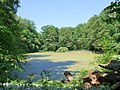
Lindenbachsee

The Lindenbachsee (popularly known as "Entensee") is a reservoir of the Lindenbach at the foot of the "Horn". It is 150 meters long and 40 meters at its widest point. In the past, ice was cut here in winter. Today, the lakeshore is firmly in the hands of those looking for relaxation who sit on benches, do their laps or let model boats sail on the water.
Lindenbach
At 10 km, the Lindenbach is the longest brook in Weilimdorf and usually the only one that still carries water during longer periods of dryness. It drains an area of 29 square kilometers. It rises near Solitude Castle and then leads through the valley ditch to Hasenbrünnele. Then its course leaves the forest and flows through the wide Lindentale past the forest homes of the Evangelical, Catholic and Methodist Churches. After passing the Lindentalbrücke, over which the B 295 leads, its course crosses several gardens and finally feeds the Lindenbachsee on Goslarer Straße and Lindenbachstraße. He leaves this on a partially renatured path and sinks into the sewerage shortly before the city center. From this it emerges again in the "Unterdorf" and runs parallel to Glemsgaustrasse and Lotterbergstrasse into the industrial area. At Hemminger Straße, its course joins the Lachengraben coming from Korntal and continues towards Ditzingen, where it flows into the Glems. The water quality in the upper reaches between Quelle and Hasenbrünnele is classified as low pollution with water quality classes I-II. The Lindenbach between Lindental and Lindenbachsee has quality class II (moderately polluted). From there, the stream is categorized in quality class II-III (critically polluted) due to partial pollution from the mixed water sewer system up to the city limits. Around 60 percent of the water is classified as near-natural, and another two kilometers can be renatured.
Celebrations and events
Every year on December 31st ( New Year's Eve ) the Stuttgart New Year's Eve run from Weilimdorf takes place around the pheasant garden and back. There is a main run (11,111 m), a Hörnleshasenlauf (5,555 m) and a school run (2,300 m). This event attracts numerous followers and spectators every year. Furthermore, the music association, the Weilimdorf choir association, the wrestlers of the SG Weilimdorf and other local associations organize their annual Hocketse ; Every two years an open day takes place at the Weilimdorf volunteer fire brigade . On July 15, 2006, a city festival took place for the first time, in which all associations and many companies took part.
Say
There are a few legends from previous centuries about Weilimdorf. The best-known is that once in the summer Duke Carl Eugen had the Solitude-Allee from Ludwigsburg to Solitude sprinkled with salt so that he could take his company to his castle by sledge. Several ghosts and undead are said to have been seen from time to time. It is reported that a white pig is walking around in Krummen Gasse (today's Dachtlerstrasse). A rider without a head has already been seen in the Lindental . Several undead are also said to walk around their old place of work in their previous function as woodruff, mayor and castle owner of the night.
Literature and homeland books
- Oberamtsbeschreibung Leonberg 1852
- Wilhelm Ostertag , in: Chronicle of Weil im Dorf, Stuttgart, 1926. Quoted: Ostertag , page number.
- Heinrich Schmidt , in: Weilimdorfer Pictures and Stories, Stuttgart 1969.
- Weilimdorfer Heimatkreis , in: 750 Years of Weilimdorf, Stuttgart 1993.
- Brockhaus , in: Brockhaus Enzyklopädie in 17 volumes, Leipzig 1901.
- Dieter Hagenmüller , in: The pheasant garden through the ages, Stuttgart. Quoted: Hagenmüller , page reference.
- Dr. Günther Widmer (Ed.) , In: Ortsfamilienbuch zu Weil im Dorf, Stuttgart 2007.
- Weilimdorfer Heimatkreis , in: Heimatblätter, Stuttgart 1989 to 2007.
swell
- ↑ "For comparison, acres were converted into hectares (1848) and vice versa (2002)."
- ↑ " Ostertag , p. 73."
- ↑ Ostertag , p. 9.
- ↑ Ostertag , p. 10.
- ↑ Ostertag , p. 11.
- ↑ Ostertag , p. 16.
- ↑ Ostertag , p. 19.
- ↑ Weilimdorf district library - profile. Retrieved October 27, 2018 .
- ↑ Royal Thai Honorary Consulate. Retrieved October 27, 2018 .
- ^ Cf. [Wolfgang Urban]: Parish Church Salvator, Stuttgart [-Weilimdorf] -Gable . Kunstverlag Fink, Lindenberg 2008, ISBN 978-3-89870-489-2 .
- ↑ Stuttgarter Nachrichten , of September 26, 2007, page 24.
- ↑ Memorial sites for the victims of National Socialism. A documentation, volume 1. Federal Agency for Civic Education, Bonn 1995, ISBN 3-89331-208-0 , p. 91.
- ↑ Hagenmüller , p. 9.
- ↑ a b c State Capital Stuttgart, Water Report 2003, page 43.
- ^ State capital Stuttgart, Water report 2003, page 44.
- ^ Graf, in: The legends around Stuttgart, page 47.
- ^ Graf, in: The legends around Stuttgart, page 46.
Web links

Inner city districts: Stuttgart-Mitte | Stuttgart-North | Stuttgart-East | Stuttgart-South | Stuttgart-West
Outer boroughs: Bad Cannstatt | Birkach | Botnang | Degerloch | Feuerbach | Hedelfingen | Möhringen | Mulhouse | Munster | Obertürkheim | Plieningen | Sillenbuch | Stammheim | Untertürkheim | Vaihingen | Cheeks | Weilimdorf | Zuffenhausen