Rutesheim
| coat of arms | Germany map | |
|---|---|---|

|
Coordinates: 48 ° 49 ' N , 8 ° 57' E |
|
| Basic data | ||
| State : | Baden-Württemberg | |
| Administrative region : | Stuttgart | |
| County : | Boeblingen | |
| Height : | 447 m above sea level NHN | |
| Area : | 16.22 km 2 | |
| Residents: | 10,916 (Dec. 31, 2018) | |
| Population density : | 673 inhabitants per km 2 | |
| Postal code : | 71277 | |
| Area code : | 07152 | |
| License plate : | BB, LEO | |
| Community key : | 08 1 15 042 | |
| City structure: | 2 districts | |
City administration address : |
Leonberger Strasse 15 71277 Rutesheim |
|
| Website : | ||
| Mayor : | Susanne Dornes | |
| Location of the city of Rutesheim in the Boeblingen district | ||
Rutesheim is a town in Baden-Württemberg and belongs to the Boeblingen district .
geography
Rutesheim is located in the southwest corner of the Strohgau , which is part of the Neckar Basin natural area . The city directly on the federal motorway 8 (A8) is five kilometers from Leonberg and seven kilometers from Heimsheim .
Neighboring places
Neighboring settlements are (clockwise from the northeast) Heimerdingen , Gebersheim , Leonberg , Eltingen , Warmbronn , Renningen , Malmsheim , Heimsheim , Flacht and Weissach .
Community structure
In addition to Rutesheim, the Rutesheim-Heuweg settlement and the abandoned villages of Aichingen, Bechingen, Miemingen and Hennenhäusle belonged to the municipality of Rutesheim within the limits of December 31, 1971 . On January 1, 1972, the neighboring village of Perouse was incorporated, and in 2008 the entire municipality was elevated to a town. Around 1,200 people live in the Perouse district.
history
Rutesheim
Rutesheim, previously also written as "Ruthemsen", was first mentioned in 767 in a document from the Lorsch monastery . Politically, from around 750 Rutesheim belonged to the Glemsgau , a district owned by a Gaugrafen, which from the 13th century only served as a regional designation and as such was replaced by the " Strohgäu ". Rutesheim was bought by the county of Württemberg at the beginning of the 14th century . In the 15th century, Rutesheim was part of the Böblingen widow estate of Archduchess Mechthild . Later the village came to the Oberamt Leonberg and remained there after the implementation of the new administrative structure in the Kingdom of Württemberg . On June 30, 1837, 120 buildings were lost in a fire. In 1869, with the opening of the station on the Black Forest Railway, it was connected to the Württemberg railway network . During the district reform in Württemberg during the Nazi era , Rutesheim became part of the expanded district of Leonberg in 1938 . In 1945 Rutesheim came under the American zone of occupation and thus belonged to the newly founded state of Württemberg-Baden , which was added to the state of Baden-Württemberg in 1952. In 1973, the district reform in Baden-Württemberg took place , when Rutesheim became part of the Boeblingen district.
Perouse
Perouse, which was incorporated on December 1, 1971, was created by the settlement of 71 Waldensian families who named their community, founded on June 13, 1699, in memory of their original home community Perouse (today Perosa Argentina ) in Piedmont. Duke Eberhard Ludwig von Württemberg had offered the Waldensians expelled from France the land.
City elevation
By resolution of the state government on January 22, 2008, Rutesheim was given the name “ City ” on July 1, 2008 . On June 26, 2008, Prime Minister Oettinger presented the town charter in a ceremony.
Population development
These are population numbers according to the respective territorial status. The numbers are census results (¹) or official updates from the Baden-Württemberg State Statistical Office (only main residences ).
|
|
religion
In terms of canon law, Rutesheim belonged to the Roman Catholic land chapter Grüningen in the Speyr archdeaconate Trinitatis until the Reformation .
Since the Reformation in the Duchy of Württemberg in 1534, the place belonged to the Protestant superintendent Leonberg. The Lutheran churches in Rutesheim are within the Evangelical Church the church district Leonberg assigned.
After the Second World War, many new citizens of different denominations came . There are six parishes in the city of Rutesheim: three Protestant (Rutesheim, Perouse and Heuweg-Silberberg), one Methodist , one Catholic and one New Apostolic community, and one Old Pietist community.
politics
mayor
In the mayoral election on February 4, 2018, Susanne Dornes was elected the new mayor with 70.87% of the valid votes and took office on April 1, 2018.
Municipal council
In Rutesheim, the municipal council is elected using the spurious selection process . The number of local councils can change due to overhang mandates . The municipal council in Rutesheim has 19 members since the local election on May 26, 2019 (previously: 20). The municipal council consists of the elected voluntary councilors and the mayor as chairperson.
| Parties and constituencies |
% 2019 |
Seats 2019 |
% 2014 |
Seats 2014 |
||
| BWV | Civic voter association Rutesheim | 27.98 | 5 | 28.82 | 6th | |
| CDU | Christian Democratic Union of Germany | 21.04 | 4th | 24.16 | 5 | |
| UBR | Independent citizens of Rutesheim | 24.23 | 5 | 23.56 | 5 | |
| GABL | Green alternative citizen list | 16.78 | 3 | 15.77 | 3 | |
| SPD | Social Democratic Party of Germany | 9.98 | 2 | 7.69 | 1 | |
| total | 100.0 | 19th | 100.0 | 20th | ||
| voter turnout | 65.61% | 55.73% | ||||
coat of arms
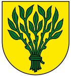
Blazon: a bundle of green rods in gold.
Partnerships
Rutesheim maintains some intercommunal contacts:
-
 Scheibbs in Lower Austria (partnership since 1972)
 -
 Saalburg-Ebersdorf in Thuringia (contacts since 1989)
 -
 Perosa Argentina in Northern Italy (friendship treaty 2008, partnership since 2017)
Infrastructure and economy
traffic
Rutesheim is located directly on the Autobahn 8 (A8), 5 km from Leonberg , 18 km from Stuttgart- Mitte and 22 km from Stuttgart Airport and the New Fair. In September 2008, after the six-lane expansion of the A8, the Rutesheim junction was opened to traffic. The bypass road (north bypass Rutesheim) has been relieving the city center of through traffic since July 2007 and connects the Schertlenswald industrial park with the motorway without passing through . The Perouse district will now be completely relieved of through traffic with a second bypass opened in 2017.
The city is connected to the rail network via the Black Forest Railway. The S6 ( Weil der Stadt - Leonberg - Stuttgart ) and S60 ( Böblingen - Renningen - Stuttgart ) lines of the Stuttgart S-Bahn run on this route with a stop at the Rutesheim S-Bahn station. This is located 2.5 km from the center of Rutesheim in the area of the Leonberg district of Silberberg, connected by a VVS city bus.
Established businesses
In Rutesheim mainly medium-sized businesses and craft businesses are based. The Rutesheim location of Robert Bosch GmbH employs around 600 people. The Porsche company with around 400 employees was relocated to Rutesheim in 2013. The mechanical engineering company Voith produces hydraulic parts at its Rutesheim location.
Educational institutions
With the Gymnasium , the Realschule and the Theodor-Heuss -Schule ( elementary and Werkrealschule ) Rutesheim has three schools. All three have open, all-day deals. A new cafeteria with auditorium was built in the school center for this purpose. The bus services to the schools are handled by the companies Wöhr-Tours from Weissach and Seitter from Friolzheim . There are also ten kindergartens and crèches.
Culture and sights
- Häsel fruit variety plant: plants with around 190 old fruit varieties
Buildings
- Rathaus Rutesheim (Geographic coordinates: 48 ° 48 ′ 28 ″ N , 8 ° 56 ′ 50 ″ E )
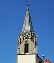
- Evangelical Johanneskirche Rutesheim (Geographical coordinates: 48 ° 48 ′ 32 " N , 8 ° 56 ′ 34" E ). In 1789, the church council builder Wilhelm Friedrich Goez from Ludwigsburg rebuilt and expanded the church in the style of that time. In 1854, the tower was given its current shape based on a design by architect Christian Friedrich Leins . In 1956 the church interior was fundamentally redesigned. In 2017, roof renovations and modernizations were necessary.
- Rutesheimer Wasserturm (Geographic coordinates: 48 ° 48 ′ 32 ″ N , 8 ° 55 ′ 58 ″ E )
Personalities
- Wilhelm Kopp (1856–1910), Protestant pastor, born in Perouse
- Georg Schmidgall (1867–1953), leading student historian, born in Rutesheim
- Heinz Fuchs (1934–2012), entrepreneur and racing car designer
- Wolfgang Kermer (* 1935), art historian and university rector, lived in Rutesheim from 1970 to 1982
Sports
The SKV Rutesheim (sports and cultural association) operates the football , handball , gymnastics , volleyball , table tennis , sports badges , running , walking and singing departments . The soccer department plays with its active teams in the Association League Württemberg (I.) and the District League Enz / Murr (II.), The greatest success was the promotion to the then third-class amateur league Württemberg in 1976.
The CVJM Rutesheim is multiple German oak cross master in Indiaca .
Individual evidence
- ↑ State Statistical Office Baden-Württemberg - Population by nationality and gender on December 31, 2018 (CSV file) ( help on this ).
- ↑ Natural space unit 123; See map no.170 (Stuttgart) for the natural structure edited by Friedrich Huttenlocher and Hansjörg Dongus, Institute for Regional Studies, Bonn 1966
- ^ The state of Baden-Württemberg. Official description by district and municipality. Volume III: Stuttgart District, Middle Neckar Regional Association . Kohlhammer, Stuttgart 1978, ISBN 3-17-004758-2 , pp. 118-120
- ^ History of Rutesheim at LEO-BW (regional studies of Baden-Württemberg online)
- ^ Federal Statistical Office (ed.): Historical municipality directory for the Federal Republic of Germany. Name, border and key number changes in municipalities, counties and administrative districts from May 27, 1970 to December 31, 1982 . W. Kohlhammer, Stuttgart / Mainz 1983, ISBN 3-17-003263-1 , p. 452 .
- ↑ StBA Area: changes from 01.01. until December 31, 2008
- ↑ Population development in Baden-Württemberg from 1871 to 2012 ( page no longer available , search in web archives ) Info: The link was automatically marked as defective. Please check the link according to the instructions and then remove this notice.
- ↑ The Archdiakonat Trinitatis , which belonged to the “ Stiftspropst bei Allerheiligen ”, was divided into the rural chapters Weil der Stadt , Grüningen (today Markgröningen) and Vaihingen an der Enz . See map of the Archdeaconate Trinity in the Diocese of Speyer (around 1500)
- ^ KDRS: results of the mayoral election 2018. Accessed on February 18, 2018 .
- ↑ http://www.rutesheim.de/servlet/PB/menu/1109395_l1/index.html


