
Ceiling plank
| coat of arms | Germany map | |
|---|---|---|

|
Coordinates: 48 ° 39 ' N , 8 ° 49' E |
|
| Basic data | ||
| State : | Baden-Württemberg | |
| Administrative region : | Stuttgart | |
| County : | Boeblingen | |
| Height : | 569 m above sea level NHN | |
| Area : | 11.41 km 2 | |
| Residents: | 3329 (Dec. 31, 2018) | |
| Population density : | 292 inhabitants per km 2 | |
| Postal code : | 75392 | |
| Area code : | 07056 | |
| License plate : | BB, LEO | |
| Community key : | 08 1 15 010 | |
| LOCODE : | DE DPF | |
| Address of the municipal administration: |
Marktplatz 1 75392 ceiling Pfronn |
|
| Website : | ||
| Mayor : | Daniel Gött (independent) | |
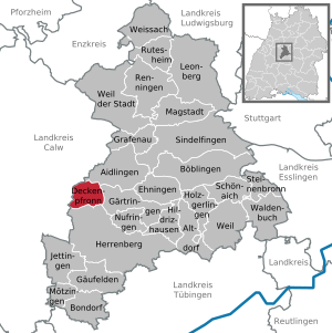
| Location of the community of ceiling Pfronn in the district of Böblingen | ||
  |
||

Blanket Pfronn is one of a total of 26 and - in terms of population - the smallest municipality in the Böblingen district in Baden-Württemberg . It belongs to the Stuttgart region (until 1992 the Middle Neckar region ) as well as to the fringe of the European metropolitan region of Stuttgart and is located in the western part of the district on the border with the Calw district . Tennental belongs to the village of Bettenpfronn.
geography
Geographical location
Ceiling Pfronn lies on a flat, undulating plateau in the transition area between the Heckengäu and the Korngäu or between the administrative districts of Stuttgart and Karlsruhe , seven kilometers northwest of Herrenberg and ten kilometers southeast of Calw . The place is connected to the long-distance traffic network by the B296 as well as state and district roads. The " Gärtringen junction " of the A 81 , five kilometers away, can be reached in 10 minutes by car. The public transport is carried out by bus lines of the Verkehrs- und Tarifverbund Stuttgart (VVS) . The northern Black Forest begins to the west of the village . Naturally, it belongs to the higher-level unit of the Upper Gau . The highest point is at 599.27 m in the northwest, the lowest point west of the village at 499.56 m.
Neighboring communities
Ceiling Pfronn has a total of six neighboring communities: Aidlingen , Gärtringen , Herrenberg ( Boeblingen district ), Wildberg , Calw and Gechingen ( Calw district ).
geology
From a geological point of view, ceiling Pfronn is located on the watershed between the Nagold in the west and the Würm in the east, which enters the district in the upper forest to the southwest of ceiling Pfronn. The fertile loess soils merge into the hedge and heather landscape and consist of the weathering of the main mussel limestone , the mussel limestone dolomite and the Letten coal marl . The red sandstone connects to the west.
history

Early historical development
It is certain that people lived in the area of the municipality as early as 3500 years ago. Ceiling Pfronn was called "Teckenprun" as early as 830 as a property of the Hirsau monastery . "Deggenphrum" is officially mentioned for the first time in a certificate from Count Adalbert II of Calw, confirmed by Emperor Heinrich IV on October 9, 1075, about the renewal of the donation of goods in ceiling Pfronn to the Hirsau monastery. The document standing at the end of the so-called investiture dispute between church and state is the " Hirsau Form " which has become significant for world historical development . In it the place "Deggenphrum" was called "Teckenphron" under the local nobility in the 13th century, since 1260 "Tekkenphrunde", since 1342 "ceiling Pfrond". In 1388 ceiling Pfronn came to Württemberg . From 1850 the current name "ceiling Pfronn" was introduced.
The interpretation "deanery benefice" is considered to be the most probable, because ceiling Pfronn has always belonged to the deanery Calw and the camera office Calw was responsible for the collection of the tithe . Derived names from "Dego" and "Veronika" (Frun, Fron, Fro) have not been confirmed.
Over the centuries, a densely built-up town center developed, as is typical and characteristic of the old settlements . On the narrow main street there were mostly plastered half-timbered houses with gable roofs . Behind it were stables and barns, followed by the village gardens. The fortified church with the Nikolauskirche at today's place, the "Schlössle" (today's cemetery), later the schoolhouse and the Widembauernhaus formed the center of the early village.
Around the year 1300 the place has about 300 inhabitants. After the plague had made the place almost deserted in 1348, the Thirty Years' War caused a catastrophe for the second time. The recovery took a long time and it was not until the beginning of the 18th century that the town in the Calw district developed as a "respectable spot" into a recognized cattle breeding community and the rural cohesion was very much consolidated.
19th century
In 1818 the Nikolauskirche was rebuilt. The burial ground on the north side of the church was expanded in 1840. The old town hall with a turret and bell on the ridge was rebuilt in 1829 and bought by the municipality for 5000 guilders in 1842. The schoolhouse, which was significantly improved in the years 1829 and 1842, contained 3 classrooms as well as the apartments of the schoolmaster, the assistant teacher and the school assistant, as well as the sheepfold on the lower floor. The community had a public wash house built on the site of the previous one in 1824. Almost every farmer was only able to support his family with a handcraft surplus. Around 1850 there were 23 bread bakers in ceiling Pfronn who only baked once a week, 9 blacksmiths, 27 shoemakers, 36 bricklayers and many clapboard makers who offered the roof sealing material obtained from the local forest in the cities.
20th century
At the beginning of the 20th century, ceiling planks shaped a number of fundamental innovations, including the construction of the first public water pipeline, the introduction of electricity and the establishment of the dairy cooperative. At that time, the driving force was the active mayor Christian Luz.
Shortly before the end of the Second World War , on the morning of April 21, 1945, there was an air raid with 14 fighter bombers on ceiling planks, 70% of the place being destroyed by high explosive and incendiary bombs, including all public facilities such as the Nikolauskirche, the town hall and the school , the barn and the dairy. The old, closely spaced half-timbered houses could hardly withstand the firestorm. A total of 160 buildings burned down. Only the main part of the village, the old rectory and some buildings on the outskirts escaped the disaster. 11 people died in the attack and over 600 people were left homeless. As a result, people lived for a number of years in the narrowest living conditions in the remaining village, in the former RAD camp or in the buildings of the nearby Lerchenberg .
The housing shortage encouraged the rapid start of reconstruction planning in autumn 1945 and the draft of the site plan, which was formally established in 1951, was already in place in 1946. In the process, the Liebenzell architect Hermann Hornbacher , who was influenced by the ideas of the famous Paul Bonatz , became the master builder of the reconstruction in collaboration with Surveyor Charrier. The first buildings were moved into as early as 1948, almost all of which were half-timbered. Its design followed the ideas of the " Stuttgarter Schule " architectural model taught at the University of Stuttgart and those of Heimatschutz architecture of the 1920s and 1930s. The principle of "loosened development" with plots of around 10 ares was popular, but led to disputes that were hardly manageable. Everyone wanted to be where they used to be, but the small plots didn't make that possible. 22 hectares had to be planned over in order to meet the new goals. "Fierce discussions about the inclusion of land in the building land environment, about the allocation of building sites and streets, about the position and type of buildings cost strength and nerves. The financing caused great sorrow and hardly anyone believes that he could ever be happy again", so the comment of the then incumbent mayor Ulrich.
With the "loosened reconstruction", the parcels were enlarged, all of which were now directly accessible from the street. The agricultural properties were relocated to the new parallel streets in the north and south, which were given sustainable functionality. The central traffic structure was retained; the once narrow main street has been widened, straightened and expanded to create an urban marketplace, where the three annual markets are once again held. This was reserved for residential and commercial buildings.
The reconstruction of the private property, which was initially driven forward and completed in 1951, was supported by loans. The public buildings were subsidized up to 90% by the state. In 1953 the church was re-consecrated and the town hall was rebuilt at the so-called "Schmiedspitze" at the top of Marktstrasse. With a big home day and pageant, the reconstruction of ceiling planks was finally officially completed on Pentecost 1957.
The further development of the area has mainly shaped the younger generation. Young families who no longer wanted to stay at home looked for new living space. As early as 1960, the local council dared to go to the countless allotment gardens in Brühl with a total area of 8 hectares and to designate new building land there. New, large-scale settlement areas emerged up to the mid-1960s, mainly in the south and north of the municipality. In connection with land consolidation , a number of repatriate farms were built around the village in 1965 . Since 1966, further building areas have been continuously developed on the south-western and south-eastern outskirts, e.g. B. 1971 the area "Osterbuckel", 1972, 1976, 1983 and 1993 the residential areas in "Angel", in "Frontal", in "Kampfäcker" and at "Gärtringer Weg" and most recently in 2008 the residential area "Lüsse" with 7 hectares towards Gärtringen . A closed industrial area has existed on the B296 since 1980 .
The number and infrastructure of the public facilities were also able to withstand the rapid structural change adequately: In the course of a comprehensive renovation of the town center and after the supply and disposal facilities had been secured, the building of a separate sewage treatment plant and the contemporary design of illuminated streets and squares, the primary school was rebuilt several times, a new kindergarten was built and the fire brigade received a future-oriented house in the industrial area. After the 1980 inaugurated community hall also was in 1987 Zehntscheuer the town house rebuilt.
On July 19, 1953, the church was consecrated again and finally, in 1957, the reconstruction of the place was officially completed. In connection with land consolidation , a number of repatriate farms were built around the village in 1965 . New framework conditions for agriculture were established. Local farmers found better opportunities to earn money from businesses like "Warmth and Cold Dongus". Since 1966, new building areas have been continuously designated, most recently in 2008 the residential area "Lüsse" in the direction of Gärtringen .
Up to December 31, 1972, ceiling Pfronn belonged to the district of Calw . Today it is the smallest independent municipality in the Boeblingen district .
Religions
The Reformation was introduced in ceiling Pfronn in 1535 , the last Catholic priest Martin Yelin became the first Protestant pastor. The approximately 1,800 Protestant Christians belong to the local "Evangelical Church Congregation ceilingpfronn", the Catholics to the Catholic Church Congregation "St. Antonius Herrenberg- Kuppingen ".
.jpg)
Population development
- 1440: 48 families
- 1621: 488 inhabitants
- 1653: 355 inhabitants
- 1661: 333 inhabitants
- 1676: 428 inhabitants
- 1684: 415 inhabitants
- 1700: 421 inhabitants
- 1711: 490 inhabitants
- 1721: 514 inhabitants
- 1731: 503 inhabitants
- 1741: 535 inhabitants
- 1763: 635 inhabitants
- 1783: 707 inhabitants
- 1800: 829 inhabitants
- 1811: 970 inhabitants
- 1816: 1018 inhabitants
- 1831: 1216 inhabitants
- 1832: 1178 inhabitants
- 1841: 1271 inhabitants
- 1851: 1351 inhabitants
- 1852: 1111 inhabitants
- 1860: 1178 inhabitants
- 1861: 1240 inhabitants
- 1871: 1162 inhabitants
- 1875: 1118 inhabitants
- 1880: 1202 inhabitants
- 1890: 1193 inhabitants
- 1900: 1178 inhabitants
- 1910: 1132 inhabitants
- 1925: 1087 inhabitants
- 1933: 1084 inhabitants
- 1939: 1071 inhabitants
- 1950: 1003 inhabitants
- 1954: 1110 inhabitants
- 1955: 1142 inhabitants
- 1956: 1187 inhabitants
- 1961: 1224 inhabitants
- 1966: 1334 inhabitants
- 1970: 1504 inhabitants
- 1987: 2074 inhabitants
- 1990: 2231 inhabitants
- 1991: 2329 inhabitants
- 1995: 2416 inhabitants
- 2001: 2785 inhabitants
- 2004: 2907 inhabitants
- 2005: 2929 inhabitants
- 2006: 2958 inhabitants
- 2008: 3034 inhabitants
- 2009: 2974 inhabitants
- 2010: 3168 inhabitants
- 2011: 3208 inhabitants
- 2013: 3269 inhabitants
- 2014: 3269 inhabitants
- 2015: 3284 inhabitants
- 2016: 3269 inhabitants
- 2018: 3329 inhabitants
- 2019: 3338 inhabitants
politics
Municipal council
The local elections on May 26, 2019 led to the following result. The municipal council consists of the elected voluntary councilors and the mayor as chairman. The mayor is entitled to vote in the municipal council. The turnout was 69.44% (2014: 60.6%).
- List of Independent Citizens: 51.46%, 6 seats (2014: 5 seats)
- Free electoral association: 48.54%, 6 seats (2014: 7 seats)
mayor
In the mayoral election on April 5, 2009, Daniel Gött (born 1981, independent) prevailed against his formal competitor Bärbel Sauer with 87.47 percent of the valid votes cast and a turnout of 68.99 percent. He became the successor to Winfried Kuppler, who retired on July 4th, 2009 after 39 years. Gött was re-elected in April 2017.
Coat of arms
In the coat of arms a green fir branch lying to the left has been shown under the golden yellow shield head since 1948 as a symbol of belonging to the Black Forest . Below that, on a green background, is a golden yellow abbot's crosier rising from the lower edge, turned to the left, which has been documented on landmarks since 1681 and indicates that the income from goods in the district ceiling Pfronn has belonged to Hirsau monastery since the 9th century . The two ears of wheat shown on the side , formerly spelled and now wheat , symbolize belonging to the Upper Gäu and its fertile loess soils .
Partnerships
Since 1990 there has been a community friendship with Weißenberg in Upper Lusatia in Saxony .
Educational institutions
- Gottlob Ernst Primary School
- Adult Education Center in ceiling Pfronn as a branch of the Adult Education Center in Herrenberg
- Technical school for curative care in the Tennental village community, Tennentaler Communities e. V.
Tennental
In the direction of Gärtringen , in the middle of the field, is the village community "Tennental", which belongs to ceiling Pfronn. This is a facility for the disabled based on the anthroposophical model with a curative education nursing school (see above).
Culture and sights
The town hall is located directly on the market square. It is characterized by a massive ground floor (bricks made of frugal bricks), a half-timbered upper floor and typical building details such as asymmetrical bay windows , an entrance arbor and a bell tower on the roof.
The Zehntscheuer at Herrenberger Str. 23 is at the same time a community center, local museum and event location for cabaret . The “Hot-Cold” museum was opened in the Pfarrscheuer (Berghütte 9) in 2009, which, under the direction of the “Kulturwerkstatt ceilingpfronn” association, presents exhibits from local history.
The radio station Lerchenberg of the state police headquarters in Karlsruhe, which also includes an 81-meter-high telecommunications tower , is located north of ceiling Pfronn on the Lerchenberg , which belongs to Validlingen .
An interesting excursion destination is the glider-flying site in ceilingpfronn-Egelsee , southwest of ceiling Pfronn on the federal highway 296 , where glider pilots take off on their flights over the Black Forest and the Swabian Alb on the weekends when the weather is good .

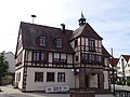
town hall


Honorary citizen
- Winfried Kuppler (Mayor from 1969 to 2009)
literature
- Barbara Baum, Martin Hahn: Ceiling Pfronn - a village is being rebuilt . State Office for Monument Preservation, 2006 ( PDF )
Web links
Individual evidence
- ↑ State Statistical Office Baden-Württemberg - Population by nationality and gender on December 31, 2018 (CSV file) ( help on this ).
- ↑ Ceiling Pfronn - detail page - LEO-BW. Retrieved March 27, 2020 .
- ↑ Page: OberamtCalw 007.jpg - Wikisource. Retrieved March 27, 2020 .
- ↑ Description of the Oberamt Calw / Chapter B 10 - Wikisource. Retrieved March 27, 2020 .
- ↑ State Gazette No. 13 of April 9, 2009, page 11
- ↑ http://www.stuttgarter-nachrichten.de/inhalt.buergermeister-in-habenpfronn-daniel-goett-ist-wiedergewaehlt.df9df8e0-73cf-4c8a-871f-9d2742059064.html
- ^ Municipality of ceiling Pfronn: The historical coat of arms. In: ceilingpfronn.de. Municipality of ceilingpfronn, accessed on March 27, 2020 (German).
- ↑ Ceiling Pfronn - detail page - LEO-BW. Retrieved March 27, 2020 .

Aidlingen | Altdorf | Boeblingen | Bondorf | Ceiling plank | Ehningen | Garden rings | Gäufelden | Grafenau | Herrenberg | Hildrizhausen | Holzgerlingen | Jettingen | Leonberg | Magstadt | Mötzingen | Nufringen | Renningen | Rutesheim | Schönaich | Sindelfingen | Steinenbronn | Waldenbuch | Because the city | Because in the beautiful book | Weissach