
Weissenberg
| coat of arms | Germany map | |
|---|---|---|
.png)
|
Coordinates: 51 ° 12 ' N , 14 ° 40' E |
|
| Basic data | ||
| State : | Saxony | |
| County : | Bautzen | |
| Height : | 197 m above sea level NHN | |
| Area : | 50.96 km 2 | |
| Residents: | 3096 (Dec. 31, 2019) | |
| Population density : | 61 inhabitants per km 2 | |
| Postal code : | 02627 | |
| Primaries : | 035876, 035939 (Belgern, Drehsa, Wurschen) | |
| License plate : | BZ, BIW, HY, KM | |
| Community key : | 14 6 25 610 | |
| City structure: | 15 districts | |
City administration address : |
August-Bebel-Strasse 1 02627 Weissenberg |
|
| Website : | ||
| Mayor : | Jürgen Arlt (independent) | |
| Location of the city of Weißenberg in the Bautzen district | ||
  |
||

Weißenberg , in Sorbian , is a country town in the Saxon district of Bautzen in Upper Lusatia . The actual city has about 1000 inhabitants, with the surrounding villages there are about 3200. Weißenberg is part of the official Sorbian settlement area .

geography
Weißenberg is located about 16 km east of the large district town of Bautzen north of the Strohmberg on Löbauer Wasser .
The city is bordered by Malschwitz and Hohendubrau in the north, Vierkirchen in the east, Löbau in the southeast, Hochkirch in the southwest and Kubschütz in the west.
City structure / districts


- Belgians (Sorbian Běła Hora , that actually means "White Mountain"), 88 inhabitants
- Cortnitz (Chortnica) , 42 inhabitants
- Drehsa (Droždźij) , 234 inhabitants
- Gröditz (Hrodźišćo) , 246 inhabitants
- Pit (Jama) , 27 inhabitants
- Kotitz (Kotecy) , 193 inhabitants
- Lauske (Łusk) , 139 inhabitants
- Maltitz (Malećicy) with water ketcham (Wodowa korčma) , 265 inhabitants
- Nechern (Njechorń) , 123 inhabitants
- Nostitz (Nosaćicy) , 174 inhabitants
- Särka (Žarki) , 166 inhabitants
- Spittel (Špikały) , 53 inhabitants
- Weicha (Wichowy) , 98 inhabitants
- Weißenberg, 977 inhabitants
- Wuischke (Wuježk) , 35 residents
- Wurschen (Worcyn) , 312 inhabitants
history

The founding of the city of Weißenberg on the Via Regia goes back to the Bohemian King Ottokar I around 1228. The name at that time was Wizenburg and referred to the town's white castle.
In 1625 the town was able to buy itself out of its noble lord for 8,500 thalers. The city still had to accept a knightly patron.
As recently as the 18th century, Weißenberg was mentioned as a largely Sorbian-inhabited market town, and all of the residents were also able to speak German. Arnošt Muka determined a population of 1242 in the 1880s, including 300 Sorbs (24%) at that time . In 1956 Ernst Tschernik counted a Sorbian-speaking population of only 5.8%, a total of 81 speakers.
The current district of Wurschen is immortalized on the triumphal arch in Paris , as the battle of Bautzen on May 20 and 21, 1813 in France is sometimes called Bataille de Wurschen .
On April 17, 1945, the fighting of the Second World War came to Weissenberg for the first time when Soviet artillery attacked the city's train station. The next day, Weissenberg was occupied by Soviet troops.
politics

City council
Since the municipal council election on May 26, 2019 , the 14 seats of the city council have been distributed among the individual groups as follows:
- Weissenberg voters' association (WV W): 9 seats
- CDU : 5 seats
Michael Staude retired after 32 years of service. In June 2015, Jürgen Arlt was elected as his successor in the second ballot.
Town twinning
Weißenberg maintains a partnership with the community of Bettenpfronn in the district of Böblingen on the edge of the Black Forest .
Attractions

- Castle Drehsa
- Kotitz: Evangelical church with Jan Kilian monument
- Lauske: Castle garden with jump tower
- Bar mill in Nechern
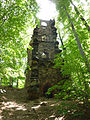
- Church, castle ruins and manor in Nostitz
- The Alte Pfefferküchlerei museum in Weißenberg shows traditional gingerbread production
- Wurschen Castle
Jump tower in Lauske

Bar mill in Nechern
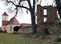
Church and castle ruins in Nostitz
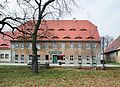
Manor house of the manor in Nostitz

Wurschen Castle


_Schlo%C3%9Fruine_Turm.jpg)
_Rittergut_Herrenhaus.jpg)

education
The community of Weißenberg has a primary school. There is also a free secondary school in the village.

traffic
The station Weissenberg (Sachs) was on the railway line Löbau-Radibor . The station Weissenberg (Sachs) Süd lay on the railway Görlitz White Mountain . Both railway lines are closed .
Personalities
sons and daughters of the town
- Alfred zu Solms-Sonnenwalde (1810–1870), Prussian nobleman and politician, born in Kotitz
- Viktor Christian Konstantin von Solms-Sonnenwalde (1815–1890), Prussian district administrator, born in Kotitz
- Ernst von Heynitz (1840–1912), landowner, legal knight of the Order of St. John , farmer, organizer of the nursing care of the Schutztruppe in German South West Africa , born on the local estate
- Ellie von Bleichröder (1894–1989), granddaughter of the banker Baron Gerson von Bleichröder and a prominent inmate of the Theresienstadt concentration camp , was born in Drehsa
- Měrćin Nowak-Njechorński (1900–1990), Sorbian painter, graphic artist, publicist and writer
- Pawoł Nedo , German Paul Nedo (1908–1984), Sorbian educator and ethnologist, chairman of the Domowina
People related to the city
- Jan Kilian (1811–1884), pastor in Kotitz and leader of over 500 Sorbian emigrants
- Benno von Heynitz (1924–2010), resistance fighter and lawyer, initiator of the Bautzen-Komitee e. V. and the Bautzen Memorial
literature
- Cornelius Gurlitt : Weissenberg. In: Descriptive representation of the older architectural and art monuments of the Kingdom of Saxony. 34. Issue: Official Authority Löbau . CC Meinhold, Dresden 1910, p. 577.
- Weissenberg. Pictures tell , Horb am Neckar 1994
Web links
- Weißenberg in the Digital Historical Directory of Saxony
- Web presence of the city of Weißenberg
- Photographs from Weißenberg
- Interactive 360 ° panorama of Weißenberg, market square
Individual evidence
- ↑ Population of the Free State of Saxony by municipalities on December 31, 2019 ( help on this ).
- ↑ Annex (to Section 3, Paragraph 2) of the Saxon Sorbs Act
- ^ Information from the Weißenberg city administration; As of December 31, 2016.
- ^ Jan Meschgang: The place names of Upper Lusatia. Domowina Verlag, Bautzen 1973, p. 144.
- ^ Richard Andree: Wendish wandering studies. Stuttgart 1874, p. 59
- ↑ Ernst Tschernik: The development of the Sorbian population . Akademie-Verlag, Berlin 1954, p. 108 .
- ^ Ludwig Elle: Language policy in the Lausitz . Domowina-Verlag, Bautzen 1995, p. 246 .
- ↑ Bautzener Tageblatt of May 2, 1945, report on the fighting for Bautzen
- ↑ Results of the 2019 municipal council elections
- ↑ http://www.gaeubote.de/index.php?&kat=10&artikel=110925998&red=24&ausgabe=69131
- ↑ http://www.ghetto-theresienstadt.info/pages/b/bleichroeder.htm ( page no longer available , search in web archives ) Info: The link was automatically marked as defective. Please check the link according to the instructions and then remove this notice.

Cities:
Bautzen (Budyšin) |
Bernsdorf (Upper Lusatia) |
Bischofswerda |
Elstra (Halštrow) |
Großröhrsdorf |
Hoyerswerda (Wojerecy) |
Kamenz (Kamjenc) |
Koenigsbrück |
Lauta |
Pulsnitz |
Radeberg |
Schirgiswalde-Kirschau |
Weißenberg (Wóspork) |
Wilthen |
Wittichenau (Kulow)
Municipalities:
Arnsdorf |
Burkau (Porchow) |
Crostwitz (Chrósćicy) |
Cunewalde |
Demitz-Thumitz |
Doberschau Gaussig (Dobruša Huska) |
Elsterheide (Halštrowska hola) |
Frankenthal |
Göda (Hodźij) |
Großdubrau (Wulka Dubrawa) |
Großharthau |
Großnaundorf |
Großpostwitz / OL (Budestecy) |
Haselbachtal |
Hochkirch (Bukecy) |
Königswartha (Rakecy) |
Kubschütz (Kubšicy) |
Laußnitz |
Lichtenberg |
Lohsa (Łaz) |
Malschwitz (Malešecy) |
Nebelschütz (Njebjelčicy) |
Neschwitz (Njeswačidło) |
Neukirch |
Neukirch / Lausitz |
Obergurig (Hornja Hórka) |
Ohorn |
Oßling (Wóslink) |
Ottendorf-Okrilla |
Panschwitz-Kuckau (Pančicy-Kukow) |
Puschwitz (Bóšicy) |
Räckelwitz (Worklecy) |
Radibor (Radwor) |
Ralbitz-Rosenthal (Ralbicy-Róžant) |
Rammenau |
Schmölln-Putzkau |
Schwepnitz |
Sohland on the Spree |
Spreetal (Sprjewiny Doł) |
Steina |
Steinigtwolmsdorf |
Wachau (Saxony)