
Vierkirchen (Upper Lusatia)
| coat of arms | Germany map | |
|---|---|---|

|
Coordinates: 51 ° 12 ' N , 14 ° 46' E |
|
| Basic data | ||
| State : | Saxony | |
| County : | Goerlitz | |
| Management Community : | Reichenbach / OL | |
| Height : | 192 m above sea level NHN | |
| Area : | 35.41 km 2 | |
| Residents: | 1663 (Dec. 31, 2019) | |
| Population density : | 47 inhabitants per km 2 | |
| Postal code : | 02894 | |
| Area code : | 035827 | |
| License plate : | GR, LÖB, NOL, NY, WSW, ZI | |
| Community key : | 14 6 26 570 | |
| Community structure: | 10 districts | |
| Association administration address: | Görlitzer Strasse 4 02894 Reichenbach / OL |
|
| Website : | ||
| Mayoress : | Andrea Weise | |
| Location of the municipality of Vierkirchen in the district of Görlitz | ||
  |
||

Vierkirchen is a Saxon municipality in the district of Görlitz . The community belongs to the administrative community Reichenbach / OL .
Geography and traffic
The municipality of Vierkirchen is located in the mid-west of the district, around 15 km east of Bautzen and around 10 km northwest of the administrative center of Reichenbach / OL . The federal highway 6 runs south of the municipality, the federal highway 4 leads directly through the municipality and can be reached via the connections Weißenberg or Nieder Seifersdorf .
Neighboring communities are clockwise from north to west: Hohendubrau , Waldhufen , Königshain , Reichenbach , Löbau and Weißenberg ( district of Bautzen ).
history
The municipality of Vierkirchen was formed on January 1, 1994 from the municipalities of Arnsdorf-Hilbersdorf , Buchholz and Melaune as part of the Saxon municipality reform. The four churches of Arnsdorf, Buchholz, Melaune and Tetta were named here; these four churches also appear in the municipality's coat of arms. Since its inception, the community has been part of the Reichenbach administrative community.
In the Arnsdorf district there is a granite quarrying company that has been run for generations . The Arnsdorf granite stock was created in the carbon and is still being mined today. Here the material for the Berlin Olympic Stadium , the congress hall in Nuremberg and the Comecon building in Moscow was obtained.
Population development
| year | Residents | |||
|---|---|---|---|---|
| Arnsdorf- Hilbersdorf |
Buchholz | Melaune | total or four churches |
|
| 1990 | 746 | 552 | 755 | 2053 |
| 1993 | 722 | 562 | 715 | 1999 |
| 1999 | - | - | - | 2066 |
| 2006 | - | - | - | 1958 |
| 2009 | - | - | - | 1842 |
| 2012 | - | - | - | 1732 |
| 2013 | - | - | - | 1704 |
Local partnerships
Vierkirchen maintains a local partnership with the Polish Jeżów Sudecki ( Grunau ).
Local division
Districts are:
|
|
politics
Since the municipal council election on May 26, 2019 , the 12 seats of the municipal council have been distributed among the individual groups as follows:
- Free electoral association Arnsdorf-Hilbersdorf (FWV): 5 seats
- Active voter association Döbschütz / Melaune / Prachenau (AWV): 4 seats
- Voting Association Buchholz / Tetta (WV BT): 3 seats
Attractions
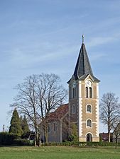
- four village churches
- St. Katharinen Church Arnsdorf
- Döbschütz Castle
- Another attraction is an imposing ground monument on the banks of the Schwarzen Schöps : It is a presumably Slavic section wall that is occasionally referred to as "Merburg". Excavations took place in the 1920s. The association “Die Milzener eV” takes care of maintenance and mediation in Melaune , and is planning an open-air museum for early Slavic history together with the University of Jena , Department of Prehistory and Early History.
- Ice rink for winter and summer sports
- Football stadium
- playground
- The Way of St. James in the Görlitz-Weißenberg-Bautzen section runs through Arnsdorf, Döbschütz, Melaune, Tetta and Buchholz.
The cultural monuments are recorded in the list of cultural monuments in Vierkirchen (Oberlausitz) .
- The eponymous churches of the parish

Arnsdorf

Buchholz

Melaune
Tetta


Web links
- Vierkirchen community
- Vierkirchen in the Digital Historical Directory of Saxony
Individual evidence
- ↑ Population of the Free State of Saxony by municipalities on December 31, 2019 ( help on this ).
- ^ Predecessor Horst Brückner, who was also mayor of the neighboring community of Waldhufen , was the only candidate in 2008. This double position was no longer possible in 2015, but there were no candidates in the first two ballots, so that the voters mostly wrote his name on the empty ballot paper. In the third ballot in February 2016 there were then two candidates, cf. Vierkirchen has a mayor. In: Saxon newspaper . February 15, 2016, accessed April 13, 2020 .
- ↑ Results of the 2019 municipal council elections

Bad Muskau (Mužakow) | Beiersdorf | Bernstadt ad Eigen | Bertsdorf-Hörnitz | Boxberg / OL (Hamor) | Dürrhennersdorf | Ebersbach-Neugersdorf | Gablenz (Jabłońc) | Goerlitz | Groß Düben (Dźěwin) | Großschönau | Großschweidnitz | Chickens | Hainewalde | Herrnhut | Hohendubrau (Wysoka Dubrawa) | Horka | Jonsdorf | Kodersdorf | Königshain | Kottmar | Krauschwitz (Krušwica) | Kreba-Neudorf (Chrjebja-Nowa Wjes) | Lawalde | Leutersdorf | Löbau | Markersdorf | Mittelherwigsdorf | Mücka (Mikow) | Neißeaue | Neusalza-Spremberg | Niesky | Oderwitz | Olbersdorf | Oppach | Ostritz | Oybin | Quitzdorf am See | Reichenbach / OL | Rietschen (Rěčicy) | Rosenbach | Rothenburg / OL | Loop (slepo) | Schönau-Berzdorf ad Eigen | Schönbach | Schöpstal | Seifhennersdorf | Trebendorf (Trjebin) | Vierkirchen | Forest hooves | White chisel (Wuskidź) | White water (Běła Woda) | Zittau