
Arnsdorf (Vierkirchen)
|
Arnsdorf
Community Vierkirchen
Coordinates: 51 ° 11 ′ 45 ″ N , 14 ° 46 ′ 50 ″ E
|
|
|---|---|
| Height : | 196 m |
| Area : | 7.3 km² |
| Residents : | 493 (December 31, 2011) |
| Population density : | 68 inhabitants / km² |
| Incorporation : | January 1, 1970 |
| Incorporated into: | Arnsdorf-Hilbersdorf |
| Postal code : | 02894 |
| Area code : | 035827 |
Arnsdorf is one of ten districts of the municipality Vierkirchen in the Saxon district of Görlitz . Arnsdorf has around 500 inhabitants and covers an area of 7.3 km². This corresponds to a population density of 68 inhabitants per km².
geography
Arnsdorf is located in the eastern part of the municipality of Vierkirchen, south of the federal motorway 4 . Hilbersdorf is located south of Arnsdorf , the Reichenbacher districts of Dittmannsdorf and Krobnitz are in the southwest and Melaune in the west . To the north, on the other side of the motorway, lies the Waldhufen district of Nieder Seifersdorf , after which the motorway junction, two kilometers away, is named.
history

Place name
The name Arnsdorf means village of an Arnolds . It is believed that the village may have been named after Arnold von Radeberg. The Sorbian name Warnołcicy , which is identical to that of Arnsdorf near Ruhland , is no longer used today.
Local history
The first documentary mention of Arnsdorf was in 1366 in the Görlitz city register as Arnoldisdorf . The village is probably much older as the church probably dates from the first half of the 13th century.
Arnsdorf had already developed into an estate village with two estate shares at the beginning of the 15th century. Hans von Gersdorff auf Döbschütz was able to acquire the two parts between 1531 and 1536. The Reformation took place at the same time. There were first attempts as early as 1525; the first known Protestant pastor was ordained in 1549. In 1582, the ceiling painting in the nave was designed as it can still be seen today. There was evidence of a school just three years later.
Renovations to the church, which began in the 15th century and continued into the 18th century, gave the church its present-day appearance. A Dutch windmill was built above the church in 1835 and operated for around a century.
Hilbersdorf came under the rule of Arnsdorf as early as the end of the 18th century . The two villages were to remain together as a manorial until the land reform after the Second World War .
Since 1850 there has been a rapid development of the stone industry, which resulted in the creation of several large quarries . The colourfast granite was used throughout Germany.
Since 1970 Arnsdorf and Hilbersdorf formed the municipality of Arnsdorf-Hilbersdorf . In the same year, the still active quarries in both parts of the community were closed. The Görlitzer Kreisbahn , which had also passed through Arnsdorf since 1904, was discontinued in 1972. After the fall of the Wall , granite mining resumed.
The communities of Arnsdorf-Hilbersdorf, Buchholz and Melaune, which were affected by population decline, merged on January 1, 1994 to form the community of Vierkirchen.
In the school, built in 1789, a day care center was set up on August 1, 2002 .
Population development
| year | Residents |
|---|---|
| 1825 | 559 |
| 1871 | 662 |
| 1885 | 691 |
| 1905 | 685 |
| 1925 | 667 |
| 1939 | 624 |
| 1946 | 824 |
| 1950 | 791 |
| 1964 | 679 |
| 2002 | 502 |
| 2003 | 494 |
| 2008 | 464 |
| 2011 | 493 |
In 1529, seven possessed men ran in Arnsdorf . In 1777 there were eight possessed men, 30 gardeners and 25 cottagers .
In the 19th century the population increased from around 550 to just under 700. After that, it fell continuously to 624 until the outbreak of World War II. Due to refugees and displaced persons from the former German eastern areas, the number rose to over 800 after the war, but could not be maintained.
At the beginning of the 21st century, the population was around 500, below the number recorded two centuries earlier. In the second decade of the 21st century, however, the population increases again.
Attractions
- Baroque palace with old palace gardening from 1856
- Church of St. Catherine from the 13th century
- two stone crosses at the entrance and near the churchyard
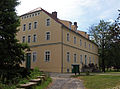
lock
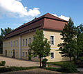
Orangery in the castle park
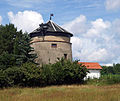
Windmill
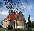
Church of St. Catherine
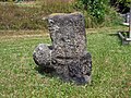
Stone cross


Transport links
- Bundesautobahn 4 : Nieder Seifersdorf exit
- Regional bus Oberlausitz : Bus route 145 (Görlitz – Weißenberg)
Personalities
- Karl von Wiedebach and Nostitz-Jänkendorf (1844–1910), politicians, member of the Prussian manor house
- Paul von Wiedebach and Nostitz-Jänkendorf (1848–1923), politicians, member of the Prussian manor house
- Hans Schranz (1916–1987), Swiss writer
literature
- From the Muskauer Heide to the Rotstein. Home book of the Lower Silesian Upper Lusatia District . Lusatia Verlag, Bautzen 2006, p. 345 f.
- Hans-Georg Walther, Vierkirchen community (ed.): Mei Dörfel . Niesky 1996.
Web links
- Arnsdorf in the Digital Historical Directory of Saxony
- Community website
- Arnsdorf granite stock
Individual evidence
- ↑ according to the website of the municipality of Vierkirchen: 493 on December 31, 2011
- ↑ Digital historical place directory of Saxony. Retrieved June 24, 2008 .
- ↑ Von der Muskauer Heide zum Rotstein , p. 345
- ^ Vierkirchen.com: The village of Arnsdorf. Retrieved April 27, 2009 .
- ^ Vierkirchen.com: The village of Arnsdorf. Retrieved August 24, 2012 .
- ↑ Hans-Georg Walther, Vierkirchen community (ed.): Mei Dörfel . Niesky 1996, p. 59.

Arnsdorf | Buchholz | Döbschütz | Heideberg | Hilbersdorf | Melaune | Prachenau | Red secretscham | Tetta | Water ketcham