
Ostritz
| coat of arms | Germany map | |
|---|---|---|

|
Coordinates: 51 ° 1 ′ N , 14 ° 56 ′ E |
|
| Basic data | ||
| State : | Saxony | |
| County : | Goerlitz | |
| Height : | 207 m above sea level NHN | |
| Area : | 23.48 km 2 | |
| Residents: | 2241 (Dec. 31, 2019) | |
| Population density : | 95 inhabitants per km 2 | |
| Postal code : | 02899 | |
| Area code : | 035823 | |
| License plate : | GR, LÖB, NOL, NY, WSW, ZI | |
| Community key : | 14 6 26 420 | |
| LOCODE : | DE O2Z | |
City administration address : |
Markt 1 02899 Ostritz |
|
| Website : | ||
| Mayoress : | Marion Prange (independent) | |
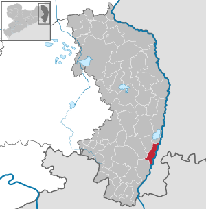
| Location of the city of Ostritz in the district of Görlitz | ||
  |
||

Ostritz ( Upper Lusatian : Usterz , Upper Sorbian Wostrowc ) is a Saxon country town in the district of Görlitz in Upper Lusatia . Ostritz is located in the far east of Saxony on the western bank of the Neisse, right on the border with the Polish urban and rural community of Bogatynia .

geography
Geographical location
The urban area extends along the western bank of the Lusatian Neisse in the natural area of Eastern Upper Lusatia . From north to south follow one another: Leuba , the actual city of Ostritz (the area of the medieval German city foundation); the old town (the former Sorbian village (formerly Alt-Ostritz)), and in the far south the St. Marienthal monastery with its upstream settlement.
history
The first settlement around 500 AD was a simple Slavic village, with huts made of wood and clay, which had the shape of a not completely closed round . It was on a branch of the Neisse, on the old road to Friedland . There was only one ford through the Neisse, there was no bridge at that time.
Ostritz was possibly first mentioned in 1007 as castellum Ostrusna , but the name can also refer to other fortifications, such as the Rotstein near Sohland . The name goes back to the Old Sorbian word Ostrožn - Ostrog Pfahl and denotes a settlement surrounded by palisades.
The rule of Ostritz passed from the Bohemian King to the Burgraves of Dohna at Grafenstein Castle around 1230 . The first owner of the Ostritz estate was probably burgrave Otto I. von Dohna, who is mentioned in 1206 and 1239. His daughter Adelheid von Dohna († before 1267) was the first abbess of the Cistercian convent of St. Marienthal, founded in 1234.
Incorporations
In 1933 the old town (formerly Alt-Ostritz ) was incorporated into the city. The village of St. Marienthal followed on July 1, 1950. The municipality of Leuba was incorporated into the city of Ostritz on January 1, 1994.
politics
Municipal council
Since the city council election on May 26, 2019 , the 12 seats of the city council have been distributed among the individual parties and groups as follows:

| Independent citizens for Ostritz and Leuba (UB) | 6 seats | |
| CDU | 3 seats | |
| AfD | 1 seat | |
| Unorganized voter association settlement (NWS) | 1 seat | |
| FDP | 1 seat |
mayor
Marion Prange has been mayor since August 1st, 2008, she prevailed against a competitor with 80.46%. Her predecessor, Friedrich Tschirner, did not run for the election in June 2008.
Ms. Prange was re-elected in June 2015.
coat of arms
The city coat of arms of Ostritz shows an abbess with a staff under a tower-crowned archway. It is a reminder that the nuns of the St. Marienthal Monastery on December 9, 1368, under the direction of Abbess Agnes von Grißlau, posted themselves in front of the city wall, which was under construction, in order to prevent its destruction by the rival six-city Zittau. Although this project could not be prevented, the relationships between the city and the monastery were strengthened, which the coat of arms has since symbolized outwardly.
Town twinning
On October 3, 1990, Ostritz and the Westphalian city of Schloß Holte-Stukenbrock signed a partnership agreement that was terminated in 2008.
In 2003, the nearby Polish city of Bogatynia expressed the desire for a partnership . So far there has been no partnership agreement, but cooperation between the two cities has been intensified.
Religions


Both major Christian religions are represented with their churches in Ostritz .
Catholic
The Catholic parish church of the Assumption of Mary with church square from the 13th century in Spanntigstrasse 5.
The oldest women's monastery of the Cistercian order in Germany is located in the Marienthal district , and has existed without interruption since it was founded in 1234 . See St. Marienthal Monastery
Evangelical
The Evangelical Lutheran Gustav Adolf Church (1886–1890) with a church square in Görlitzer Straße 2.
Culture and sights
→ see also: List of cultural monuments in Ostritz

- St. Marienthal Monastery
- Way of the Cross at St. Marienthal Monastery
- Catholic cemetery with a war memorial
- Show sawmill
- Protestant church
- Market with town hall
- Bike path through the Neißetal to Hirschfelde
- Joachimstein Abbey

St. Marienthal Monastery

Town house with figure of a saint
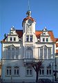
Renovated town hall in 2008


Economy and Infrastructure
traffic


Ostritz is located on the federal highway 99 between Görlitz and Zittau , which was built in 1825 instead of the old traffic connection that took a western route at the southern exit of the town, the Chaussee. There is also an important road connection in a north-westerly direction via Bernstadt ad Eigen to Löbau and the A4 towards Dresden .
The city is on the Neißetalbahn , which connects Zittau with Görlitz. Due to the demarcation of 1945 , the Ostritzer station east of the Neisse was now in Krzewina (Grunau) in the area under Polish administration. The bridge, which was blown up in 1945, was rebuilt, but only with half the width of the abutments. It was not until 1948 that the responsible offices in the former Soviet occupation zone in Germany and Poland agreed to facilitate through traffic. After that, travelers could only use the makeshift border bridge to and from the Krzewina Zgorzelecka train station . This was strictly monitored by the Polish military, so that deviating from the prescribed route or the platforms was impossible. Since 1990 the Neisse bridge has also served as an official border crossing for pedestrians and cyclists between Ostritz and Krzewina Zgorzelecka. When Poland joined the European Union in 2004, customs formalities were no longer necessary, while passport controls were carried out until Poland joined the Schengen Agreement in December 2007.
Ostritz has signed a letter of intent with its neighboring Polish city to replace the makeshift Neisse bridge on Bahnhofstrasse with a new one that uses at least the original width of the existing abutment. This means that cars could cross the Neisse again. It was also decided to rebuild the monastery bridge in the St. Marienthal district. Despite Poland's accession to Schengen and the elimination of formalities at government level, both projects have not yet been implemented due to a lack of financial resources.
Others
Ostritz is known as the energy- ecological model town of Ostritz- St. Marienthal , which is committed to the use of regenerative energy sources.
Ostritz also became known through the large concerts of right-wing radical bands that have been organized by neo-Nazis since 2018, as well as the opposing and multiple award-winning Ostritz peace festivals to celebrate and promote democracy and an open society.
Personalities
- Christian August Pfaltz (1629–1702), canon at St. Vitus Cathedral in Prague, important Catholic preacher and writer
- Mechthild von der Neisse (1647–1699), Cistercian nun in the St. Marienthal monastery, important mystic and herbalist
- Gottfried Tollmann (1680–1766), Protestant pastor and hymn poet
- Hermann Kurz (1723–1795), Abbot of Hohenfurth
- Karl Heinrich Seibt (1735–1806), educator and Catholic theologian
- Franz Gareis (1775–1803), painter
- Joseph Gareis (1778–1844), sculptor
- Johann Gottlieb Gareis (1781–1859) musician at the Nationaltheater Berlin, royal chamber musician
- Joseph Zacharias Müller (1782–1844), philologist
- Anton Johann Gareis (1793–1863), painter, lithographer and etcher.
- Henriette Sontag (1806–1854), opera singer
- Franz Bernhard Schiller (1815–1857), sculptor
- Edmund Kretschmer (1830–1908), composer
- Erna von Abendroth (1887–1959), nurse
- Julius Rolle (1889–1977), teacher and author ( Heimatbuch der Stadt Ostritz , self-published by the city of Ostritz, 1990)
- Josef Adolf König (1898–1973), politician (KPD / SED) and member of parliament
- Alfred Zerbel (1904–1987), officer in the Reichswehr, Wehrmacht and Bundeswehr, 1959–1964 inspector of the Bundeswehr Army
- Bruno Heinrich (1908–1992), Austrian Cistercian, 41st abbot of the Stams monastery
- Emil Pischel (1908–1989), painter
- Hans Pflugbeil (1909–1974), church musician and founder of the Greifswald Bach Week
- Alfred Krause (1915–1988), politician (CDU)
- Klaus Fröba (* 1934), writer
See also
literature
- Cornelius Gurlitt : Ostritz. In: Descriptive representation of the older architectural and art monuments of the Kingdom of Saxony. 29. Issue: Amtshauptmannschaft Zittau (Land) . CC Meinhold, Dresden 1906, p. 146.
Web links
- City website
- Ostritz in the Digital Historical Directory of Saxony
- Article about the energy-ecological model city Ostritz
Individual evidence
- ↑ Population of the Free State of Saxony by municipalities on December 31, 2019 ( help on this ).
- ↑ oberlausitzer-woerterbuch.de
- ↑ Ernst Eichler , Hans Walther (Ed.): Historisches Ortnamesbuch von Sachsen , Berlin 2001, ISBN 3-05-003728-8 , Volume II, page 144
- ^ Ostritz in the Digital Historical Directory of Saxony
- ↑ Area changes from January 1, 1994 to December 31, 1994. (PDF; 64 kB) State Statistical Office of the Free State of Saxony, accessed on October 1, 2012 .
- ↑ Results of the 2019 municipal council elections
- ↑ statistik.sachsen.de
- ↑ The history of the city of Ostritz. Retrieved June 28, 2013 .
- ↑ 3sat.de
- ↑ ostritzer-friedensfest.de
- ↑ deutscher-engagementpreis.de
- ↑ gegen-vergessen.de

Bad Muskau (Mužakow) | Beiersdorf | Bernstadt ad Eigen | Bertsdorf-Hörnitz | Boxberg / OL (Hamor) | Dürrhennersdorf | Ebersbach-Neugersdorf | Gablenz (Jabłońc) | Goerlitz | Groß Düben (Dźěwin) | Großschönau | Großschweidnitz | Chickens | Hainewalde | Herrnhut | Hohendubrau (Wysoka Dubrawa) | Horka | Jonsdorf | Kodersdorf | Königshain | Kottmar | Krauschwitz (Krušwica) | Kreba-Neudorf (Chrjebja-Nowa Wjes) | Lawalde | Leutersdorf | Löbau | Markersdorf | Mittelherwigsdorf | Mücka (Mikow) | Neißeaue | Neusalza-Spremberg | Niesky | Oderwitz | Olbersdorf | Oppach | Ostritz | Oybin | Quitzdorf am See | Reichenbach / OL | Rietschen (Rěčicy) | Rosenbach | Rothenburg / OL | Loop (slepo) | Schönau-Berzdorf ad Eigen | Schönbach | Schöpstal | Seifhennersdorf | Trebendorf (Trjebin) | Vierkirchen | Forest hooves | White chisel (Wuskidź) | White water (Běła Woda) | Zittau