
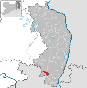
Leutersdorf (Upper Lusatia)
| coat of arms | Germany map | |
|---|---|---|

|
Coordinates: 50 ° 57 ' N , 14 ° 39' E |
|
| Basic data | ||
| State : | Saxony | |
| County : | Goerlitz | |
| Height : | 392 m above sea level NHN | |
| Area : | 17.08 km 2 | |
| Residents: | 3483 (Dec. 31, 2019) | |
| Population density : | 204 inhabitants per km 2 | |
| Postal code : | 02794 | |
| Primaries : | 03586, 035842 | |
| License plate : | GR, LÖB, NOL, NY, WSW, ZI | |
| Community key : | 14 6 26 280 | |
| Community structure: | 6 districts | |
| Address of the municipal administration: |
Hauptstrasse 9 02794 Leutersdorf |
|
| Website : | ||
| Mayor : | Bruno Scholze ( CDU ) | |
| Location of the municipality of Leutersdorf in the district of Görlitz | ||
  |
||

Leutersdorf ( Upper Lusatian : Leckerschdurf ) is a municipality in the Görlitz district of the Free State of Saxony with the capital of the same name.
geography

Leutersdorf is located on the Leutersdorfer Wasser in the south of Upper Lusatia , right on the Czech border. Neighboring communities are Seifhennersdorf , Großschönau and Varnsdorf in the south, Ebersbach-Neugersdorf in the northwest, Kottmar in the north and Oderwitz in the east.
There are several smaller mountains in the municipality:
- Oberoderwitzer Spitzberg (510 m)
- Spitzkunnersdorfer Spitzberg (471 m)
- Warnsdorfer Spitzberg (544 m)
- Wacheberg (452 m)
Local division
The municipality of Leutersdorf is divided into the following districts:
history
Leutersdorf was mentioned for the first time in 1347 under the name Lutgersdorf or Luitgersdorf. Spitzkunnersdorf was first mentioned in the same year as Kirchdorf Cunarsdorf and in 1384 as Connersdorf. The villages were divided several times between different noble local lords in the 15th and 16th centuries.
Mittel- and Oberleutersdorf as well as Cunnersdorf came under the rule of the Elector of Saxony in 1635 with Upper Lusatia. Large parts of today's municipality with Niederleutersdorf , which belonged to the Rumburg rule , remained part of the Kingdom of Bohemia . The Lords of Rumburg, members of the House of Liechtenstein since 1681, initially had the largest part of this area managed by a manorial farm. In the 18th century the villages of Josephsdorf , Neuwalde and Neuleutersdorf were established there . In 1784, a village judge was appointed in Niederleutersdorf , making the place an independent municipality. In terms of church, however, the Catholic residents belonged to Rumburg. The soap pond to the south broke in 1803 and was not dammed again. The main town of Leutersdorf was split into eight political communities around 1830, four of which were on Bohemian territory. After the establishment of the German Customs Union , the pascherei in Leutersdorf took on enormous proportions; almost all residents occasionally smuggled across the unmanageable border, and a large part of them ran the fancy dress business.


As a result of the main border and territorial recess between the Kingdom of Saxony and the Austrian Empire on March 5, 1848, the Bohemian enclave Niederleutersdorf came to Saxony on March 12, 1849. In 1870 Mittel- and Oberleutersdorf were united into one community and in 1907 Nieder-, Ober- and Mittelleutersdorf as well as Josephsdorf and Hetzwalde formed the community of Leutersdorf, to which the Catholic Neuleutersdorf joined in 1922. Since January 1, 1998, Spitzkunnersdorf has also been part of the Leutersdorf community. In 1956 the episode was changed from Seifhennersdorf to Leutersdorf. 1998 Spitzkunnersdorf was incorporated with Wiesenthal and Neuspitzkunnersdorf .
Leutersdorf was also made famous by the robber captain Johannes Karasek, who with his band of robbers at the end of the 18th century drove mischief in the vicinity and had his hiding place in the enclave .

Church building
- Due to the special history of the village, there are two larger churches in the Leutersdorf district:
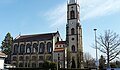
- The Catholic parish church of the Assumption was built in 1862 according to plans by the Zittau master builder Carl August Schramm , a student of Karl Friedrich Schinkel . A special feature of the neo-Gothic building is the nationwide unique roof covering with colored beaver tails .
- The Evangelical Lutheran Christ Church is a sister church of the Kreuzkirche Seifhennersdorf. The neo-Gothic building from 1865 is easy to see that it was also designed by Carl August Schramm. It replaced a nearby church from 1690. After extensive renovation, the church, which had been closed since 2004 because of dilapidation, was reopened to the public in 2006.
- In the district of Spitzkunnersdorf there is an Evangelical Lutheran church.

Catholic Parish Church of the Assumption

Portal parish church of the Assumption
Evangelical Lutheran Christ Church

Christ Church portal


politics
(+ 28.5 % p )
(-28.5 % p )
Since the municipal council election on May 26, 2019 , the 14 seats of the municipal council have been distributed among the individual groups as follows:
- Free voters Leutersdorf (FWL): 8 seats
- Christian Democratic Union of Germany (CDU): 6 seats
Regular events
- Whitsun singing in the Spitzkunnersdorf district; Whit Monday at Hofeberg
- Big soap box race in the district of Spitzkunnersdorf; annually on the last Saturday in June
- Summer festival of the clubs in the district of Spitzkunnersdorf; annually on the first weekend in August on the sports field
- UNICEF party at the Forstenschanze in the Spitzkunnersdorf district; annually in September
- Euroregional chess week (includes a total of 3 tournaments for different target groups)
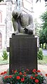
Monuments
There are three monuments in front of the Evangelical Lutheran Christ Church:
- Memorial to the fallen warriors of the German Wars of Unification (1866, 1870 and 1871)
- Memorial to the fallen of the First World War (1914–1918)
- Memorial to the victims of German fascism and militarism

Memorial to those who fell in the German Wars of Unification
Memorial to the First World War

Memorial to the victims of German fascism and militarism
.jpg)


Personalities
- Anton Dreyssig (1774–1815), organist and choir director in Dresden
- Jonathan Christoph Berthold (1787–1864), doctor, first homeopath in Upper Lusatia
- Johannes Herz (1877–1960), Lutheran theologian and pastor
- Aloys Scholze (1893–1942), Catholic pastor in Leutersdorf; Died in Dachau concentration camp
- Walter Brödel (1911–1997), mathematician
- Siegfried Pilz (1925–2011), artistic cyclist
- Hans Schiller (1928-2000), dialect poet
- Joachim Gocht (1935–2008), jazz and entertainment musician
- Günter Gocht (* 1938), jazz and entertainment musician
- Winfried Pilz (1940–2019), Catholic priest, songwriter
- Konrad Beyreuther (* 1941), professor of molecular biology at the Ruprecht-Karls-Universität Heidelberg and honorary state councilor for life and health protection in the state government of Baden-Württemberg
Honorary citizen
- 2011 Erika Rother
traffic
The Leutersdorf stop was on the Mittelherwigsdorf – Varnsdorf – Eibau railway line ; However, no passenger trains stop here. The KVG Dreiländereck provides bus connections to Eibau, Neugersdorf, Zittau and Olbersdorf.
literature
- Hermann Alexander Gühler: History of the church in Oberleutersdorf and plan of its new building as a memorandum of the establishment of a church building capital in the parish of Leutersdorf . Leutersdorf / Neusalza 1852 ( digitized version )
- Cornelius Gurlitt : Leutersdorf. In: Descriptive representation of the older architectural and art monuments of the Kingdom of Saxony. 29. Issue: Amtshauptmannschaft Zittau (Land) . CC Meinhold, Dresden 1906, p. 105.
Web links
- List of cultural monuments in Leutersdorf (Oberlausitz)
- Internet presence of the community of Leutersdorf
- Leutersdorf (Oberlausitz) in the digital historical directory of Saxony
- Catholic parish Leutersdorf
- Evangelical Lutheran Parish Leutersdorf
Individual evidence
- ↑ Population of the Free State of Saxony by municipalities on December 31, 2019 ( help on this ).
- ↑ Upper Lusatian Dictionary: Letter L. Accessed on March 22, 2013 .
- ^ StBA: Changes in the municipalities, see 1998
- ↑ Results of the 2019 municipal council elections
- ^ Website of the organizing SC 1994 Oberland eV

Bad Muskau (Mužakow) | Beiersdorf | Bernstadt ad Eigen | Bertsdorf-Hörnitz | Boxberg / OL (Hamor) | Dürrhennersdorf | Ebersbach-Neugersdorf | Gablenz (Jabłońc) | Goerlitz | Groß Düben (Dźěwin) | Großschönau | Großschweidnitz | Chickens | Hainewalde | Herrnhut | Hohendubrau (Wysoka Dubrawa) | Horka | Jonsdorf | Kodersdorf | Königshain | Kottmar | Krauschwitz (Krušwica) | Kreba-Neudorf (Chrjebja-Nowa Wjes) | Lawalde | Leutersdorf | Löbau | Markersdorf | Mittelherwigsdorf | Mücka (Mikow) | Neißeaue | Neusalza-Spremberg | Niesky | Oderwitz | Olbersdorf | Oppach | Ostritz | Oybin | Quitzdorf am See | Reichenbach / OL | Rietschen (Rěčicy) | Rosenbach | Rothenburg / OL | Loop (slepo) | Schönau-Berzdorf ad Eigen | Schönbach | Schöpstal | Seifhennersdorf | Trebendorf (Trjebin) | Vierkirchen | Forest hooves | White chisel (Wuskidź) | White water (Běła Woda) | Zittau