Grand Dubrau
| coat of arms | Germany map | |
|---|---|---|

|
Coordinates: 51 ° 15 ' N , 14 ° 28' E |
|
| Basic data | ||
| State : | Saxony | |
| County : | Bautzen | |
| Height : | 195 m above sea level NHN | |
| Area : | 54.22 km 2 | |
| Residents: | 4249 (Dec. 31, 2019) | |
| Population density : | 78 inhabitants per km 2 | |
| Postal code : | 02694 | |
| Primaries : | 035932 (Commerau, Großdubrau, Klix) , 035934 (Quatitz, Sdier) | |
| License plate : | BZ, BIW, HY, KM | |
| Community key : | 14 6 25 160 | |
| Community structure: | 20 districts | |
| Address of the municipal administration: |
Ernst-Thälmann-Strasse 9 02694 Großdubrau |
|
| Website : | ||
| Mayor : | Lutz Mörbe (independent) | |
| Location of the community Großdubrau in the district of Bautzen | ||
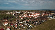
Großdubrau , Upper Sorbian , is a place and the associated municipality north of Bautzen in Eastern Saxony . It belongs to the Upper Lusatia and belongs to the official settlement area of the Sorbs .
The place name is derived from the Sorbian word dub for "oak". Dubrawa can be translated as "oak forest".
geography
The place Großdubrau is located about twelve kilometers north of the large district town of Bautzen on an elevation west of the Spreeniederung at about 200 meters above sea level. NN. It is a gravel terrace as a remnant of the Pleistocene river course of the Elbe . All neighboring places are between 20 and 40 meters lower. The immediate area is wavy and predominantly wooded. Forests make up almost a third of the municipality's area. The numerous ponds and lakes account for another 7%. Large parts of the community are part of the Upper Lusatian Heath and Pond Landscape Biosphere Reserve .
Großdubrau itself is a street green village with extensions mainly to the north.
history
The settlement was first mentioned in 1343 as Dubra . Until 1628 the manorial rule lay with the Bautzen cathedral monastery ; Around 1630, a grand brewery manor is mentioned for the first time.
Already at the beginning of the 19th century coal, clay and kaolin were extracted in pits around the place. From around 1890, Großdubrau experienced a rapid economic upswing and a rapid increase in population due to the expansion of the mining sites in the immediate vicinity ( Margarethenhütte , Adolfshütte ) and the connection to the Löbau – Radibor railway line in 1906 . Within twenty years the population quadrupled from 248 in 1890 to 978 in 1910. The small, predominantly Sorbian village of Angerdorf became an industrial settlement dominated by Germans. In 1925 the place with 1200 inhabitants - the majority of Protestant denominations - was one of the largest villages in Upper Lusatia. At that time, Margarethenhütte was one of the world's leading companies in the electro-ceramic sector.
In 1936 the neighboring towns of Brehmen and Kleindubrau were incorporated.
In 1972, passenger traffic at Großdubrau station was discontinued. In 1998 the railway line and the Großdubrauer Bahnhof were finally shut down.
In 1991, one year after reunification , production in the Margarethenhütte and with it the history of Großdubrau as an industrial location ended. The workers were laid off.
In the community reforms of the 1990s, the communities Commerau , Klix , Quatitz and Sdier and the neighboring town of Crosta came to Großdubrau.
population
For his statistics on the Sorbian population in Upper Lusatia, Arnošt Muka determined a population of 227 inhabitants in the 1880s; 185 of them were Sorbs (81%) and 42 Germans. As everywhere in the Protestant part of the Sorbian settlement area, the proportion of Sorbian speakers has fallen sharply since then; in Großdubrau particularly favored by the industrial development and the accompanying influx of workers.
Community structure
20 districts with the formerly independent municipalities (Sorbian names in brackets):
|
|
politics
The elections of previous years resulted in the following allocation of seats:
| Parties and constituencies | 2019 | 2014 | 2009 | 2004 | ||||
|---|---|---|---|---|---|---|---|---|
| % | Seats | % | Seats | % | Seats | % | Seats | |
| Independent voters' association (UWV) | 78.9 | 13 | 72.8 | 12 | 68.3 | 11 | 45.3 | 7th |
| Christian Democratic Union of Germany (CDU) | 21.1 | 3 | 27.2 | 4th | 31.7 | 5 | 54.7 | 9 |
| total | 100.0 | 16 | 100.0 | 16 | 100.0 | 16 | 100.0 | 16 |
| voter turnout | 68.1% | 58.8% | 54.8% | 53.1% | ||||
The municipal administration aimed for a merger with the neighboring municipality of Radibor in 2008 . For this reason, on March 2, 2008, a citizens' initiative aimed at bringing about a community merger was carried out. A clear majority of the large Dubai voters decided against the merger, while in Radibor a narrow majority voted for the move.
Infrastructure
The federal road 156 ( Weißwasser -Bautzen) crosses Sdier and Commerau, while the state road 107 ( Niedergurig - Radibor ) leads past the Bautzen dam through Jeschütz and Quatitz. The remaining districts are connected by local roads. The Bautzen-Ost junction of federal motorway 4 ( Dresden - Wrocław ) is eight kilometers south of Großdubrau.
The Klix airfield is located east of Großdubrau near the district of the same name and is mainly used for gliding and powered flights with small machines.
The bus line 104 ( Regiobus ) connects Großdubrau with Bautzen.
Education and sport
The community Großdubrau has a primary school , and the free secondary school "Johann Heinrich Pestalozzi" is located in the village. The state middle school was closed in 2006.
The sports club "SV 1896 Großdubrau" is based in the village. The women's team reached the first round of the DFB Cup in the 2005/2006 season.
Town twinning
Culture and sights
- Technical Museum Margarethenhütte , Großdubrau
- Blue Adriatic Recreation Area in Crosta
- Klix village church with epitaph for Franz von Nostitz († 1576) showing a crucifixion scene from the Cranach school
- “Klix glider airfield” in Särchen
- Castle in Spreewiese
- former manor in Kauppa
- Water tower with a granite base
- Two- axis hand pressure sprayer of the Quatitz volunteer fire brigade
- Monument to Andreas Gärtner and Otto Lehmann in Quatitz
- Stone crosses in the district of Dahlowitz and Göbeln
Personalities
- Andreas Gärtner ( Handrij Zahrodnik ; 1654–1727), mechanic, model maker; born in Quatitz
- Ota Wićaz / Otto Lehmann (1874–1952), scientist; born in Quatitz
- Johann Cilenšek (1913–1998), composer; born in Großdubrau
- Jürgen Lehmann (* 1934), writer; born in Großdubrau
- Steffi Walter (1962–2017), luge rider; lived in Großdubrau
literature
- Großdubrau am Heiderand. (= The beautiful Bautzener Land , booklet 6.) Council of the Bautzen district, 1957.
- Quatitzer Hefte , on the early history up to the first mention in Anno 1327, authors' association, 1995 (soil finds in Quatitz, Dahlowitz, Kronförstchen and Jeschütz)
Web links
- Großdubrau in the Digital Historical Directory of Saxony
- Margarethenhütte Museum
- Spreewiese district
Individual evidence
- ↑ Population of the Free State of Saxony by municipalities on December 31, 2019 ( help on this ).
- ↑ Saxon Sorbs Act , Annex to Section 3 (2)
- ↑ Stefan Locke: From the end of speechlessness. Ever since Saxony's Minister of Integration, Petra Köpping, started talking about the tough period after the reunification, shattering stories have come to light. In: Frankfurter Allgemeine Zeitung of August 3, 2017, p. 3.
- ↑ Ernst Tschernik: The development of the Sorbian population . Akademie-Verlag, Berlin 1954, p. 53 .
- ↑ information from the municipal administration; As of December 31, 2016
- ↑ Results of the 2019 municipal council elections


