Nowogrodziec
| Nowogrodziec | ||
|---|---|---|

|
|
|
| Basic data | ||
| State : | Poland | |
| Voivodeship : | Lower Silesia | |
| Powiat : | Bolesławiec | |
| Area : | 16.17 km² | |
| Geographic location : | 51 ° 12 ′ N , 15 ° 24 ′ E | |
| Height : | 180 m npm | |
| Residents : | 4243 (Jun. 30, 2019) |
|
| Postal code : | 59-730 | |
| Telephone code : | (+48) 75 | |
| License plate : | DBL | |
| Economy and Transport | ||
| Street : | Lubań - Bolesławiec | |
| Next international airport : | Wroclaw | |
| Gmina | ||
| Gminatype: | Urban and rural municipality | |
| Gmina structure: | 14 villages | |
| Surface: | 176.26 km² | |
| Residents: | 15,214 (June 30, 2019) |
|
| Population density : | 86 inhabitants / km² | |
| Community number ( GUS ): | 0201043 | |
| Administration (as of 2007) | ||
| Mayor : | Robert Relich | |
| Address: | Rynek 1 59-730 Nowogrodziec |
|
| Website : | www.nowogrodziec.pl | |
Nowogrodziec [ nɔvɔˈgrɔʥɛʦ ] (German Naumburg am Queis ) is a small town in the powiat Bolesławiecki (Bunzlau district) in the Polish Voivodeship of Lower Silesia . The town and country municipality of the same name has around 15,000 inhabitants (4,000 of them in the city on 16.17 km²) and is a member of the Neisse Euroregion .
Geographical location
Nowogrodziec is located in the historical region of Lower Silesia on the right, eastern bank of the Queis . The old town center is located on a small hill at the mouth of the Ivenitz (Polish Iwnica ) in the Queis. The historic Hohe Strasse ran through the town . Wroclaw , the capital of Lower Silesia, is about 130 kilometers to the east .
history

The area around Naumburg was settled in the border forests with German farming villages after 1220 . "Nuenburg" was laid out in 1233 by order of Duke Heinrich I of Silesia at the ford through the Queis as a city by Vogt Themo. As a market and court location for eleven villages under German law, it received Löwenberg town charter and as a border town to the Queiskreis a customs office. The main street, which was bordered by the Niedertor to the west and the Obertor to the east, was designed in an oval shape. A rectangular marketplace was created in the center. The until then ducal patronage of the parish church of St. Peter and Paul was transferred in 1247 to the monastery of the Magdalene nuns founded that year . Economically disadvantageous was that the softening of Bunzlau extended to the city limits of Naumburg. The development was also inhibited by the changing noble and spiritual landlords. Presumably from 1233 to 1408 it was the von Landskron, then the Rechenberg auf Klitschdorf until 1491 , the von Warnsdorf auf Gießmannsdorf from 1491 to 1495 and then the Magdalenerinnenkloster until the secularization in 1810.
In addition to the cloth making, mainly ceramics were produced in Naumburg . The first pottery in Naumburg was established in 1547. This branch of industry developed over the course of the following centuries to become the most important in the city. Until the end of the 19th century, Naumburg was the largest and most important pottery town in Silesia. In 1882 pottery in Naumburg experienced a high point with a total of 25 potteries in the city. The town was the Silesian pottery town and in the importance and size of the guild was far ahead of Bunzlau, which is better known for its pottery .
After numerous city fires in the 17th and 18th centuries, the city's most important buildings were rebuilt. The Catholic parish church was built in the baroque style between 1789 and 1793. At the same time, Naumburg had around 1150 inhabitants. Until 1815 Naumburg was a border town to Upper Lusatia .
Around 1900 Naumburg had a new Protestant church and two Catholic churches. In 1904 Naumburg was connected to the Prussian rail network.
In July 1936 the Confession Synod of the Confessing Church of the Church Province of Silesia met in Naumburg (so-called Naumburg Synod ).
After the end of the Second World War , Naumburg was placed under Polish administration by the Soviet occupying forces in the summer of 1945 . The Poles used the place name Nowogrodziec for the city . Insofar as the German residents had not fled, they were subsequently expelled by the local Polish administrative authorities .
From 1975 to 1998 the place belonged to the Jelenia Góra Voivodeship .
Demographics
| year | Residents | Remarks |
|---|---|---|
| 1787 | 1,148 | |
| 1816 | 1,153 | |
| 1825 | 1,424 | |
| 1840 | 1,752 | including 352 Protestants and 1,400 Catholics |
| 1843 | 1,701 | At the end of the year |
| 1871 | 2.006 | including 450 Evangelicals |
| 1890 | 2.165 | 728 Protestants, 1,433 Catholics and four Jews |
| 1905 | 1,954 | including 759 Evangelicals |
| 1933 | 1.996 | |
| 1939 | 2,239 |
| year | Residents | Remarks |
|---|---|---|
| 1961 | 2,106 | |
| 1970 | 2,339 |
Attractions
- The Catholic parish church of St. Peter and Paul was first mentioned in 1247. After numerous city fires, it was rebuilt in the baroque style between 1789 and 1793. The tower dome was built between 1879 and 1880.
- Ruins of the Magdalen monastery, which burned out in 1945
- Baroque town hall from 1795, rebuilt in 1880
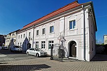
- Historic town houses on the Ring
- Remains of the medieval city fortifications
- St. Nicholas Church in the district of Ołdrzychów (Ullersdorf am Queis) incorporated in 1938
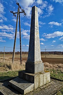
- Ebendorf Kursächsische post mile column with the number 112 (counting from Leipzig ) in the course of the Via Regia , not far from the old border to Upper Lusatia , in the form of a full mile column from 1725, which was restored on the occasion of Poland 's accession to the EU in 2004.
Rural municipality of Nowogrodziec
In addition to the city center, Nowogrodziec also includes a rural municipality with the following districts:
- Czerna (Tschirne , 1937–1945 Tonhain)
- Gierałtów (Gersdorf a. Queis)
- Godzieszów (Günthersdorf)
- Gościszów (Gießmannsdorf)
- Kierżno (Herrmannsdorf)
- Milików (Herzogswaldau)
- Nowa Wieś (Neundorf)
- Ołdrzychów (Ullersdorf a. Queis)
- Parzyce (Paritz)
- Wykroty (Waldau / Upper Lusatia)
- Zabłocie (Thiergarten)
- Zagajnik (Haidewaldau / Upper Lusatia)
- Zebrzydowa (Siegersdorf)
Parish partnership
- Großdubrau (Upper Lusatia)
Personalities
- Joseph Schnabel (1767–1831), church musician, cathedral music director, university music director in Wroclaw
- Hugo Emil Schober (1820–1882), German agricultural scientist
- Gustav Dickhuth (1825–1893), second mayor and honorary citizen of Breslau
- Otto Rust (1871–1945), archpriest
- Gertrud Bäumer (1873–1954), German women's rights activist and politician, lived from 1933 to 1944/45 in the rural community of Gießmannsdorf (now Gościszów)
- Hans Kampffmeyer (1876–1932), representative of the garden city movement, founder of the garden city Karlsruhe
- Bruno Fehlisch (1889 – after 1952), German politician (SPD) and member of the state parliament in Prussia
- Oskar von Boenigk (1893–1946), fighter pilot in World War I, holder of the order Pour le Mérite and major general in World War II
- Rudolf Rückert (* 1929), German politician (CDU) and Lord Mayor of Salzgitter
- Hans Skirecki (1935–2016), German writer and translator
literature
- Johann Georg Knie : Alphabetical-statistical-topographical overview of the villages, spots, towns and other places of the royal family. Prussia. Province of Silesia, including the Margraviate of Upper Lusatia, which now belongs entirely to the province, and the County of Glatz; together with the attached evidence of the division of the country into the various branches of civil administration . Breslau 1830, pp. 975-976.
- Franz Micke: Documented history of the city and the former monastery Naumburg am Queis . Bunzlau 1844.
See also
List of places owned by the Magdalen convent Naumburg am Queis
Web links
Individual evidence
- ↑ a b population. Size and Structure by Territorial Division. As of June 30, 2019. Główny Urząd Statystyczny (GUS) (PDF files; 0.99 MiB), accessed December 24, 2019 .
- ↑ a b c d e f g h Hugo Weczerka (Hrsg.): Handbook of historical sites . Volume Silesia (= Kröner's pocket edition . Volume 316). Kröner, Stuttgart 1977, ISBN 3-520-31601-3 , p. 331.
- ↑ a b Meyer's Large Conversation Lexicon . 6th edition, Volume 14, Leipzig / Vienna 1908, pp. 467–468.
- ^ Leopold Krug , AA Mützell: New topographical-statistical-geographical dictionary of the Prussian state . Elaborated and edited by Alexander August Mützell. Volume 3: Kr-O. Halle 1822, p. 253, item 233.
- ^ Johann Georg Knie : Alphabetical-statistical-topographical overview of the villages, spots, cities and other places of the royal family. Prussia. Province of Silesia, along with the appended division of the country into the districts of the three royal governments, the principalities and districts contained therein, with details of the area, the central elevation above the sea, the inhabitants, buildings, the cattle herd, etc. 2nd edition, Breslau 1845, P. 879.
- ^ W. Dieterici (Ed.): The statistical tables of the Prussian state after the official recording of the year 1843 . Nicolai, Berlin 1845, p. 215.
- ^ Gustav Neumann : The German Empire in geographical, statistical and topographical relation . Volume 2, GFO Müller, Berlin 1874, p. 221.
- ^ A b c Michael Rademacher: German administrative history from the unification of the empire in 1871 to the reunification in 1990. bunzlau.html # ew39bnznaumburg. (Online material for the dissertation, Osnabrück 2006).


