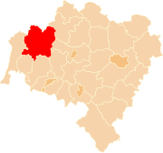
Powiat Bolesławiecki
| Powiat Bolesławiecki | |
|---|---|

|

|
| Basic data | |
| State : | Poland |
| Voivodeship : | Lower Silesia |
| County town : | Bolesławiec |
| Area : | 1,303.26 km 2 |
| Residents : | 90,108 (June 30, 2019) |
| Population density : | 69 inhabitants / km 2 |
| Degree of urbanization : | 51.12% |
| Telephone code : | (+48) 75 |
| License plate : |
DBL
|
| Circle structure | |
| Municipalities : | 1 |
| Urban and rural communities : | 1 |
| Rural communities : | 4th |
| Starostei (as of 2018) | |
| Starost : | Tomasz Gabrysiak |
| Address: | pl. Marsz. Józefa Piłsudskiego 2 59-700 Bolesławiec |
| Website : | powiatboleslawiecki.pl |
The powiat Bolesławiecki is a powiat ( district ) around the city of Bolesławiec (Bunzlau) in the Polish Voivodeship of Lower Silesia . The district has an area of 1303.26 km², with around 90,000 inhabitants.
He belongs to the Euroregion Neisse .
cities and communes
The powiat comprises six municipalities ( gmina ), of which one urban municipality, one urban and rural municipality, whose main town of the same name has municipal rights, and four rural municipalities.
- Population as of December 31, 2009
Borough
- Bolesławiec (Bolesławiec) - 40.021
Urban and rural municipality
- Nowogrodziec (Naumburg am Queis) - 14,912
Rural communities
- Gmina Bolesławiec - 13,140
- Gromadka (Gremsdorf) - 5,443
- Osiecznica (Wehrau) - 7,394
- Warta Bolesławiecka (Old Warthau) - 8,141
Circle of partners

Unveiling of the memorial for Paul Sauer (2014)
On 16 February 2001 a delegation from was on a visit Bolesławiec in Siegburg the partnership agreement between the Rhein-Sieg-Kreis officially signed and the District Bolesławiec (Powiat Bolesławiec).
See also
Web links
Commons : Powiat Bolesławiecki - collection of images, videos and audio files
Individual evidence
- ↑ population. Size and Structure by Territorial Division. As of June 30, 2019. Główny Urząd Statystyczny (GUS) (PDF files; 0.99 MiB), accessed December 24, 2019 .
- ↑ Główny Urząd Statystyczny, "LUDNOŚĆ - STAN I STRUKTURA W PRZEKROJU TERYTORIALNYM", as of December 31, 2009 ( memento of June 23, 2010 on WebCite )

