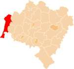
Powiat Zgorzelecki
| Powiat Zgorzelecki | |
|---|---|

|

|
| Basic data | |
| State : | Poland |
| Voivodeship : | Lower Silesia |
| County town : | Zgorzelec |
| Area : | 838.11 km 2 |
| Residents : | 89,612 (June 30, 2019) |
| Population density : | 107 inhabitants / km 2 |
| Degree of urbanization : | 69.27% |
| License plate : |
DZG
|
| Circle structure | |
| Municipalities : | 2 |
| Urban and rural communities : | 3 |
| Rural communities : | 2 |
| Starostei (Stand:) | |
| Starost : | Andrzej Tyc |
| Address: | ul.Bohaterów II Armii WP 8 59-900 Zgorzelec |
| Website : | www.powiat.zgorzelec.pl |
The powiat Zgorzelecki is a powiat ( district ) in the vicinity of the Polish city of Zgorzelec in the Lower Silesian Voivodeship . It covers a territory of 838 km², on which about 91,000 people live (as of 2016). The powiat belongs to the Euroregion Neisse .
The powiat was founded on January 1st, 1999. Its district area is not identical to the present-day Polish part of the former Silesian district of Görlitz ; It also contains parts of the former Zittau administration .
Communities
The powiat Zgorzelecki consists of seven communities ;
including two municipalities;
three urban-and-rural parishes ;
and two rural parishes
- Sulików ( Schönberg / Upper Lusatia )
- Zgorzelec (municipality) ( Görlitz -Land)
Web links
Commons : Powiat Zgorzelecki - collection of images, videos and audio files
Footnotes
- ↑ population. Size and Structure by Territorial Division. As of June 30, 2019. Główny Urząd Statystyczny (GUS) (PDF files; 0.99 MiB), accessed December 24, 2019 .
