Ołdrzychów
| Ołdrzychów | ||
|---|---|---|
 Help on coat of arms |
|
|
| Basic data | ||
| State : | Poland | |
| Voivodeship : | Lower Silesia | |
| Powiat : | Bolesławiec | |
| Geographic location : | 51 ° 12 ' N , 15 ° 23' E | |
| Residents : | ||
| Postal code : | 59-730 | |
| Telephone code : | (+48) 75 | |
| License plate : | DBL | |
| Economy and Transport | ||
| Next international airport : | Wroclaw | |
| administration | ||
| Website : | www.nowogrodziec.pl | |
Ołdrzychów (German Ullersdorf a. Queis ) is a district of the urban and rural community Nowogrodziec ( Naumburg a. Queis ) in the powiat Bolesławiecki in the Lower Silesian Voivodeship in Poland .
geography
Ołdrzychów is located 1.7 kilometers northwest of Nowogrodziec on the left bank of the Queis . Until 1816 it belonged to Upper Lusatia , after which it was incorporated into the Prussian province of Silesia .
history
Archaeological finds show that the area was settled in the Younger Stone Age, the Bronze Age and the Iron Age.
Around 1230, a Slavic patch was implemented under German law , which was first mentioned in 1305 as "Ulrichsdorf". The St. Nicholas Church, which was incorporated into the Meißnischen deanery Lauban , is occupied for the year 1310 with a "Conradus plebanus in Ulrici villa". In 1410 Ullersdorf belonged to Heinze von Seibersdorf, who sold it to the Magdalen convent in Naumburg am Queis that year . It remained in his possession until the secularization in 1810.
After the Congress of Vienna in 1815 Ullersdorf, which until then to fell precincts belonged Lauban together with the Ostoberlausitz of Prussia , from which it to the province of Silesia was connected. In 1816 it was incorporated into the newly established Bunzlau district. The district of Ullersdorf a. Queis consisted of the rural communities Paritz and Ullersdorf a. Queis.
From the middle of the 19th century, the rich clay deposits , which are attributed to the Löwenberg - Bunzlauer Kreidemulde , were of economic importance . A clay mine for china clay was built in 1858, followed by a coal mine in 1862 and the J Hersel chamotte and pottery factory in 1864/1865, which employed around 200 workers around 1880. The founder Josef Hersel (1831–1904) is buried in the churchyard and comes from a large Ullersdorf farming family. Hersel's grandfather Johann Anton Valentin Hersel (1765–1824) comes from Katholisch Hennersdorf . Around 1900 there were eight brown potteries in Ullersdorf. In 1904 Ullersdorf received a rail connection on the Hirschberg - Sagan line . In 1939 there were 970 inhabitants.
As a result of the Second World War, Ullersdorf and most of Silesia fell to Poland in 1945 and was renamed "Ołdrzychów". The German population was largely expelled unless they had already fled . Some of the newly settled residents were displaced from eastern Poland . 1959 Ołdrzychów was incorporated into Nowogrodziec. 1975-1998 Ołdrzychów belonged to the Jelenia Góra Voivodeship . In 1996 the rail link was closed.
Attractions
- The St. Nicholas Church was first mentioned in 1310.
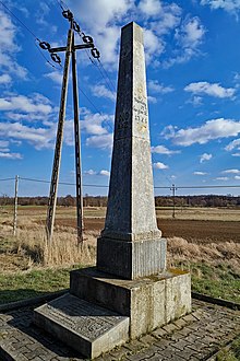
- The last Saxon postal mileage pillar with the number 112 (counting from Leipzig ) in the course of the Via Regia , is not far from the old border of Upper Lusatia and Silesia ( Queis bridge), in the form of a full mile pillar from 1725, which on the occasion of the EU accession of Poland was restored in 2004.
See also
List of places owned by the Magdalen convent Naumburg am Queis
literature
- Hugo Weczerka (Hrsg.): Handbook of the historical places . Volume: Silesia (= Kröner's pocket edition . Volume 316). Kröner, Stuttgart 1977, ISBN 3-520-31601-3 , p. 550.


