
Bautzen dam
| Bautzen reservoir Budyska rěčna zawěra |
|||||||
|---|---|---|---|---|---|---|---|
 |
|||||||
|
|||||||
|
|||||||
| Coordinates | 51 ° 13 '12 " N , 14 ° 27' 44" E | ||||||
| Data on the structure | |||||||
| Construction time: | 1968-1975 | ||||||
| Height above valley floor: | 16.50 m | ||||||
| Height above foundation level : | 19.40 m | ||||||
| Height of the structure crown: | 171.70 m | ||||||
| Building volume: | 950,000 m³ | ||||||
| Crown length: | 1652 and 426 m | ||||||
| Crown width: | 5.3 and 5.0 m | ||||||
| Slope slope on the air side : | 1: 1: 2 | ||||||
| Slope slope on the water side : | 1: 1: 2 | ||||||
| Data on the reservoir | |||||||
| Altitude (at congestion destination ) | 169.20 m | ||||||
| Water surface | 578 ha | ||||||
| Storage space | 44.6 million m³ | ||||||
| Total storage space : | 48.6 million m³ | ||||||
| Catchment area | 310 km² | ||||||
| Design flood : | 194 m³ / s | ||||||
 |
|||||||

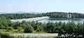
The Bautzen dam , in Upper Sorbian Budyska rěčna zawěra , is located north of Bautzen in Upper Lusatia in Saxony and is fed by the Spree . The dam is used for the supply of industrial water , for raising the low water level, for flood protection , but above all for the constant supply of water to the Boxberg power plant via the Spree and also for fishing and recreational activities. It is located on the territory of the Burk district of Bautz .
construction
The barrier structure consists of two earth embankments with a bituminous outer skin seal. The dam was built from 1968 to 1975 and commissioned in 1977. Both dams were repaired from 1999 to 2002. The Bautzen dam has an overflow system, through which a maximum of 225 m³ per second can flow off during high water. The facility has been used three times so far, namely during the floods in 1981, August 2010 and June 2013.
The villages of Malsitz and Nimschütz used to be at the site of the dam . The residents were relocated. During the repair work, the remains of the villages on the bottom of the empty dam were accessible.
The dam has an Oehna pre- dam and a Neumalsitz pre-basin, whose dams are also 102 and 210.2 m long dams. Swimming, sailing and other recreational sports in and around the lake are possible. In summer, however, the dam is often infested with blue-green algae , so the beaches often have to be closed. Hiking around the lake is also possible. In summer 2005 the dam was officially recommended as a bathing water due to the good water quality.
The only island in the reservoir is the so-called "bird island" near the former location of Malsitz. Here was an old quarry. Entry is prohibited for nature conservation reasons.

Reservoir of the Bautzen dam, aerial photo (2017)
View from the vantage point, on the left the smaller Trasse III dam

The old course of the Spree in the drained dam
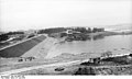
The test jam started two weeks before the planned date at the newly constructed industrial water dam in Bautzen. (June 27, 1974)

Built by VEB Spezialbaukombinat Wasserbau


See also
Web links
Individual evidence
- ↑ Christoph Scharf: Why did the dam overflow? in: Sächsische Zeitung of August 11, 2010