
Bas-Intyamon
| Bas-Intyamon | |
|---|---|
 |
|
| State : |
|
| Canton : |
|
| District : | Gruyère |
| BFS no. : | 2162 |
| Postal code : | 1665 Estavannens 1666 Villars-sous-Mont 1667 Enney |
| Coordinates : | 572 779 / 157 265 |
| Height : | 720 m above sea level M. |
| Height range : | 670–2252 m above sea level M. |
| Area : | 33.34 km² |
| Residents: | 1454 (December 31, 2018) |
| Population density : | 44 inhabitants per km² |
| Website: | www.bas-intyamon.ch |
 Landscape in Bas-Intyamon |
|
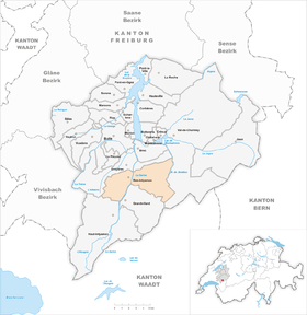
| Location of the municipality | |
  |
|
Bas-Intyamon is a municipality in the Gruyère district of the canton of Friborg in Switzerland . The municipality was created on January 1, 2004 through the merger of the previously independent municipalities Enney , Estavannens and Villars-sous-Mont . The local government is located in Enney.
geography
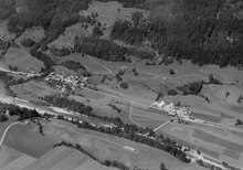
Bas-Intyamon is located about 6 km south-southeast of the district capital Bulle (as the crow flies). The municipality is located in the Haute-Gruyère, in the Intyamon valley of the Saane (French: Sarine), in the Friborg Alps east of the Moléson .
The area of the 33.3 km² municipality covers a section of Haute-Gruyère in the Freiburg Alps. The central part of the area is formed by the Saane valley, which extends in a south-north direction, with a flat valley floor that is up to 1.5 km wide. The streams Ruisseau des Praz , Ruisseau d'Afflon and Ruisseau du Bry flow into the Saane from the west, dividing the left slope of the valley into various foothills of the Moléson massif, including La Vudalla ( 1670 m above sea level ) and Vanil Blanc ( 1573 m above sea level ). In the west, the area extends into the valley of the Albeuve , which rises on the northern slope of the Moléson.
To the east of the Saane, the municipality extends over the adjacent mountain range with Dent du Chamois ( 1830 m above sea level ), Dent du Bourgo ( 1909 m above sea level ) and Les Merlas ( 1908 m above sea level ) into the Motélon valley . The Ruisseau de Motélon , a southern side stream of the Jaunbach , forms the eastern border. In this valley are the remote Alps Varvalanne and Porcheresse . Above Porcheresse, the Dent de Folliéran at 2340 m above sea level is on the limestone summit . M. reached the highest point of Bas-Intyamon. The northern border towards the Bulle basin runs through a narrow section of the Saan valley and over the Dent du Chamois rock ridge to the east. In 1997, 3% of the municipal area was accounted for by settlements, 39% for forests and woodlands, 48% for agriculture and a little more than 10% was unproductive land.
Bas-Intyamon consists of the villages Enney ( 720 m above sea level ), Villars-sous-Mont ( 758 m above sea level ) and Estavannens , which is made up of Estavannens-Dessous ( 770 m above sea level ) and Estavannens- Dessus ( 798 m above sea level ). The hamlets of La Chenau ( 807 m above sea level ) on the Ruisseau du Bry in the hollow west of Enney and Afflon ( 740 m above sea level ) on the alluvial cone of the Ruisseau d'Afflon on the western edge of the Saan valley and numerous individual farms also belong and alpine huts to the community. Neighboring communities to Bas-Intyamon are Gruyère , Val-de-Charmey , Grandvillard and Haut-Intyamon .
population
With 1,454 inhabitants (as of December 31, 2018), Bas-Intyamon is one of the medium-sized communities in the canton of Friborg. 95.4% of the residents are French-speaking, 2.1% German-speaking and 1.5% speak Albanian (as of 2000). The population of Bas-Intyamon was 792 in 1900. In the course of the 20th century the population tended to decline and reached a temporary low in 1960 with 684 inhabitants. Since then there has been a significant increase in population (especially since 1980).
economy
Bas-Intyamon was a predominantly agricultural village until the middle of the 20th century . In the 19th century, straw weaving also played an important role. Even today, livestock and dairy farming (for the production of Gruyère cheese ) and, to a lesser extent, arable farming play an important role in the income structure of the population. The community has extensive alpine pastures for the summer grazing of the livestock. Further jobs are available in local small businesses and in the service sector. In Bas-Intyamon, smaller companies in the food and furniture industry, electronics, mechanical workshops, joineries and a concrete factory have been located since the 1980s . Several gravel pits are being exploited in the Saane Valley. The retirement and care home for the communities of Haute-Gruyère is located in Villars-sous-Mont. In the past few decades, Bas-Intyamon has also developed into a residential community. Many people in employment are therefore commuters who work in the Bulle and Freiburg regions.
traffic
The community is very well developed in terms of traffic. It is located on the main road from Bulle to Château-d'Oex . On July 23, 1903, the railway line from Bulle to Montbovon with stations in Enney and Villars-sous-Mont and at the junction of the road to Estavannens went into operation. Estavannens is also connected to the public transport network by the Transports publics fribourgeois bus service that runs from Bulle to Grandvillard .
history
The municipality of Bas-Intyamon has belonged to the county of Gruyères since the Middle Ages . After the last Count of Gruyères went bankrupt in 1554, the area came under the rule of Freiburg in 1555 and was assigned to the Vogtei of Gruyères. After the collapse of the Ancien Régime (1798), Bas-Intyamon initially belonged to the prefecture and from 1848 to the district of Gruyères.
On June 5, 2003, the voters of the municipalities of Enney , Estavannens and Villars-sous-Mont voted with a yes majority of 90% for the merger of their municipalities. With effect from January 1, 2004, the new Bas-Intyamon community was created. Also Grandvillard was originally butt to the municipality of Bas-Intyamon. Its residents, however, rejected the merger, which is why Grandvillard remained a politically independent municipality.
Since 2012, the community has been part of the Parc naturel régional Gruyère Pays-d'Enhaut .
Attractions
Web links
- Official website of the municipality of Bas-Intyamon
- Patrice Borcard: Enney. In: Historical Lexicon of Switzerland .
- Marianne Rolle: Estavannens. In: Historical Lexicon of Switzerland .
Individual evidence
- ↑ Permanent and non-permanent resident population by year, canton, district, municipality, population type and gender (permanent resident population). In: bfs. admin.ch . Federal Statistical Office (FSO), August 31, 2019, accessed on December 22, 2019 .
Bas-Intyamon | Botterens | Broc | Bull | Châtel-sur-Montsalvens | Corbières | Crésuz | Echarlens | Grandvillard | Gruyères | Hauteville | Haut-Intyamon | Jaun | La Roche | Le Pâquier | Marsens | Morlon | Pont-en-Ogoz | Pont-la-Ville | Riaz | Sâles | Sorens | Val-de-Charmey | Vaulruz | Vuadens
Former municipalities: Albeuve | Avry-devant-Pont | Cerniat | Charmey | Enney | Estavannens | Gumefens | La Tour-de-Trême | Le Bry | Lessoc | Maules | Montbovon | Neirivue | Romance | Rueyres-Treyfayes | Villarbeney | Villars-d'Avry | Villars-sous-Mont | Villarvolard | Vuippens
Canton of Friborg | Districts of the canton of Friborg | Municipalities of the canton of Friborg