
Vuadens
| Vuadens | |
|---|---|
 |
|
| State : |
|
| Canton : |
|
| District : | Gruyère |
| BFS no. : | 2160 |
| Postal code : | 1628 |
| UN / LOCODE : | CH VUD |
| Coordinates : | 567848 / 162972 |
| Height : | 803 m above sea level M. |
| Height range : | 761–1345 m above sea level M. |
| Area : | 10.45 km² |
| Residents: | 2405 (December 31, 2018) |
| Population density : | 230 inhabitants per km² |
| Website: | www.vuadens.ch |
 Vuadens |
|
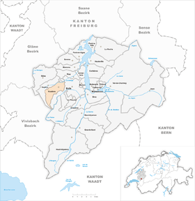
| Location of the municipality | |
  |
|
Vuadens ( Freiburger Patois ) is a municipality in the Gruyère district of the canton of Friborg in Switzerland . The former German names Wüadingen and Wüdingen are no longer used today.
geography

Vuadens is 803 m above sea level. M. , 3 km west of the district capital Bulle (linear distance). The clustered village extends slightly higher on the southern edge of the valley of the Sionge , on the northern edge of the Alps and on the western edge of the Bulle hollow, at the northern foot of the Moléson massif .
The area of the 10.5 km² municipal area includes a section of the Bulle Mulde and the adjacent pre-Alps. The northern part of the municipality is occupied by the wide valley basin of the Sionge between the range of hills of the Gibloux in the north and the foothills of the Alps in the south. To the south, the municipality extends over the valley of the Russon on the northeastern roof of the forest mountain Les Alpettes , on which at 1340 m above sea level. M. the highest point of Vuadens is reached. In a narrow corner, the area extends further south into the forest area of Les Joux Derrières and to the upper reaches of the Trême . In 1997, 9% of the municipal area was in settlements, 22% in forests and woodlands, 68% in agriculture and a little less than 1% was unproductive land.
Vuadens includes the hamlets of Les Moret ( 793 m above sea level ) on the north side of the Sionge, Les Crous ( 860 m above sea level ) and La Place ( 864 m above sea level ) on the heights between Sionge and Russon as well as numerous individual farms. Neighboring municipalities of Vuadens are Bulle , Gruyères , Vaulruz and an exclave of Echarlens .
population
With 2405 inhabitants (as of December 31, 2018), Vuadens is one of the medium-sized communities in the canton of Friborg. 93.5% of the residents are French-speaking, 1.9% German-speaking and 1.8% Portuguese-speaking (as of 2000). The population of Vuadens was 1193 in 1900. During the 20th century, the population fluctuated between 1150 and 1350 people. Only since 1980 (1138 inhabitants) has a rapid population increase been recorded.
economy
Until the middle of the 20th century, Vuadens was a predominantly agricultural village. In the 19th century, forestry and the manufacture of straw mats also played an important role. Since 1914 there was a factory for the production of milk powder in Vuadens (today the operation is closed).
Even today, livestock and dairy farming and, to a lesser extent, arable farming play an important role in the income structure of the population. Further jobs are available in local small businesses and in the service sector. Since the 1980s, businesses have also settled in the village. Today there are horticultural, construction and transport businesses as well as mechanical workshops, carpenters and painting shops in the area. In the last few decades the village has also developed into a residential community. Many people in employment are therefore commuters who work in the regions of Bulle, Freiburg and Vevey-Montreux.
traffic
The community has good transport connections. It is on the main road from Bulle to Vevey . The next connection to the A12 motorway , which has been open continuously from Bern to Vevey since 1981 and crosses the municipality, is around 4 km from the town center.
On July 1, 1868, the railway line from Romont to Bulle was inaugurated with a stop in the hamlet of Les Moret. The narrow-gauge railway line from Bulle to Châtel-Saint-Denis , which has a train station and another stop in the municipality, was put into operation on July 23, 1903.
history
The municipality of Vuadens was populated very early. The earliest traces of human activity date from the urnfield culture (around 1300 to 1200 years before Christ). The urn graves were discovered under the foundations of a Roman manor.
The place was first mentioned in a document in 516 under the name Wadingum . Later the names appeared in curte Vuadingis (929), Uadengis (1017), Wadens (1145), Vadens (1247), Waddens (1276), Wadin (1471) and Vuadens (1578). The place name goes back to the Burgundian personal name Wado and means with the suffix -ens as much as for the people of the Wado .
The area around Vuadens belonged to the Burgundian King Sigismund in the 6th century, who gave the place to the Abbey of Saint-Maurice in 516 . In the 13th century the lords of Vuippens also received certain rights in Vuadens. In 1317, the Saint-Maurice Abbey agreed with Count Louis of Savoy to exchange Vuadens for Auboranges . The now Savoyard Vuadens came under the administration of Corbières . Together with this rule, the village came into the possession of the county of Gruyères in 1450 .
Due to financial difficulties, Count Michael von Gruyères had to sell the dominion of Corbières with Vuadens to Freiburg in 1553. From then on the village belonged to the Friborg bailiwick of Corbières. After the collapse of the Ancien Régime (1798), Vuadens belonged to what was then the Bulle district during the Helvetic Republic and the subsequent period until 1848 before it was incorporated into the Gruyères district.
Attractions
After Vuadens became a parish independent of Bulle in 1602, the Saint-Sylvestre church was built, which was enlarged in 1788 and burned down in 1866. The present church was then rebuilt and consecrated in 1869.
Personalities
- Christian Levrat (* 1970), politician (SP), lives in Vuadens
Web links
- Official website of the municipality of Vuadens (French)
- Aerial views of the village
- François Genoud: Vuadens. In: Historical Lexicon of Switzerland .
Individual evidence
- ↑ Permanent and non-permanent resident population by year, canton, district, municipality, population type and gender (permanent resident population). In: bfs. admin.ch . Federal Statistical Office (FSO), August 31, 2019, accessed on December 22, 2019 .
Bas-Intyamon | Botterens | Broc | Bull | Châtel-sur-Montsalvens | Corbières | Crésuz | Echarlens | Grandvillard | Gruyères | Hauteville | Haut-Intyamon | Jaun | La Roche | Le Pâquier | Marsens | Morlon | Pont-en-Ogoz | Pont-la-Ville | Riaz | Sâles | Sorens | Val-de-Charmey | Vaulruz | Vuadens
Former municipalities: Albeuve | Avry-devant-Pont | Cerniat | Charmey | Enney | Estavannens | Gumefens | La Tour-de-Trême | Le Bry | Lessoc | Maules | Montbovon | Neirivue | Romance | Rueyres-Treyfayes | Villarbeney | Villars-d'Avry | Villars-sous-Mont | Villarvolard | Vuippens
Canton of Friborg | Districts of the canton of Friborg | Municipalities of the canton of Friborg