
Châtel-Saint-Denis
| Châtel-Saint-Denis | |
|---|---|
 |
|
| State : |
|
| Canton : |
|
| District : | Vivisbach |
| BFS no. : | 2325 |
| Postal code : | 1618 |
| UN / LOCODE : | CH CSD |
| Coordinates : | 558757 / 152991 |
| Height : | 809 m above sea level M. |
| Height range : | 637–2013 m above sea level M. |
| Area : | 47.93 km² |
| Residents: | 6971 (December 31, 2018) |
| Population density : | 145 inhabitants per km² |
| Website: | www.chatel-st-denis.ch |
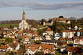
 View of Châtel-Saint-Denis |
|
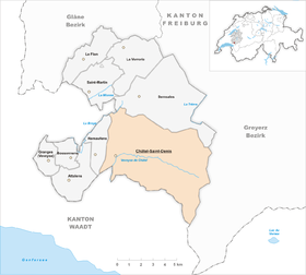
| Location of the municipality | |
  |
|
Châtel-Saint-Denis ( Friborg Patois ) is a political municipality and capital of the Veveyse district (German: Vivisbach district) in the canton of Friborg in Switzerland . The former German name Kastels Sankt Dionys is no longer used today.
geography
Châtel-Saint-Denis is 809 m above sea level. M. , 9 km north-northeast of Vevey (air line). The village is located directly on the watershed between the catchment areas of the Rhone and Rhine , on a hilltop between the Veveyse de Châtel (in the catchment area of the Rhône) and the Tatrel (side brook of the Broye in the catchment area of the Rhine). Châtel-Saint-Denis extends on a plateau at the foot of the Freiburg Pre-Alps .
The area of the 47.9 km² municipal area includes a section of the higher Freiburg Central Plateau and the neighboring Freiburg Pre-Alps . The western part of the municipality is occupied by the gently undulating highlands of the Haute-Veveyse, which on average are 830 m above sea level. M. lies. Here lies the Lac de Lussy , also Lac Lussy ( 820 m above sea level ) in a swampy valley . The northern and western parts of this high plateau are drained by the streams Corjon , Dâ (forms the northern municipal boundary) and Tatrel to Broye. To the southwest, the area extends to the ridge of Mont Vuarat (up to 890 m above sea level ).
The much larger pre-alpine part of the municipality lies in the catchment area of the two source brooks of the Veveyse, namely the Veveyse de Fégire and the Veveyse de Châtel . These two streams have created deep valleys in the flysch zone west of the Moléson range over time. The southern border of the municipality runs exactly along the Veveyse de Fégire. This is followed in the north by the height of Corbetta ( 1400 m above sea level ) with the mountain lake and nature reserve Lac des Joncs as well as the Pralet forest crest (up to 1630 m above sea level ). North of these flysch heights is the holiday region of Les Paccots in the valley of the Veveyse de Châtel, which in turn is flanked in the north by the rounded pyramid of Niremont ( 1514 m above sea level ). The natural eastern border of the municipality of Châtel-Saint-Denis lies on the ridge of the Moléson chain with the limestone peaks Teysachaux ( 1909 m above sea level ), Dent de Lys (at 2014 m above sea level the highest point in the municipality) , Folliu Borna ( 1849 m above sea level ) and Vanil des Artses ( 1991 m above sea level ). A hiking trail leads over the Col de Lys ( 1779 m above sea level ) to Albeuve in the Saane valley . In 1997, 6% of the municipal area was in settlements, 42% in forests and woodlands, 48% in agriculture and around 4% was unproductive land.
Châtel-Saint-Denis includes the extensive holiday complex Les Paccots ( 1061 m above sea level ) on the southern slope of the Veveyse de Châtel and on the slopes of the Corbetta, the hamlet of Fruence ( 833 m above sea level ) southeast of the village on the Plateau between the two source streams of the Veveyse, Prayoud ( 869 m above sea level ), Villard ( 862 m above sea level ) and Prautey ( 862 m above sea level ) at the west foot of the Niremont, La Frasse ( 996 m above sea level) . ) on the lower southwest slope of the Niremont and Le Chaussin ( 914 m above sea level ) on a terrace on the western slope of the Corbetta as well as numerous individual farms scattered over the entire area. Neighboring municipalities of Châtel-Saint-Denis are Semsales , Haut-Intyamon and Remaufens in the canton of Friborg and Blonay , Saint-Légier-La Chiésaz , Corsier and Maracon in the canton of Vaud .
population
| Population development | |||
|---|---|---|---|
| year | Residents | year | Residents |
| 1850 | 2339 | 1970 | 2842 |
| 1900 | 2509 | 1980 | 3141 |
| 1910 | 2708 | 1990 | 3797 |
| 1930 | 2553 | 2000 | 4389 |
| 1950 | 2908 | 2010 | 5727 |
| 1960 | 2666 | ||
With 6971 inhabitants (as of December 31, 2018), Châtel-Saint-Denis is one of the medium-sized municipalities in the canton of Friborg. 89.1% of the residents are French-speaking, 4.4% Portuguese-speaking and 2.7% speak German (as of 2000). The population of Châtel-Saint-Denis hovered between 2500 and 2900 for a long time during the 20th century. Only since 1980, with the continuous opening of the Bern-Vevey autobahn, has the community recorded significant population growth. The population has increased by 50% since then.
economy
Châtel-Saint-Denis was an agricultural village until the beginning of the 20th century . A number of industrial companies began to settle in around 1900, including a milk powder factory, which was relocated to Vuadens in 1914 , as well as a cigar factory and companies that had specialized in the manufacture of cane furniture and wickerwork.
Today, as a regional center, Châtel-Saint-Denis offers around 2,300 jobs. With 6% of the workforce who are still employed in the primary sector, agriculture only has a minor role in the employment structure of the population. Around 32% of the workforce is employed in the industrial sector, while the service sector accounts for 62% of the workforce (as of 2001).
Agriculture in Châtel-Saint-Denis is still mainly represented by dairy farming and cattle breeding ; Agriculture is of little importance . The vast forests are used for forestry .
Since the 1980s, larger commercial and industrial zones have emerged in the Veveyse de Châtel valley and on the high plateau between Châtel-Saint-Denis and Fruence with the improved transport links through the motorway. Today, companies from the construction and transport industry, metal construction, electrical engineering, pharmaceutical industry, food processing, mechanical engineering, wood processing, waste recycling and textile industries are represented in the municipality. Châtel-Saint-Denis is the location of the Société des laiteries châteloises réunies (milk cooperative), which was founded in 1922 and produces Gruyère cheese and Vacherin .
In recent decades, Châtel-Saint-Denis has also developed into a residential community that is cheap compared to the Lake Geneva communities, but still easily accessible. Many workers are therefore commuters who do their work in the Vevey-Montreux region or in Lausanne .
tourism
The mountain area of Châtel-Saint-Denis with the center of Les Paccots is a popular excursion, hiking and skiing area. There are numerous holiday homes in Les Paccots. The terrain is suitable for long summer hikes. The main season, however, is winter, when there is enough snow on the slopes of Corbetta and Niremont when many ski lifts are in operation.
traffic
The community is very well developed in terms of transport. It is located on the old main road from Vevey to Bulle . The next connection to the A12 motorway , which has been open from Bern to Vevey since 1981 , is around 2 km from the town center.
On April 29, 1901, the municipality was connected to the Swiss railway network with the opening of the narrow-gauge railway line from Palézieux-Gare to Châtel-Saint-Denis. On July 23, 1903, the railway line from Châtel-Saint-Denis to Bulle was also put into operation. The connection with the Lake Geneva area took place in 1904 with the inauguration of the line from Vevey to Châtel-Saint-Denis. However, this route was replaced by a bus route in 1970. Until 2019, the Châtel-Saint-Denis station was a dead end on the Bulle-Palézieux line . Since the opening of the new through station , the line can be operated without a hairpin. In addition to the aforementioned bus route to Vevey, those of the Transports publics Fribourgeois , which operate to Les Paccots, also provide for the fine distribution of public transport .
history


The Châtel-Saint-Denis area was populated very early. In the vicinity of Lac de Lussy, for example, traces of settlements that were inhabited in the Palaeolithic and Mesolithic periods were found. Individual objects have also come down to us from the Celtic and Roman times .
The origin of today's Châtel-Saint-Denis lies in a castle that was built in the 11th century on the promontory of Vieux Châtel above the confluence of the Veveyse de Châtel and Veveyse de Fégire. This castle, around which a small settlement developed over time, belonged to the Lords of Fruence. In 1244 it came under the sovereignty of Peter II of Savoy .
In 1296, the then Count of Savoy, Amadeus V, bought the Fruence estate and founded the market town of Châtel-Saint-Denis, which in future also served as the mansion. The old castle and settlement were abandoned and disintegrated within a short time. The newly founded town was given extensive freedom in 1336, but always had only regional significance. The lordship of Châtel-Saint-Denis was under the direct control of the House of Savoy until 1384, after which it belonged to the de Challant family until 1445, before there were several changes of ownership.
Since Friborg was one of the creditors of the Lords of Challant and the owners of the estate at the time, it occupied Châtel-Saint-Denis in 1461 and later bought part of the estate. After Bern had conquered Vaud in 1536, Châtel-Saint-Denis finally came under the sovereignty of the Friborg. In 1574, the new rulers established the Châtel-Saint-Denis bailiwick , which included the area of what is now the communes of Châtel-Saint-Denis, Remaufens and Semsales.
During the 18th century, Châtel-Saint-Denis achieved a certain level of economic prosperity thanks to its location on the trade route from Gruyère to Vevey. After the collapse of the Ancien Régime (1798), the village was the capital of the Châtel-Saint-Denis district during the Helvetic and the following period, before it became part of the Veveyse district with the new cantonal constitution in 1848. During the 19th century there were several waves of emigration to Brazil and Baradero in Argentina , as Châtel-Saint-Denis lived mainly from agriculture and had practically no industry.
Attractions
The parish of Châtel-Saint-Denis is mentioned as early as 1228. The former parish church of Saint-Denis dates from the late 13th century and was replaced by a new building in the 17th century. The current three-aisled parish church of Saint-Denis was built from 1872 to 1875 in the neo-Gothic style and has interior fittings from the time it was built. Nearby is the castle, which originally dates back to the 13th century, but was largely rebuilt during the 18th century.
There are several chapels in the hamlets of the commune, including the Saint-Roch chapel from 1655, Notre-Dame-du-Scex (1867), the Saint-Blaise chapel (1902) in Prayoud and Notre-Dame-des-Neiges (1935) in Les Paccots. Fruence still has a remarkable double farmhouse from the 15th century with a pointed arch portal.
Châtel-Saint-Denis

railway station

church


sons and daughters of the town
- Luca Aerni (* 1993), skier
- Vincent Ducrot (born 1962), manager
- Alexandre Imperatori (* 1987), racing driver
- Frank Pasche (* 1993), track cyclist
- Léonore Porchet (* 1989), politician
Web links
- Official website of the municipality of Châtel-Saint-Denis
- Jean-Claude Vial: Châtel-Saint-Denis (municipality). In: Historical Lexicon of Switzerland .
- Aerial views of Châtel-Saint-Denis and its surroundings
Individual evidence
- ↑ Permanent and non-permanent resident population by year, canton, district, municipality, population type and gender (permanent resident population). In: bfs. admin.ch . Federal Statistical Office (FSO), August 31, 2019, accessed on December 22, 2019 .
- ↑ Spelling Lac Lussy on geo.admin.ch
- ↑ Christophe Mauron: La reencarnación de Helvetia - Historia de los suizos en Baradero (1856-1956) . Sociedad Suiza de Baradero y Association Baradero-Friborg, Baradero 2006, ISBN 950-02-9842-2 .
Attalens | Bossonnens | Châtel-Saint-Denis | Le Flon | Granges | Remaufens | Saint-Martin | Semsales | La Verrerie
Former parishes: Besencens | Bouloz | Fiaugères | Grattavache | La Rougève | Le Crêt | Pont | Porsel | Progens
Canton of Friborg | Districts of the canton of Friborg | Municipalities of the canton of Friborg