
Semsales
| Semsales | |
|---|---|
 |
|
| State : |
|
| Canton : |
|
| District : | Vivisbach |
| BFS no. : | 2336 |
| Postal code : | 1623 |
| Coordinates : | 560880 / 158227 |
| Height : | 866 m above sea level M. |
| Height range : | 805–1937 m above sea level M. |
| Area : | 29.36 km² |
| Residents: | 1413 (December 31, 2018) |
| Population density : | 48 inhabitants per km² |
| Website: | www.semsales.ch |
| Location of the municipality | |
  |
|
Semsales ( Freiburger Patois ) is a municipality in the Veveyse district (German: Vivisbach district) in the canton of Friborg in Switzerland .
geography
Semsales is at 866 m above sea level. M., 10 km west-southwest of Bulle (linear distance). The village extends over a small cone of debris that the Mortivue torrent has accumulated over time at the western foot of the heights of Les Alpettes and Niremont , on the high plateau of the Haute-Veveyse north of Châtel-Saint-Denis, at the foot of the Friborg Prealps .
The area of the 29.4 km² municipal area includes a section of the higher Freiburg Central Plateau and the adjacent Freiburg Alps. The westernmost part of the area is occupied by the valley level on the upper reaches of the Broye . The Broye flows from the pre-Alpine heights to the east, including the Mortivue , the Ruisseau Vesenand and the Dâ (forms the southern municipal boundary). The headwaters of the Broye and Sionge (tributary of the Saane ) are located on the northern slope of Les Alpettes .
The main part of the municipality is made up of the rounded mountain tops of Les Alpettes ( 1413 m above sea level ) and Niremont ( 1514 m above sea level ). These heights, consisting of flysch , have extensive mountain pastures in the hilltop and ridge area, while the slopes are predominantly made up of fir forests. To the east of these heights is the remote upper part of the Trême Valley (the course of the river forms the eastern border for long stretches), which is also densely forested. The communal soil extends in a narrow corner to the southeast into the headwaters of the Trême on Alp Tremetta on the western slope of the Moléson limestone massif . Here, with Teysachaux ( 1909 m above sea level ) and the western summit of Moléson ( 1939 m above sea level ), the highest peaks of Semsales are reached. In 1997, 3% of the municipal area was in settlements, 48% in forests and woodlands, 47% in agriculture and a little more than 2% was unproductive land.
Semsales includes the hamlet of La Rougève ( 812 m above sea level ) at the confluence of the Dâ and the Broye, as well as numerous individual farms and alpine farms scattered across the area. Neighboring municipalities of Semsales are Saint-Martin , La Verrerie , Sâles , Vaulruz , Gruyères , Haut-Intyamon and Châtel-Saint-Denis in the canton of Friborg and Maracon in the canton of Vaud .
population
With 1,413 inhabitants (as of December 31, 2018), Semsales is one of the medium-sized communities in the canton of Friborg. 93.8% of the residents speak French, 2.9% speak German and 0.9% speak Portuguese (as of 2000). The population of Semsales was 981 in 1900. After the population had risen to 1,030 by 1920, a clear decrease of 20% to 824 inhabitants was registered by 1960. Since then, the population has increased again, which has increased particularly since the 1980s.
economy
Semsales was a predominantly agricultural village until the second half of the 20th century . Even today, livestock and dairy farming play an important role in the income structure of the population. The community has extensive alpine pastures for the summer grazing of the livestock.
Numerous other jobs are available in local small businesses and in the service sector, including in wood processing companies, cheese production, in painting shops and in precision engineering workshops. In the past few decades, Semsales has also developed into a residential community. Many workers are therefore commuters who work mainly in Châtel-Saint-Denis as well as in the regions of Vevey-Montreux and Bulle.
traffic
The community has good transport links. It is located on the old main road from Vevey to Bulle . The next connection to the A12 motorway , which has been open continuously from Bern to Vevey since 1981 and crosses the municipality, is around 6 km from the town center.
On July 23, 1903, the railway line from Châtel-Saint-Denis to Bulle was put into operation with a train station in Semsales and a stop at La Verrerie. The bus line, which runs from Semsales to Oron-la-Ville and partly to Mézières , ensures the fine distribution of public transport .
history
The place was first mentioned in a document in 1157 under the name Sessales . Later the names Setsales (1160), Septem Salis (1177), Satsales (1219), Sasales (1260), Septsales (1560) and Sempsales (1857) appeared. The place name is made up of the Latin word septem (seven) and the Germanic sala (residence).
In the 12th century, the Canons of the Great Saint Bernhard founded a priory in Semsales. The settlement of Semsales was devastated by a landslide in the 13th century and was then rebuilt a little further to the southwest at its current location.
After Bern had conquered Vaud, Semsales came under the rule of Freiburg in 1537 and was initially assigned to the Vogtei Rue . In 1581 it moved to the Bailiwick of Châtel-Saint-Denis. After the collapse of the Ancien Régime (1798), the village belonged to what was then the Châtel-Saint-Denis district during the Helvetic and the following period before being incorporated into the Veveyse district in 1848. In the 19th century, Semsales experienced a certain economic boom thanks to the glassworks in neighboring La Verrerie. In 1830, however, numerous houses were destroyed in a fire. With effect from January 1, 1968, the previously independent municipality of La Rougève was incorporated into Semsales.

Attractions
The current parish church of Semsales was built in 1926 and contains important works by Gino Severini and Alexandre Cingria . Of the former village church, which was built in 1630, only the bell tower remains. In the old town center there are still some characteristic Freiburg farmhouses from the 18th and 19th centuries.
photos

Grand-Rue and Church

Ancienne Eglise
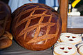
Cuchaule (saffron bread)

Désalpes (alpine descent)


Web links
- Official website of the municipality of Semsales (French)
- Jean-Claude Vial: Semsales. In: Historical Lexicon of Switzerland .
- Aerial views of the village
Individual evidence
- ↑ Permanent and non-permanent resident population by year, canton, district, municipality, population type and gender (permanent resident population). In: bfs. admin.ch . Federal Statistical Office (FSO), August 31, 2019, accessed on December 22, 2019 .
Attalens | Bossonnens | Châtel-Saint-Denis | Le Flon | Granges | Remaufens | Saint-Martin | Semsales | La Verrerie
Former parishes: Besencens | Bouloz | Fiaugères | Grattavache | La Rougève | Le Crêt | Pont | Porsel | Progens
Canton of Friborg | Districts of the canton of Friborg | Municipalities of the canton of Friborg