
Rue FR
| FR is the abbreviation for the canton of Friborg in Switzerland and is used to avoid confusion with other entries of the name Rue . |
| Rue | |
|---|---|
 |
|
| State : |
|
| Canton : |
|
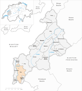
| District : | Glane |
| BFS no. : | 2097 |
| Postal code : | 1673 |
| Coordinates : | 552 785 / 163 319 |
| Height : | 675 m above sea level M. |
| Height range : | 550–848 m above sea level M. |
| Area : | 11.20 km² |
| Residents: | 1526 (December 31, 2018) |
| Population density : | 136 inhabitants per km² |
| Website: | www.rue.ch |
.jpg) View of Rue |
|
| Location of the municipality | |
  |
|
Rue ( Freiburger Patois ) is a municipality in the Glane district in the canton of Friborg in Switzerland . The former German name Rüw is no longer used today. On January 1, 2001, the previously independent communities Promasens and Gillarens were incorporated into Rue.
geography
Rue is 675 m above sea level. M. , 12 km southwest of the district capital Romont and 6 km south-southeast of Moudon (air line). The historic town extends on a promontory on the eastern slope of the Broye valley , in a panoramic location around 100 m above the course of the river, in the southwest of the Freiburg Central Plateau .
The area of the 11.2 km² municipal area covers a section of the Molasse hill country on the upper reaches of the Broye. The western border is always formed by the course of the Broye river, which meanders through the valley plain, which is up to 1 km wide, especially in the southern part. From the valley floor, the municipality extends eastward over the gently sloping slope to the adjacent Molasse heights, on which above Vauderens at 840 m above sea level. M. the highest point of Rue is reached. This slope is drained by a series of small streams to the Broye. In the northern part of the municipality, the protrusion of Rue (up to 715 m above sea level ) runs from the plateau at Ursy to the south-southwest and ends with a small rocky plateau on which the castle stands, towards the Broyetal. The town of Rue is located on the south and south-east flanks of this ledge. In the far south, the communal soil extends into the Bois du Mont forest near Oron-la-Ville. In 1997, 8% of the municipal area was in settlements, 17% in forests and woodlands, 74% in agriculture and a little less than 1% was unproductive land.
The villages of Promasens ( 607 m above sea level ) and Gillarens ( 671 m above sea level ), the hamlets of Blessens ( 706 m above sea level ) and Arlens ( 691 m above sea level ) on the eastern upper valley slope belong to Rue the Broye as well as some farm settlements and individual farms. The neighboring municipalities of Rue are Auboranges , Ecublens , Montet (Glâne) , Ursy , Le Flon and Chapelle (Glâne) in the canton of Friborg and Oron in the canton of Vaud .

population
With 1526 inhabitants (as of December 31, 2018), Rue is one of the medium-sized communities in the canton of Friborg. 96.9% of the residents are French-speaking, 1.3% German-speaking and 0.7% speak Portuguese (as of 2000). The population of Rue was 1082 in 1900 (including the villages that are now incorporated). In the course of the first half of the 20th century, the population remained almost constant and in 1950 reached its highest level of 1,155 people. After that, a strong emigration began, so that in 1980 Rue only had 799 inhabitants. Only since then has there been significant population growth again.
economy
Until the second half of the 20th century, Rue was predominantly an agricultural community. Today who have dairy industry , the livestock and agriculture an important role in the employment structure of the population. Further jobs are available in local small businesses and in the service sector. The more important companies include a sawmill and a transport company. In the last few decades the village has also developed into a residential community thanks to its attractive location. Many workers are therefore commuters who work mainly in the Moudon and Oron-la-Ville regions.
traffic
While Promasens is on the Broyetalstrasse from Moudon to Oron-la-Ville , Rue and Gillarens are easily accessible from this street. Rue is connected to the public transport network by the Transports publics Fribourgeois bus , which runs from Romont via Ursy to Palézieux-Gare . The upper part of the municipality is also crossed by the railway line from Lausanne to Freiburg , but there is no stop there. The nearest train station is in Vauderens, around two kilometers from Rue.
history
The first documentary mention of the place was probably in 1101 (not properly clarified) under the name Rouda . Later the names Rota (1147), Rua la villa (1221), Rou and Roa (1237), then Roda , Rotavilla and Ruaz appeared . The place name goes back to the Latin word rota (wheel).
Since the Middle Ages , Rue has been the center of the eponymous rule, whose castle was probably built in the early 12th century and was first mentioned in 1155 as Castrum Rote . The lords of Rue were vassals of the Counts of Geneva. During the armed conflict between the barons residing in Vaud and the Savoy in the first half of the 13th century, Rue Castle was besieged twice by the latter. Around 1260 the rulership of Rue came under the sovereignty of Savoy . It was converted into a Kastlanei, which was subordinate in civil and legal matters to the Vogt of Vaud, who resided in Moudon.
Under the Savoy, between 1264 and 1271, the town of Rue was founded below the castle. The town never achieved greater importance and was prevented from developing in the 14th century by the plague epidemics. During the Burgundian Wars , Rue was conquered by Friborg troops in 1476, but returned to Savoy in the subsequent peace treaty.
When the Bernese conquered Vaud in 1536, the rulership of Rue came under the suzerainty of Friborg. These new rulers converted the rule into the Vogtei Rue, which included the upper Broyetal and the southeastern adjoining areas up to the Mionna Valley . After the collapse of the Ancien Régime (1798), Rue was part of the Rue district during the Helvetic and the subsequent period and was incorporated into the newly created Glâne district in 1848.
The municipal area of Rue expanded for the first time when, on January 1, 1993, the previously independent Blessens was incorporated into Rue. As part of the community mergers supported by the canton of Friborg since 2000, the villages of Promasens and Gillarens further south were also merged with Rue with effect from January 1, 2001 .
Attractions

The Rue Castle was built in the early 12th century in a strategically excellent location on a rocky plateau made of molasses sandstone. One of the oldest preserved parts is the massive square keep, the shape of which clearly dates back to the pre-Savoy era. It dominated the northeastern part of the complex and is the only access to the plateau. The property is protected to the west by a tower. After the castle was damaged during the siege by the Savoy, it was repaired again in the second half of the 13th century. Major changes were made after Rue became the bailiff's seat. The current residential buildings in the extreme southwest at the top of the plateau were built in the Renaissance style between 1618 and 1630 . Today the castle is privately owned.
The town of Rue was founded around 1270 within the outer ring walls of the castle. It still has a picturesque townscape with a remarkable structure. The Catholic Church of Saint-Nicolas, which stands below the castle and was founded by Knight Richard von Prez around 1336 , was rebuilt in the 18th century and expanded in the 19th century. Next to it is the Dupraz house from the 16th century. Other characteristic town houses from the 16th to 19th centuries have been preserved.
Image gallery

City view from Rue

Saint Nicolas Church
school

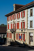
Rue du Casino (center)

Castle, keep

lock


Web links
- Official website of the municipality of Rue (French)
- Marianne Rolle: Blessens. In: Historical Lexicon of Switzerland .
- Evelyne Maradan: Gillarens. In: Historical Lexicon of Switzerland .
- Ernst Tremp: Arlens. In: Historical Lexicon of Switzerland .
- Florian Defferrard: Rue (parish). In: Historical Lexicon of Switzerland .
- Aerial views of Rue
Individual evidence
- ↑ Permanent and non-permanent resident population by year, canton, district, municipality, population type and gender (permanent resident population). In: bfs. admin.ch . Federal Statistical Office (FSO), August 31, 2019, accessed on December 22, 2019 .
- ↑ François Ducrest: Note complémentaire sur Richard de Prez . In: Journal of Swiss Church History , Vol. 2, 1908. Page 295.
Auboranges | Billens-Hennens | Chapelle (Glâne) | Châtonnaye | Ecublens | Grangettes | Le Châtelard | Massonnens | Mezieres | Montet (Glâne) | Romont | Rue | Siviriez | Torny | Ursy | Villaz | Villorsonnens | Vuisternens-devant-Romont
Former parishes: Arrufens | Berlens | Bionnens | Billens | Blessens | Chavannes-les-Forts | Chavannes-sous-Orsonnens | Eschiens | Esmonts | Estévenens | Fuyens | Gillarens | Grange-la-Battiaz | Hennens | La Folliaz | La Joux | La Magne | La Neirigue | Le Saulgy | Les Ecasseys | Les Glânes | Lussy | Lieffrens | Macconnens | Middes | Morlens | Mossel | Orsonnens | Prez-vers-Siviriez | Promasens | Sommentier | Torny-le-Grand | Vauderens | Villangeaux | Villaraboud | Villaranon | Villargiroud | Villariaz | Villarimboud | Villarsiviriaux | Villaz-Saint-Pierre | Vuarmarens
Canton of Friborg | Districts of the canton of Friborg | Municipalities of the canton of Friborg