
Ursy
| Ursy | |
|---|---|
 |
|
| State : |
|
| Canton : |
|
| District : | Glane |
| BFS no. : | 2102 |
| Postal code : | 1670 Bionnens 1670 Esmonts 1670 Ursy 1674 Morlens 1674 Vuarmarens 1675 Mossel 1675 Vauderens |
| Coordinates : | 553 713 / 165010 |
| Height : | 704 m above sea level M. |
| Height range : | 649–876 m above sea level M. |
| Area : | 14.93 km² |
| Residents: | 3198 (December 31, 2018) |
| Population density : | 214 inhabitants per km² |
| Website: | www.ursy.ch |
 Ursy |
|
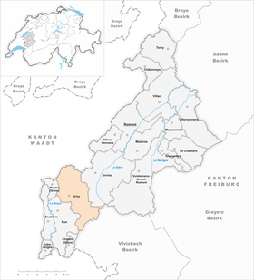
| Location of the municipality | |
  |
|
Ursy is a municipality in the Glane district in the canton of Friborg in Switzerland . With effect from January 1, 2001, the previously independent municipalities of Bionnens , Mossel and Vauderens were merged with the municipality of Ursy and on January 1, 2012 Vuarmarens (including the previously incorporated Esmonts and Morlens ) was incorporated into Ursy.
geography
Ursy lies at 704 m above sea level. M. , 9 km southwest of the district capital Romont and 5 km southeast of Moudon (air line). The village extends on a plateau east of the upper reaches of the Broye , at the southwestern foot of the Signal d'Esmonts , in the southwestern Freiburg Central Plateau .
The area of the 14.9 km² municipal area includes a section of the Molasse hill country of the Freiburg Central Plateau. The area extends from the Ursy plateau, which is bordered in the north by the Bois du Mont (up to 823 m above sea level ) on the Signal d'Esmonts, east over the slope of Vauderens to the adjacent Molasse heights Le Meylan ( 866 m above sea level ) above sea level ) and La Crêta ( 872 m above sea level ). To the southeast of this ridge, the communal soil extends into the headwaters of the Glâne , the Invau basin and the Maflon brook , whose water flows together with the Flon to the Broye. In the forest area La Râpe east of the Mulde von Invau is 875 m above sea level. M. reached the highest point of Ursy. The southernmost part of the area is occupied by the height of Mossel ( 820 m above sea level ). In 1997, 8% of the municipal area was accounted for by settlements, 24% by forests and woodlands and 68% by agriculture.
Ursy includes the villages of Esmonts ( 828 m above sea level ), Vauderens ( 757 m above sea level ) and Vuarmarens ( 783 m above sea level ), the hamlets of Mossel ( 818 m above sea level ), Invau ( 805 m above sea level ) m above sea level ) in the hollow east of the height La Crêta, Fin de Vau ( 821 m above sea level ) on the southern slope of La Crêta and Pré du Château ( 848 m above sea level ) north of the Meylan, Morlens ( 725 m above sea level ) m above sea level ) as well as some farm settlements and individual farms. Ursy's neighboring municipalities are Siviriez , Le Flon , Rue and Montet (Glâne) in the canton of Friborg and Lucens and Chavannes-sur-Moudon in the canton of Vaud .
population
With 3198 inhabitants (as of December 31, 2018) Ursy is one of the medium-sized municipalities in the canton of Friborg. 91.5% of the residents speak French, 3.3% speak Portuguese and 2.3% speak Albanian (as of 2000). The population of Ursy was 1140 in 1900 (including the villages that are incorporated today). During the 20th century it commuted between 1000 and 1200 people. Only since around 1980 (1199 inhabitants) has a significant increase in population been recorded (especially of Ursy, Vauderens and Vuarmarens).
economy
Until the middle of the 20th century, Ursy was predominantly an agricultural community. Even today, dairy farming , cattle breeding and arable farming have a certain place in the income structure of the population. Since the 1950s, a number of small and medium-sized companies have settled in Ursy, which significantly changed the economic structure of the municipality. The most important company in Ursy today is Mifroma SA . It was founded in 1964, operates a cheese cellar for the refinement of Gruyère cheese and is now part of the Migros retail company . In addition, companies from the building trade, the food industry, organ building, mechanical workshops and architectural offices are represented in the community. In the last few decades the village has also developed into a residential community thanks to its attractive location. Many workers are therefore commuters who work mainly in the Moudon and Oron-la-Ville regions.
traffic
The community is very well developed in terms of traffic. It is located on the main road from Romont to Moudon . Ursy is connected to the public transport network by the bus lines of the Freiburg public transport company , which run from Romont via Ursy and Oron-la-Ville to Palézieux-Gare and from Romont via Ursy and Vauderens to Moudon. In Vauderens the station is on the railway line from Lausanne to Friborg , which went into operation on September 4, 1862.
history
The place was first mentioned in a document around 1160 under the name Ursei . Later the names Urseio (1190), Ursez (1215) and Ursi (1235) appeared. The place name goes back to the Gallo-Roman personal name Ursius .
Ursy belonged to the rulership of Rue in the Middle Ages and came under the sovereignty of the Counts of Savoy in the middle of the 13th century . When the Bernese conquered Vaud in 1536, the village came under the rule of Friborg and was assigned to the Vogtei Rue. After the collapse of the Ancien Régime (1798), Ursy belonged to the Rue district during the Helvetic and the following period and was incorporated into the Glâne district in 1848.
As part of the community mergers funded by the canton of Friborg since 2000, the previously independent communities of Bionnens , Vauderens and Mossel were incorporated into Ursy with effect from January 1, 2001.
Attractions
The parish church of Ursy was built in 1859. It is the main church in the parish of Ursy-Morlens.
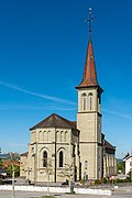
Saint Maurice Church

Rectory

Old school house

New school house

New school house

Gym

Parish hall

Village center

former farmhouse


Web links
- Official website of the municipality of Ursy (French)
- Aerial photos of Ursy
- Marianne Rolle: Ursy. In: Historical Lexicon of Switzerland .
Individual evidence
- ↑ Permanent and non-permanent resident population by year, canton, district, municipality, population type and gender (permanent resident population). In: bfs. admin.ch . Federal Statistical Office (FSO), August 31, 2019, accessed on December 22, 2019 .
Auboranges | Billens-Hennens | Chapelle (Glâne) | Châtonnaye | Ecublens | Grangettes | Le Châtelard | Massonnens | Mezieres | Montet (Glâne) | Romont | Rue | Siviriez | Torny | Ursy | Villaz | Villorsonnens | Vuisternens-devant-Romont
Former parishes: Arrufens | Berlens | Bionnens | Billens | Blessens | Chavannes-les-Forts | Chavannes-sous-Orsonnens | Eschiens | Esmonts | Estévenens | Fuyens | Gillarens | Grange-la-Battiaz | Hennens | La Folliaz | La Joux | La Magne | La Neirigue | Le Saulgy | Les Ecasseys | Les Glânes | Lussy | Lieffrens | Macconnens | Middes | Morlens | Mossel | Orsonnens | Prez-vers-Siviriez | Promasens | Sommentier | Torny-le-Grand | Vauderens | Villangeaux | Villaraboud | Villaranon | Villargiroud | Villariaz | Villarimboud | Villarsiviriaux | Villaz-Saint-Pierre | Vuarmarens
Canton of Friborg | Districts of the canton of Friborg | Municipalities of the canton of Friborg