Billens-Hennens
| Billens-Hennens | |
|---|---|
| State : |
|
| Canton : |
|
| District : | Glane |
| BFS no. : | 2063 |
| Postal code : | 1681 |
| UN / LOCODE : | CH BIL (Billens) |
| Coordinates : | 558 754 / 171149 |
| Height : | 738 m above sea level M. |
| Height range : | 700–816 m above sea level M. |
| Area : | 4.89 km² |
| Residents: | 772 (December 31, 2018) |
| Population density : | 158 inhabitants per km² |
| Website: | www.billens-hennens.ch |
|
Billens |
|
| Location of the municipality | |
Billens-Hennens is a municipality in the Glane district in the canton of Friborg in Switzerland . The municipality was created on January 1, 1998 through the merger of the previously independent municipalities Billens ( Freiburg Patois ) and Hennens (Freiburg Patois ).
geography
Billens-Hennens is 738 m above sea level. M. , 1.5 km west-southwest of the district capital Romont . The community extends slightly higher west of the Glaney valley opposite Romont, on the ridge between the central Broyetal in the west and the upper reaches of the Glâne in the east, in the Freiburg Central Plateau .
The area of the 4.9 km² municipal area comprises a section of the Molasse plateau of the Freiburg Central Plateau. The eastern border runs along the Glaney , a left tributary of the Glâne. From here, the municipality extends westward over the gently undulating landscape to the heights of Dailles ( 807 m above sea level ) and Champ Liamon ( 810 m above sea level ). To the southwest, the area extends over the Haut-du-Bois forest ridge into the catchment area of the Ruisseau des Vaux (right brook of the Broye ). The highest point of Billens-Hennens is 814 m above sea level. M. in the southwest near the farm Montaney . In 1997, 7% of the municipal area was accounted for by settlements, 13% for forests and woodlands and 80% for agriculture.
Billens-Hennens consists of the villages of Billens ( 738 m above sea level ), Hennens ( 763 m above sea level ) in a basin southwest of Billens, the hamlet of La Bioleyre ( 755 m above sea level ) west of the Glaney and several Individual farms. The neighboring municipalities of Billens-Hennens are Romont and Siviriez in the canton of Friborg and Lucens , Lovatens and Prévonloup in the canton of Vaud .
population
With 772 inhabitants (as of December 31, 2018) Billens-Hennens is one of the smaller communities in the canton of Friborg. 96.5% of the residents are French-speaking, 2.4% German-speaking and 0.5% speak Spanish (as of 2000). The population of Billens-Hennens was 336 in 1850 and 437 in 1900. After a peak around 1940 (610 inhabitants), the population decreased by around 17% to 508 people by 1980. Since then, the population has increased significantly again.
economy
Up until the second half of the 20th century, Billens-Hennens was a predominantly agricultural village. In the 19th century there were several mills and sawmills in Billens. Even today, agriculture , cattle breeding and dairy farming have a certain role in the income structure of the population. Further jobs are available in local small businesses and especially in the service sector. Billens is the location of the district hospital of the Glâne district. In the last few decades the village has developed into a residential community. Many employees are therefore commuters who work in Romont or in the Freiburg region.
traffic
Billens is on the road from Romont to Lucens . The PostBus and TPF bus routes that run from Romont to Lucens, Romont to Payerne and Romont to Avry connect Billens to the public transport network. The Romont train station on the Lausanne - Friborg line is just 1 km from the town center . Hennens has no connection to public transport.
history
The first written mention of Billens was in 1155 under the name Bitlens . The names Billens (1180), Billeins (1228) and Byllens (1232) appeared later . The place name is derived from the Burgundian personal name Billa and means with the suffix -ens as much as for the people of Billa . In contrast, Hennens is only attested as Henens since 1403 . Numerous other spellings have been handed down from the following period: Ennens (1432), Henyn (1475), Enens (1578), Inens (1638) and Innens (1755). This place name goes back to the personal name Inno .
Since the Middle Ages , Billens belonged to the noble family of the same name. The Lords of Billens were vassals of the Bishop of Lausanne, and later they were under the sovereignty of the House of Savoy . Romont also belonged to the reign of Billens until 1239. In 1365 the rule came to the Counts of Gruyères through a marriage . There have been numerous changes of ownership since the beginning of the 15th century. Since it was first mentioned, Hennens formed its own small rule that was dependent on Savoy.
When the Bernese conquered Vaud in 1536, Billens and Hennens came under the rule of Freiburg and were assigned to the Bailiwick of Romont. After the collapse of the Ancien Régime (1798), the villages belonged to the Romont district during the Helvetic and the subsequent period and were incorporated into the Glâne district in 1848. On January 1, 1998, the two municipalities merged to form the new political municipality of Billens-Hennens.
Attractions
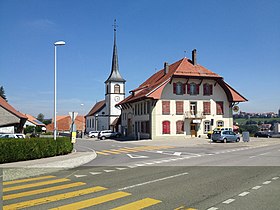
The parish church of Saint-Maurice in Billens was mentioned as early as 1228. It was enlarged in 1659 and redesigned between 1827 and 1831. After the last castle of the Lords of Billens was destroyed in 1718, a new castle was built northeast of the village. This became the property of the canton of Friborg in 1864 and was later expanded to become a district hospital. The Saint Bernard Chapel, built in 1653, is located in Hennens.
Web links
- Official website of the community of Billens-Hennens
- Marianne Rolle: Billens. In: Historical Lexicon of Switzerland .
- Evelyne Maradan: Hennens. In: Historical Lexicon of Switzerland .
- Aerial views of Billens
- Aerial view of Hennens
Individual evidence
- ↑ Permanent and non-permanent resident population by year, canton, district, municipality, population type and gender (permanent resident population). In: bfs. admin.ch . Federal Statistical Office (FSO), August 31, 2019, accessed on December 22, 2019 .
- ↑ RER brochure. (PDF; 1.2 MB) In: Route connections and network plan. RER Friborg | Freiburg, October 31, 2017, p. 9 , accessed on January 10, 2018 (Glanebezirk, page 5, or page 5 in the brochure).


