Villarimboud
| Villarimboud | ||
|---|---|---|
| State : |
|
|
| Canton : |
|
|
| District : | Glane | |
| Municipality : | Villaz | |
| Postal code : | 1691 | |
| former BFS no. : | XXXX | |
| Coordinates : | 563925 / 175 902 | |
| Height : | 756 m above sea level M. | |
| Residents: | 474 (2002) | |
|
Villarimboud |
||
| map | ||
|
|
||
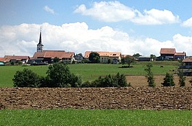
Villarimboud ( Friborg Patois ) is a town and formerly an independent political municipality in the Glane district of the canton of Friborg in Switzerland .
geography
Villarimboud is located at 756 m above sea level. M. , six kilometers northeast of the district capital Romont (linear distance ). The village extends on the wide ridge north of the valley lowlands of the upper Glâne , on the Molasse plateau of the Freiburg Central Plateau . The former municipality area was around 5.4 km². The area extended from the Glâne northward over the valley low to the heights of Villarimboud and Le Châtelet and north of them into the catchment area of the Arbogne . The Tourbière moorland is located in a side hollow of the Glâne valley . At the edge of the forest above Villarimboud is 810 m above sea level. M. reached the highest point of the village.
population
With 474 inhabitants (2002), Villarimboud was one of the small communities in the canton of Friborg before the merger. Especially since 1980 (316 inhabitants) the village recorded a significant increase in population. The hamlet of Macconnens ( 710 m above sea level ) - a formerly independent municipality below the village of Villarimboud - as well as several farm settlements and individual farms belong to Villarimboud.
economy
Until the second half of the 20th century, Villarimboud was predominantly an agricultural village. Today who have dairy industry , the livestock and agriculture an important role in the employment structure of the population. A few other jobs are available in local small businesses and in the service sector, including in a transport company. In the last few decades the village has also developed into a residential community thanks to its attractive location. Many workers are therefore commuters who work mainly in the Romont and Freiburg regions.
traffic
The village is off the main thoroughfares, but is easy to get to from the main road from Freiburg to Romont . The railway line from Lausanne via Romont to Friborg runs close to the village, but has no stop at Villarimboud. The village is connected to the public transport network by a postbus course that runs from the train station in Villaz-Saint-Pierre to Villarimboud.
history
The first written mention of the place took place in 1142 under the name Villarrimolth . The names Villarrembout (1145), Vilar Rembolt and Vilar Reinbold (in the 12th century), Vilarrobot (1228), Villaraymboz (1453), Villarrembloz (1490) and Villarimbo (1668) appeared later . The place name originated from the personal name Rimbald combined with the late Latin word villare (hamlet, farmstead).
Villarimboud has been under the sovereignty of the House of Savoy since the Middle Ages . When the Bernese conquered Vaud in 1536, the village came under the rule of Friborg and was assigned to the Bailiwick of Romont. After the collapse of the Ancien Régime (1798), Villarimboud belonged to the Romont district during the Helvetic and the following period and was incorporated into the Glâne district in 1848.
Villarimboud experienced a first change of territory on January 1, 1973, when the hamlet of Macconnens , which had previously been an independent municipality, was incorporated. As part of the community mergers, which the canton of Friborg has sponsored since 2000, originally a merger of the three villages Lussy, Villarimboud and Villaz-Saint-Pierre was planned. However, since the residents of Villaz-Saint-Pierre resisted a merger, on January 1, 2005 only the previously independent municipalities of Villarimboud and Lussy (FR) were merged to form the new municipality of La Folliaz . On January 1, 2020, La Folliaz merged with Villaz-Saint-Pierre to form the new municipality of Villaz .
Attractions
The Catholic Church of St. Theodul (Saint-Théodule) was built in the years 1841 to 1844 in the style of classicism . Since 2005 it has belonged to the parish of St. Peter and Paul (Saints-Pierre-et-Paul) in Villaz-Saint-Pierre in the diocese of Lausanne, Geneva and Friborg .
Web links
- Marianne Rolle: Villarimboud. In: Historical Lexicon of Switzerland .
- Aerial view of the village


