
Villaz-Saint-Pierre
| Villaz-Saint-Pierre | ||
|---|---|---|
 |
||
| State : |
|
|
| Canton : |
|
|
| District : | Glane | |
| Municipality : | Villaz | |
| Postal code : | 1690 | |
| former BFS no. : | 2111 | |
| Coordinates : | 563152 / 174424 | |
| Height : | 729 m above sea level M. | |
| Area : | 5.53 km² | |
| Population density : | 236 inhabitants per km² | |
| Website: | www.villaz-st-pierre.ch | |
 Villaz-Saint Pierre |
||
| map | ||
|
||


Villaz-Saint-Pierre ( Friborg Patois ) was a municipality in the Glane district of the canton of Friborg in Switzerland until December 31, 2019 . The German name Villaz-Sankt Peter is hardly used today. On January 1, 2020, it merged with La Folliaz to form the new municipality of Villaz .
geography
Villaz-Saint-Pierre is 729 m above sea level. M. , 4 km northeast of the district capital Romont (air line). The village extends on a hill on the north-western edge of the Glânetal , in a panoramic position around 40 m above the valley floor, on the Molasse plateau of the Freiburg Central Plateau .
The area of the 5.5 km² former municipal area comprises a section of the Molasse Heights of the Freiburg Central Plateau. The central part is taken up by the approximately 800 m wide flat valley basin of the Glâne. This is followed by the height of Villaz-Saint-Pierre in the north-west. Further to the north-west, the municipality extends to the Au Bois forest height (at 814 m above sea level, the highest point in Villaz-Saint-Pierre) and into the headwaters of the Arbogne . To the southeast of the Glâne, the area extends over the range of hills with the Bois de Muay ( 750 m above sea level ) into the flat floodplain of the Neirigue . In 1997, 12% of the municipal area was settled, 24% forest and woodland, 63% agriculture and a little less than 1% was unproductive land.
Villaz-Saint-Pierre includes the village of Fuyens ( 715 m above sea level ) at the height between the Glâne and the Neirigue, as well as some farm settlements and individual farms. Neighboring communities of Villaz-Saint-Pierre were La Folliaz , Romont , Mézières , Massonnens , Villorsonnens and Châtonnaye in the canton of Friborg and Villarzel in the canton of Vaud .
population
With 1305 inhabitants (as of December 31, 2018) Villaz-Saint-Pierre was one of the smaller communities in the canton of Friborg. 89.3% of the residents are French-speaking, 2.8% German-speaking and 2.3% speak Albanian (as of 2000). The population of Villaz-Saint-Pierre was 448 in 1900 (including the towns that are incorporated today). In the course of the 20th century, the population increased slowly but continuously. Only since around 1980 (654 inhabitants) has a significant increase in population been recorded.
economy
Villaz-Saint-Pierre was a predominantly agricultural village until the second half of the 20th century . Even today, dairy farming , cattle breeding and arable farming have a certain place in the income structure of the population. Further jobs are available in local small businesses and in the service sector. Information technology companies as well as engineering and fiduciary offices have also established themselves in Villaz-Saint-Pierre since the 1980s. In the last few decades the village has also developed into a residential community thanks to its attractive location. Many workers are therefore commuters who work mainly in the Romont and Freiburg regions.
traffic
Villaz-Saint-Pierre has good transport links. It is located on the main road from Freiburg to Romont . On September 4, 1862, the railway line from Lausanne to Friborg in the Üechtland with a station in Villaz-Saint-Pierre was put into operation. A bus route operated by Transports publics Fribourgeois from Romont to Farvagny and two postbus courses from the Villaz-Saint-Pierre train station to Massonnens and Villarimboud provide for the fine distribution of public transport .
history
The municipality of Villaz-Saint-Pierre was settled very early, which can be attested by the remains of a Roman villa. The first written mention of the place took place in 1177 under the name Villa ; from 1228 Vila has been handed down. The place name is derived from the patois expression vella , villa meaning group of houses .
Since the Middle Ages, Villaz-Saint-Pierre formed its own small lordship, which was dependent on various lords, including those of Billens, Gruyères, Savoy and Romont. When the Bernese conquered Vaud in 1536, the village came under the rule of Friborg and was assigned to the Bailiwick of Romont. After the collapse of the Ancien Régime (1798) Villaz-Saint-Pierre belonged to the Romont district during the Helvetic and the following period and was incorporated into the Glâne district in 1848.
On January 1, 1978, the previously politically independent Fuyens was incorporated into Villaz-Saint-Pierre. As part of the municipal mergers of the canton of Friborg, a merger of the three villages Lussy, Villarimboud and Villaz-Saint-Pierre was originally planned. However, since the residents of Villaz-Saint-Pierre resisted a merger, on January 1, 2005 only the previously independent municipalities of Lussy (FR) and Villarimboud were merged to form the new municipality of La Folliaz .
Attractions
The core of the parish church of Saint-Pierre-et-Paul goes back to a church from the 12th century. The church was given its present form when it was rebuilt in 1843 in the classical style; It was restored in 1943–49.

Church of Saints Peter and Paul
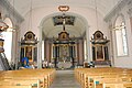
Interior of the church

Ceiling fresco in the church
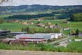
Fuyens and in the background the Gibloux
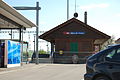
railway station
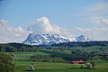
The Moléson as seen from Villaz-Saint-Pierre
_01.jpg)
_11.jpg)
_17.jpg)
_280.JPG)
_300.JPG)
_284.JPG)
Web links
- Official website of the municipality of Villaz-Saint-Pierre (French)
- Dominic Roulin: Villaz-Saint-Pierre. In: Historical Lexicon of Switzerland .
- Aerial views of the village
Auboranges | Billens-Hennens | Chapelle (Glâne) | Châtonnaye | Ecublens | Grangettes | Le Châtelard | Massonnens | Mezieres | Montet (Glâne) | Romont | Rue | Siviriez | Torny | Ursy | Villaz | Villorsonnens | Vuisternens-devant-Romont
Former parishes: Arrufens | Berlens | Bionnens | Billens | Blessens | Chavannes-les-Forts | Chavannes-sous-Orsonnens | Eschiens | Esmonts | Estévenens | Fuyens | Gillarens | Grange-la-Battiaz | Hennens | La Folliaz | La Joux | La Magne | La Neirigue | Le Saulgy | Les Ecasseys | Les Glânes | Lussy | Lieffrens | Macconnens | Middes | Morlens | Mossel | Orsonnens | Prez-vers-Siviriez | Promasens | Sommentier | Torny-le-Grand | Vauderens | Villangeaux | Villaraboud | Villaranon | Villargiroud | Villariaz | Villarimboud | Villarsiviriaux | Villaz-Saint-Pierre | Vuarmarens
Canton of Friborg | Districts of the canton of Friborg | Municipalities of the canton of Friborg